


@nevillekmbc.bsky.social
❄ Light snow is likely Saturday midday into the afternoon/evening. A dusting is possible mainly north of the KC Metro to 36 HWY. 1-3'' of snow could fall north of 36 HWY. Roads will likely be mainly wet, but there might be some slick spots. kmbc.com/weather @kmbc9.bsky.social


November 27, 2025 at 12:07 AM
❄ Light snow is likely Saturday midday into the afternoon/evening. A dusting is possible mainly north of the KC Metro to 36 HWY. 1-3'' of snow could fall north of 36 HWY. Roads will likely be mainly wet, but there might be some slick spots. kmbc.com/weather @kmbc9.bsky.social
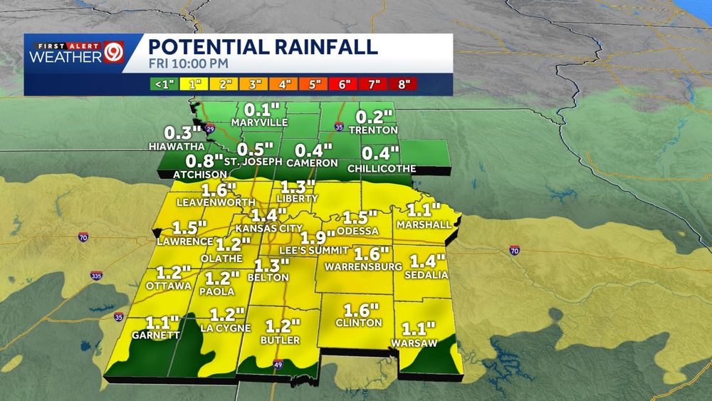
Our next storm system will move in Friday evening late into Saturday. We'll likely start out with rain showers, but snow could mix in for areas closer to the MO/IA border. Snow could make its way into the KC Metro Saturday midday/afternoon. kmbc.com/weather @kmbc9.bsky.social


November 26, 2025 at 3:02 AM
Our next storm system will move in Friday evening late into Saturday. We'll likely start out with rain showers, but snow could mix in for areas closer to the MO/IA border. Snow could make its way into the KC Metro Saturday midday/afternoon. kmbc.com/weather @kmbc9.bsky.social
Rain moves out tonight, then fog thickens up for Tuesday morning. @kmbc9.bsky.social
November 25, 2025 at 12:52 AM
Rain moves out tonight, then fog thickens up for Tuesday morning. @kmbc9.bsky.social
We picked up some much-needed rain last night and today. Forecast totals were generally within a few tenths of the radar rainfall estimates. Next round of rain arrives Monday. @kmbc9.bsky.social

November 22, 2025 at 12:10 AM
We picked up some much-needed rain last night and today. Forecast totals were generally within a few tenths of the radar rainfall estimates. Next round of rain arrives Monday. @kmbc9.bsky.social
We’ve only received about 35% of our normal rainfall since August 1, which is why we’re in a severe drought. Thankfully, we should pick up between 0.5” and 1” of rain Thursday and Friday. @kmbc9.bsky.social


November 20, 2025 at 12:30 AM
We’ve only received about 35% of our normal rainfall since August 1, which is why we’re in a severe drought. Thankfully, we should pick up between 0.5” and 1” of rain Thursday and Friday. @kmbc9.bsky.social
Some much-needed rain will hopefully arrive Thursday into Friday. Areas south of the KC Metro could pick up more than 1” of rain. We’re nearly 5” below normal rainfall since Sept. 1. @kmbc9.bsky.social


November 18, 2025 at 12:40 AM
Some much-needed rain will hopefully arrive Thursday into Friday. Areas south of the KC Metro could pick up more than 1” of rain. We’re nearly 5” below normal rainfall since Sept. 1. @kmbc9.bsky.social
👀 Forecast trends are pointing toward a colder, more winter-like pattern for much of the central and eastern U.S. near the end of the month into early December.
We’re watching it and we’ll keep you updated with the changes! kmbc.com/weather @kmbc9.bsky.social
We’re watching it and we’ll keep you updated with the changes! kmbc.com/weather @kmbc9.bsky.social
November 15, 2025 at 12:33 AM
👀 Forecast trends are pointing toward a colder, more winter-like pattern for much of the central and eastern U.S. near the end of the month into early December.
We’re watching it and we’ll keep you updated with the changes! kmbc.com/weather @kmbc9.bsky.social
We’re watching it and we’ll keep you updated with the changes! kmbc.com/weather @kmbc9.bsky.social
As of 6 p.m., the Northern Lights are not looking as promising to as brilliant as what we saw Tuesday evening. We'll keep an eye on the trends through the evening. Here's what to know! @kmbc9.bsky.social


November 13, 2025 at 12:05 AM
As of 6 p.m., the Northern Lights are not looking as promising to as brilliant as what we saw Tuesday evening. We'll keep an eye on the trends through the evening. Here's what to know! @kmbc9.bsky.social
We might be able to see the Northern Lights Tuesday evening and Wednesday evening! Using your phone or a camera with a long-exposure lens will give you the best chance to capture the aurora. @kmbc9.bsky.social

November 12, 2025 at 12:17 AM
We might be able to see the Northern Lights Tuesday evening and Wednesday evening! Using your phone or a camera with a long-exposure lens will give you the best chance to capture the aurora. @kmbc9.bsky.social
How about a 61° swing in feels-like temperatures this week?! From feeling like winter to more like spring in just a few days! @kmbc9.bsky.social

November 11, 2025 at 1:21 AM
How about a 61° swing in feels-like temperatures this week?! From feeling like winter to more like spring in just a few days! @kmbc9.bsky.social
Colder changes are coming this weekend. You’ll need your winter coat on Sunday. 🥶 @kmbc9.bsky.social


November 8, 2025 at 3:38 AM
Colder changes are coming this weekend. You’ll need your winter coat on Sunday. 🥶 @kmbc9.bsky.social
We might be able to see the Northern Lights tonight — if we get some breaks in the clouds. Using your phone or a camera with a long-exposure lens will give you the best chance to capture the aurora. @kmbc9.bsky.social

November 7, 2025 at 12:45 AM
We might be able to see the Northern Lights tonight — if we get some breaks in the clouds. Using your phone or a camera with a long-exposure lens will give you the best chance to capture the aurora. @kmbc9.bsky.social
👀 We're keeping an eye on strong geomagnetic storms that could make the Northern Lights visible Thursday night into Friday morning (but, our sky could be pretty cloudy 😏). We'll keep you updated! @kmbc9.bsky.social

November 6, 2025 at 1:31 AM
👀 We're keeping an eye on strong geomagnetic storms that could make the Northern Lights visible Thursday night into Friday morning (but, our sky could be pretty cloudy 😏). We'll keep you updated! @kmbc9.bsky.social
🥶 You’ll need your winter coat on Sunday and Monday as highs will only be in the 40s with lows in the 20s. Wind chills will dip into the 10s Monday morning. @kmbc9.bsky.social


November 4, 2025 at 11:50 PM
🥶 You’ll need your winter coat on Sunday and Monday as highs will only be in the 40s with lows in the 20s. Wind chills will dip into the 10s Monday morning. @kmbc9.bsky.social
⚠️ Heads up! Aches and pains will likely increase this week as we will have frequent pressure changes due to an active weather pattern. @kmbc9.bsky.social
November 4, 2025 at 12:38 AM
⚠️ Heads up! Aches and pains will likely increase this week as we will have frequent pressure changes due to an active weather pattern. @kmbc9.bsky.social
🥶 We could have our first freeze of the season on Sunday. Lows could fall into the upper 20s in parts of northern MO & KS. @kmbc9.bsky.social


October 31, 2025 at 3:03 AM
🥶 We could have our first freeze of the season on Sunday. Lows could fall into the upper 20s in parts of northern MO & KS. @kmbc9.bsky.social
Colder mornings are on the way as we close in on the weekend. You might notice some areas of frost with freezing lows possible Sunday morning. @kmbc9.bsky.social


October 30, 2025 at 2:39 AM
Colder mornings are on the way as we close in on the weekend. You might notice some areas of frost with freezing lows possible Sunday morning. @kmbc9.bsky.social
Hurricane Melissa hit Jamaica with 185 mph winds as it made landfall. The storm tied for the most intense at landfall with a minimum pressure of 892 mb and ranks near the top for all-time storms in the Atlantic Basin. Sending prayers for safety and recovery. 🙏🏾 @kmbc9.bsky.social
October 29, 2025 at 12:43 AM
Hurricane Melissa hit Jamaica with 185 mph winds as it made landfall. The storm tied for the most intense at landfall with a minimum pressure of 892 mb and ranks near the top for all-time storms in the Atlantic Basin. Sending prayers for safety and recovery. 🙏🏾 @kmbc9.bsky.social
🌀 Hurricane Melissa now ranks in the top-10 most-intense hurricanes in the Atlantic Basin. The storm was so powerful that the Air Force Reserve Hurricane Hunter aircraft team had to end their reconnaissance flight early due to severe turbulence! @kmbc9.bsky.social


October 27, 2025 at 10:22 PM
🌀 Hurricane Melissa now ranks in the top-10 most-intense hurricanes in the Atlantic Basin. The storm was so powerful that the Air Force Reserve Hurricane Hunter aircraft team had to end their reconnaissance flight early due to severe turbulence! @kmbc9.bsky.social
🌧️ Rain is likely for Friday morning and afternoon. Some showers will linger into the evening. More rain is likely Saturday. kmbc.com/weather @kmbc9.bsky.social


October 24, 2025 at 1:39 AM
🌧️ Rain is likely for Friday morning and afternoon. Some showers will linger into the evening. More rain is likely Saturday. kmbc.com/weather @kmbc9.bsky.social
🌀 We’re keeping an eye on Tropical Storm Melissa as it churns over the Caribbean Sea. The storm won’t move much over the next five days, but it could intensify into a major hurricane by early next week. @kmbc9.bsky.social


October 23, 2025 at 1:15 AM
🌀 We’re keeping an eye on Tropical Storm Melissa as it churns over the Caribbean Sea. The storm won’t move much over the next five days, but it could intensify into a major hurricane by early next week. @kmbc9.bsky.social
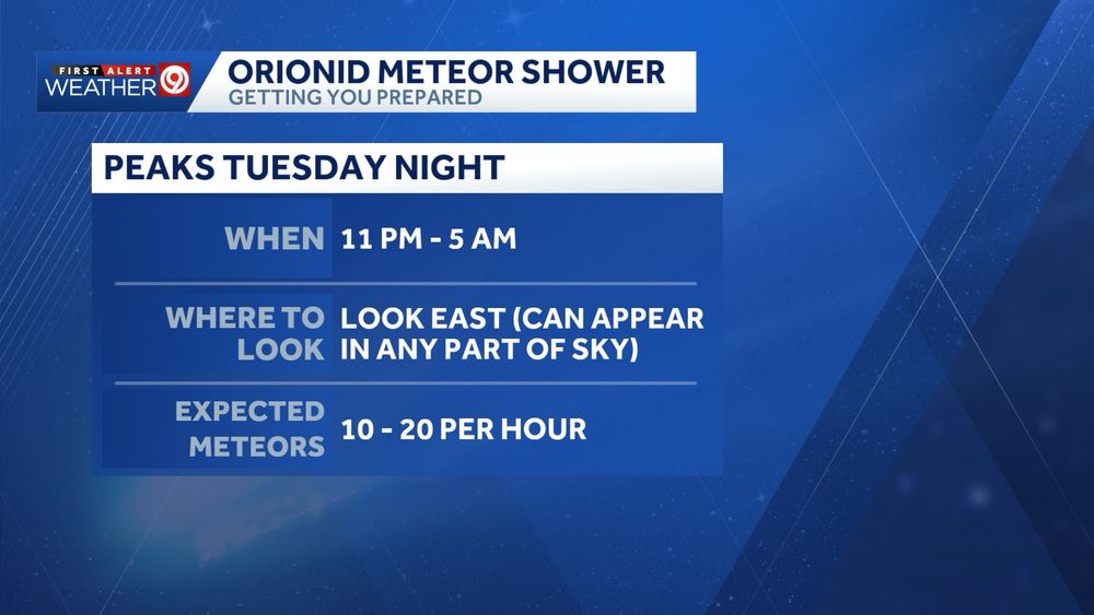
Perfect weather to check out the Comet Lemmon and the Orionid Meteor Shower (which peaks Tuesday night)! ☄️ @kmbc9.bsky.social

October 21, 2025 at 11:17 PM
Perfect weather to check out the Comet Lemmon and the Orionid Meteor Shower (which peaks Tuesday night)! ☄️ @kmbc9.bsky.social
It will feel more like fall on Tuesday with highs only in the low and mid 60s. Strong, NW wind gusts could top 35 mph during the afternoon. Areas of frost (mainly north of the Metro) are possible Wednesday morning. @kmbc9.bsky.social


October 21, 2025 at 12:36 AM
It will feel more like fall on Tuesday with highs only in the low and mid 60s. Strong, NW wind gusts could top 35 mph during the afternoon. Areas of frost (mainly north of the Metro) are possible Wednesday morning. @kmbc9.bsky.social
It is not the best night to look, but you might be able to see the Harvest Moon, which is a supermoon, between the clouds tonight. @kmbc9.bsky.social

October 7, 2025 at 2:27 AM
It is not the best night to look, but you might be able to see the Harvest Moon, which is a supermoon, between the clouds tonight. @kmbc9.bsky.social
Staying warm and getting windy this weekend. We'll start to feel more like fall next week with highs back in the 70s. kmbc.com/weather @kmbc9.bsky.social


October 4, 2025 at 2:34 AM
Staying warm and getting windy this weekend. We'll start to feel more like fall next week with highs back in the 70s. kmbc.com/weather @kmbc9.bsky.social