Ron
banner
mrwx4caster.bsky.social
Ron
@mrwx4caster.bsky.social
Atmospheric-Physicist/Professional Meteorologist in applied meteorology & forecasting in the public, private and non-profit sectors. Past President of the Canadian Meteorological and Oceanographic Society. Professional member of the AMS and RMetS (UK), AGU
Still testing the GOES Water Vapour (or Satellite Simulated WV imagery) thru model guidance,-in this case using the HRRR model to show how moisture is distributed, with brighter greens areas indicating higher moisture air Vs. darker blues/yellows areas indicating drier air.
November 11, 2025 at 3:28 AM
Need! like now 😋☕️...the sugar and caffeine boost😱🙌
November 11, 2025 at 3:06 AM
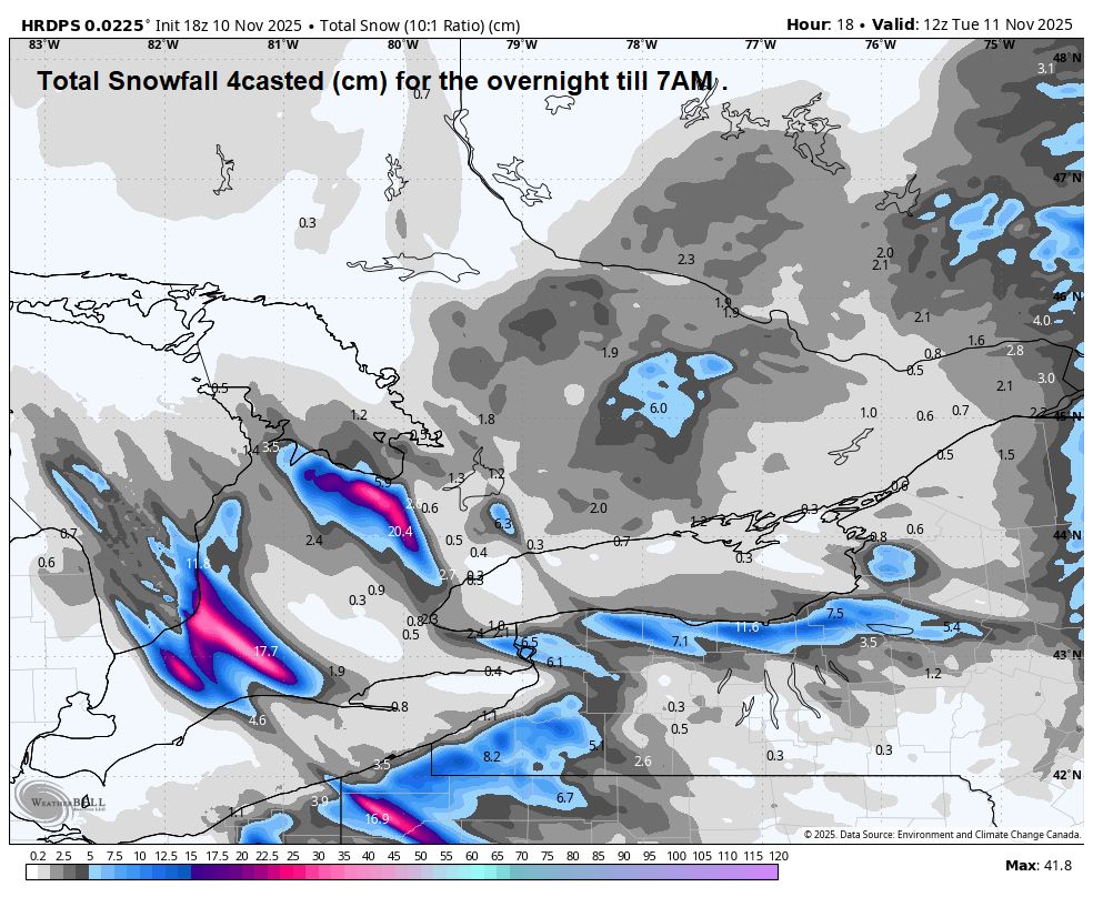
Now this is the snow estimates from the same run (see previous post) latest HRRR18 model - snowfall 4cast out to 1PM Tues. In inches-colour scale on-top. #onwx #onstorm (1" of snow=~2.5cm)
November 11, 2025 at 2:57 AM
Latest hourly run of the HRRR18 from now till 1pm Tues. Winds will back (slowly change in a counterclockwise motion) in the overnight and the LE squalls will respond, changing their orientation and altering their intensity, cause the fetch over the lakes is less. #onwx #onstorm
November 11, 2025 at 2:38 AM
Latest regional Great Lakes Radar and satellite imagery, Last six hours, till 8:42 PM EST. A few⚡️strikes noted in that squall S. L. Huron. #onwx #onstorm The contours (white lines) is the "core" of the mid-level Low...moving into S. Ontario, right-about-now.
November 11, 2025 at 1:48 AM
7am EST (12Z) Synoptic "Snapshot" of the weather for S. Ontario. #onwx #onstorm There's a plethora of ECCC alerts all relayed to the ongoing squall activity. Check the ECCC Alerts page for greater detail.
November 11, 2025 at 1:30 AM
7am EST (12Z) Synoptic "Snapshot" of the weather for N. Ontario. #onwx #onstorm
November 11, 2025 at 1:29 AM
How the latest hourly run of the HRRR18 see's things paly out over S. Ontario for the day -till Midnight. #onwx #onstorm ...gotta run🏎️
November 10, 2025 at 1:18 PM
7am EST (12Z) Synoptic "Snapshot" of the weather for S. Ontario. #onwx #onstorm Current ECCC alert as of this post. Have a great day and drive, walk, run safe! it's slippery out there.
November 10, 2025 at 1:04 PM
7am EST (12Z) Synoptic "Snapshot" of the weather for N. Ontario. #onwx #onstorm
November 10, 2025 at 1:03 PM
Ooofff...sure "feels" & "looks" wintery this morning. Latest Radar Loop/trend, last 6 hrs. till 7:05 AM EST. #onwx #onstorm
November 10, 2025 at 12:15 PM
Your upper air pattern for the week - Cold, unsettled. Plotted: the colour fill-850mb (~5k/ft. level) temps, blue=cold, black line=0C at 850mb, -white contours lines/arrows=mid level heights & wind flow. #onwx #onstorm Again, colder than normal, and unsettled overall.
November 10, 2025 at 3:43 AM
Latest HRRR48- Radar 4cast from now till Tues. 7PM, looks like another clipper? TROF? coming thru Tues. with an reinforcing shot of colder air and more snow activity🙄. Colder, unsettled week ahead, brief breaks, but upper Low/TROF in charge for most of the week. #onwx #onstorm
November 10, 2025 at 3:05 AM
Latest Great lakes Radar loop/trend, last 6 hours, till 9:35 PM EST. Another batch of backlash snows moving thru SWONT, on top of that, Snow squalls developing N to S in Lake Huron (Lambton county). Not bad for the first notable snows of the season. #onwx #onstorm
November 10, 2025 at 2:44 AM
Before I began to shovel, did a snow survey 7 PM EST (S. Sauga) 10 pokes, snow board and finally the Nipher snow gauge tube for SWE measurement. Generally ~8-9 cm (with some melting at the start of the event). SWE ~8.8mm #onwx #onstorm
November 10, 2025 at 2:21 AM
7am EST (12Z) Synoptic "Snapshot" of the weather for S. Ontario. #onwx #onstorm Once the Clipper moves off snow squalls set up in the snow belts and fresh colder air crosses them. Colder week ahead. ECCC alerts are out for snow squall development.
November 10, 2025 at 2:20 AM
Whew...heavy wet snow took longer to remove, lol
7am EST (12Z) Synoptic "Snapshot" of the weather for N. Ontario. #onwx #onstorm
November 10, 2025 at 2:19 AM
Snow squall outlook using the latest HRRR. From Midnight tonight thru to Tues. 1PM. Once Clipper #2 clears later tonight, flow behind it becomes Northerly, boom, squalls begin to develop #onwx #onstorm
November 9, 2025 at 8:50 PM
Current horizonal Visibility trend (in miles) since early this morning till 12:15 PM EST. Spot all the snow activity "with-out" radar 😅#onwx #onstorm Drive safely if you are out and about. Be safe, Stay Safe!
November 9, 2025 at 5:59 PM
Current updated Regional Radar (p-type) for Southern Ontario. Some moderate snow bands moving thru (darker shades of blue) Clipper #2 is just south of the lower lakes, SONT will remain on the colder side, with raw NE-E winds dominating most of the day. #onwx #onstorm
November 9, 2025 at 5:37 PM
Quickly then...running late....Latest Radar/Satellite loop, last 6 hours, till 8:02 AM EST. Clipper #2 continues on track for S. Ontario. Have a great day...or at least try too, lol...everyday is a gift🙏...even when covered in snow❄️. Later 👋
November 9, 2025 at 1:09 PM
7am EST (12Z) Synoptic "Snapshot" of the weather for S. Ontario. #onwx #onstorm Took the latest HRRR snow amount guidance-middle of the road-to balance other guidance. ECCC alerts remain the same from last evening. Heed them...be and stay safe. ...gotta run🚗
November 9, 2025 at 12:57 PM
7am EST (12Z) Synoptic "Snapshot" of the weather for N. Ontario. #onwx #onstorm Cold air move deeper into NEONT and the far north...and so, it begins...😕
November 9, 2025 at 12:57 PM
A closer look (via the RAP model) at that large and impressive snow squall that's currently ripping thru James Bay. it's over 400 km long. lol #onwx #onstorm
November 9, 2025 at 3:54 AM
Latest runs on "horizontal visibility"-4cast for tomorrow based on weather (my grey scale at the top -"5 miles or less"). Worked well last year to spot significant areas of reduced Visibility due to weather. From 7AM Sun thru to Mon. 7AM #onwx #onstorm Drive safe🚗...stay safe.
November 9, 2025 at 3:32 AM