


Josh Morgerman
@icyclone.bsky.social
Hardcore hurricane chaser. Mississippi transplant. Righteous Bay Rat. The #HurricaneMan. Star of series #MissionHurricane.
Happy New Year to my followers. When I’m on tough expeditions, y’all inspire me to chase harder. Thank you.
And I want to express my solidarity with Ukrainians. The strength you show defending yourselves inspires me. May we all show such bravery when evil comes our way.
Here’s to a kinder 2026.
And I want to express my solidarity with Ukrainians. The strength you show defending yourselves inspires me. May we all show such bravery when evil comes our way.
Here’s to a kinder 2026.

January 2, 2026 at 8:07 AM
Happy New Year to my followers. When I’m on tough expeditions, y’all inspire me to chase harder. Thank you.
And I want to express my solidarity with Ukrainians. The strength you show defending yourselves inspires me. May we all show such bravery when evil comes our way.
Here’s to a kinder 2026.
And I want to express my solidarity with Ukrainians. The strength you show defending yourselves inspires me. May we all show such bravery when evil comes our way.
Here’s to a kinder 2026.
Hurricane MELISSA's winds were the fiercest I've witnessed. & this is one of the highest gusts I filmed before 100% whiteout. The palm is bending so far, the crown is below the railing. This megagust happens at 43:26 in my video. Soon after, you can't see anything—just a screaming wall of whiteness.

December 20, 2025 at 2:35 AM
Hurricane MELISSA's winds were the fiercest I've witnessed. & this is one of the highest gusts I filmed before 100% whiteout. The palm is bending so far, the crown is below the railing. This megagust happens at 43:26 in my video. Soon after, you can't see anything—just a screaming wall of whiteness.
My video: Hurricane MELISSA at Ground Zero: youtu.be/siq-DdmBUIY
This is the whole story. Skip to Chapter 5 for the crazy stuff. The highest winds I’ve personally witnessed—or heard. (Screaming sound as storm peaked was harsh & painful. Folks with me held their ears.) These winds smashed concrete.
This is the whole story. Skip to Chapter 5 for the crazy stuff. The highest winds I’ve personally witnessed—or heard. (Screaming sound as storm peaked was harsh & painful. Folks with me held their ears.) These winds smashed concrete.

Hurricane MELISSA at Ground Zero (2025)
YouTube video by iCyclone
youtu.be
December 16, 2025 at 3:54 PM
My video: Hurricane MELISSA at Ground Zero: youtu.be/siq-DdmBUIY
This is the whole story. Skip to Chapter 5 for the crazy stuff. The highest winds I’ve personally witnessed—or heard. (Screaming sound as storm peaked was harsh & painful. Folks with me held their ears.) These winds smashed concrete.
This is the whole story. Skip to Chapter 5 for the crazy stuff. The highest winds I’ve personally witnessed—or heard. (Screaming sound as storm peaked was harsh & painful. Folks with me held their ears.) These winds smashed concrete.
Robust wave—Invest 98L—is entering Caribbean. While #hurricane models are not especially excited, global & AI ensembles are more aggressive, showing this system growing real fangs. Caribbean nations need to watch this one. 2025 season might go out with a bang. If it develops, it will be #MELISSA.

October 19, 2025 at 6:38 PM
Robust wave—Invest 98L—is entering Caribbean. While #hurricane models are not especially excited, global & AI ensembles are more aggressive, showing this system growing real fangs. Caribbean nations need to watch this one. 2025 season might go out with a bang. If it develops, it will be #MELISSA.
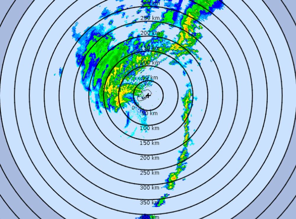
#Hurricane #IMELDA closing in on #Bermuda. Radar shows a deformed system: one super-long rainband & 1/3 of an eyewall. Ok. Strongest winds will occur within next couple of hours, I assume.
Wx Nerd Note: Many of Bermuda's stations are very high above sea level, so readings there tend to be generous.
Wx Nerd Note: Many of Bermuda's stations are very high above sea level, so readings there tend to be generous.
October 2, 2025 at 1:47 AM
#Hurricane #IMELDA closing in on #Bermuda. Radar shows a deformed system: one super-long rainband & 1/3 of an eyewall. Ok. Strongest winds will occur within next couple of hours, I assume.
Wx Nerd Note: Many of Bermuda's stations are very high above sea level, so readings there tend to be generous.
Wx Nerd Note: Many of Bermuda's stations are very high above sea level, so readings there tend to be generous.
#IMELDA ain't exactly a work of art, but it should strengthen as it accelerates ENE. Models suggest it'll be transitioning into freaky hybrid thing as it nears #Bermuda late tomorrow, but it could have spicey gusts. Me: I'm not going for this one. Ain't feeling it. Focused on the Pacific right now.

September 30, 2025 at 1:04 PM
Satellite & radar imagery show #IMELDA is starting to crank & will soon become a #hurricane off Florida, near the Bahamas. Thanks partly to #HUMBERTO, it'll accelerate away from the US—putting #Bermuda in the crosshairs. I haven't decided my next step—weighing potential targets around the world.

September 29, 2025 at 10:22 PM
Satellite & radar imagery show #IMELDA is starting to crank & will soon become a #hurricane off Florida, near the Bahamas. Thanks partly to #HUMBERTO, it'll accelerate away from the US—putting #Bermuda in the crosshairs. I haven't decided my next step—weighing potential targets around the world.
Final leg of my grand odyssey to hunt #Typhoon RAGASA in China: quickie dusk flight from Houston to Gulfport. I was deep in thought the whole time about one thing: what I'm hunting next. French Quarter of New Orleans shimmered down below. Hurricane House seemed to welcome me home as I pulled up. ♥️


September 28, 2025 at 12:31 PM
Final leg of my grand odyssey to hunt #Typhoon RAGASA in China: quickie dusk flight from Houston to Gulfport. I was deep in thought the whole time about one thing: what I'm hunting next. French Quarter of New Orleans shimmered down below. Hurricane House seemed to welcome me home as I pulled up. ♥️
Yeah, it looks sexy. But I'm not gonna sit here oohing and aahing over fish food all day. Ain't my style. P.S. Despite the "quiet" season, Cat-4 #Hurricane #HUMBERTO is the third top-quality specimen in the Atlantic this year.

September 27, 2025 at 6:57 PM
Yeah, it looks sexy. But I'm not gonna sit here oohing and aahing over fish food all day. Ain't my style. P.S. Despite the "quiet" season, Cat-4 #Hurricane #HUMBERTO is the third top-quality specimen in the Atlantic this year.
NHC has started advisories on the thing which will soon be #IMELDA. Models are giving mixed signals in terms of intensity & path, with other pieces on the chessboard being the trough over the US & Hurricane HUMBERTO in Atlantic. Main takeaway: possible #hurricane near Southeast US coast by Tuesday.

September 26, 2025 at 9:49 PM
NHC has started advisories on the thing which will soon be #IMELDA. Models are giving mixed signals in terms of intensity & path, with other pieces on the chessboard being the trough over the US & Hurricane HUMBERTO in Atlantic. Main takeaway: possible #hurricane near Southeast US coast by Tuesday.
My fixer Mr. Chen & me, the day after the typhoon—in his hometown of Foshan in Guangdong. He wanted to take me to lunch at his favorite neighborhood place. We worked well together. We had to communicate entirely thru translation apps, but we made it work. And, yes, he said he'd do it again! 谢谢陈先生!

September 26, 2025 at 9:45 PM
My fixer Mr. Chen & me, the day after the typhoon—in his hometown of Foshan in Guangdong. He wanted to take me to lunch at his favorite neighborhood place. We worked well together. We had to communicate entirely thru translation apps, but we made it work. And, yes, he said he'd do it again! 谢谢陈先生!
Recovering from a brutal chase. My 82nd core penetration did not come easy, but it did come. Got into eye of #Typhoon #RAGASA on Hailing Island China 6 pm Wednesday. Storm was decaying but violent. Eyewall was gusty, explosive, micobursty. Lots of damage to hotel & trees. Now en route back to US.
September 26, 2025 at 9:41 PM
Cat-5 Super #Typhoon #RAGASA raking the Babuyan Islands of the #Philippines with winds of 145 knots. Babuyan Island is squarely in the eye; the larger & more populated Calayan Island is in the inner eyewall—no doubt seeing extreme winds—& about to enter the lull. Next stop for me: China.

September 22, 2025 at 5:10 AM
Cat-5 Super #Typhoon #RAGASA raking the Babuyan Islands of the #Philippines with winds of 145 knots. Babuyan Island is squarely in the eye; the larger & more populated Calayan Island is in the inner eyewall—no doubt seeing extreme winds—& about to enter the lull. Next stop for me: China.
Night falls on #Philippines as Cat-5 Super #Typhoon #RAGASA heads for Luzon Strait—a place that's seen many such beasts. After it clears the Strait, a weaker RAGASA will threaten big population centers in China. Me: hanging in Manila. I've made no decision where I'm going to hunt. There's time.

September 21, 2025 at 10:59 AM
Night falls on #Philippines as Cat-5 Super #Typhoon #RAGASA heads for Luzon Strait—a place that's seen many such beasts. After it clears the Strait, a weaker RAGASA will threaten big population centers in China. Me: hanging in Manila. I've made no decision where I'm going to hunt. There's time.
#Typhoon #RAGASA is gorgeous—& difficult to chase. My target was Babuyan Islands (orange). There's no airport, but I had a plan—& then the plan fell through. Plan B: Hunt it in China (pink), where it could be a big impact. My possible targets: Hong Kong, Macau, Zhanjiang, & Leizhou. No decision yet.

September 21, 2025 at 2:09 AM
#Typhoon #RAGASA is gorgeous—& difficult to chase. My target was Babuyan Islands (orange). There's no airport, but I had a plan—& then the plan fell through. Plan B: Hunt it in China (pink), where it could be a big impact. My possible targets: Hong Kong, Macau, Zhanjiang, & Leizhou. No decision yet.
P.S. Sorry I've been silent for a while. Bluesky isn't available in Mississippi due to some age-verification bullsh*t, and I haven't gotten around to setting up a VPN.
September 20, 2025 at 3:23 AM
P.S. Sorry I've been silent for a while. Bluesky isn't available in Mississippi due to some age-verification bullsh*t, and I haven't gotten around to setting up a VPN.
Hey from 35K ft over Pacific. I'm on the journey to hunt down #Typhoon #RAGASA. My plan: there ain't no plan—yet. Too soon. I'm just gonna land in Manila & look at it. From there, I have six distinct paths I can take—across different nations, etc. This is a tricky one. WPAC always a pain in the ass.


September 20, 2025 at 3:21 AM
Hey from 35K ft over Pacific. I'm on the journey to hunt down #Typhoon #RAGASA. My plan: there ain't no plan—yet. Too soon. I'm just gonna land in Manila & look at it. From there, I have six distinct paths I can take—across different nations, etc. This is a tricky one. WPAC always a pain in the ass.
#ERIN: big, powerful #hurricane that'll stay out over Atlantic. However, it'll grow in size—typical as hurricanes move N—so parts of US East Coast will see gusty winds & coastal flooding—like NC's Outer Banks. Re: next Atlantic wave: I'm starting to get a fishy, briny scent from that one, too.

August 19, 2025 at 1:40 AM
#ERIN: big, powerful #hurricane that'll stay out over Atlantic. However, it'll grow in size—typical as hurricanes move N—so parts of US East Coast will see gusty winds & coastal flooding—like NC's Outer Banks. Re: next Atlantic wave: I'm starting to get a fishy, briny scent from that one, too.
Reposted by Josh Morgerman

Two-sided perspective box, 1670. When seen through a peep-hole, the scene becomes an illusionistic 3-D room, w/ table set for tea, and artworks displayed on wallspace. Nice! By Pieter Janssens Elinga, born OTD 1623.

August 18, 2025 at 1:00 PM
Two-sided perspective box, 1670. When seen through a peep-hole, the scene becomes an illusionistic 3-D room, w/ table set for tea, and artworks displayed on wallspace. Nice! By Pieter Janssens Elinga, born OTD 1623.
Fifty-six years ago tonight, Category-5 #Hurricane #CAMILLE smashed #Mississippi. Eye passed right over my town, Bay Saint Louis. Community was devastated. I've been documenting the oral histories of neighbors who survived it. Check out their accounts here: www.facebook.com/share/p/1EfY...


August 18, 2025 at 12:17 AM
Fifty-six years ago tonight, Category-5 #Hurricane #CAMILLE smashed #Mississippi. Eye passed right over my town, Bay Saint Louis. Community was devastated. I've been documenting the oral histories of neighbors who survived it. Check out their accounts here: www.facebook.com/share/p/1EfY...
Pic from Hurricane Hunters' mission into #Hurricane #ERIN. Spectacular stadium eye. ❤ But I've moved on from ERIN. It's over between us. I'm a chaserdude—so if I can't have it, I'm not into it. Ain't gonna oooh & aaah over sexy fish food. My new focus? Possible rebound romance models are hinting at.

August 17, 2025 at 6:08 AM
Pic from Hurricane Hunters' mission into #Hurricane #ERIN. Spectacular stadium eye. ❤ But I've moved on from ERIN. It's over between us. I'm a chaserdude—so if I can't have it, I'm not into it. Ain't gonna oooh & aaah over sexy fish food. My new focus? Possible rebound romance models are hinting at.
San Juan radar shows #Hurricane #ERIN's tight core passing well N of #PuertoRico. Even so, outer rainbands are bringing heavy rain & gusty winds to PR & Virgin Islands. That inner core may collapse & give way to new, larger core—a classic eyewall replacement cycle. Either way, ERIN will miss US.

August 17, 2025 at 6:02 AM
San Juan radar shows #Hurricane #ERIN's tight core passing well N of #PuertoRico. Even so, outer rainbands are bringing heavy rain & gusty winds to PR & Virgin Islands. That inner core may collapse & give way to new, larger core—a classic eyewall replacement cycle. Either way, ERIN will miss US.
Say hey to #ERIN, first #hurricane of the Atlantic season, passing just NE of Puerto Rico & Virgin Islands. It's now a Cat 5, with winds of 140 knots. Check out that sexy pinhole eye. Fortunately, this monstruous specimen is fish food—taking the perfect path, "field goaling" between all landmasses.

August 16, 2025 at 4:38 PM
Say hey to #ERIN, first #hurricane of the Atlantic season, passing just NE of Puerto Rico & Virgin Islands. It's now a Cat 5, with winds of 140 knots. Check out that sexy pinhole eye. Fortunately, this monstruous specimen is fish food—taking the perfect path, "field goaling" between all landmasses.
TS #ERIN is looking much healthier. It's increasingly feeling like a fish storm, with models suggesting it may "field goal" between landmasses—N of Caribbean islands, E of Bahamas, between US & Bermuda, then S of Atlantic Canada. But outliers threaten E Bahamas, Newfoundland, & Bermuda.

August 14, 2025 at 12:27 PM
TS #ERIN is looking much healthier. It's increasingly feeling like a fish storm, with models suggesting it may "field goal" between landmasses—N of Caribbean islands, E of Bahamas, between US & Bermuda, then S of Atlantic Canada. But outliers threaten E Bahamas, Newfoundland, & Bermuda.