


Holden LeCroy
@holdenlecroy.bsky.social
Weather + Outdoors. #SCnative turned #Oregonian. KEZI-9 Chief Meteorologist. Christian, hiker, runner, likes coffee, talks science.


February 5, 2025 at 4:37 PM


❄️⚡️WILLAMETTE VALLEY & OREGON COAST: Things could get interesting tonight... we're expecting the development of a convective line of snow showers... this same area of low pressure moving in has had a history of producing snow in Western WA. Could see a good dusting to 1" #ORwx #Oregon #Portland


February 4, 2025 at 11:42 PM
Foothills (including Oakridge and Mckenzie) additional 1-inch.
Valley (including Eugene, Portland and Roseburg) Dusting to half-inch. #ORwx
Valley (including Eugene, Portland and Roseburg) Dusting to half-inch. #ORwx
February 4, 2025 at 11:41 PM
Foothills (including Oakridge and Mckenzie) additional 1-inch.
Valley (including Eugene, Portland and Roseburg) Dusting to half-inch. #ORwx
Valley (including Eugene, Portland and Roseburg) Dusting to half-inch. #ORwx


❄️Back edge of snow is winding down for Southern Oregon and we are expecting a bit of a break for pretty much everyone on Tuesday. Except Klamath Falls and Siskiyou County.
Wednesday, Thursday will bring the chance of scattered snow for Willamette (LIGHT ACCUM.) #ORwx #Oregon
Wednesday, Thursday will bring the chance of scattered snow for Willamette (LIGHT ACCUM.) #ORwx #Oregon

February 4, 2025 at 2:56 AM


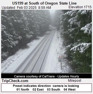
SOUTHERN OREGON SNOW
❄️⚠️Medford Schools, Central Point early dismissal starts at 11:30 AM... About 2 inches in Medford, 4 inches in Ashland and upwards of 12" in Klamath Falls. Snow will continue until 11PM tonight for Medford, 8PM Tuesday for Klamath. #ORwx #Oregon #snOMG
❄️⚠️Medford Schools, Central Point early dismissal starts at 11:30 AM... About 2 inches in Medford, 4 inches in Ashland and upwards of 12" in Klamath Falls. Snow will continue until 11PM tonight for Medford, 8PM Tuesday for Klamath. #ORwx #Oregon #snOMG

February 3, 2025 at 7:26 PM
❄️Snow has not let up, will not let up for #KlamathFalls until Wednesday (NOW 10-inches)... meanwhile atmospheric river has finally pivoted back northwest providing snow for Medford area through 11PM tonight. #ORwx #snOMG


February 3, 2025 at 5:29 PM
❄️Snow has not let up, will not let up for #KlamathFalls until Wednesday (NOW 10-inches)... meanwhile atmospheric river has finally pivoted back northwest providing snow for Medford area through 11PM tonight. #ORwx #snOMG


❄️Valley snow chances are good next week, but amounts are not good.
Very dry, upper low will swing through and precipitation will be VERY scattered. Things could change, but we NEED MORE moisture. Dusting possible each and every morning next week and that's about it. #ORwx #Oregon
Very dry, upper low will swing through and precipitation will be VERY scattered. Things could change, but we NEED MORE moisture. Dusting possible each and every morning next week and that's about it. #ORwx #Oregon

January 30, 2025 at 11:50 PM
🌪️Multiple waterspouts over and around Kauai this morning, vertical profile indicates some incredibly cold air, slight shear with height capable of producing multiple supercells here in the past hour. Same storm will bring snow to Mauna Kea and Mauna Loa Friday. #Hawaii

January 30, 2025 at 5:49 PM
🌪️Multiple waterspouts over and around Kauai this morning, vertical profile indicates some incredibly cold air, slight shear with height capable of producing multiple supercells here in the past hour. Same storm will bring snow to Mauna Kea and Mauna Loa Friday. #Hawaii
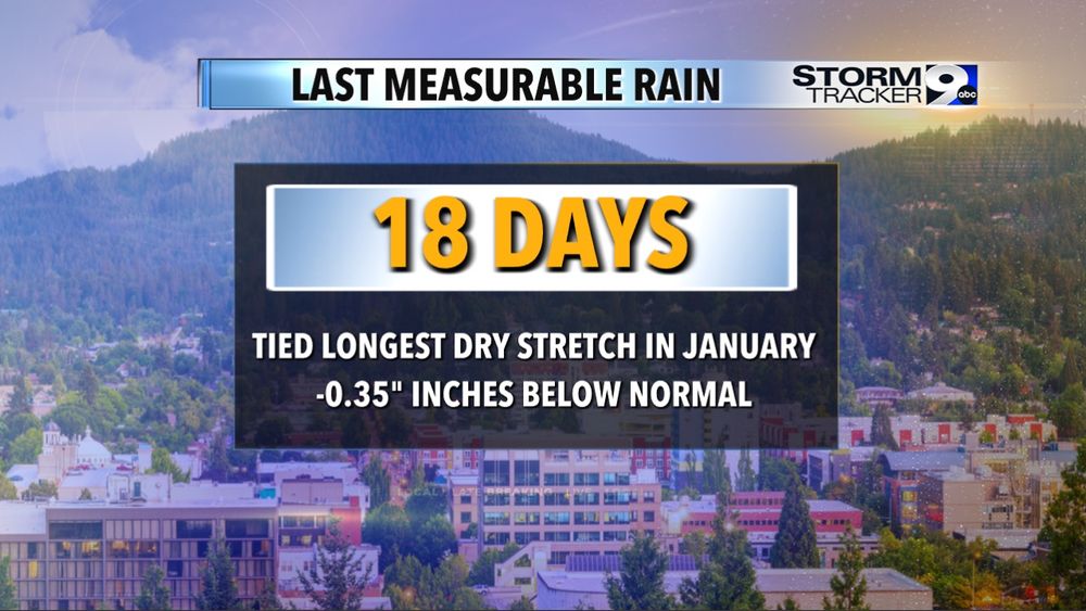
Last bit of sunshine until... well not sure yet. Thing is we turn one of our driest stretches in January ever (18 DAYS) into a significantly wet pattern starting Thursday night.
Storm is strengthening, tapping into moisture set to bring an Atmospheric River FIRST... #ORwx
Storm is strengthening, tapping into moisture set to bring an Atmospheric River FIRST... #ORwx


January 30, 2025 at 1:49 AM
Last bit of sunshine until... well not sure yet. Thing is we turn one of our driest stretches in January ever (18 DAYS) into a significantly wet pattern starting Thursday night.
Storm is strengthening, tapping into moisture set to bring an Atmospheric River FIRST... #ORwx
Storm is strengthening, tapping into moisture set to bring an Atmospheric River FIRST... #ORwx
❄️Periods of snow/ice down to as low as 300 feet possible from Monday night, February 3 to Saturday, February 8. Not a guarantee, but now is a good time to plan ahead!
Yes, Oregon is use to snow at high elevations but resources (plows, de-icer) could be stretched thin. #ORwx
Yes, Oregon is use to snow at high elevations but resources (plows, de-icer) could be stretched thin. #ORwx

January 28, 2025 at 6:58 PM
❄️Periods of snow/ice down to as low as 300 feet possible from Monday night, February 3 to Saturday, February 8. Not a guarantee, but now is a good time to plan ahead!
Yes, Oregon is use to snow at high elevations but resources (plows, de-icer) could be stretched thin. #ORwx
Yes, Oregon is use to snow at high elevations but resources (plows, de-icer) could be stretched thin. #ORwx
Winter fire danger? Yes, high pressure over central Oregon is building this weekend. Many communities will experience east winds, but thankfully we're in winter not summer. Humidity doesn't drop below 40% and winds don't exceed 35 MPH.
🔥WATCH BURN PILES, BURN IN MORNING. #ORwx
🔥WATCH BURN PILES, BURN IN MORNING. #ORwx

January 25, 2025 at 12:59 AM
Winter fire danger? Yes, high pressure over central Oregon is building this weekend. Many communities will experience east winds, but thankfully we're in winter not summer. Humidity doesn't drop below 40% and winds don't exceed 35 MPH.
🔥WATCH BURN PILES, BURN IN MORNING. #ORwx
🔥WATCH BURN PILES, BURN IN MORNING. #ORwx