


Fumihiko Ikegami
@fikgm.bsky.social
Earth Science Watcher in Japan. Master of Geology and None. I am myself, not employers.
Pinned

I wrote this article in Japanese back in the New Year and now it is also available in English at my substack. I hope some people find it useful.
January 14, 2026 at 9:04 AM
I wrote this article in Japanese back in the New Year and now it is also available in English at my substack. I hope some people find it useful.
Links to Geology-related Open GIS Data
open.substack.com/pub/ikegami/...
open.substack.com/pub/ikegami/...

January 14, 2026 at 9:03 AM
Links to Geology-related Open GIS Data
open.substack.com/pub/ikegami/...
open.substack.com/pub/ikegami/...
What happens in my mind when I "read" the topographical contours.
1→2. Compute the Slope (Focus onto the dense-sparse of the contour lines).
2→3. Integrate the Structure (Track the ridges and valleys).
3→4. Synthesize the Terrain. (Overlaying data to build the 3D mental model.)
1→2. Compute the Slope (Focus onto the dense-sparse of the contour lines).
2→3. Integrate the Structure (Track the ridges and valleys).
3→4. Synthesize the Terrain. (Overlaying data to build the 3D mental model.)


January 14, 2026 at 7:50 AM
What happens in my mind when I "read" the topographical contours.
1→2. Compute the Slope (Focus onto the dense-sparse of the contour lines).
2→3. Integrate the Structure (Track the ridges and valleys).
3→4. Synthesize the Terrain. (Overlaying data to build the 3D mental model.)
1→2. Compute the Slope (Focus onto the dense-sparse of the contour lines).
2→3. Integrate the Structure (Track the ridges and valleys).
3→4. Synthesize the Terrain. (Overlaying data to build the 3D mental model.)
Million years of geology in Ryukyu Islands, explained in single image.

January 14, 2026 at 6:00 AM
Million years of geology in Ryukyu Islands, explained in single image.
A magnificent ocean sediment transport from Yangtze River to Okinawa Trough is seen today. It is probably due to the strong westerly seasonal wind these days.
weather-models.info/latest/himaw...
weather-models.info/latest/himaw...


January 14, 2026 at 5:40 AM
A magnificent ocean sediment transport from Yangtze River to Okinawa Trough is seen today. It is probably due to the strong westerly seasonal wind these days.
weather-models.info/latest/himaw...
weather-models.info/latest/himaw...
Seismotectonics of Hokkaido, the collisional area between NE Japan and Kuril arcs.
GEBCO, AW3D30, GSHHG, GlobalCMT (M>4, 1991-2020), Uchide (2022)(GSJ, AIST), JMA Unified Hypocenters (1998-2021, D<20 km), Seamless Geological Map (GSJ, AIST), Volcanoes and Calderas (GSJ, AIST)
GEBCO, AW3D30, GSHHG, GlobalCMT (M>4, 1991-2020), Uchide (2022)(GSJ, AIST), JMA Unified Hypocenters (1998-2021, D<20 km), Seamless Geological Map (GSJ, AIST), Volcanoes and Calderas (GSJ, AIST)


January 13, 2026 at 2:25 AM
Seismotectonics of Hokkaido, the collisional area between NE Japan and Kuril arcs.
GEBCO, AW3D30, GSHHG, GlobalCMT (M>4, 1991-2020), Uchide (2022)(GSJ, AIST), JMA Unified Hypocenters (1998-2021, D<20 km), Seamless Geological Map (GSJ, AIST), Volcanoes and Calderas (GSJ, AIST)
GEBCO, AW3D30, GSHHG, GlobalCMT (M>4, 1991-2020), Uchide (2022)(GSJ, AIST), JMA Unified Hypocenters (1998-2021, D<20 km), Seamless Geological Map (GSJ, AIST), Volcanoes and Calderas (GSJ, AIST)
Dear US citizens, we can't wait another 3 years for you to fix your government.
January 3, 2026 at 3:22 PM
Dear US citizens, we can't wait another 3 years for you to fix your government.
And in case if you prefer easy vector contours in one file, use this geopackage file I made.
drive.google.com/file/d/1wSZd...
drive.google.com/file/d/1wSZd...
Slab2_Depth_Contours_World_10km_Wrapped180.gpkg
drive.google.com
December 30, 2025 at 5:50 AM
And in case if you prefer easy vector contours in one file, use this geopackage file I made.
drive.google.com/file/d/1wSZd...
drive.google.com/file/d/1wSZd...
The download page of USGS's slab2 dataset looks gone.
www.usgs.gov/data/slab2-a...
Here is the alternative download link. I downloaded it in May.
drive.google.com/file/d/1lrP1...
www.usgs.gov/data/slab2-a...
Here is the alternative download link. I downloaded it in May.
drive.google.com/file/d/1lrP1...

December 30, 2025 at 5:48 AM
The download page of USGS's slab2 dataset looks gone.
www.usgs.gov/data/slab2-a...
Here is the alternative download link. I downloaded it in May.
drive.google.com/file/d/1lrP1...
www.usgs.gov/data/slab2-a...
Here is the alternative download link. I downloaded it in May.
drive.google.com/file/d/1lrP1...
JAMSTEC R/V Kaimei is livestreaming from Mariana's NW Rota-1 volcano right now...
www.youtube.com/live/hIb3QTz...
www.youtube.com/live/hIb3QTz...


December 26, 2025 at 5:44 AM
JAMSTEC R/V Kaimei is livestreaming from Mariana's NW Rota-1 volcano right now...
www.youtube.com/live/hIb3QTz...
www.youtube.com/live/hIb3QTz...
Geological Survey of Japan has released the raw drone videos of the eruption of Shinmoedake back in July.
storage.repository.aist.go.jp/1104/index.h...
DJI_20250703140503 has the footage of the most intense part of the eruption.
storage.repository.aist.go.jp/1104/index.h...
DJI_20250703140503 has the footage of the most intense part of the eruption.

December 22, 2025 at 10:10 AM
Geological Survey of Japan has released the raw drone videos of the eruption of Shinmoedake back in July.
storage.repository.aist.go.jp/1104/index.h...
DJI_20250703140503 has the footage of the most intense part of the eruption.
storage.repository.aist.go.jp/1104/index.h...
DJI_20250703140503 has the footage of the most intense part of the eruption.
Same igneous bodies but in a different form. Not far from the previous outcrop.


December 21, 2025 at 8:07 AM
Same igneous bodies but in a different form. Not far from the previous outcrop.
Igneous mafic-silicic something. Don't ask me what was happened here in 120 Ma tonalite. Shikanoshima, Fukuoka, Japan.


December 21, 2025 at 8:04 AM
Igneous mafic-silicic something. Don't ask me what was happened here in 120 Ma tonalite. Shikanoshima, Fukuoka, Japan.
I am pretty impressed to Gemini 3. It is the first AI I am scared of. We dont probably need human researchers to find a scientific question anymore. Only lab rats and field explorers will survive this major extinction. Good luck.
November 21, 2025 at 6:55 AM
I am pretty impressed to Gemini 3. It is the first AI I am scared of. We dont probably need human researchers to find a scientific question anymore. Only lab rats and field explorers will survive this major extinction. Good luck.
Meanwhile, people in the area is advised to be prepared. Even JMA mentions the possibility of an even larger earthquake in the next few days (which advice is based on the past events like 1992 in the region).
www.jma-net.go.jp/morioka/jish...
www.jma-net.go.jp/morioka/jish...
www.jma-net.go.jp
November 11, 2025 at 1:59 AM
Meanwhile, people in the area is advised to be prepared. Even JMA mentions the possibility of an even larger earthquake in the next few days (which advice is based on the past events like 1992 in the region).
www.jma-net.go.jp/morioka/jish...
www.jma-net.go.jp/morioka/jish...
I really really wish everyone in the subduction zone around the world has this. It is the best thing that Japan has developed in the past decades.
November 11, 2025 at 1:49 AM
I really really wish everyone in the subduction zone around the world has this. It is the best thing that Japan has developed in the past decades.
It could be the sort of aftershocks, but some seismologists speculate that the event (which is the part of an earthquake swarm) is the part of a M8-class slow slip event which also happened in the region in 1992. The area is historically very active.
November 11, 2025 at 1:46 AM
It could be the sort of aftershocks, but some seismologists speculate that the event (which is the part of an earthquake swarm) is the part of a M8-class slow slip event which also happened in the region in 1992. The area is historically very active.
The underwater seismometer network is so great, as evidenced from yesterday's EQ off-Tohoku.
Reposting unofficial visualization by x.com/kotoho76/sta...
Reposting unofficial visualization by x.com/kotoho76/sta...
November 10, 2025 at 6:56 AM
The underwater seismometer network is so great, as evidenced from yesterday's EQ off-Tohoku.
Reposting unofficial visualization by x.com/kotoho76/sta...
Reposting unofficial visualization by x.com/kotoho76/sta...
Japan Coast Guard found no significant bathymetric change after the earthquake swarm in Tokara Islands. The mystery deepens...
www.kaiho.mlit.go.jp/info/kouhou/...
www.kaiho.mlit.go.jp/info/kouhou/...

トカラ列島周辺海域にて地震後初の海底地形調査を実施~地震活動の原因解明に資する基礎情報としての活用が期待~|海上保安庁
発表日 令和7年9月8日 概要 海上保安庁海洋情報部は、活発な地震活動が発生し...
www.kaiho.mlit.go.jp
September 13, 2025 at 9:22 AM
Japan Coast Guard found no significant bathymetric change after the earthquake swarm in Tokara Islands. The mystery deepens...
www.kaiho.mlit.go.jp/info/kouhou/...
www.kaiho.mlit.go.jp/info/kouhou/...
Updates from JMA regarding the eruption of Iwojima (Ogasawara Io-to).
www.data.jma.go.jp/vois/data/re...
www.data.jma.go.jp/vois/data/re...

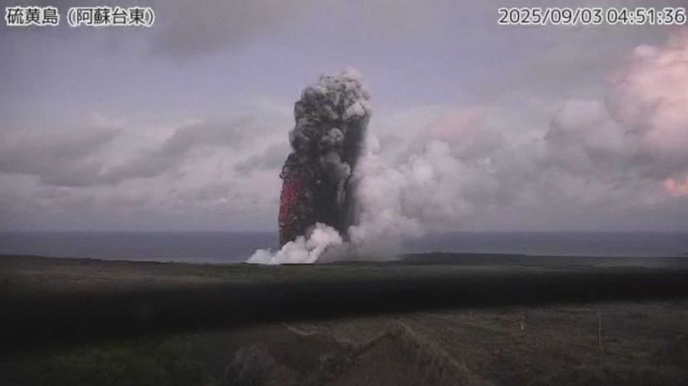


September 8, 2025 at 5:03 AM
Updates from JMA regarding the eruption of Iwojima (Ogasawara Io-to).
www.data.jma.go.jp/vois/data/re...
www.data.jma.go.jp/vois/data/re...
Thanks. Probably this concides to the seismicity uptick in the island in the recent days...
September 2, 2025 at 5:23 AM
Thanks. Probably this concides to the seismicity uptick in the island in the recent days...
JMA reported Iwojima (Ogasawara Io-to) is erupting.
Image from Himawari-9 satellite. weather-models.info/latest/himaw...
Image from Himawari-9 satellite. weather-models.info/latest/himaw...

September 2, 2025 at 5:02 AM
JMA reported Iwojima (Ogasawara Io-to) is erupting.
Image from Himawari-9 satellite. weather-models.info/latest/himaw...
Image from Himawari-9 satellite. weather-models.info/latest/himaw...
I think so. The EQ has been studied intensively.
September 1, 2025 at 10:11 AM
I think so. The EQ has been studied intensively.
The map was made by the 4 years levelling campaign with >4000 people・days... Crazy stuff.
September 1, 2025 at 1:20 AM
The map was made by the 4 years levelling campaign with >4000 people・days... Crazy stuff.
Today is the National Disaster Prevention Day in Japan, commemorating the 1923 Great Kanto Earthquake which devastated Tokyo and Yokohama.
Here is the ground displacements map after the EQ, which was of course made without GPS or InSAR...
www.gsi.go.jp/kohokocho/ko...
Here is the ground displacements map after the EQ, which was of course made without GPS or InSAR...
www.gsi.go.jp/kohokocho/ko...

September 1, 2025 at 1:15 AM
Today is the National Disaster Prevention Day in Japan, commemorating the 1923 Great Kanto Earthquake which devastated Tokyo and Yokohama.
Here is the ground displacements map after the EQ, which was of course made without GPS or InSAR...
www.gsi.go.jp/kohokocho/ko...
Here is the ground displacements map after the EQ, which was of course made without GPS or InSAR...
www.gsi.go.jp/kohokocho/ko...