


Dominik Weckmüller
@domegis.bsky.social
GIS, Geo Data Science, GeoAI, LLMs & NLP
Democratizing Geodata & Tools
Democratizing Geodata & Tools
Pinned
Dominik Weckmüller
@domegis.bsky.social
· Jul 22
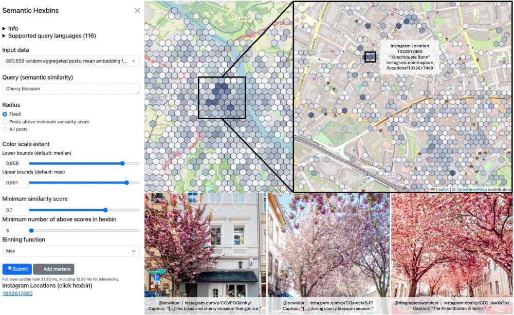
Paper Alert!
"Embedding-Based Multilingual Semantic Search for Geo-Textual Data in Urban Studies," is published in @springernature.com
I developed an open-source, lightweight method to map phenomena using natural language, like "cherry blossom spots" or "skate parks" with VGI. Demos:
geo.rocks/gss
"Embedding-Based Multilingual Semantic Search for Geo-Textual Data in Urban Studies," is published in @springernature.com
I developed an open-source, lightweight method to map phenomena using natural language, like "cherry blossom spots" or "skate parks" with VGI. Demos:
geo.rocks/gss
@overturemaps.bsky.social now offers a STAC catalogue with all their datasets! The best part: every dataset is now also released as pmtiles file you can query on the spot in your browser!
Browser: radiantearth.github.io/stac-browser...
Pmtiles example: pmtiles.io#url=https%3A...
Check it out!
Browser: radiantearth.github.io/stac-browser...
Pmtiles example: pmtiles.io#url=https%3A...
Check it out!

February 4, 2026 at 10:48 PM
@overturemaps.bsky.social now offers a STAC catalogue with all their datasets! The best part: every dataset is now also released as pmtiles file you can query on the spot in your browser!
Browser: radiantearth.github.io/stac-browser...
Pmtiles example: pmtiles.io#url=https%3A...
Check it out!
Browser: radiantearth.github.io/stac-browser...
Pmtiles example: pmtiles.io#url=https%3A...
Check it out!
Apple built the most powerful browser-based open source GIS without even intending it. I forked their Embedding-Atlas, added @maplibre.org support and now you have a WebGPU-ready GIS, table, graph and SQL support for 100M datasets!
Have a look: github.com/do-me/geospa...
@webgpu.bsky.social #gischat
Have a look: github.com/do-me/geospa...
@webgpu.bsky.social #gischat


December 30, 2025 at 6:10 PM
Apple built the most powerful browser-based open source GIS without even intending it. I forked their Embedding-Atlas, added @maplibre.org support and now you have a WebGPU-ready GIS, table, graph and SQL support for 100M datasets!
Have a look: github.com/do-me/geospa...
@webgpu.bsky.social #gischat
Have a look: github.com/do-me/geospa...
@webgpu.bsky.social #gischat
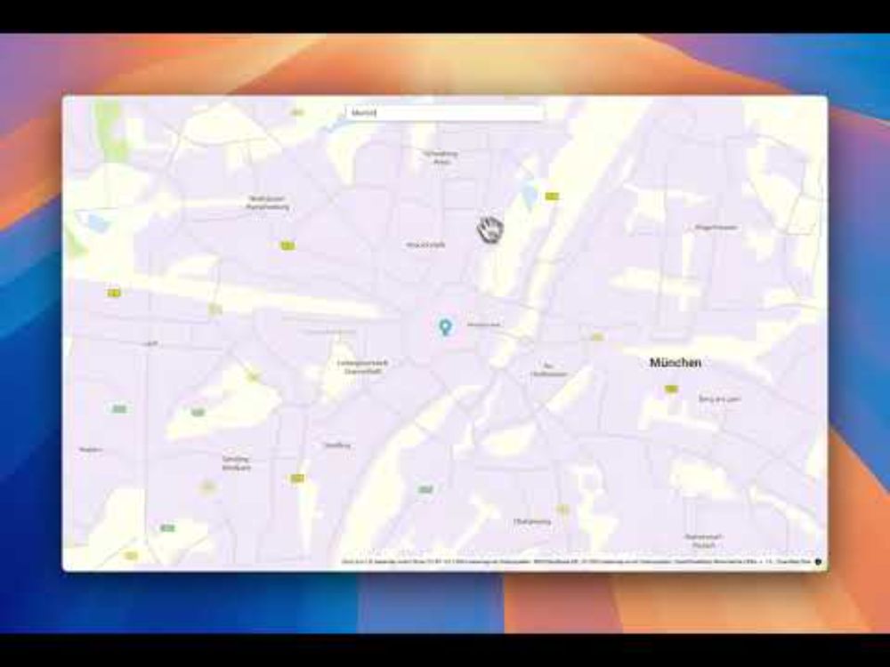
#30DayMapChallenge - Day 17: A new tool - A new GIS!
The most efficient in-browser GIS in 2025 is Embedding Atlas from Apple and built with @duckdb.org. Originally designed to visualize embeddings it makes for a great GIS! Loading 21M addresses: zoom & pan smoothly
www.linkedin.com/feed/update/...
The most efficient in-browser GIS in 2025 is Embedding Atlas from Apple and built with @duckdb.org. Originally designed to visualize embeddings it makes for a great GIS! Loading 21M addresses: zoom & pan smoothly
www.linkedin.com/feed/update/...

#30daymapchallenge | Dominik Weckmüller | 11 comments
#30DayMapChallenge - Day 17: A new tool - A new GIS!
It turns out the most efficient in-browser GIS in 2025 is Embedding Atlas from Apple and built with - you guess it - DuckDB! The tool was originall...
www.linkedin.com
November 19, 2025 at 5:48 PM
#30DayMapChallenge - Day 17: A new tool - A new GIS!
The most efficient in-browser GIS in 2025 is Embedding Atlas from Apple and built with @duckdb.org. Originally designed to visualize embeddings it makes for a great GIS! Loading 21M addresses: zoom & pan smoothly
www.linkedin.com/feed/update/...
The most efficient in-browser GIS in 2025 is Embedding Atlas from Apple and built with @duckdb.org. Originally designed to visualize embeddings it makes for a great GIS! Loading 21M addresses: zoom & pan smoothly
www.linkedin.com/feed/update/...
#30DayMapChallenge Day 7: Accessibility
Built something special for this year's challenge: GeoParquet Visualizer, a browser-based tool to explore and share your maps easily.
Free, open source & super lightweight.
App: do-me.github.io/geoparquet-v...
GitHub: github.com/do-me/geopar...
#gischat
Built something special for this year's challenge: GeoParquet Visualizer, a browser-based tool to explore and share your maps easily.
Free, open source & super lightweight.
App: do-me.github.io/geoparquet-v...
GitHub: github.com/do-me/geopar...
#gischat

November 7, 2025 at 1:32 PM
#30DayMapChallenge Day 7: Accessibility
Built something special for this year's challenge: GeoParquet Visualizer, a browser-based tool to explore and share your maps easily.
Free, open source & super lightweight.
App: do-me.github.io/geoparquet-v...
GitHub: github.com/do-me/geopar...
#gischat
Built something special for this year's challenge: GeoParquet Visualizer, a browser-based tool to explore and share your maps easily.
Free, open source & super lightweight.
App: do-me.github.io/geoparquet-v...
GitHub: github.com/do-me/geopar...
#gischat
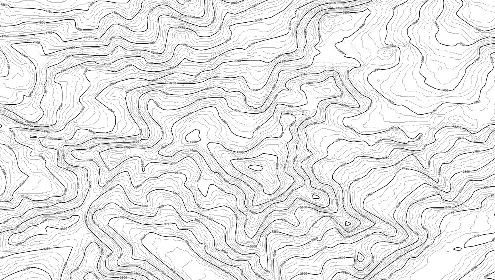
You can use three.js as GIS to render contour lines from a Geotiff with customizable labels! Work in progress.
(P.S. can you tell where this might be? ;) ) #gischat
(P.S. can you tell where this might be? ;) ) #gischat
July 25, 2025 at 2:35 PM
You can use three.js as GIS to render contour lines from a Geotiff with customizable labels! Work in progress.
(P.S. can you tell where this might be? ;) ) #gischat
(P.S. can you tell where this might be? ;) ) #gischat
Paper Alert!
"Embedding-Based Multilingual Semantic Search for Geo-Textual Data in Urban Studies," is published in @springernature.com
I developed an open-source, lightweight method to map phenomena using natural language, like "cherry blossom spots" or "skate parks" with VGI. Demos:
geo.rocks/gss
"Embedding-Based Multilingual Semantic Search for Geo-Textual Data in Urban Studies," is published in @springernature.com
I developed an open-source, lightweight method to map phenomena using natural language, like "cherry blossom spots" or "skate parks" with VGI. Demos:
geo.rocks/gss
July 22, 2025 at 1:17 PM
Paper Alert!
"Embedding-Based Multilingual Semantic Search for Geo-Textual Data in Urban Studies," is published in @springernature.com
I developed an open-source, lightweight method to map phenomena using natural language, like "cherry blossom spots" or "skate parks" with VGI. Demos:
geo.rocks/gss
"Embedding-Based Multilingual Semantic Search for Geo-Textual Data in Urban Studies," is published in @springernature.com
I developed an open-source, lightweight method to map phenomena using natural language, like "cherry blossom spots" or "skate parks" with VGI. Demos:
geo.rocks/gss
Announcing sff: A fast, on-the-fly SemanticFileFinder written in Rust! 🦀
Scans a dir, finds most semantically relevant files & chunks (model2vec-rs). No vector DBs, no GPU needed. Index ~2500 files w 10k chunks in 250ms. Search your notes
𝚌𝚊𝚛𝚐𝚘 𝚒𝚗𝚜𝚝𝚊𝚕𝚕 𝚜𝚏𝚏
𝚜𝚏𝚏 "𝚠𝚘𝚛𝚔𝚒𝚗𝚐 𝚠𝚒𝚝𝚑 𝚐𝚒𝚝"
github.com/do-me/sff
Scans a dir, finds most semantically relevant files & chunks (model2vec-rs). No vector DBs, no GPU needed. Index ~2500 files w 10k chunks in 250ms. Search your notes
𝚌𝚊𝚛𝚐𝚘 𝚒𝚗𝚜𝚝𝚊𝚕𝚕 𝚜𝚏𝚏
𝚜𝚏𝚏 "𝚠𝚘𝚛𝚔𝚒𝚗𝚐 𝚠𝚒𝚝𝚑 𝚐𝚒𝚝"
github.com/do-me/sff
June 17, 2025 at 5:55 AM
Announcing sff: A fast, on-the-fly SemanticFileFinder written in Rust! 🦀
Scans a dir, finds most semantically relevant files & chunks (model2vec-rs). No vector DBs, no GPU needed. Index ~2500 files w 10k chunks in 250ms. Search your notes
𝚌𝚊𝚛𝚐𝚘 𝚒𝚗𝚜𝚝𝚊𝚕𝚕 𝚜𝚏𝚏
𝚜𝚏𝚏 "𝚠𝚘𝚛𝚔𝚒𝚗𝚐 𝚠𝚒𝚝𝚑 𝚐𝚒𝚝"
github.com/do-me/sff
Scans a dir, finds most semantically relevant files & chunks (model2vec-rs). No vector DBs, no GPU needed. Index ~2500 files w 10k chunks in 250ms. Search your notes
𝚌𝚊𝚛𝚐𝚘 𝚒𝚗𝚜𝚝𝚊𝚕𝚕 𝚜𝚏𝚏
𝚜𝚏𝚏 "𝚠𝚘𝚛𝚔𝚒𝚗𝚐 𝚠𝚒𝚝𝚑 𝚐𝚒𝚝"
github.com/do-me/sff
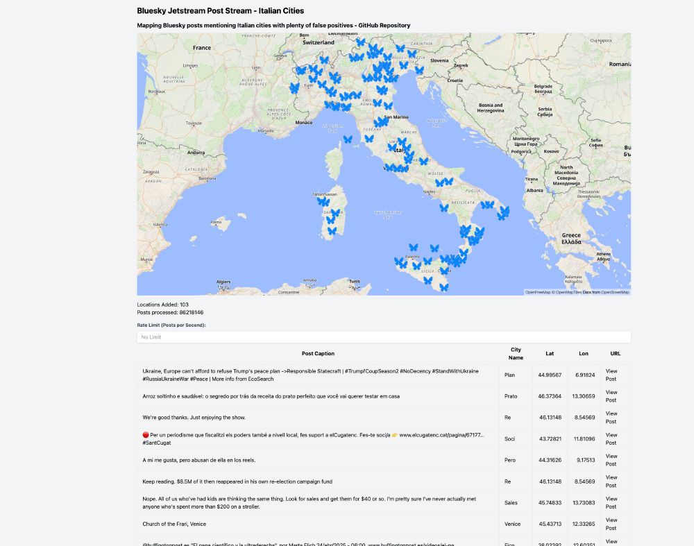
I streamed 86M bluesky posts in my browser from their open jetstreams and naively mapped all mentioned Italian cities.
Even though most of them are false positives, it was still a fun app to build!
do-me.github.io/bluesky-ital...
It's a pity bluesky doesn't offer proper location tagging.
#gischat
Even though most of them are false positives, it was still a fun app to build!
do-me.github.io/bluesky-ital...
It's a pity bluesky doesn't offer proper location tagging.
#gischat
April 26, 2025 at 5:42 PM
I streamed 86M bluesky posts in my browser from their open jetstreams and naively mapped all mentioned Italian cities.
Even though most of them are false positives, it was still a fun app to build!
do-me.github.io/bluesky-ital...
It's a pity bluesky doesn't offer proper location tagging.
#gischat
Even though most of them are false positives, it was still a fun app to build!
do-me.github.io/bluesky-ital...
It's a pity bluesky doesn't offer proper location tagging.
#gischat
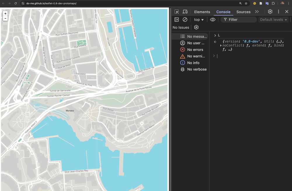
Leaflet 0.8-dev from 10 years ago with a high performance @protomaps.com basemap canvas renderer from 2025? Yes it works 😅
So if you have legacy systems running where you don't have the resources to upgrade you can still replace costly raster tile APIs.
github.com/do-me/leafle...
So if you have legacy systems running where you don't have the resources to upgrade you can still replace costly raster tile APIs.
github.com/do-me/leafle...
April 8, 2025 at 3:48 PM
Leaflet 0.8-dev from 10 years ago with a high performance @protomaps.com basemap canvas renderer from 2025? Yes it works 😅
So if you have legacy systems running where you don't have the resources to upgrade you can still replace costly raster tile APIs.
github.com/do-me/leafle...
So if you have legacy systems running where you don't have the resources to upgrade you can still replace costly raster tile APIs.
github.com/do-me/leafle...
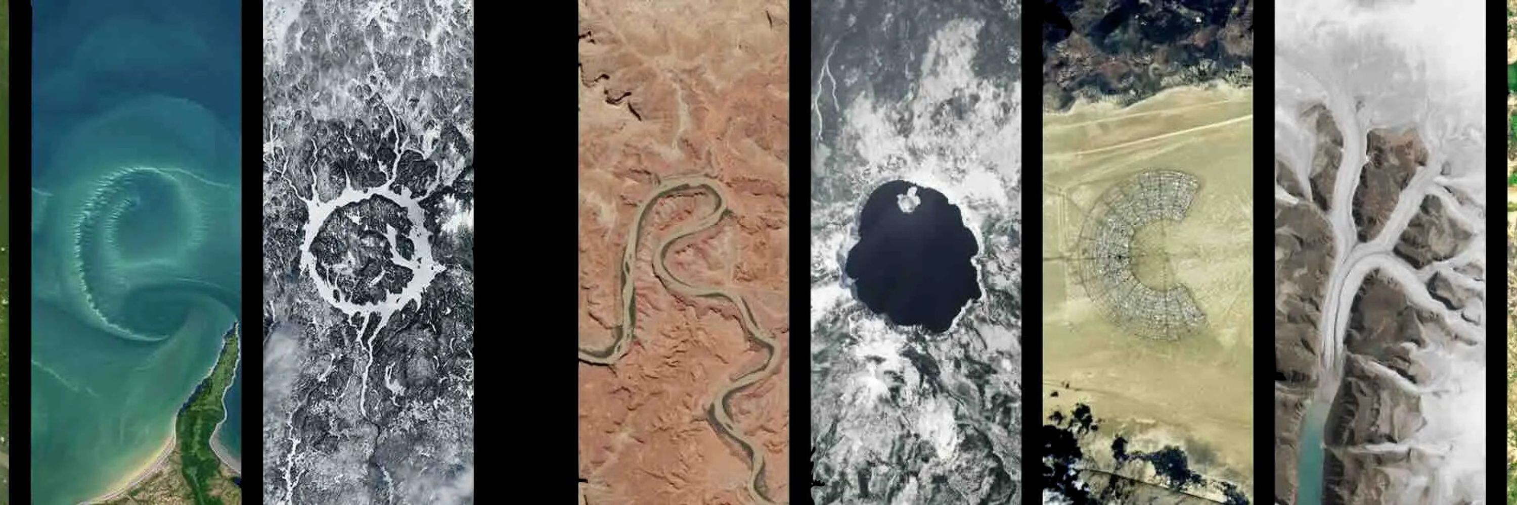
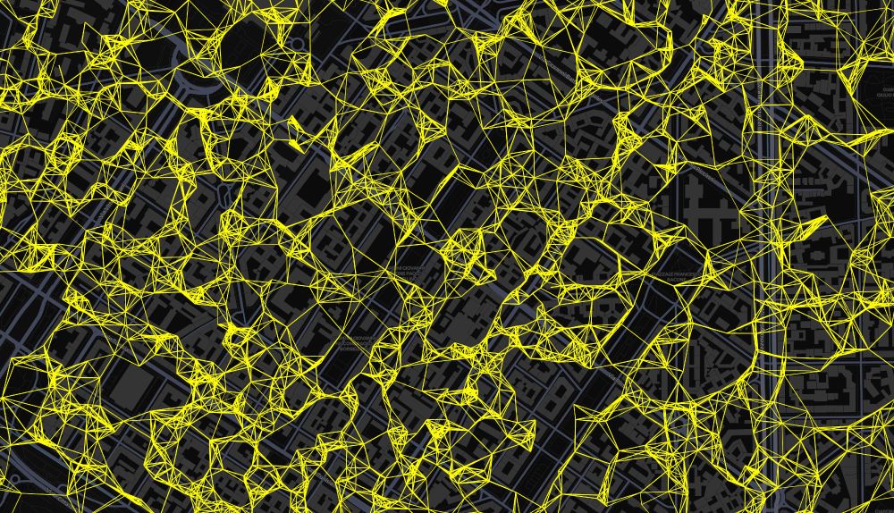
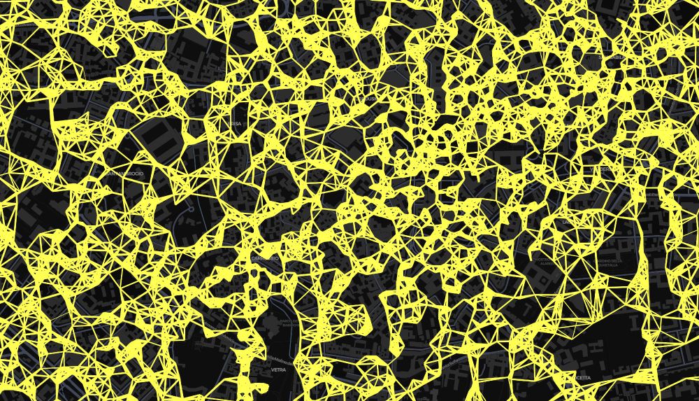
Geospatial graphs have something inherently artsy! Working on large POI DBs at the moment but I'm just too fascinated by these patterns...
#gischat
#gischat
March 4, 2025 at 9:14 PM
Geospatial graphs have something inherently artsy! Working on large POI DBs at the moment but I'm just too fascinated by these patterns...
#gischat
#gischat
New blog post! Spatially filter Foursquare's >100.000.000 rows (10Gb GeoParquet file) in 22 seconds with DuckDB.
geo.rocks/post/duckdb_...
#gischat #duckdb #geopandas
geo.rocks/post/duckdb_...
#gischat #duckdb #geopandas
DuckDB for Geospatial
Learn how to dramatically speed up your geospatial data workflows by using DuckDB instead of GeoPandas. We'll explore loading, filtering, and spatial analysis with the Foursquare dataset and more.
geo.rocks
January 12, 2025 at 1:56 PM
New blog post! Spatially filter Foursquare's >100.000.000 rows (10Gb GeoParquet file) in 22 seconds with DuckDB.
geo.rocks/post/duckdb_...
#gischat #duckdb #geopandas
geo.rocks/post/duckdb_...
#gischat #duckdb #geopandas
After a couple of hours of fixing xcode-related errors I finally managed to bundle my basemap app for iOS.
Using @maplibre.org, @bkgbund.bsky.social bund.bsky.social
free world vector tiles and
@komoot.bsky.social Photon geocoder. Next is Android & a more advanced feature set. youtu.be/sONjXU4eRss
Using @maplibre.org, @bkgbund.bsky.social bund.bsky.social
free world vector tiles and
@komoot.bsky.social Photon geocoder. Next is Android & a more advanced feature set. youtu.be/sONjXU4eRss
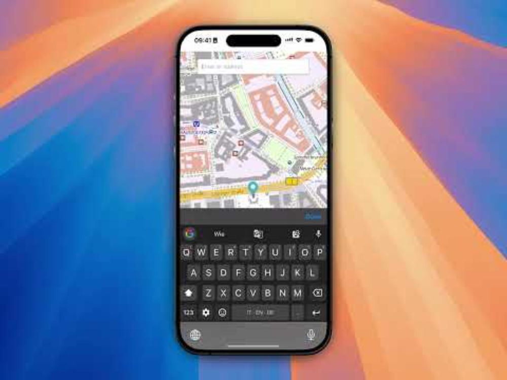
Simple cross-platform maplibre app with basemap.de world vector tiles built with tauri (iOS)
YouTube video by Dominik Weckmüller
youtu.be
January 5, 2025 at 9:33 PM
After a couple of hours of fixing xcode-related errors I finally managed to bundle my basemap app for iOS.
Using @maplibre.org, @bkgbund.bsky.social bund.bsky.social
free world vector tiles and
@komoot.bsky.social Photon geocoder. Next is Android & a more advanced feature set. youtu.be/sONjXU4eRss
Using @maplibre.org, @bkgbund.bsky.social bund.bsky.social
free world vector tiles and
@komoot.bsky.social Photon geocoder. Next is Android & a more advanced feature set. youtu.be/sONjXU4eRss
Bundle geospatial apps with Rust-based tauri. Secure, cross-platform, small sizes and apps open instantly. Check out this minimal app for MacOS I built based on @maplibre.org, @bkgbund.bsky.social's free world vector tiles and @komoot.bsky.social's Photon geocoder.
www.youtube.com/watch?v=b0tN...
www.youtube.com/watch?v=b0tN...
Simple cross-platform maplibre app with basemap.de world vector tiles built with tauri (MacOS)
YouTube video by Dominik Weckmüller
www.youtube.com
December 28, 2024 at 6:06 PM
Bundle geospatial apps with Rust-based tauri. Secure, cross-platform, small sizes and apps open instantly. Check out this minimal app for MacOS I built based on @maplibre.org, @bkgbund.bsky.social's free world vector tiles and @komoot.bsky.social's Photon geocoder.
www.youtube.com/watch?v=b0tN...
www.youtube.com/watch?v=b0tN...
🌍 #30DayMapChallenge Day 29. Data: Overture – Multilingual Geospatial Semantic Search 🔍
Ever wanted to query places around the world in your local language?
E.g.
- "예술적인 장소" in Mongolia
- "Футбол" in Uganda
App: do-me.github.io/overture-pla...
More Info: www.linkedin.com/posts/domini...
#gischat
Ever wanted to query places around the world in your local language?
E.g.
- "예술적인 장소" in Mongolia
- "Футбол" in Uganda
App: do-me.github.io/overture-pla...
More Info: www.linkedin.com/posts/domini...
#gischat
November 29, 2024 at 11:06 AM
🌍 #30DayMapChallenge Day 29. Data: Overture – Multilingual Geospatial Semantic Search 🔍
Ever wanted to query places around the world in your local language?
E.g.
- "예술적인 장소" in Mongolia
- "Футбол" in Uganda
App: do-me.github.io/overture-pla...
More Info: www.linkedin.com/posts/domini...
#gischat
Ever wanted to query places around the world in your local language?
E.g.
- "예술적인 장소" in Mongolia
- "Футбол" in Uganda
App: do-me.github.io/overture-pla...
More Info: www.linkedin.com/posts/domini...
#gischat
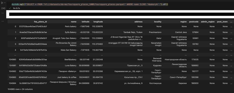
Query Foursquare's 100M OS places in a one-liner with DuckDB without downloading! huggingface.co/datasets/do-...
November 23, 2024 at 4:45 PM
Query Foursquare's 100M OS places in a one-liner with DuckDB without downloading! huggingface.co/datasets/do-...