


DETROITography
@detroitography.com
Detroit's civic technology and open data vanguard. Since 2013, we have worked with non-profits, community development organizations, and government officials to engage Detroiters in open data and civic technology efforts.
http://detroitography.com
http://detroitography.com
Map: Detroit Regional Population Change 2010 to 2020
The Detroit region has faced an on-going loss of population. Recent data and news has highlighted that the City of Detroit is slightly up in population (mostly around Greater Downtown) for the last few years, but the overall rate of population…
The Detroit region has faced an on-going loss of population. Recent data and news has highlighted that the City of Detroit is slightly up in population (mostly around Greater Downtown) for the last few years, but the overall rate of population…

Map: Detroit Regional Population Change 2010 to 2020
The Detroit region has faced an on-going loss of population. Recent data and news has highlighted that the City of Detroit is slightly up in population (mostly around Greater Downtown) for the last few years, but the overall rate of population growth is still below the 2010 population total. A number of inner ring and proximity municipalities also saw population loss since 2010, such as Ferndale, Livonia, Garden City, St.
detroitography.com
January 16, 2026 at 2:59 PM
Map: Detroit Regional Population Change 2010 to 2020
The Detroit region has faced an on-going loss of population. Recent data and news has highlighted that the City of Detroit is slightly up in population (mostly around Greater Downtown) for the last few years, but the overall rate of population…
The Detroit region has faced an on-going loss of population. Recent data and news has highlighted that the City of Detroit is slightly up in population (mostly around Greater Downtown) for the last few years, but the overall rate of population…
Event: Detroit Map Trivia Night with Outlier Media
Join Outlier Media on Feb. 4 for a geography-inspired trivia night celebrating Detroit’s neighborhoods, history and culture. Created in collaboration with Alex B. Hill (DETROITography) and co-hosted by Outlier’s civic life reporter Briana Rice,…
Join Outlier Media on Feb. 4 for a geography-inspired trivia night celebrating Detroit’s neighborhoods, history and culture. Created in collaboration with Alex B. Hill (DETROITography) and co-hosted by Outlier’s civic life reporter Briana Rice,…

Event: Detroit Map Trivia Night with Outlier Media
Join Outlier Media on Feb. 4 for a geography-inspired trivia night celebrating Detroit’s neighborhoods, history and culture. Created in collaboration with Alex B. Hill (DETROITography) and co-hosted by Outlier’s civic life reporter Briana Rice, this night blends maps, storytelling and local knowledge — plus FREE prizes. 💛 Outlier Collective perk: Members get their first drink on us. (Not a member?
detroitography.com
January 9, 2026 at 2:49 PM
Event: Detroit Map Trivia Night with Outlier Media
Join Outlier Media on Feb. 4 for a geography-inspired trivia night celebrating Detroit’s neighborhoods, history and culture. Created in collaboration with Alex B. Hill (DETROITography) and co-hosted by Outlier’s civic life reporter Briana Rice,…
Join Outlier Media on Feb. 4 for a geography-inspired trivia night celebrating Detroit’s neighborhoods, history and culture. Created in collaboration with Alex B. Hill (DETROITography) and co-hosted by Outlier’s civic life reporter Briana Rice,…
Map: Detroit Toxic Chemical Releases 2024
This map displays data from the Toxic Release Inventory (TRI) Program at the EPA, which has been under attack in recent years so I'm hoping the data is still reliable and maintained. The majority of toxic releases in Detroit came from the EQ Detroit…
This map displays data from the Toxic Release Inventory (TRI) Program at the EPA, which has been under attack in recent years so I'm hoping the data is still reliable and maintained. The majority of toxic releases in Detroit came from the EQ Detroit…

Map: Detroit Toxic Chemical Releases 2024
This map displays data from the Toxic Release Inventory (TRI) Program at the EPA, which has been under attack in recent years so I'm hoping the data is still reliable and maintained. The majority of toxic releases in Detroit came from the EQ Detroit (better known as US Ecology) facility near the former incinerator location and from the Stellantis Plant on the city's Eastside. View the interactive map
detroitography.com
January 5, 2026 at 1:50 PM
Map: Detroit Toxic Chemical Releases 2024
This map displays data from the Toxic Release Inventory (TRI) Program at the EPA, which has been under attack in recent years so I'm hoping the data is still reliable and maintained. The majority of toxic releases in Detroit came from the EQ Detroit…
This map displays data from the Toxic Release Inventory (TRI) Program at the EPA, which has been under attack in recent years so I'm hoping the data is still reliable and maintained. The majority of toxic releases in Detroit came from the EQ Detroit…
Open Call: Visualizing Detroit: The Art of Data 2026
This year, we invite artists, technologists, and researchers to submit proposals for the 2026 open call, focusing on the theme of "Networks and Connections." We seek innovative data-driven art that explores the intricate relationships,…
This year, we invite artists, technologists, and researchers to submit proposals for the 2026 open call, focusing on the theme of "Networks and Connections." We seek innovative data-driven art that explores the intricate relationships,…

Open Call: Visualizing Detroit: The Art of Data 2026
This year, we invite artists, technologists, and researchers to submit proposals for the 2026 open call, focusing on the theme of "Networks and Connections." We seek innovative data-driven art that explores the intricate relationships, dependencies, and flows within Detroit's complex systems, whether natural, social, or infrastructural. Submissions should utilize publicly available Detroit Open Data or artist-generated datasets to visualize the city as a dynamic web of interconnected elements.
detroitography.com
January 3, 2026 at 2:04 PM
Open Call: Visualizing Detroit: The Art of Data 2026
This year, we invite artists, technologists, and researchers to submit proposals for the 2026 open call, focusing on the theme of "Networks and Connections." We seek innovative data-driven art that explores the intricate relationships,…
This year, we invite artists, technologists, and researchers to submit proposals for the 2026 open call, focusing on the theme of "Networks and Connections." We seek innovative data-driven art that explores the intricate relationships,…
Pictorial Map of the 18th Annual Convention of the National Association of Real Estate Boards City of Detroit 1925
In 1925, the National Association of Real Estate Boards declared: "Detroit is yours! Realtors!" On this map, the pictorial map people are saying a myriad of gems about the city and I…
In 1925, the National Association of Real Estate Boards declared: "Detroit is yours! Realtors!" On this map, the pictorial map people are saying a myriad of gems about the city and I…

Pictorial Map of the 18th Annual Convention of the National Association of Real Estate Boards City of Detroit 1925
In 1925, the National Association of Real Estate Boards declared: "Detroit is yours! Realtors!" On this map, the pictorial map people are saying a myriad of gems about the city and I wish I could transcribe them all: "This looks as peppy as Los Angeles." "Well well I thought Old Canada was North of the U.S." "Look at that Jim!
detroitography.com
December 10, 2025 at 1:31 PM
Pictorial Map of the 18th Annual Convention of the National Association of Real Estate Boards City of Detroit 1925
In 1925, the National Association of Real Estate Boards declared: "Detroit is yours! Realtors!" On this map, the pictorial map people are saying a myriad of gems about the city and I…
In 1925, the National Association of Real Estate Boards declared: "Detroit is yours! Realtors!" On this map, the pictorial map people are saying a myriad of gems about the city and I…
Map: GLWA Stormwater Control in Metro Detroit
The University of Michigan Urban Collaboratory worked with the Great Lakes Water Authority (GLWA) in 2018 to better handle combined sewer overflows in real-time. More from the project: ... they found that Combined Sewer Overflows have been occurring…
The University of Michigan Urban Collaboratory worked with the Great Lakes Water Authority (GLWA) in 2018 to better handle combined sewer overflows in real-time. More from the project: ... they found that Combined Sewer Overflows have been occurring…

Map: GLWA Stormwater Control in Metro Detroit
The University of Michigan Urban Collaboratory worked with the Great Lakes Water Authority (GLWA) in 2018 to better handle combined sewer overflows in real-time. More from the project: ... they found that Combined Sewer Overflows have been occurring when additional sewer capacity is available. Rather than increasing the amount of storage with costly infrastructure improvements, the research team was able to demonstrate their ability to use a real-time control approach to significantly improve the existing GLWA wastewater and CSO management system by reducing both the occurrence of CSOs and peak flows going to the treatment facility.
detroitography.com
December 8, 2025 at 2:34 PM
Map: GLWA Stormwater Control in Metro Detroit
The University of Michigan Urban Collaboratory worked with the Great Lakes Water Authority (GLWA) in 2018 to better handle combined sewer overflows in real-time. More from the project: ... they found that Combined Sewer Overflows have been occurring…
The University of Michigan Urban Collaboratory worked with the Great Lakes Water Authority (GLWA) in 2018 to better handle combined sewer overflows in real-time. More from the project: ... they found that Combined Sewer Overflows have been occurring…
Event: Detroit Data Forum: Education
Welcome to our Data Forum where we will discuss the education system, how data is tracked, and how data can be used to improve student outcomes. We’ll be joined by the Jeremy Singer, GO DATA Commissioner, Stacey Brockman of WSU's Education Leadership and Policy…
Welcome to our Data Forum where we will discuss the education system, how data is tracked, and how data can be used to improve student outcomes. We’ll be joined by the Jeremy Singer, GO DATA Commissioner, Stacey Brockman of WSU's Education Leadership and Policy…

Event: Detroit Data Forum: Education
Welcome to our Data Forum where we will discuss the education system, how data is tracked, and how data can be used to improve student outcomes. We’ll be joined by the Jeremy Singer, GO DATA Commissioner, Stacey Brockman of WSU's Education Leadership and Policy studies program, and Titus Scott from the Skillman Foundation. Don’t miss out on this opportunity to connect with fellow data enthusiasts and expand your knowledge. WHEN: Friday, December 19th, 12:30-1:30pm WHERE: Virtual WHAT: Join us for our Data Forum where we will discuss education data and uses. RSVP: Zoom
detroitography.com
November 28, 2025 at 2:15 PM
Event: Detroit Data Forum: Education
Welcome to our Data Forum where we will discuss the education system, how data is tracked, and how data can be used to improve student outcomes. We’ll be joined by the Jeremy Singer, GO DATA Commissioner, Stacey Brockman of WSU's Education Leadership and Policy…
Welcome to our Data Forum where we will discuss the education system, how data is tracked, and how data can be used to improve student outcomes. We’ll be joined by the Jeremy Singer, GO DATA Commissioner, Stacey Brockman of WSU's Education Leadership and Policy…
Detroit By The Numbers: November 2025 Data Roundup
Make it count! Detroit By The Numbers latest monthly segment on the Authentically Detroit podcast is live! We highlight significant data and numbers from the past month for Detroiters! Listen to the November Data Roundup 588 Number of pages in the…
Make it count! Detroit By The Numbers latest monthly segment on the Authentically Detroit podcast is live! We highlight significant data and numbers from the past month for Detroiters! Listen to the November Data Roundup 588 Number of pages in the…

Detroit By The Numbers: November 2025 Data Roundup
Make it count! Detroit By The Numbers latest monthly segment on the Authentically Detroit podcast is live! We highlight significant data and numbers from the past month for Detroiters! Listen to the November Data Roundup 588 Number of pages in the recent Detroit Reparations Task Force Report (BridgeDetroit). 36.6% Percent of Detroit households that rely on SNAP/Food Stamps to put food on the table.
detroitography.com
November 26, 2025 at 2:06 PM
Detroit By The Numbers: November 2025 Data Roundup
Make it count! Detroit By The Numbers latest monthly segment on the Authentically Detroit podcast is live! We highlight significant data and numbers from the past month for Detroiters! Listen to the November Data Roundup 588 Number of pages in the…
Make it count! Detroit By The Numbers latest monthly segment on the Authentically Detroit podcast is live! We highlight significant data and numbers from the past month for Detroiters! Listen to the November Data Roundup 588 Number of pages in the…
Map: Belle Isle Commons
Gehl worked with the Belle Isle Conservancy to reimagine what the area around the major cultural institutions on the island. More from Gehl: Belle Isle is Detroit’s premier large open space and home to some of the city’s iconic cultural institutions. Today, however, the…
Gehl worked with the Belle Isle Conservancy to reimagine what the area around the major cultural institutions on the island. More from Gehl: Belle Isle is Detroit’s premier large open space and home to some of the city’s iconic cultural institutions. Today, however, the…

Map: Belle Isle Commons
Gehl worked with the Belle Isle Conservancy to reimagine what the area around the major cultural institutions on the island. More from Gehl: Belle Isle is Detroit’s premier large open space and home to some of the city’s iconic cultural institutions. Today, however, the public space around the core destinations of the Isle invites for car-first, one-off visits — rather than a continuous, lingering experience.
detroitography.com
November 24, 2025 at 7:16 PM
Map: Belle Isle Commons
Gehl worked with the Belle Isle Conservancy to reimagine what the area around the major cultural institutions on the island. More from Gehl: Belle Isle is Detroit’s premier large open space and home to some of the city’s iconic cultural institutions. Today, however, the…
Gehl worked with the Belle Isle Conservancy to reimagine what the area around the major cultural institutions on the island. More from Gehl: Belle Isle is Detroit’s premier large open space and home to some of the city’s iconic cultural institutions. Today, however, the…
Event: Detroit Data Forum: Geospatial Data Sources
Welcome to our Data Forum where we will discuss open data portal and geospatial data sources. We’ll be joined by the Julian Bruinsma from DetroitData.org, Ann VanSlembrouck of SEMCOG, and Zachary Manring from the City of Detroit, Open Data Team.…
Welcome to our Data Forum where we will discuss open data portal and geospatial data sources. We’ll be joined by the Julian Bruinsma from DetroitData.org, Ann VanSlembrouck of SEMCOG, and Zachary Manring from the City of Detroit, Open Data Team.…

Event: Detroit Data Forum: Geospatial Data Sources
Welcome to our Data Forum where we will discuss open data portal and geospatial data sources. We’ll be joined by the Julian Bruinsma from DetroitData.org, Ann VanSlembrouck of SEMCOG, and Zachary Manring from the City of Detroit, Open Data Team. Don’t miss out on this opportunity to connect with fellow data enthusiasts and expand your knowledge. WHEN: Friday, November 21st, 12:30-1:30pm WHERE: Virtual WHAT: Join us for our Data Forum where we will discuss open data portals and geospatial sources. RSVP: Eventbrite
detroitography.com
November 14, 2025 at 4:43 PM
Event: Detroit Data Forum: Geospatial Data Sources
Welcome to our Data Forum where we will discuss open data portal and geospatial data sources. We’ll be joined by the Julian Bruinsma from DetroitData.org, Ann VanSlembrouck of SEMCOG, and Zachary Manring from the City of Detroit, Open Data Team.…
Welcome to our Data Forum where we will discuss open data portal and geospatial data sources. We’ll be joined by the Julian Bruinsma from DetroitData.org, Ann VanSlembrouck of SEMCOG, and Zachary Manring from the City of Detroit, Open Data Team.…
Map: The Original Midtown Community 1953
This historic gem of a map comes from the Reuther Library and Archives, "Community Councils Manual, Dec. 1953" (page 5) published by the Detroit Federation of Community Councils. I've been diving into neighborhood histories and came across mentions of a…
This historic gem of a map comes from the Reuther Library and Archives, "Community Councils Manual, Dec. 1953" (page 5) published by the Detroit Federation of Community Councils. I've been diving into neighborhood histories and came across mentions of a…

Map: The Original Midtown Community 1953
This historic gem of a map comes from the Reuther Library and Archives, "Community Councils Manual, Dec. 1953" (page 5) published by the Detroit Federation of Community Councils. I've been diving into neighborhood histories and came across mentions of a "Midtown Community Council" in the 1950s and had to dig in further. The Detroit Federation of Community Councils was an association of 14 community councils in Detroit.
detroitography.com
November 12, 2025 at 3:32 PM
Map: The Original Midtown Community 1953
This historic gem of a map comes from the Reuther Library and Archives, "Community Councils Manual, Dec. 1953" (page 5) published by the Detroit Federation of Community Councils. I've been diving into neighborhood histories and came across mentions of a…
This historic gem of a map comes from the Reuther Library and Archives, "Community Councils Manual, Dec. 1953" (page 5) published by the Detroit Federation of Community Councils. I've been diving into neighborhood histories and came across mentions of a…
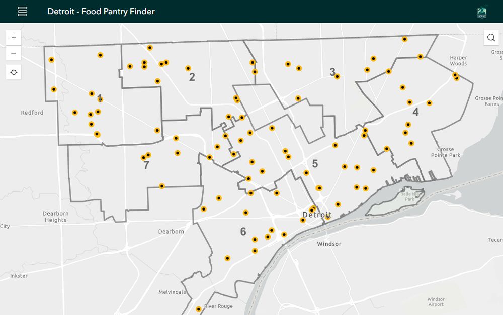
Map: Detroit Food Pantry Finder 2025
The City of Detroit has taken small steps to better engage with the food system in moments of crisis. The first was food box distribution during COVID-19 and now they have a team verifying food pantries in the midst of uncertainty with federal nutrition…
The City of Detroit has taken small steps to better engage with the food system in moments of crisis. The first was food box distribution during COVID-19 and now they have a team verifying food pantries in the midst of uncertainty with federal nutrition…
Map: Detroit Food Pantry Finder 2025
The City of Detroit has taken small steps to better engage with the food system in moments of crisis. The first was food box distribution during COVID-19 and now they have a team verifying food pantries in the midst of uncertainty with federal nutrition benefits. This kind of verification is critical to make sure people can find the right resources and I truly hope this is connected to the wider safety net efforts of the United Way's community information exchange. View the interactive map
detroitography.com
November 10, 2025 at 2:08 PM
Map: Detroit Food Pantry Finder 2025
The City of Detroit has taken small steps to better engage with the food system in moments of crisis. The first was food box distribution during COVID-19 and now they have a team verifying food pantries in the midst of uncertainty with federal nutrition…
The City of Detroit has taken small steps to better engage with the food system in moments of crisis. The first was food box distribution during COVID-19 and now they have a team verifying food pantries in the midst of uncertainty with federal nutrition…
Detroit By The Numbers: October 2025 Data Roundup
Make it count! Detroit By The Numbers latest monthly segment where we highlight significant data and numbers from the past month for Detroiters! 21 New DDOT bus bump-outs along Jefferson Avenue (APTA). 23% Detroit lawmaker attends less than a third…
Make it count! Detroit By The Numbers latest monthly segment where we highlight significant data and numbers from the past month for Detroiters! 21 New DDOT bus bump-outs along Jefferson Avenue (APTA). 23% Detroit lawmaker attends less than a third…

Detroit By The Numbers: October 2025 Data Roundup
Make it count! Detroit By The Numbers latest monthly segment where we highlight significant data and numbers from the past month for Detroiters! 21 New DDOT bus bump-outs along Jefferson Avenue (APTA). 23% Detroit lawmaker attends less than a third of all sessions, but is now running for City Council District 7 (Detroit News) $80M Riverfront park opened, funded by Ralph C.
detroitography.com
November 5, 2025 at 7:35 PM
Detroit By The Numbers: October 2025 Data Roundup
Make it count! Detroit By The Numbers latest monthly segment where we highlight significant data and numbers from the past month for Detroiters! 21 New DDOT bus bump-outs along Jefferson Avenue (APTA). 23% Detroit lawmaker attends less than a third…
Make it count! Detroit By The Numbers latest monthly segment where we highlight significant data and numbers from the past month for Detroiters! 21 New DDOT bus bump-outs along Jefferson Avenue (APTA). 23% Detroit lawmaker attends less than a third…
Event: Lost Subways of North America Book Talk with Jake Berman
We've enjoyed featuring Jake Berman's transit fantasy maps that include Detroit. Come hear him talk about the resulting book "Lost Subways of North America" at Next Chapter Books. WHEN: Thursday, November 13th @ 6:30PM WHERE: Next…
We've enjoyed featuring Jake Berman's transit fantasy maps that include Detroit. Come hear him talk about the resulting book "Lost Subways of North America" at Next Chapter Books. WHEN: Thursday, November 13th @ 6:30PM WHERE: Next…

Event: Lost Subways of North America Book Talk with Jake Berman
We've enjoyed featuring Jake Berman's transit fantasy maps that include Detroit. Come hear him talk about the resulting book "Lost Subways of North America" at Next Chapter Books. WHEN: Thursday, November 13th @ 6:30PM WHERE: Next Chapter Books, 16555 E. Warren, Detroit, MI 48224 WHAT: Join us to hear Jake Berman and Alex Hill in conversation about Detroit transit and other cities that have lost subways. This is a free event, so come and enjoy.
detroitography.com
October 29, 2025 at 1:34 PM
Event: Lost Subways of North America Book Talk with Jake Berman
We've enjoyed featuring Jake Berman's transit fantasy maps that include Detroit. Come hear him talk about the resulting book "Lost Subways of North America" at Next Chapter Books. WHEN: Thursday, November 13th @ 6:30PM WHERE: Next…
We've enjoyed featuring Jake Berman's transit fantasy maps that include Detroit. Come hear him talk about the resulting book "Lost Subways of North America" at Next Chapter Books. WHEN: Thursday, November 13th @ 6:30PM WHERE: Next…
Event: Detroit GIS Day 2025
We are very excited this year to have Sharon Cornelissen as our keynote speaker this year. She is director of housing at the Consumer Federation of America and soon-to-be published book based on her dissertation work: “The Last House on the Block: Black Homeowners,…
We are very excited this year to have Sharon Cornelissen as our keynote speaker this year. She is director of housing at the Consumer Federation of America and soon-to-be published book based on her dissertation work: “The Last House on the Block: Black Homeowners,…

Event: Detroit GIS Day 2025
We are very excited this year to have Sharon Cornelissen as our keynote speaker this year. She is director of housing at the Consumer Federation of America and soon-to-be published book based on her dissertation work: “The Last House on the Block: Black Homeowners, White Homesteaders, and Failed Gentrification in Detroit.” Check out the full list of panels, lightning talks, and workshops!
detroitography.com
October 17, 2025 at 1:58 PM
Event: Detroit GIS Day 2025
We are very excited this year to have Sharon Cornelissen as our keynote speaker this year. She is director of housing at the Consumer Federation of America and soon-to-be published book based on her dissertation work: “The Last House on the Block: Black Homeowners,…
We are very excited this year to have Sharon Cornelissen as our keynote speaker this year. She is director of housing at the Consumer Federation of America and soon-to-be published book based on her dissertation work: “The Last House on the Block: Black Homeowners,…
Event: Detroit Data Forum: Wildlife in the City
Welcome to our Data Forum where we will discuss wildlife in the city. Join us online for lunch-and-learn filled with insightful discussions, tips, and tricks on all things related to the data. We’ll be joined by the Nyeema Harris from the Yale…
Welcome to our Data Forum where we will discuss wildlife in the city. Join us online for lunch-and-learn filled with insightful discussions, tips, and tricks on all things related to the data. We’ll be joined by the Nyeema Harris from the Yale…

Event: Detroit Data Forum: Wildlife in the City
Welcome to our Data Forum where we will discuss wildlife in the city. Join us online for lunch-and-learn filled with insightful discussions, tips, and tricks on all things related to the data. We’ll be joined by the Nyeema Harris from the Yale University, Ava Landgraf of Detroit Bird Alliance, and Joanne Coutts, who has mapped animals along Detroit's historic waterways.
detroitography.com
October 8, 2025 at 2:59 PM
Event: Detroit Data Forum: Wildlife in the City
Welcome to our Data Forum where we will discuss wildlife in the city. Join us online for lunch-and-learn filled with insightful discussions, tips, and tricks on all things related to the data. We’ll be joined by the Nyeema Harris from the Yale…
Welcome to our Data Forum where we will discuss wildlife in the city. Join us online for lunch-and-learn filled with insightful discussions, tips, and tricks on all things related to the data. We’ll be joined by the Nyeema Harris from the Yale…
Detroit By The Numbers: September 2025 Data Roundup
Make it count! Detroit By The Numbers latest monthly segment on the Authentically Detroit podcast is live! We highlight significant data and numbers from the past month for Detroiters! Listen to the September Data Roundup 44 Units of unsubsidized…
Make it count! Detroit By The Numbers latest monthly segment on the Authentically Detroit podcast is live! We highlight significant data and numbers from the past month for Detroiters! Listen to the September Data Roundup 44 Units of unsubsidized…

Detroit By The Numbers: September 2025 Data Roundup
Make it count! Detroit By The Numbers latest monthly segment on the Authentically Detroit podcast is live! We highlight significant data and numbers from the past month for Detroiters! Listen to the September Data Roundup 44 Units of unsubsidized market-rate housing constructed so far in 2025. Many apartment buildings are going into foreclosure. Property insurance has doubled in the last few years.
detroitography.com
October 3, 2025 at 1:48 PM
Detroit By The Numbers: September 2025 Data Roundup
Make it count! Detroit By The Numbers latest monthly segment on the Authentically Detroit podcast is live! We highlight significant data and numbers from the past month for Detroiters! Listen to the September Data Roundup 44 Units of unsubsidized…
Make it count! Detroit By The Numbers latest monthly segment on the Authentically Detroit podcast is live! We highlight significant data and numbers from the past month for Detroiters! Listen to the September Data Roundup 44 Units of unsubsidized…
Event: Imagining Greater Detroit-Windsor: Inspiring Ideas for Thriving Together
Join the Greater Detroit-Windsor Project and Regional Centre for Expertise for a day filled with insightful presentations, panels, discussions, networking opportunities, and interactive collaboration at our inaugural…
Join the Greater Detroit-Windsor Project and Regional Centre for Expertise for a day filled with insightful presentations, panels, discussions, networking opportunities, and interactive collaboration at our inaugural…

Event: Imagining Greater Detroit-Windsor: Inspiring Ideas for Thriving Together
Join the Greater Detroit-Windsor Project and Regional Centre for Expertise for a day filled with insightful presentations, panels, discussions, networking opportunities, and interactive collaboration at our inaugural conference! Agendas and speakers to follow. Don't miss out on this unique opportunity to be a part of a dynamic community dedicated to driving positive change in the region. Reserve your spot today!
detroitography.com
October 1, 2025 at 2:52 PM
Event: Imagining Greater Detroit-Windsor: Inspiring Ideas for Thriving Together
Join the Greater Detroit-Windsor Project and Regional Centre for Expertise for a day filled with insightful presentations, panels, discussions, networking opportunities, and interactive collaboration at our inaugural…
Join the Greater Detroit-Windsor Project and Regional Centre for Expertise for a day filled with insightful presentations, panels, discussions, networking opportunities, and interactive collaboration at our inaugural…
Map: Detroit Walkable Accessibility Score
The City of Detroit has a clear walkability problem outside of certain zones, like Midtown, Corktown, Hamtramck, or pockets in Northwest Detroit. More from the project: ... the Walkable Accessibility Score measures the average accessibility to nearby urban…
The City of Detroit has a clear walkability problem outside of certain zones, like Midtown, Corktown, Hamtramck, or pockets in Northwest Detroit. More from the project: ... the Walkable Accessibility Score measures the average accessibility to nearby urban…

Map: Detroit Walkable Accessibility Score
The City of Detroit has a clear walkability problem outside of certain zones, like Midtown, Corktown, Hamtramck, or pockets in Northwest Detroit. More from the project: ... the Walkable Accessibility Score measures the average accessibility to nearby urban amenities from neighbourhood centers. To create the WAS, we first calculate the distance from every block group centroid (shown on the map above) to the…
detroitography.com
September 29, 2025 at 12:51 PM
Map: Detroit Walkable Accessibility Score
The City of Detroit has a clear walkability problem outside of certain zones, like Midtown, Corktown, Hamtramck, or pockets in Northwest Detroit. More from the project: ... the Walkable Accessibility Score measures the average accessibility to nearby urban…
The City of Detroit has a clear walkability problem outside of certain zones, like Midtown, Corktown, Hamtramck, or pockets in Northwest Detroit. More from the project: ... the Walkable Accessibility Score measures the average accessibility to nearby urban…
Detroit Recreation Property Map 1976
I can't remember where I found this map, but I'm glad that I did. The map is huge and could only be scanned using the large format, flat-bed scanner at the Reuther Library. This map is printed on this heavy paper, thick to the touch almost like a stiff fabric.…
I can't remember where I found this map, but I'm glad that I did. The map is huge and could only be scanned using the large format, flat-bed scanner at the Reuther Library. This map is printed on this heavy paper, thick to the touch almost like a stiff fabric.…

Detroit Recreation Property Map 1976
I can't remember where I found this map, but I'm glad that I did. The map is huge and could only be scanned using the large format, flat-bed scanner at the Reuther Library. This map is printed on this heavy paper, thick to the touch almost like a stiff fabric. The map has some weathering and discoloration, but was clearly a map in active use from at least 1972 to 1976.
detroitography.com
September 24, 2025 at 4:58 PM
Detroit Recreation Property Map 1976
I can't remember where I found this map, but I'm glad that I did. The map is huge and could only be scanned using the large format, flat-bed scanner at the Reuther Library. This map is printed on this heavy paper, thick to the touch almost like a stiff fabric.…
I can't remember where I found this map, but I'm glad that I did. The map is huge and could only be scanned using the large format, flat-bed scanner at the Reuther Library. This map is printed on this heavy paper, thick to the touch almost like a stiff fabric.…
Event: #Maptime Fall 2025 Series
WHEN: Mondays, starting September 15th, from 12-4PM WHERE: Prentis Building Fishbowl, Wayne State University, 5201 Cass Ave. WHAT: Come co-work on your mapping project, get support learning GIS, or just chat about maps! RSVP: Let us know you're coming!
WHEN: Mondays, starting September 15th, from 12-4PM WHERE: Prentis Building Fishbowl, Wayne State University, 5201 Cass Ave. WHAT: Come co-work on your mapping project, get support learning GIS, or just chat about maps! RSVP: Let us know you're coming!

Event: #Maptime Fall 2025 Series
WHEN: Mondays, starting September 15th, from 12-4PM WHERE: Prentis Building Fishbowl, Wayne State University, 5201 Cass Ave. WHAT: Come co-work on your mapping project, get support learning GIS, or just chat about maps! RSVP: Let us know you're coming!
detroitography.com
September 12, 2025 at 12:59 PM
Event: #Maptime Fall 2025 Series
WHEN: Mondays, starting September 15th, from 12-4PM WHERE: Prentis Building Fishbowl, Wayne State University, 5201 Cass Ave. WHAT: Come co-work on your mapping project, get support learning GIS, or just chat about maps! RSVP: Let us know you're coming!
WHEN: Mondays, starting September 15th, from 12-4PM WHERE: Prentis Building Fishbowl, Wayne State University, 5201 Cass Ave. WHAT: Come co-work on your mapping project, get support learning GIS, or just chat about maps! RSVP: Let us know you're coming!
Map: Distressed Communities Index in Detroit 2025
I don't generally look to these index rankings of Detroit, but the comparisons are powerful. Detroit is a donut hole in the region; surrounded by communities of higher prosperity and higher opportunity. The city sits on par with Cleveland, Buffalo,…
I don't generally look to these index rankings of Detroit, but the comparisons are powerful. Detroit is a donut hole in the region; surrounded by communities of higher prosperity and higher opportunity. The city sits on par with Cleveland, Buffalo,…

Map: Distressed Communities Index in Detroit 2025
I don't generally look to these index rankings of Detroit, but the comparisons are powerful. Detroit is a donut hole in the region; surrounded by communities of higher prosperity and higher opportunity. The city sits on par with Cleveland, Buffalo, Newark, and Memphis. What are the known strategies and policies that build opportunity in distressed communities? Investment in youth programming Investment in regional public transportation Zoning reform to increase affordable housing
detroitography.com
September 8, 2025 at 12:59 PM
Map: Distressed Communities Index in Detroit 2025
I don't generally look to these index rankings of Detroit, but the comparisons are powerful. Detroit is a donut hole in the region; surrounded by communities of higher prosperity and higher opportunity. The city sits on par with Cleveland, Buffalo,…
I don't generally look to these index rankings of Detroit, but the comparisons are powerful. Detroit is a donut hole in the region; surrounded by communities of higher prosperity and higher opportunity. The city sits on par with Cleveland, Buffalo,…
Detroit By The Numbers: August 2025 Data Roundup
Make it count! Detroit By The Numbers latest monthly segment on the Authentically Detroit podcast is live! We highlight significant data and numbers from the past month for Detroiters! Listen to the August Data Roundup 90% The overwhelming majority…
Make it count! Detroit By The Numbers latest monthly segment on the Authentically Detroit podcast is live! We highlight significant data and numbers from the past month for Detroiters! Listen to the August Data Roundup 90% The overwhelming majority…

Detroit By The Numbers: August 2025 Data Roundup
Make it count! Detroit By The Numbers latest monthly segment on the Authentically Detroit podcast is live! We highlight significant data and numbers from the past month for Detroiters! Listen to the August Data Roundup 90% The overwhelming majority of polling places have accessibility challenges. Detroit Disability Power (DDP) have conducted a regular poll audit and recently updated their polling place audit, "accessibility problems at more than 90% of Detroit polling locations" - you can now check your polling place and its accessibility at…
detroitography.com
September 3, 2025 at 12:42 PM
Detroit By The Numbers: August 2025 Data Roundup
Make it count! Detroit By The Numbers latest monthly segment on the Authentically Detroit podcast is live! We highlight significant data and numbers from the past month for Detroiters! Listen to the August Data Roundup 90% The overwhelming majority…
Make it count! Detroit By The Numbers latest monthly segment on the Authentically Detroit podcast is live! We highlight significant data and numbers from the past month for Detroiters! Listen to the August Data Roundup 90% The overwhelming majority…
Event: Detroit Data Forum: Traffic Data and Crashes
Welcome to our Data Forum where we will discuss traffic data, mobility, and safety in the city. Join us online for lunch-and-learn filled with insightful discussions, tips, and tricks on all things related to the data. We’ll be joined by the…
Welcome to our Data Forum where we will discuss traffic data, mobility, and safety in the city. Join us online for lunch-and-learn filled with insightful discussions, tips, and tricks on all things related to the data. We’ll be joined by the…

Event: Detroit Data Forum: Traffic Data and Crashes
Welcome to our Data Forum where we will discuss traffic data, mobility, and safety in the city. Join us online for lunch-and-learn filled with insightful discussions, tips, and tricks on all things related to the data. We’ll be joined by the Darius Mason from the City of Detroit's Office of Mobility Innovation, Patrick Bowman of UM Transportation Research Institute, and…
detroitography.com
August 27, 2025 at 1:00 PM
Event: Detroit Data Forum: Traffic Data and Crashes
Welcome to our Data Forum where we will discuss traffic data, mobility, and safety in the city. Join us online for lunch-and-learn filled with insightful discussions, tips, and tricks on all things related to the data. We’ll be joined by the…
Welcome to our Data Forum where we will discuss traffic data, mobility, and safety in the city. Join us online for lunch-and-learn filled with insightful discussions, tips, and tricks on all things related to the data. We’ll be joined by the…
Map: Detroit SMART MODES Road Safety Hub
The City of Detroit has launched a new tool to track road safety: The Detroit SMART MODES dashboard is officially live! This powerful new tool uses real-time data to detect near-misses and support smarter, safer street design across the city. Developed in…
The City of Detroit has launched a new tool to track road safety: The Detroit SMART MODES dashboard is officially live! This powerful new tool uses real-time data to detect near-misses and support smarter, safer street design across the city. Developed in…

Map: Detroit SMART MODES Road Safety Hub
The City of Detroit has launched a new tool to track road safety: The Detroit SMART MODES dashboard is officially live! This powerful new tool uses real-time data to detect near-misses and support smarter, safer street design across the city. Developed in collaboration with leading tech partners and community stakeholders, the dashboard marks a major step forward in making Detroit’s mobility system more connected and people-centered.
detroitography.com
August 25, 2025 at 1:08 PM
Map: Detroit SMART MODES Road Safety Hub
The City of Detroit has launched a new tool to track road safety: The Detroit SMART MODES dashboard is officially live! This powerful new tool uses real-time data to detect near-misses and support smarter, safer street design across the city. Developed in…
The City of Detroit has launched a new tool to track road safety: The Detroit SMART MODES dashboard is officially live! This powerful new tool uses real-time data to detect near-misses and support smarter, safer street design across the city. Developed in…