


Custom Course Maps
@coursemaps.bsky.social
cartographer, disc golfer, PDGA #15699
https://customcoursemaps.com/
https://customcoursemaps.com/
DGPT Idlewild profiles have some odd errors. But the two that have me scratching my head are 18 and 5 FPO where the elevation tee to basket is reversed.
@discgolfnetwork.bsky.social @perksofdiscgolf.bsky.social
@discgolfnetwork.bsky.social @perksofdiscgolf.bsky.social

August 23, 2025 at 6:02 PM
DGPT Idlewild profiles have some odd errors. But the two that have me scratching my head are 18 and 5 FPO where the elevation tee to basket is reversed.
@discgolfnetwork.bsky.social @perksofdiscgolf.bsky.social
@discgolfnetwork.bsky.social @perksofdiscgolf.bsky.social
Glad to see elevation profiles in the DGPT caddie books but they are over simplified to the point of making what is hard to depict on video even more confusing...
1) The slope does not flatten out at the basket and gets steeper right behind.
4) The terrain climbs up after crossing the second pond.
1) The slope does not flatten out at the basket and gets steeper right behind.
4) The terrain climbs up after crossing the second pond.

August 23, 2025 at 1:27 PM
Glad to see elevation profiles in the DGPT caddie books but they are over simplified to the point of making what is hard to depict on video even more confusing...
1) The slope does not flatten out at the basket and gets steeper right behind.
4) The terrain climbs up after crossing the second pond.
1) The slope does not flatten out at the basket and gets steeper right behind.
4) The terrain climbs up after crossing the second pond.

I make lots of maps remotely and use multiple sources to collect data. The pro tour rarely includes elevation info. This is what I measured for Bad Rock Creek.
#discgolf
#discgolf

April 16, 2025 at 12:37 PM
I make lots of maps remotely and use multiple sources to collect data. The pro tour rarely includes elevation info. This is what I measured for Bad Rock Creek.
#discgolf
#discgolf

Eagles Crossing is a course with all the amenities. The tee signs however don't include any elevation information which can easily be displayed along with other information when using geo-referenced imagery.
#discgolf
#discgolf

April 12, 2025 at 4:16 PM
Eagles Crossing is a course with all the amenities. The tee signs however don't include any elevation information which can easily be displayed along with other information when using geo-referenced imagery.
#discgolf
#discgolf
Hole 18, Sprinkle Valley from the MVP Open at Austin.
1) A full map drawn to scale with elevation profile and distances.
2) Elevation profile of the approach to the green.
3) Terrain map around 18's green showing the old tanks (ponds) that can flood in heavy rain.
1) A full map drawn to scale with elevation profile and distances.
2) Elevation profile of the approach to the green.
3) Terrain map around 18's green showing the old tanks (ponds) that can flood in heavy rain.


March 26, 2025 at 6:34 PM
Hole 18, Sprinkle Valley from the MVP Open at Austin.
1) A full map drawn to scale with elevation profile and distances.
2) Elevation profile of the approach to the green.
3) Terrain map around 18's green showing the old tanks (ponds) that can flood in heavy rain.
1) A full map drawn to scale with elevation profile and distances.
2) Elevation profile of the approach to the green.
3) Terrain map around 18's green showing the old tanks (ponds) that can flood in heavy rain.
I didn't catch this video podcast when it aired last summer but I'm glad I ran across it...ringing endorsement indeed 😎
#discgolf #cartography #maps
#discgolf #cartography #maps
January 20, 2025 at 9:10 PM
I didn't catch this video podcast when it aired last summer but I'm glad I ran across it...ringing endorsement indeed 😎
#discgolf #cartography #maps
#discgolf #cartography #maps
Always rewarding to chat with a team of disc golfers (hosts and producer) that really 'get' what you are trying to accomplish.😎

We sat down and chatted with @coursemaps.bsky.social for our latest episode! 🤙
IMO this is one of our better episodes. You should definitely check it out and tell a disc golf friend. Thanks everyone!
youtu.be/jb3uLuqJchM
IMO this is one of our better episodes. You should definitely check it out and tell a disc golf friend. Thanks everyone!
youtu.be/jb3uLuqJchM

Disc Golf NEEDS to Fix THIS... // Custom Course Maps [43]
YouTube video by Hanging Loose Disc Golf
youtu.be
January 7, 2025 at 4:29 AM
Always rewarding to chat with a team of disc golfers (hosts and producer) that really 'get' what you are trying to accomplish.😎
Elevation tells a story and complicates an already tough fairway. The second shot has to navigate the OB and woods and your rangefinder won't help with the target around the corner and over the hill.
@randisc.com
@bagelpowered.bsky.social
@greensplatter.bsky.social
@hangingloosepod.bsky.social
@randisc.com
@bagelpowered.bsky.social
@greensplatter.bsky.social
@hangingloosepod.bsky.social

December 11, 2024 at 1:01 AM
Elevation tells a story and complicates an already tough fairway. The second shot has to navigate the OB and woods and your rangefinder won't help with the target around the corner and over the hill.
@randisc.com
@bagelpowered.bsky.social
@greensplatter.bsky.social
@hangingloosepod.bsky.social
@randisc.com
@bagelpowered.bsky.social
@greensplatter.bsky.social
@hangingloosepod.bsky.social
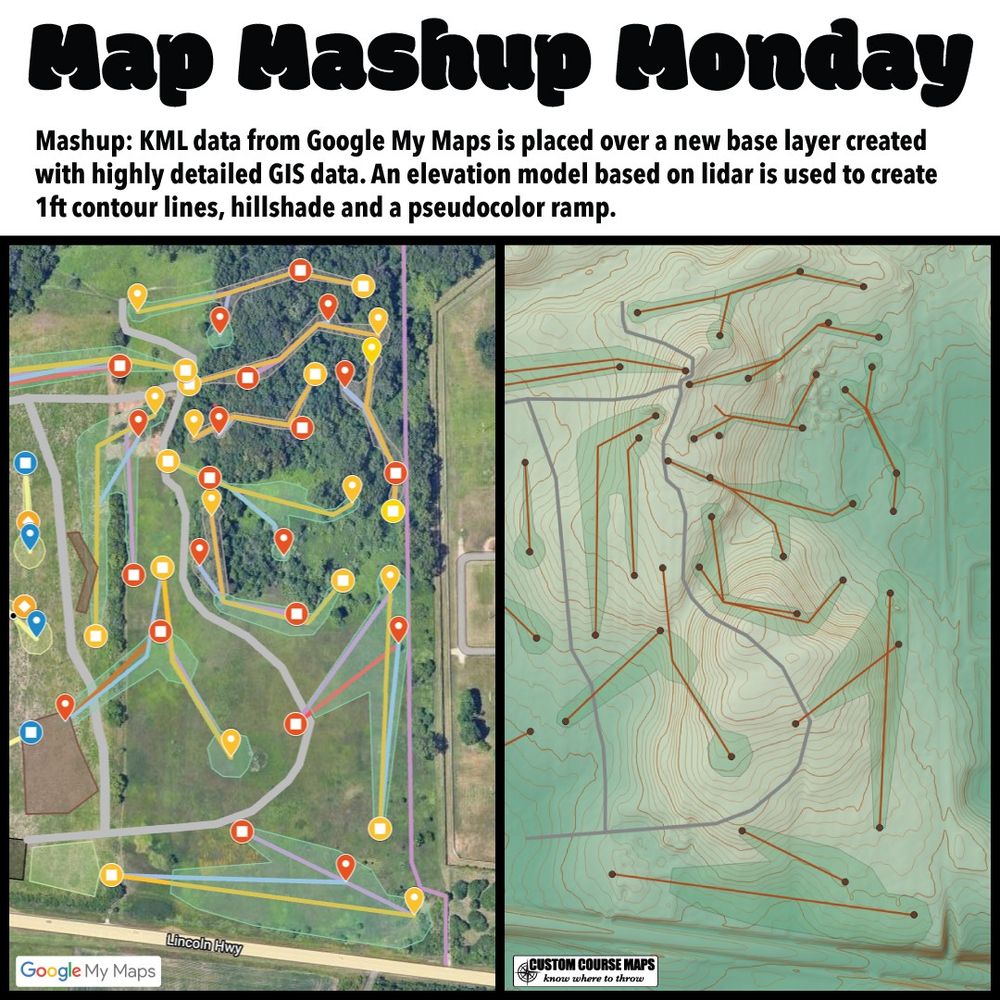
I was sent this disc golf course mockup by a designer wanting a cost estimate for signage. My first step is to look at the elevation of the property. KML data imports easily into GIS software making a mashup like this rather simple.
customcoursemaps.com
customcoursemaps.com
December 9, 2024 at 11:08 PM
I was sent this disc golf course mockup by a designer wanting a cost estimate for signage. My first step is to look at the elevation of the property. KML data imports easily into GIS software making a mashup like this rather simple.
customcoursemaps.com
customcoursemaps.com
Elevation base layers make a huge difference for disc golf maps. Here is a breakdown of how that layer is created.
see more: customcoursemaps.com
see more: customcoursemaps.com

December 9, 2024 at 2:31 PM
Elevation base layers make a huge difference for disc golf maps. Here is a breakdown of how that layer is created.
see more: customcoursemaps.com
see more: customcoursemaps.com
Disc Golf Pro Tour maps and tee signs use a flat base layer. Not sure if this omission is intentional since the announcers always mention how the camera doesn't really show the steepness of the fairway. Maybe they don't know how to include it since it requires some processing. Check out this mashup.

December 3, 2024 at 1:20 AM
Disc Golf Pro Tour maps and tee signs use a flat base layer. Not sure if this omission is intentional since the announcers always mention how the camera doesn't really show the steepness of the fairway. Maybe they don't know how to include it since it requires some processing. Check out this mashup.
Elevation data is great way to create base layers with precise scale and detail. The shorelines and small hills are accurately represented. This data also allows elevation profiles to be easily rendered.
customcoursemaps.com/tee-signs/
customcoursemaps.com/tee-signs/

November 26, 2024 at 5:25 PM
Elevation data is great way to create base layers with precise scale and detail. The shorelines and small hills are accurately represented. This data also allows elevation profiles to be easily rendered.
customcoursemaps.com/tee-signs/
customcoursemaps.com/tee-signs/
Tee signs with a tactical feel. Details matter!
• Full size map. (not placed in a small box)
• Elevation change tee to pin.
• 1ft contour lines.
• Down Range distance.
• Elevation Profile.
see more: customcoursemaps.com
• Full size map. (not placed in a small box)
• Elevation change tee to pin.
• 1ft contour lines.
• Down Range distance.
• Elevation Profile.
see more: customcoursemaps.com

November 23, 2024 at 9:04 PM
Tee signs with a tactical feel. Details matter!
• Full size map. (not placed in a small box)
• Elevation change tee to pin.
• 1ft contour lines.
• Down Range distance.
• Elevation Profile.
see more: customcoursemaps.com
• Full size map. (not placed in a small box)
• Elevation change tee to pin.
• 1ft contour lines.
• Down Range distance.
• Elevation Profile.
see more: customcoursemaps.com
This disc golf tee sign is from a recent project in a Twin Cities suburb in Minnesota. Details matter!
See more: customcoursemaps.com/minnesota/mn...
@hangingloosepod.bsky.social @frolfermagazine.bsky.social @glowlabsdg.bsky.social
See more: customcoursemaps.com/minnesota/mn...
@hangingloosepod.bsky.social @frolfermagazine.bsky.social @glowlabsdg.bsky.social

November 20, 2024 at 12:37 AM
This disc golf tee sign is from a recent project in a Twin Cities suburb in Minnesota. Details matter!
See more: customcoursemaps.com/minnesota/mn...
@hangingloosepod.bsky.social @frolfermagazine.bsky.social @glowlabsdg.bsky.social
See more: customcoursemaps.com/minnesota/mn...
@hangingloosepod.bsky.social @frolfermagazine.bsky.social @glowlabsdg.bsky.social
This mashup adds elevation to the base map of part of Harmony Bends. Pre existing lidar and GIS data play a big role in remotely creating disc golf maps. While I have never visited this course, I can still pull together enough data to to create an accurate map that highlights terrain.

November 19, 2024 at 5:16 AM
This mashup adds elevation to the base map of part of Harmony Bends. Pre existing lidar and GIS data play a big role in remotely creating disc golf maps. While I have never visited this course, I can still pull together enough data to to create an accurate map that highlights terrain.
BlueSky is a breath of fresh air and I need to fill that media folder!
Elevation data helps describe a disc golf fairway. It also keeps you honest when delineating shorelines. This comparison illustrates that point. Original tee map on the left and mine on the right with a profile along bottom.
Elevation data helps describe a disc golf fairway. It also keeps you honest when delineating shorelines. This comparison illustrates that point. Original tee map on the left and mine on the right with a profile along bottom.

November 16, 2024 at 3:06 AM
BlueSky is a breath of fresh air and I need to fill that media folder!
Elevation data helps describe a disc golf fairway. It also keeps you honest when delineating shorelines. This comparison illustrates that point. Original tee map on the left and mine on the right with a profile along bottom.
Elevation data helps describe a disc golf fairway. It also keeps you honest when delineating shorelines. This comparison illustrates that point. Original tee map on the left and mine on the right with a profile along bottom.