

CoastView: Go Exploring
@coastview.org
Explore the coast of Alaska and the Pacific Northwest. Every place tells a story layered across time. Understanding these stories helps us understand ourselves and our world. Read more: https://coastview.org
Pachena Point Lighthouse sits on the west coast of Vancouver Island in Pacific Rim National Park Reserve, about 82 miles (132 km) northwest of Victoria and 8 miles (13 km) south-southeast of Bamfield, British Columbia. Read more here: coastview.org/2026/02/19/p...
February 20, 2026 at 2:35 PM
Pachena Point Lighthouse sits on the west coast of Vancouver Island in Pacific Rim National Park Reserve, about 82 miles (132 km) northwest of Victoria and 8 miles (13 km) south-southeast of Bamfield, British Columbia. Read more here: coastview.org/2026/02/19/p...
Mutton Cove is an embayment on Unalaska Island, about 0.3 miles (0.5 km) across, on the northern shore of Chernofski Harbor, about 64 miles (103 km) north-east of Nikolski and 53 miles (85 km) south-west of Dutch Harbor, Alaska. Read more here: coastview.org/2026/02/18/m...
February 19, 2026 at 2:43 PM
Mutton Cove is an embayment on Unalaska Island, about 0.3 miles (0.5 km) across, on the northern shore of Chernofski Harbor, about 64 miles (103 km) north-east of Nikolski and 53 miles (85 km) south-west of Dutch Harbor, Alaska. Read more here: coastview.org/2026/02/18/m...
Polly Creek flows generally south for nine miles (14 km) to the western shore of Cook Inlet, about 56 miles (90 km) north-west of Homer and 46 miles (74 km) south-west of Kenai, Alaska. Read more here: coastview.org/2026/02/17/p...
February 18, 2026 at 2:52 PM
Polly Creek flows generally south for nine miles (14 km) to the western shore of Cook Inlet, about 56 miles (90 km) north-west of Homer and 46 miles (74 km) south-west of Kenai, Alaska. Read more here: coastview.org/2026/02/17/p...
King Philip was a clipper ship that wrecked in 1878 on Ocean Beach, on the west coast of the San Francisco Peninsula, about 1 mile (1.6 km) south of Golden Gate Park and 7 miles (11 km) west-south-west of downtown San Francisco, California. Read more here: coastview.org/2026/02/16/k...
February 17, 2026 at 2:59 PM
King Philip was a clipper ship that wrecked in 1878 on Ocean Beach, on the west coast of the San Francisco Peninsula, about 1 mile (1.6 km) south of Golden Gate Park and 7 miles (11 km) west-south-west of downtown San Francisco, California. Read more here: coastview.org/2026/02/16/k...
Mink Bay is an estuary extending south for 5.4 miles (8.7 km) from Boca de Quadra, an embayment on the east side of Revillagigedo Channel, about 54 miles (87 km) north-northwest of Prince Rupert and 40 miles (65 km) south-east of Ketchikan, Alaska. Read more here: coastview.org/2026/02/15/m...
February 16, 2026 at 2:28 PM
Mink Bay is an estuary extending south for 5.4 miles (8.7 km) from Boca de Quadra, an embayment on the east side of Revillagigedo Channel, about 54 miles (87 km) north-northwest of Prince Rupert and 40 miles (65 km) south-east of Ketchikan, Alaska. Read more here: coastview.org/2026/02/15/m...
Lime Kiln Lighthouse was established in 1919 on Lime Kiln Point on San Juan Island's west coast, about 12 miles (19 km) northeast of Victoria, British Columbia and 6.4 miles (10 km) west-southwest of Friday Harbor, Washington. Read more here: coastview.org/2026/02/14/l...
February 15, 2026 at 2:35 PM
Lime Kiln Lighthouse was established in 1919 on Lime Kiln Point on San Juan Island's west coast, about 12 miles (19 km) northeast of Victoria, British Columbia and 6.4 miles (10 km) west-southwest of Friday Harbor, Washington. Read more here: coastview.org/2026/02/14/l...
Twin Hills is a Yup'ik village on the left bank of the Togiak River at the head of Togiak Bay, about 130 miles (209 km) south-east of Bethel and 64 miles (103 km) west of Dillingham, Alaska. Read more here: coastview.org/2026/02/13/t...
February 14, 2026 at 2:23 PM
Twin Hills is a Yup'ik village on the left bank of the Togiak River at the head of Togiak Bay, about 130 miles (209 km) south-east of Bethel and 64 miles (103 km) west of Dillingham, Alaska. Read more here: coastview.org/2026/02/13/t...
Tutka Bay Lagoon hosts a fish hatchery on the southern shore of Tutka Bay in Kachemak Bay State Park, roughly 10 miles (16 km) east of Seldovia and 15 miles (24 km) south-southeast of Homer, Alaska. Read more here: coastview.org/2026/02/12/t...
February 13, 2026 at 2:30 PM
Tutka Bay Lagoon hosts a fish hatchery on the southern shore of Tutka Bay in Kachemak Bay State Park, roughly 10 miles (16 km) east of Seldovia and 15 miles (24 km) south-southeast of Homer, Alaska. Read more here: coastview.org/2026/02/12/t...
Staines Point is the southern tip of the Trial Islands, roughly 3.5 miles (5.6 km) south-east of Victoria and 2 miles (3.2 km) south-south-east of Oak Bay, British Columbia. Read more here: coastview.org/2026/02/11/s...
February 12, 2026 at 3:40 PM
Staines Point is the southern tip of the Trial Islands, roughly 3.5 miles (5.6 km) south-east of Victoria and 2 miles (3.2 km) south-south-east of Oak Bay, British Columbia. Read more here: coastview.org/2026/02/11/s...
La Jenelle was a passenger ship that went aground and wrecked in 1970 on Silver Strand at Port Hueneme, about 33 miles (53 km) south-east of Santa Barbara and 3.3 miles (5.3 km) south of Oxnard, California. Read more here: coastview.org/2026/02/10/l...
February 11, 2026 at 2:10 PM
La Jenelle was a passenger ship that went aground and wrecked in 1970 on Silver Strand at Port Hueneme, about 33 miles (53 km) south-east of Santa Barbara and 3.3 miles (5.3 km) south of Oxnard, California. Read more here: coastview.org/2026/02/10/l...
The steamship Yukon ran aground on the north-west end of Sanak Island on what is now called Yukon Reef, about 156 miles (251 km) east-north-east of Dutch Harbor and 48 miles (77 km) south-south-west of King Cove, Alaska. Read more here: coastview.org/2026/02/09/s...
February 10, 2026 at 3:08 PM
The steamship Yukon ran aground on the north-west end of Sanak Island on what is now called Yukon Reef, about 156 miles (251 km) east-north-east of Dutch Harbor and 48 miles (77 km) south-south-west of King Cove, Alaska. Read more here: coastview.org/2026/02/09/s...
Point Elrington is a tied-island connected by a gravel isthmus to the south-western tip of Elrington Island in the Gulf of Alaska, about 96 miles (155 km) south-west of Cordova and 43 miles (69 km) east-south-east of Seward, Alaska. Read more here: coastview.org/2026/02/08/p...
February 9, 2026 at 2:53 PM
Point Elrington is a tied-island connected by a gravel isthmus to the south-western tip of Elrington Island in the Gulf of Alaska, about 96 miles (155 km) south-west of Cordova and 43 miles (69 km) east-south-east of Seward, Alaska. Read more here: coastview.org/2026/02/08/p...
Clatsop Spit projects north from the south bank of the Columbia River and the submerged portion forms the Columbia River Bar, about 80 miles (129 km) northwest of Portland and 9 miles (15 km) west-northwest of Astoria, Oregon. Read more here: coastview.org/2026/02/07/c...
February 8, 2026 at 2:27 PM
Clatsop Spit projects north from the south bank of the Columbia River and the submerged portion forms the Columbia River Bar, about 80 miles (129 km) northwest of Portland and 9 miles (15 km) west-northwest of Astoria, Oregon. Read more here: coastview.org/2026/02/07/c...
Kachemak Selo is a small community at the head of Kachemak Bay adjacent to the Fox River Flats on the Kenai Peninsula, about 27 miles (44 km) southeast of Ninilchik and 20 miles (32 km) northeast of Homer, Alaska. Read more here: coastview.org/2026/02/06/k...
February 7, 2026 at 3:18 PM
Kachemak Selo is a small community at the head of Kachemak Bay adjacent to the Fox River Flats on the Kenai Peninsula, about 27 miles (44 km) southeast of Ninilchik and 20 miles (32 km) northeast of Homer, Alaska. Read more here: coastview.org/2026/02/06/k...
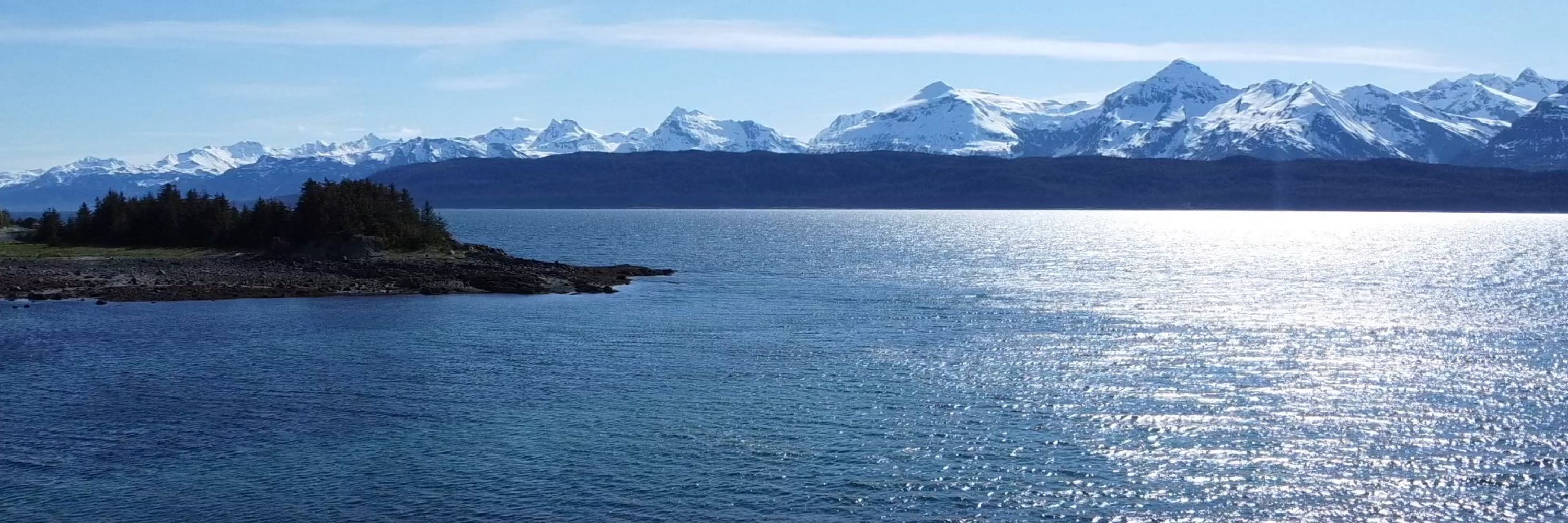
Excursion Inlet is an embayment extending 11 miles (18 km) north-northwest from the northern coast of Icy Strait to the mouth of Excursion River, about 38 miles (61 km) west-northwest of Juneau and 9.5 miles (15 km) east of Gustavus, Alaska. Read more here: coastview.org/2026/02/05/e...
February 6, 2026 at 2:27 PM
Excursion Inlet is an embayment extending 11 miles (18 km) north-northwest from the northern coast of Icy Strait to the mouth of Excursion River, about 38 miles (61 km) west-northwest of Juneau and 9.5 miles (15 km) east of Gustavus, Alaska. Read more here: coastview.org/2026/02/05/e...
Butedale is a historical salmon cannery and community located on a small embayment adjacent to Butedale Falls on Princess Royal Island, about 103 miles (166 km) south-east of Prince Rupert and 59 miles (95 km) south of Kitimat, British Columbia. Read more here: coastview.org/2026/02/04/b...
February 5, 2026 at 2:35 PM
Butedale is a historical salmon cannery and community located on a small embayment adjacent to Butedale Falls on Princess Royal Island, about 103 miles (166 km) south-east of Prince Rupert and 59 miles (95 km) south of Kitimat, British Columbia. Read more here: coastview.org/2026/02/04/b...
Treadwell is a historical gold mine on the eastern coast of Douglas Island on Gastineau Channel, about 1.2 miles (1.9 km) south-east of the community of Douglas and 3 miles (4.8 km) south-east of Juneau, Alaska. Read more here: coastview.org/2026/02/03/t...
February 4, 2026 at 2:33 PM
Treadwell is a historical gold mine on the eastern coast of Douglas Island on Gastineau Channel, about 1.2 miles (1.9 km) south-east of the community of Douglas and 3 miles (4.8 km) south-east of Juneau, Alaska. Read more here: coastview.org/2026/02/03/t...
SS Palo Alto is a shipwreck now serving as an artificial reef located at Seacliff State Beach on the northern coast of Monterey Bay, approximately 6.4 miles (10.3 km) east of Santa Cruz and 0.9 miles (1.5 km) southwest of Aptos, California. Read more here: coastview.org/2026/02/02/s...
February 3, 2026 at 2:57 PM
SS Palo Alto is a shipwreck now serving as an artificial reef located at Seacliff State Beach on the northern coast of Monterey Bay, approximately 6.4 miles (10.3 km) east of Santa Cruz and 0.9 miles (1.5 km) southwest of Aptos, California. Read more here: coastview.org/2026/02/02/s...
Amakdedori Creek drains a watershed on the eastern flank of the Aleutian Range and flows south-east for 10 miles (16 km) to Kamishak Bay, about 26 miles (42 km) south-west of Augustine Island and 95 miles (153 km) south-west of Homer, Alaska. Read more here: coastview.org/2026/02/01/a...
February 2, 2026 at 2:29 PM
Amakdedori Creek drains a watershed on the eastern flank of the Aleutian Range and flows south-east for 10 miles (16 km) to Kamishak Bay, about 26 miles (42 km) south-west of Augustine Island and 95 miles (153 km) south-west of Homer, Alaska. Read more here: coastview.org/2026/02/01/a...
New Carissa was a 639-foot (195 m) freighter that grounded on North Spit in 1999, causing an oil spill about 5 miles (8 km) north-west of Coos Bay and 4 miles (6.5 km) west of the community of North Bend, Oregon. Read more here: coastview.org/2026/01/31/n...
February 1, 2026 at 2:39 PM
New Carissa was a 639-foot (195 m) freighter that grounded on North Spit in 1999, causing an oil spill about 5 miles (8 km) north-west of Coos Bay and 4 miles (6.5 km) west of the community of North Bend, Oregon. Read more here: coastview.org/2026/01/31/n...
The Nick Dudiak Fishing Lagoon, also known as the Fishing Hole, is located on the Homer Spit, about 14 miles (23 km) north-east of Seldovia and 4 miles (6.4 km) south-east of Homer, Alaska. Read more here: coastview.org/2026/01/30/d...
January 31, 2026 at 2:49 PM
The Nick Dudiak Fishing Lagoon, also known as the Fishing Hole, is located on the Homer Spit, about 14 miles (23 km) north-east of Seldovia and 4 miles (6.4 km) south-east of Homer, Alaska. Read more here: coastview.org/2026/01/30/d...
Siwash Rock is a sea stack on the western shoreline of Stanley Park on Burrard Inlet, between English Bay to the south and the entrance to Vancouver Harbour to the north, about 3 miles (5 km) north-west of downtown Vancouver, British Columbia. Read more here: coastview.org/2026/01/29/s...
January 30, 2026 at 2:36 PM
Siwash Rock is a sea stack on the western shoreline of Stanley Park on Burrard Inlet, between English Bay to the south and the entrance to Vancouver Harbour to the north, about 3 miles (5 km) north-west of downtown Vancouver, British Columbia. Read more here: coastview.org/2026/01/29/s...
Valdez Marine Terminal is located on the southern shore of Port Valdez, about 124 miles (200 km) east of Anchorage and 3.5 miles (5.6 km) south of the community of Valdez, Alaska. Read more here: coastview.org/2026/01/28/v...
January 29, 2026 at 2:21 PM
Valdez Marine Terminal is located on the southern shore of Port Valdez, about 124 miles (200 km) east of Anchorage and 3.5 miles (5.6 km) south of the community of Valdez, Alaska. Read more here: coastview.org/2026/01/28/v...
Tyee is the site of a historical cannery and shore whaling station in Murder Cove, an embayment about 0.7 miles (1.1 km) across on Admiralty Island, about 24 miles (39 km) west of Kake and 11 miles (18 km) south-east of Baranof, Alaska. Read more here: coastview.org/2026/01/27/m...
January 28, 2026 at 2:59 PM
Tyee is the site of a historical cannery and shore whaling station in Murder Cove, an embayment about 0.7 miles (1.1 km) across on Admiralty Island, about 24 miles (39 km) west of Kake and 11 miles (18 km) south-east of Baranof, Alaska. Read more here: coastview.org/2026/01/27/m...
SS Dominator is a shipwrecked freighter that ran aground in 1961 on the Palos Verdes Peninsula, about 13 miles (21 km) west of Long Beach and 5.6 miles (9 km) south-southwest of Redondo Beach, California. Read more here: coastview.org/2026/01/26/s...
January 27, 2026 at 2:33 PM
SS Dominator is a shipwrecked freighter that ran aground in 1961 on the Palos Verdes Peninsula, about 13 miles (21 km) west of Long Beach and 5.6 miles (9 km) south-southwest of Redondo Beach, California. Read more here: coastview.org/2026/01/26/s...
