


Chris Phillips
@chriswxpulse.bsky.social
Alert: Special Weather Statement: Moderate. Affects Wayne, Fayette, Union. Expires at N/A. https://tinyurl.com/2yp4cf55

December 19, 2025 at 10:25 AM
Alert: Special Weather Statement: Moderate. Affects Wayne, Fayette, Union. Expires at N/A. https://tinyurl.com/2yp4cf55
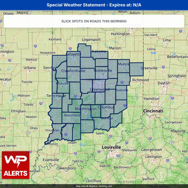
Alert: Special Weather Statement: Moderate. Affects Carroll, Warren, Tippecanoe. Expires at N/A. https://tinyurl.com/283hn745
December 19, 2025 at 9:05 AM
Alert: Special Weather Statement: Moderate. Affects Carroll, Warren, Tippecanoe. Expires at N/A. https://tinyurl.com/283hn745
Alert: Special Weather Statement: Moderate. Affects Orange, Washington, Scott. Expires at N/A. https://tinyurl.com/2yvszyg4

December 19, 2025 at 8:48 AM
Alert: Special Weather Statement: Moderate. Affects Orange, Washington, Scott. Expires at N/A. https://tinyurl.com/2yvszyg4
Alert: Special Weather Statement: Moderate. Affects Wayne, Fayette, Union. Expires at N/A. https://tinyurl.com/23ptw69r

December 19, 2025 at 6:41 AM
Alert: Special Weather Statement: Moderate. Affects Wayne, Fayette, Union. Expires at N/A. https://tinyurl.com/23ptw69r
Alert: Special Weather Statement: Moderate. Affects Bracken, Robertson, Mason. Expires at N/A. https://tinyurl.com/2da4rr2g

December 19, 2025 at 2:54 AM
Alert: Special Weather Statement: Moderate. Affects Bracken, Robertson, Mason. Expires at N/A. https://tinyurl.com/2da4rr2g
Alert: Special Weather Statement: Moderate. Affects Carroll, Warren, Tippecanoe. Expires at N/A. https://tinyurl.com/25we8j5g

December 19, 2025 at 2:47 AM
Alert: Special Weather Statement: Moderate. Affects Carroll, Warren, Tippecanoe. Expires at N/A. https://tinyurl.com/25we8j5g
Gusty showers and embedded thunderstorms are moving east at 45 mph, impacting areas from Burlington to 8 miles north of Lafayette. Wind gusts could reach up to 50 mph, posing a risk of downed tree limbs and flying debris. Affected locations include Lexington, Richmond, Georgetown, Frankfort, and m

December 19, 2025 at 1:22 AM
Gusty showers and embedded thunderstorms are moving east at 45 mph, impacting areas from Burlington to 8 miles north of Lafayette. Wind gusts could reach up to 50 mph, posing a risk of downed tree limbs and flying debris. Affected locations include Lexington, Richmond, Georgetown, Frankfort, and m
Gusty showers are moving east at 35 mph, impacting areas from 10 miles north of Madison to near Crestmoor. Wind gusts could reach up to 40 mph, potentially knocking down tree limbs and blowing around unsecured objects. Locations affected include Louisville, Bowling Green, Elizabethtown, Jeffersonv

December 19, 2025 at 12:31 AM
Gusty showers are moving east at 35 mph, impacting areas from 10 miles north of Madison to near Crestmoor. Wind gusts could reach up to 40 mph, potentially knocking down tree limbs and blowing around unsecured objects. Locations affected include Louisville, Bowling Green, Elizabethtown, Jeffersonv
A Severe Thunderstorm Warning is in effect for north central Harrison County, northwestern Clark County, southwestern Scott County, and southern Washington County in south central Indiana until 7:15 PM EST. At 6:42 PM, a severe thunderstorm was located 11 miles southwest of Salem, moving east at 4

December 18, 2025 at 11:43 PM
A Severe Thunderstorm Warning is in effect for north central Harrison County, northwestern Clark County, southwestern Scott County, and southern Washington County in south central Indiana until 7:15 PM EST. At 6:42 PM, a severe thunderstorm was located 11 miles southwest of Salem, moving east at 4
Gusty showers are moving east at 40 mph, affecting areas from Brownstown to Hawesville. Wind gusts could reach up to 50 mph, which may knock down tree limbs and blow around unsecured objects. Locations impacted include Louisville, Jeffersonville, New Albany, and surrounding areas. If you're outdoo

December 18, 2025 at 11:37 PM
Gusty showers are moving east at 40 mph, affecting areas from Brownstown to Hawesville. Wind gusts could reach up to 50 mph, which may knock down tree limbs and blow around unsecured objects. Locations impacted include Louisville, Jeffersonville, New Albany, and surrounding areas. If you're outdoo
Gusty showers are moving east at 40 mph, affecting areas from 10 miles east of Shoals to near Eureka. Wind gusts could reach up to 50 mph, potentially knocking down tree limbs and blowing around unsecured objects. Locations impacted include Tell City, Scottsburg, Salem, Paoli, Corydon, Brandenburg

December 18, 2025 at 11:02 PM
Gusty showers are moving east at 40 mph, affecting areas from 10 miles east of Shoals to near Eureka. Wind gusts could reach up to 50 mph, potentially knocking down tree limbs and blowing around unsecured objects. Locations impacted include Tell City, Scottsburg, Salem, Paoli, Corydon, Brandenburg
Alert: Special Weather Statement: Moderate. Affects Orange, Washington, Scott. Expires at N/A. https://tinyurl.com/2yjhwjay

December 18, 2025 at 4:58 PM
Alert: Special Weather Statement: Moderate. Affects Orange, Washington, Scott. Expires at N/A. https://tinyurl.com/2yjhwjay
Alert: Wind Advisory: Moderate. Affects Wayne, Fayette, Union. Expires at 12/18/2025 10:00 PM. https://tinyurl.com/26naaey3

December 18, 2025 at 4:36 PM
Alert: Wind Advisory: Moderate. Affects Wayne, Fayette, Union. Expires at 12/18/2025 10:00 PM. https://tinyurl.com/26naaey3
Alert: Wind Advisory: Moderate. Affects Carroll, Warren, Tippecanoe. Expires at 12/18/2025 08:00 PM. https://tinyurl.com/2aagvfgy

December 18, 2025 at 4:25 PM
Alert: Wind Advisory: Moderate. Affects Carroll, Warren, Tippecanoe. Expires at 12/18/2025 08:00 PM. https://tinyurl.com/2aagvfgy
Alert: Special Weather Statement: Moderate. Affects Carroll, Warren, Tippecanoe. Expires at N/A. https://tinyurl.com/26pbhdut

December 18, 2025 at 3:46 PM
Alert: Special Weather Statement: Moderate. Affects Carroll, Warren, Tippecanoe. Expires at N/A. https://tinyurl.com/26pbhdut
Alert: Special Weather Statement: Moderate. Affects Franklin, Ripley, Dearborn. Expires at N/A. https://tinyurl.com/29jv9skf

December 18, 2025 at 9:09 AM
Alert: Special Weather Statement: Moderate. Affects Franklin, Ripley, Dearborn. Expires at N/A. https://tinyurl.com/29jv9skf
Alert: Special Weather Statement: Moderate. Affects Wayne, Fayette, Union. Expires at N/A. https://tinyurl.com/25obqdf5

December 18, 2025 at 9:09 AM
Alert: Special Weather Statement: Moderate. Affects Wayne, Fayette, Union. Expires at N/A. https://tinyurl.com/25obqdf5
Alert: Special Weather Statement: Moderate. Affects Orange, Washington, Scott. Expires at N/A. https://greenewx.com/maps/maps/https___api_weather_gov_alerts_urn_oid_2_49_0_1_840_0_e763a837ecb4cb2c4547002827198860cb3987f1_001_1.html

December 18, 2025 at 8:45 AM
Alert: Special Weather Statement: Moderate. Affects Orange, Washington, Scott. Expires at N/A. https://greenewx.com/maps/maps/https___api_weather_gov_alerts_urn_oid_2_49_0_1_840_0_e763a837ecb4cb2c4547002827198860cb3987f1_001_1.html
Alert: Special Weather Statement: Moderate. Affects Carroll, Warren, Tippecanoe. Expires at N/A. https://tinyurl.com/23wbzqgp

December 18, 2025 at 8:25 AM
Alert: Special Weather Statement: Moderate. Affects Carroll, Warren, Tippecanoe. Expires at N/A. https://tinyurl.com/23wbzqgp
Time Extended - Cold Weather Advisory: Moderate. Affects Delaware, Randolph, Hancock. Expires at 12/15/2025 10:00 AM. https://tinyurl.com/2xhht9fc

December 14, 2025 at 8:12 PM
Time Extended - Cold Weather Advisory: Moderate. Affects Delaware, Randolph, Hancock. Expires at 12/15/2025 10:00 AM. https://tinyurl.com/2xhht9fc
Event Expanded - Winter Weather Advisory: Moderate. Affects Wayne, Fayette, Union. Expires at 12/14/2025 07:00 AM. https://tinyurl.com/238fdawz

December 14, 2025 at 6:48 AM
Event Expanded - Winter Weather Advisory: Moderate. Affects Wayne, Fayette, Union. Expires at 12/14/2025 07:00 AM. https://tinyurl.com/238fdawz
Time Extended - Winter Weather Advisory: Moderate. Affects Carroll, Howard, Sullivan. Expires at 12/14/2025 07:00 AM. https://tinyurl.com/26y4m4ff

December 14, 2025 at 2:28 AM
Time Extended - Winter Weather Advisory: Moderate. Affects Carroll, Howard, Sullivan. Expires at 12/14/2025 07:00 AM. https://tinyurl.com/26y4m4ff
Event extended (Time & Area) - Winter Weather Advisory: Moderate. Affects Warren, Tippecanoe, Clinton. Expires at 12/14/2025 07:00 AM. https://tinyurl.com/2dh2b5ro

December 14, 2025 at 2:28 AM
Event extended (Time & Area) - Winter Weather Advisory: Moderate. Affects Warren, Tippecanoe, Clinton. Expires at 12/14/2025 07:00 AM. https://tinyurl.com/2dh2b5ro
Time Extended - Cold Weather Advisory: Moderate. Affects Orange, Washington, Scott. Expires at 12/15/2025 10:00 AM. https://tinyurl.com/22tlo3z2

December 13, 2025 at 8:17 PM
Time Extended - Cold Weather Advisory: Moderate. Affects Orange, Washington, Scott. Expires at 12/15/2025 10:00 AM. https://tinyurl.com/22tlo3z2
Time Extended - Cold Weather Advisory: Moderate. Affects Delaware, Randolph, Hancock. Expires at 12/15/2025 09:00 AM. https://tinyurl.com/2clnpcw6

December 13, 2025 at 7:51 PM
Time Extended - Cold Weather Advisory: Moderate. Affects Delaware, Randolph, Hancock. Expires at 12/15/2025 09:00 AM. https://tinyurl.com/2clnpcw6