


California Landscapes
@calandscapebot.bsky.social
a real time portrait of California brought to you by the alertca.live network. maintained by @obtusatum.bsky.social.
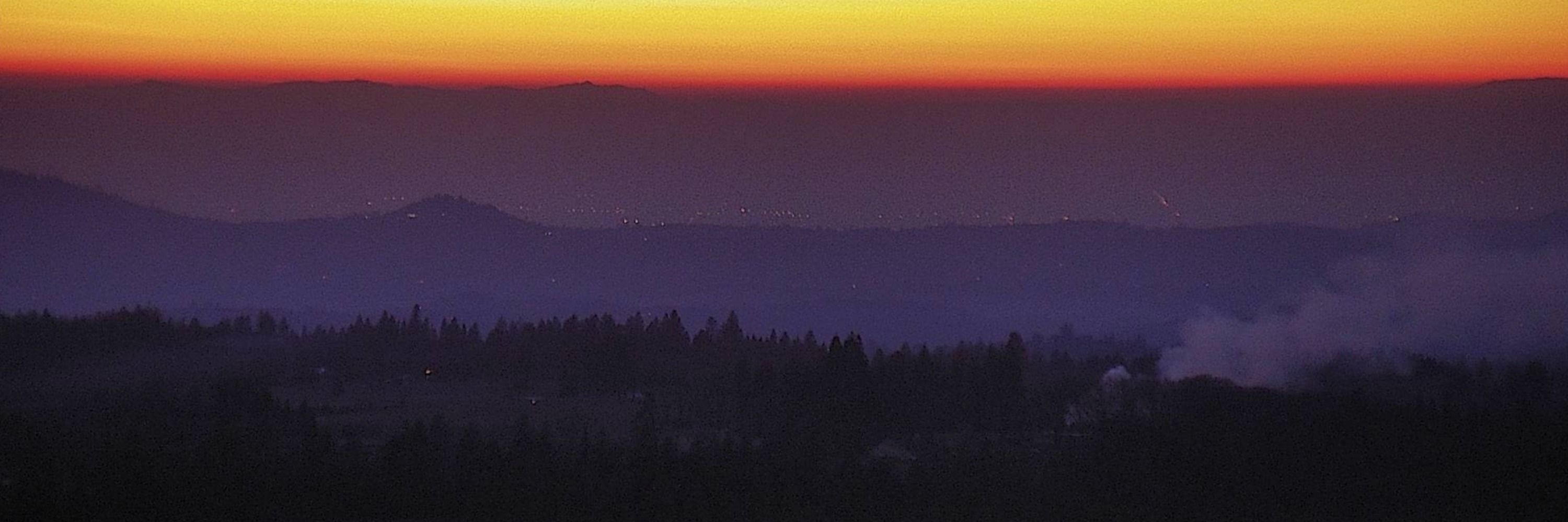
La Panza 1, SanLuisObispo County, CA
🗺35.2249, -120.1337 🧭14° ⛰3898 ft
https://ops.alertcalifornia.org/cam-console/2055
🗺35.2249, -120.1337 🧭14° ⛰3898 ft
https://ops.alertcalifornia.org/cam-console/2055
February 10, 2026 at 3:07 PM
La Panza 1, SanLuisObispo County, CA
🗺35.2249, -120.1337 🧭14° ⛰3898 ft
https://ops.alertcalifornia.org/cam-console/2055
🗺35.2249, -120.1337 🧭14° ⛰3898 ft
https://ops.alertcalifornia.org/cam-console/2055
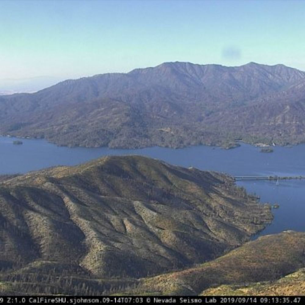
Anthony Peak Lookout 1, Mendocino County, CA
🗺39.8462, -122.9646 🧭16° ⛰6942 ft
https://ops.alertcalifornia.org/cam-console/2746
🗺39.8462, -122.9646 🧭16° ⛰6942 ft
https://ops.alertcalifornia.org/cam-console/2746

February 10, 2026 at 2:37 PM
Anthony Peak Lookout 1, Mendocino County, CA
🗺39.8462, -122.9646 🧭16° ⛰6942 ft
https://ops.alertcalifornia.org/cam-console/2746
🗺39.8462, -122.9646 🧭16° ⛰6942 ft
https://ops.alertcalifornia.org/cam-console/2746
Philo 1, Mendocino County, CA
🗺39.0637, -123.4189 🧭307° ⛰676 ft
https://ops.alertcalifornia.org/cam-console/1767
🗺39.0637, -123.4189 🧭307° ⛰676 ft
https://ops.alertcalifornia.org/cam-console/1767
February 10, 2026 at 2:08 PM
Philo 1, Mendocino County, CA
🗺39.0637, -123.4189 🧭307° ⛰676 ft
https://ops.alertcalifornia.org/cam-console/1767
🗺39.0637, -123.4189 🧭307° ⛰676 ft
https://ops.alertcalifornia.org/cam-console/1767
Mebane 1, Kern County, CA
🗺35.5161, -118.7176 🧭78° ⛰4462 ft
https://ops.alertcalifornia.org/cam-console/2113
🗺35.5161, -118.7176 🧭78° ⛰4462 ft
https://ops.alertcalifornia.org/cam-console/2113

February 10, 2026 at 1:37 PM
Mebane 1, Kern County, CA
🗺35.5161, -118.7176 🧭78° ⛰4462 ft
https://ops.alertcalifornia.org/cam-console/2113
🗺35.5161, -118.7176 🧭78° ⛰4462 ft
https://ops.alertcalifornia.org/cam-console/2113
June Mountain 2, Mono County, CA
🗺37.7482, -119.0599 🧭303° ⛰9957 ft
https://ops.alertcalifornia.org/cam-console/16666
🗺37.7482, -119.0599 🧭303° ⛰9957 ft
https://ops.alertcalifornia.org/cam-console/16666
February 10, 2026 at 1:09 PM
June Mountain 2, Mono County, CA
🗺37.7482, -119.0599 🧭303° ⛰9957 ft
https://ops.alertcalifornia.org/cam-console/16666
🗺37.7482, -119.0599 🧭303° ⛰9957 ft
https://ops.alertcalifornia.org/cam-console/16666
Mount McDill 2, LosAngeles County, CA
🗺34.5660, -118.2549 🧭60° ⛰5062 ft
https://ops.alertcalifornia.org/cam-console/2721
🗺34.5660, -118.2549 🧭60° ⛰5062 ft
https://ops.alertcalifornia.org/cam-console/2721

February 10, 2026 at 12:37 PM
Mount McDill 2, LosAngeles County, CA
🗺34.5660, -118.2549 🧭60° ⛰5062 ft
https://ops.alertcalifornia.org/cam-console/2721
🗺34.5660, -118.2549 🧭60° ⛰5062 ft
https://ops.alertcalifornia.org/cam-console/2721
Slate Mtn, Lassen County, CA
🗺40.8323, -120.8578 🧭283° ⛰6995 ft
https://ops.alertcalifornia.org/cam-console/2662
🗺40.8323, -120.8578 🧭283° ⛰6995 ft
https://ops.alertcalifornia.org/cam-console/2662
February 10, 2026 at 12:08 PM
Slate Mtn, Lassen County, CA
🗺40.8323, -120.8578 🧭283° ⛰6995 ft
https://ops.alertcalifornia.org/cam-console/2662
🗺40.8323, -120.8578 🧭283° ⛰6995 ft
https://ops.alertcalifornia.org/cam-console/2662
Coll of San Mateo Bldg10, SanMateo County, CA
🗺37.5364, -122.3353 🧭251° ⛰617 ft
https://ops.alertcalifornia.org/cam-console/1899
🗺37.5364, -122.3353 🧭251° ⛰617 ft
https://ops.alertcalifornia.org/cam-console/1899

February 10, 2026 at 11:37 AM
Coll of San Mateo Bldg10, SanMateo County, CA
🗺37.5364, -122.3353 🧭251° ⛰617 ft
https://ops.alertcalifornia.org/cam-console/1899
🗺37.5364, -122.3353 🧭251° ⛰617 ft
https://ops.alertcalifornia.org/cam-console/1899
Evora Road, ContraCosta County, CA
🗺38.0212, -121.9878 🧭88° ⛰561 ft
https://ops.alertcalifornia.org/cam-console/2592
🗺38.0212, -121.9878 🧭88° ⛰561 ft
https://ops.alertcalifornia.org/cam-console/2592
February 10, 2026 at 11:08 AM
Evora Road, ContraCosta County, CA
🗺38.0212, -121.9878 🧭88° ⛰561 ft
https://ops.alertcalifornia.org/cam-console/2592
🗺38.0212, -121.9878 🧭88° ⛰561 ft
https://ops.alertcalifornia.org/cam-console/2592
Goat Mtn Lookout 1, Madera County, CA
🗺37.2722, -119.5500 🧭10° ⛰4646 ft
https://ops.alertcalifornia.org/cam-console/16678
🗺37.2722, -119.5500 🧭10° ⛰4646 ft
https://ops.alertcalifornia.org/cam-console/16678

February 10, 2026 at 10:37 AM
Goat Mtn Lookout 1, Madera County, CA
🗺37.2722, -119.5500 🧭10° ⛰4646 ft
https://ops.alertcalifornia.org/cam-console/16678
🗺37.2722, -119.5500 🧭10° ⛰4646 ft
https://ops.alertcalifornia.org/cam-console/16678
Sonora Peak East, Tuolumne County, CA
🗺37.9799, -120.4029 🧭327° ⛰2418 ft
https://ops.alertcalifornia.org/cam-console/2405
🗺37.9799, -120.4029 🧭327° ⛰2418 ft
https://ops.alertcalifornia.org/cam-console/2405
February 10, 2026 at 10:08 AM
Sonora Peak East, Tuolumne County, CA
🗺37.9799, -120.4029 🧭327° ⛰2418 ft
https://ops.alertcalifornia.org/cam-console/2405
🗺37.9799, -120.4029 🧭327° ⛰2418 ft
https://ops.alertcalifornia.org/cam-console/2405
Wolf Mtn 1, Nevada County, CA
🗺39.1340, -121.0997 🧭324° ⛰2625 ft
https://ops.alertcalifornia.org/cam-console/1746
🗺39.1340, -121.0997 🧭324° ⛰2625 ft
https://ops.alertcalifornia.org/cam-console/1746

February 10, 2026 at 9:37 AM
Wolf Mtn 1, Nevada County, CA
🗺39.1340, -121.0997 🧭324° ⛰2625 ft
https://ops.alertcalifornia.org/cam-console/1746
🗺39.1340, -121.0997 🧭324° ⛰2625 ft
https://ops.alertcalifornia.org/cam-console/1746
Elsinore Peak 2, Riverside County, CA
🗺33.6019, -117.3439 🧭53° ⛰3504 ft
https://ops.alertcalifornia.org/cam-console/1960
🗺33.6019, -117.3439 🧭53° ⛰3504 ft
https://ops.alertcalifornia.org/cam-console/1960
February 10, 2026 at 9:08 AM
Elsinore Peak 2, Riverside County, CA
🗺33.6019, -117.3439 🧭53° ⛰3504 ft
https://ops.alertcalifornia.org/cam-console/1960
🗺33.6019, -117.3439 🧭53° ⛰3504 ft
https://ops.alertcalifornia.org/cam-console/1960
Garin Ridge 1, Alameda County, CA
🗺37.6554, -122.0027 🧭28° ⛰1503 ft
https://ops.alertcalifornia.org/cam-console/1983
🗺37.6554, -122.0027 🧭28° ⛰1503 ft
https://ops.alertcalifornia.org/cam-console/1983

February 10, 2026 at 8:37 AM
Garin Ridge 1, Alameda County, CA
🗺37.6554, -122.0027 🧭28° ⛰1503 ft
https://ops.alertcalifornia.org/cam-console/1983
🗺37.6554, -122.0027 🧭28° ⛰1503 ft
https://ops.alertcalifornia.org/cam-console/1983
Los Alamos 1, SantaBarbara County, CA
🗺34.7724, -120.3279 🧭222° ⛰899 ft
https://ops.alertcalifornia.org/cam-console/2678
🗺34.7724, -120.3279 🧭222° ⛰899 ft
https://ops.alertcalifornia.org/cam-console/2678
February 10, 2026 at 8:08 AM
Los Alamos 1, SantaBarbara County, CA
🗺34.7724, -120.3279 🧭222° ⛰899 ft
https://ops.alertcalifornia.org/cam-console/2678
🗺34.7724, -120.3279 🧭222° ⛰899 ft
https://ops.alertcalifornia.org/cam-console/2678
Chino Hills 1, Orange County, CA
🗺33.9138, -117.7383 🧭12° ⛰1749 ft
https://ops.alertcalifornia.org/cam-console/1894
🗺33.9138, -117.7383 🧭12° ⛰1749 ft
https://ops.alertcalifornia.org/cam-console/1894

February 10, 2026 at 7:37 AM
Chino Hills 1, Orange County, CA
🗺33.9138, -117.7383 🧭12° ⛰1749 ft
https://ops.alertcalifornia.org/cam-console/1894
🗺33.9138, -117.7383 🧭12° ⛰1749 ft
https://ops.alertcalifornia.org/cam-console/1894
Sonora Peak East, Tuolumne County, CA
🗺37.9799, -120.4029 🧭330° ⛰2418 ft
https://ops.alertcalifornia.org/cam-console/2405
🗺37.9799, -120.4029 🧭330° ⛰2418 ft
https://ops.alertcalifornia.org/cam-console/2405
February 10, 2026 at 7:08 AM
Sonora Peak East, Tuolumne County, CA
🗺37.9799, -120.4029 🧭330° ⛰2418 ft
https://ops.alertcalifornia.org/cam-console/2405
🗺37.9799, -120.4029 🧭330° ⛰2418 ft
https://ops.alertcalifornia.org/cam-console/2405
Chino Hills 2, Orange County, CA
🗺33.9138, -117.7383 🧭240° ⛰1749 ft
https://ops.alertcalifornia.org/cam-console/1895
🗺33.9138, -117.7383 🧭240° ⛰1749 ft
https://ops.alertcalifornia.org/cam-console/1895

February 10, 2026 at 6:37 AM
Chino Hills 2, Orange County, CA
🗺33.9138, -117.7383 🧭240° ⛰1749 ft
https://ops.alertcalifornia.org/cam-console/1895
🗺33.9138, -117.7383 🧭240° ⛰1749 ft
https://ops.alertcalifornia.org/cam-console/1895
Cedar Canyon 1, Kern County, CA
🗺35.4876, -120.0184 🧭350° ⛰2966 ft
https://ops.alertcalifornia.org/cam-console/2727
🗺35.4876, -120.0184 🧭350° ⛰2966 ft
https://ops.alertcalifornia.org/cam-console/2727
February 10, 2026 at 6:08 AM
Cedar Canyon 1, Kern County, CA
🗺35.4876, -120.0184 🧭350° ⛰2966 ft
https://ops.alertcalifornia.org/cam-console/2727
🗺35.4876, -120.0184 🧭350° ⛰2966 ft
https://ops.alertcalifornia.org/cam-console/2727
Palo Escrito 2, Monterey County, CA
🗺36.4064, -121.4914 🧭105° ⛰4416 ft
https://ops.alertcalifornia.org/cam-console/2238
🗺36.4064, -121.4914 🧭105° ⛰4416 ft
https://ops.alertcalifornia.org/cam-console/2238

February 10, 2026 at 5:37 AM
Palo Escrito 2, Monterey County, CA
🗺36.4064, -121.4914 🧭105° ⛰4416 ft
https://ops.alertcalifornia.org/cam-console/2238
🗺36.4064, -121.4914 🧭105° ⛰4416 ft
https://ops.alertcalifornia.org/cam-console/2238
Los Pinos South, SanDiego County, CA
🗺32.7347, -116.5778 🧭212° ⛰4774 ft
https://ops.alertcalifornia.org/cam-console/2087
🗺32.7347, -116.5778 🧭212° ⛰4774 ft
https://ops.alertcalifornia.org/cam-console/2087
February 10, 2026 at 5:08 AM
Los Pinos South, SanDiego County, CA
🗺32.7347, -116.5778 🧭212° ⛰4774 ft
https://ops.alertcalifornia.org/cam-console/2087
🗺32.7347, -116.5778 🧭212° ⛰4774 ft
https://ops.alertcalifornia.org/cam-console/2087
Mt Abel 1, Kern County, CA
🗺34.8291, -119.2040 🧭196° ⛰8264 ft
https://ops.alertcalifornia.org/cam-console/2142
🗺34.8291, -119.2040 🧭196° ⛰8264 ft
https://ops.alertcalifornia.org/cam-console/2142

February 10, 2026 at 4:37 AM
Mt Abel 1, Kern County, CA
🗺34.8291, -119.2040 🧭196° ⛰8264 ft
https://ops.alertcalifornia.org/cam-console/2142
🗺34.8291, -119.2040 🧭196° ⛰8264 ft
https://ops.alertcalifornia.org/cam-console/2142
Pinole Ridge, ContraCosta County, CA
🗺37.9932, -122.2697 🧭200° ⛰545 ft
https://ops.alertcalifornia.org/cam-console/2258
🗺37.9932, -122.2697 🧭200° ⛰545 ft
https://ops.alertcalifornia.org/cam-console/2258
February 10, 2026 at 4:08 AM
Pinole Ridge, ContraCosta County, CA
🗺37.9932, -122.2697 🧭200° ⛰545 ft
https://ops.alertcalifornia.org/cam-console/2258
🗺37.9932, -122.2697 🧭200° ⛰545 ft
https://ops.alertcalifornia.org/cam-console/2258
Red Corral Rd 2, Amador County, CA
🗺38.4130, -120.5952 🧭90° ⛰3107 ft
https://ops.alertcalifornia.org/cam-console/2301
🗺38.4130, -120.5952 🧭90° ⛰3107 ft
https://ops.alertcalifornia.org/cam-console/2301

February 10, 2026 at 3:37 AM
Red Corral Rd 2, Amador County, CA
🗺38.4130, -120.5952 🧭90° ⛰3107 ft
https://ops.alertcalifornia.org/cam-console/2301
🗺38.4130, -120.5952 🧭90° ⛰3107 ft
https://ops.alertcalifornia.org/cam-console/2301
Bryant Canyon 1, Monterey County, CA
🗺36.4595, -121.2996 🧭141° ⛰1224 ft
https://ops.alertcalifornia.org/cam-console/2747
🗺36.4595, -121.2996 🧭141° ⛰1224 ft
https://ops.alertcalifornia.org/cam-console/2747
February 10, 2026 at 3:08 AM
Bryant Canyon 1, Monterey County, CA
🗺36.4595, -121.2996 🧭141° ⛰1224 ft
https://ops.alertcalifornia.org/cam-console/2747
🗺36.4595, -121.2996 🧭141° ⛰1224 ft
https://ops.alertcalifornia.org/cam-console/2747