Simon Brewer
banner
stormgasm.bsky.social
Simon Brewer
@stormgasm.bsky.social

Meteorologist, Storm Chaser, Journalist & Photographer: Hurricanes, Tornadoes, & Winter Storms
www.stormgasm.com

Environmental science 47%
Geology 23%

Aurora Borealis shining over... Dayton, Ohio tonight!!!
Beautiful colors!
What a powerful solar storm!
#ohwx

NEW VIDEO from a HUMAN!!!
Indiana Lake Effect Snow:
First decent lake effect snow event of the season over Northwest Indiana
#inwx
youtu.be/gUX5HbQpIvE?...

First snowflakes of the season mixing with some rain over the Eastside of Dayton, Ohio at 4:00 pm EST on November 9, 2025. #ohwx #snow

Just a reminder the National Debt crisis and resulting government shutdown was created by the unnecessary massive tax cuts for the Top 0.1%

Trickle Down Economics doesn't work

November might be the most interesting month for extreme weather in the USA. Potential for tornadoes, hurricanes, Nor'easters, and intense lake effect snow.
#November

Happy Halloween 2025!!!

Reposted by Simon Brewer

JD Vance is lying. He knows he’s lying. But he doesn’t care. Trump has taught Vance & all the others in my former political party that the truth doesn’t matter.

Certain the US Government could've sold every brick and window of the White House East Wing as historical momentos and cherished keepsakes to and for the US Citizens/Tax Payers, instead of just obliterating and trashing a historical structure... but what do I know! SMH
#stupid

Reposted by Simon Brewer

October 29-30th, 2011:
A nor'easter swept up the Appalachians into New England. Over a foot of snow fell from West Virginia to Maine, with more than two feet in Massachusetts and New Hampshire mountains. Winds over 50 mph were reported on Nantucket Island and Martha's Vineyard.

Something like this hasn't happened since 1935: a high-end, sub-900mb CAT 5 Tropical Cyclone made landfall at/near peak intensity in the Atlantic Basin. The October 28, 2025 Hurricane Melissa Jamaica landfall event is a rare meteorological moment in history.

Appears CAT 5 Hurricane Melissa made landfall near New Hope, Jamaica with an incredibly low estimated minimum central pressure of 892 mb and devastating maximum sustained winds of 185 mph with higher gusts possibly exceeding 200 mph. Also, tornado or tornado-like whirls possible!

Have to wonder if the Jamaican high terrain and/or trochoidal wobbles will have a significant impact on the potential landfall location of CAT 5 Hurricane Melissa. Localized enhanced steering currents can develop between the core of tropical cyclones and high terrain islands...

Incredible outflow channel ventilation for CAT 5 Hurricane Melissa over the Caribbean.
The most intense tropical cyclones typically have massive outflow channels like these.
October 27, 2025 #Jamaica

Reposted by Simon Brewer

Even with all of the structural, intensity, and SST/OHC changes underneath Hurricane #Melissa the last few days, the diurnal cycle still remains undefeated and inevitable
Lightning flashes within the powerful eye wall of Hurricane Melissa.

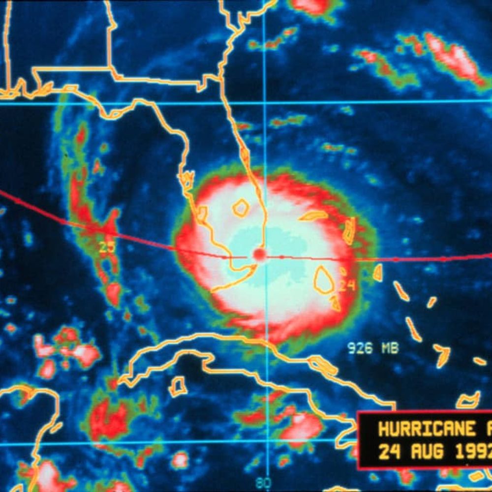
Incredible imagery this morning of Melissa, a Category 5 storm, south of Jamaica.

CAT 5 Hurricane Melissa looks incredibly intense on satellite just south of Jamaica. The storm is likely to turn north today and tomorrow and cause catastrophic damage over Jamaica as a powerhouse.

Reposted by Simon Brewer

October 26th, 2010:

A dynamic extratropical cyclone produced a wide array of significant weather events in the central & eastern US. 63 twisters and hundreds of damaging wind reports were spawned by a high risk derecho event & tornado outbreak. In the Upper Midwest, a blizzard occurred.
1/2

#weatherpicofday
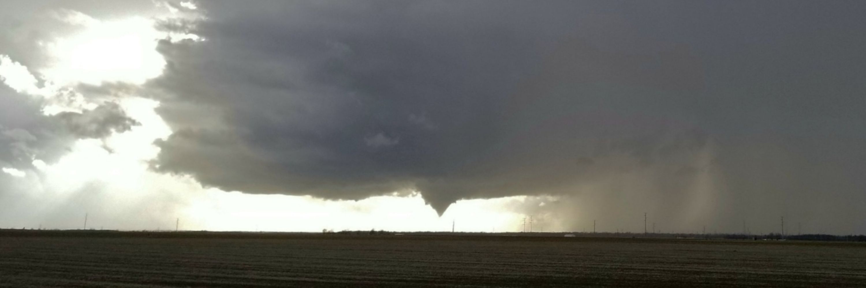
Documented 7 tornadoes over Southwest Kansas between the communities of Dodge City and Cold Water during a regional coldcore outbreak OTD 19 years ago, October 26, 2006. Most were landspout variety with triplets at one point. w/ Mark McGowan #KSwx

Hurricane Melissa looks like an absolute beast this morning. It appears to slowly be chugging toward Jamaica and then Cuba the next few days. These islands will probably get incredible amounts of rainfall likely resulting in devastating floods and mudslides. #HurricaneMelissa

Warm-up those cars before you head out this morning! Freeze/frost out there!
Dayton, Ohio October 24, 2025 #ohwx

Fall colors are popping!
October 22, 2025 Dayton, Ohio
#ohwx

OTD 25 years ago, October 22, 2000, I saw my first tornado over the Southeast-side of Oklahoma City, OK with friend and fellow newbie storm chaser Jim Bishop.
Saw powerflashes from a tornado near Crossroads Mall. Later, we were hit by possibly the same circulation northeast of the mall. #OKwx

OTD 3 year ago tonight, October, 22, 2022, I was in Nayarit, Mexico waiting for Category 4 #Hurricane #Roslyn. It made landfall during early morning hours the following day, the 23rd, as a strong CAT 3.
Please watch the chase video below:
youtu.be/UGIByoYXqoo?...
NEWS: Arizona Attorney General Kris Mayes and Rep.-Elect Adelita Grijalva have SUED the U.S. House of Representatives in federal court in Washington, D.C. over Speaker Mike Johnson’s refusal to swear in Grijalva.

Grijalva would be the 218th vote for the Epstein Files discharge petition.

Found Comet Lemmon!
Crappie cell phone long exposure.
Will pull out thd bigger guns in a few days to better capture this ball of ice and dust.
#ohwx

Only way to move forward is to have as many on-board the 'Progress Freedom Train' as possible.

Reposted by Simon Brewer

October 18, 2007:

A significant outbreak of over forty tornadoes impacted numerous states from the Gulf Coast to the Great Lakes. Seventeen tornadoes were significant (EF2+), three of which were rated EF3. Five people were killed and 25 were injured.

OTD 7 years ago, October 10, 2018,
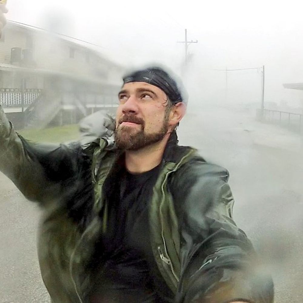
@JustonStrmRider and I rode-out the intense right 'eyewall' of devastating CAT 5 Hurricane Michael in Mexico Beach, Florida. We barely stayed above a rushing 15 foot storm surge.
VIDEO LINK BELOW:
youtu.be/XdTRboLzoUo?...

First frost of the season in Dayton, Ohio (October 10, 2025). Relatively close reporting ASOS stations are at 40°F, but that's at 10 meters or ~30 feet elevation. The metal roofs of cars radiate heat more efficiently at lower elevation, so the morning dew froze. #ohwx #frostwarning

#weatherpicofday
OTD 24 years ago Jim Bishop and I documented 2 twisters and several supercells during little outbreak in Western Oklahoma. Incredible how many years have passed!
#okwx