


WSF M/V Chimacum docking at Vashon ferry terminal, 07NOV2025.

November 7, 2025 at 3:05 PM
WSF M/V Chimacum docking at Vashon ferry terminal, 07NOV2025.

On my mother’s birthday I do things she'd have enjoyed. It was a golden autumn day perfect for interisland ferry knitting. The sky was magnificent, and my Dignity Cap design sample is ready for crown decreases. Happy birthday, Mama.
#FerryKnitting #IslandLife #DignityCap #GayKnitter #RealMenKnit
#FerryKnitting #IslandLife #DignityCap #GayKnitter #RealMenKnit


October 9, 2025 at 11:30 PM
On my mother’s birthday I do things she'd have enjoyed. It was a golden autumn day perfect for interisland ferry knitting. The sky was magnificent, and my Dignity Cap design sample is ready for crown decreases. Happy birthday, Mama.
#FerryKnitting #IslandLife #DignityCap #GayKnitter #RealMenKnit
#FerryKnitting #IslandLife #DignityCap #GayKnitter #RealMenKnit
examples for eight cities
demonstrating the amount of spatial detail present (but scarcely visible) in the global map.
“height” in the pseudo-3D maps
indicates building mass per 90 m pixel
demonstrating the amount of spatial detail present (but scarcely visible) in the global map.
“height” in the pseudo-3D maps
indicates building mass per 90 m pixel

September 30, 2025 at 7:00 PM
examples for eight cities
demonstrating the amount of spatial detail present (but scarcely visible) in the global map.
“height” in the pseudo-3D maps
indicates building mass per 90 m pixel
demonstrating the amount of spatial detail present (but scarcely visible) in the global map.
“height” in the pseudo-3D maps
indicates building mass per 90 m pixel
Alki (with M/V Kaleetan passing by) as seen from the M/V Tacoma. Taken 08/29/2025.

September 25, 2025 at 5:28 PM
Alki (with M/V Kaleetan passing by) as seen from the M/V Tacoma. Taken 08/29/2025.
View of downtown Seattle as seen from WSF M/V Tacoma, 08/29/2025.

September 16, 2025 at 3:40 PM
View of downtown Seattle as seen from WSF M/V Tacoma, 08/29/2025.
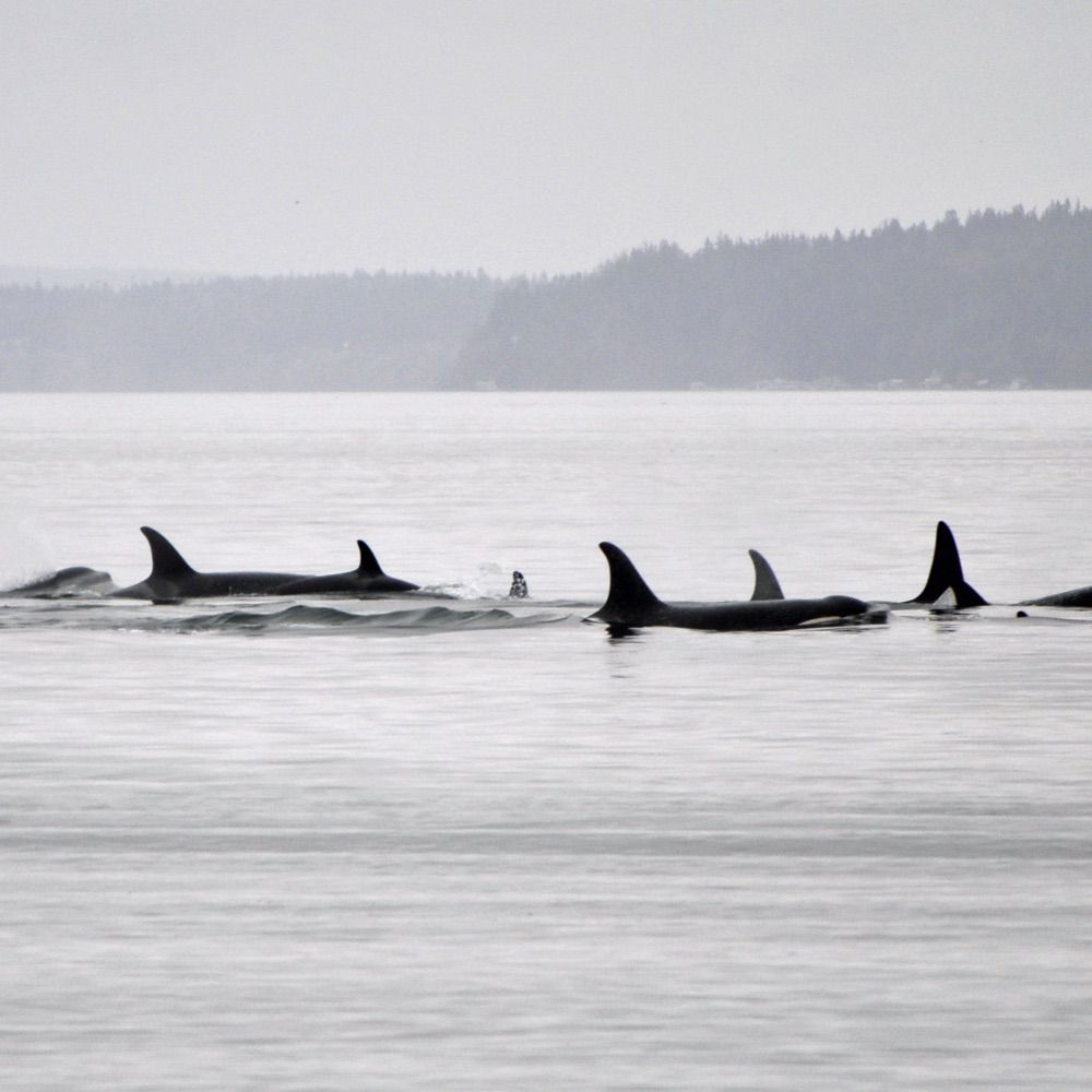
🐬 ORCAS - Central Puget Sound
Northbound in Colvos Passage this morning, then:
Last confirmed sighting: 09:26- M/V Sealth reports sighting of orca pod in the vicinity of Southworth. [WSF via oncg]
10:09 - report of 2 orcas southbound towards Pt Robinson, but location not included.
#psws
Northbound in Colvos Passage this morning, then:
Last confirmed sighting: 09:26- M/V Sealth reports sighting of orca pod in the vicinity of Southworth. [WSF via oncg]
10:09 - report of 2 orcas southbound towards Pt Robinson, but location not included.
#psws
September 1, 2025 at 5:36 PM
🐬 ORCAS - Central Puget Sound
Northbound in Colvos Passage this morning, then:
Last confirmed sighting: 09:26- M/V Sealth reports sighting of orca pod in the vicinity of Southworth. [WSF via oncg]
10:09 - report of 2 orcas southbound towards Pt Robinson, but location not included.
#psws
Northbound in Colvos Passage this morning, then:
Last confirmed sighting: 09:26- M/V Sealth reports sighting of orca pod in the vicinity of Southworth. [WSF via oncg]
10:09 - report of 2 orcas southbound towards Pt Robinson, but location not included.
#psws

Quick video shot on Folly Beach touching on the Warrior Surf Foundation. #WSF #WarriorSurfFoundation youtube.com/shorts/bqZ-m...

Warrior Surf Foundations E-21 My Parkinson Journey
YouTube video by MyParkinsonJourney
youtube.com
August 20, 2025 at 7:18 PM
Quick video shot on Folly Beach touching on the Warrior Surf Foundation. #WSF #WarriorSurfFoundation youtube.com/shorts/bqZ-m...

この記事↓から、海軍がNOAAへの衛星データ提供の継続を決めた件の細かい部分が見えてくる。
・防衛気象衛星プログラム(DMSP)のデータ提供は2026年9月まで延長
・DMSP衛星は、1962年から50年以上使用されており、1日2回地球全体の画像を撮影
・国防総省は既に2回期限を延長。近代化計画の一環として段階的廃止を計画していたが、今回、再び方針転換
・今後の代替システムはWSF-M(Weather System Follow-On Microwave)。2024年に打ち上げられた新システムはより詳細な分析が可能(3/3)
www.navytimes.com/news/your-mi...
・防衛気象衛星プログラム(DMSP)のデータ提供は2026年9月まで延長
・DMSP衛星は、1962年から50年以上使用されており、1日2回地球全体の画像を撮影
・国防総省は既に2回期限を延長。近代化計画の一環として段階的廃止を計画していたが、今回、再び方針転換
・今後の代替システムはWSF-M(Weather System Follow-On Microwave)。2024年に打ち上げられた新システムはより詳細な分析が可能(3/3)
www.navytimes.com/news/your-mi...

In reversal, Navy will share satellite data with NOAA until fall 2026
The Navy will continue sharing data with NOAA from satellites that the service had planned to start phasing out on July 31.
www.navytimes.com
August 1, 2025 at 9:03 PM
この記事↓から、海軍がNOAAへの衛星データ提供の継続を決めた件の細かい部分が見えてくる。
・防衛気象衛星プログラム(DMSP)のデータ提供は2026年9月まで延長
・DMSP衛星は、1962年から50年以上使用されており、1日2回地球全体の画像を撮影
・国防総省は既に2回期限を延長。近代化計画の一環として段階的廃止を計画していたが、今回、再び方針転換
・今後の代替システムはWSF-M(Weather System Follow-On Microwave)。2024年に打ち上げられた新システムはより詳細な分析が可能(3/3)
www.navytimes.com/news/your-mi...
・防衛気象衛星プログラム(DMSP)のデータ提供は2026年9月まで延長
・DMSP衛星は、1962年から50年以上使用されており、1日2回地球全体の画像を撮影
・国防総省は既に2回期限を延長。近代化計画の一環として段階的廃止を計画していたが、今回、再び方針転換
・今後の代替システムはWSF-M(Weather System Follow-On Microwave)。2024年に打ち上げられた新システムはより詳細な分析が可能(3/3)
www.navytimes.com/news/your-mi...

7/31 we honored terminal attendants – Carol Stearns & Frank “Bill” Fletcher – for 50 years at WSF. We temporarily named #Kaleetan on Seattle/Bremerton route the M/V Carol Stearns & #Kennewick on Port Townsend/Coupeville run the M/V Frank Fletcher. Thank you Carol and Frank!


August 1, 2025 at 5:49 PM
7/31 we honored terminal attendants – Carol Stearns & Frank “Bill” Fletcher – for 50 years at WSF. We temporarily named #Kaleetan on Seattle/Bremerton route the M/V Carol Stearns & #Kennewick on Port Townsend/Coupeville run the M/V Frank Fletcher. Thank you Carol and Frank!

Y'all - do a little research before assuming doom and gloom.
Apparently, the satellite data that is being phased out is obsolete compared to a new WSF-M satellite that has become operational this spring.
Source: www.militarytimes.com/news/your-mi...
Apparently, the satellite data that is being phased out is obsolete compared to a new WSF-M satellite that has become operational this spring.
Source: www.militarytimes.com/news/your-mi...
July 29, 2025 at 2:04 PM
Y'all - do a little research before assuming doom and gloom.
Apparently, the satellite data that is being phased out is obsolete compared to a new WSF-M satellite that has become operational this spring.
Source: www.militarytimes.com/news/your-mi...
Apparently, the satellite data that is being phased out is obsolete compared to a new WSF-M satellite that has become operational this spring.
Source: www.militarytimes.com/news/your-mi...

Flight: #myj25
Registration: YR-WSF
ICAO code: #4a5e66
Type: SF50
Speed: 353 kmh
Altitude: 2758 m
Distance: 7.4 km
Angle ∆: 20.4°
Direction ->: SSE
Track:
https://tinyurl.com/242qcbnp
History:
https://www.radarbox.com/data/mode-s/4A5E66
https://www.flightradar24.com/data/aircraft/YR-WSF
Photos […]
Registration: YR-WSF
ICAO code: #4a5e66
Type: SF50
Speed: 353 kmh
Altitude: 2758 m
Distance: 7.4 km
Angle ∆: 20.4°
Direction ->: SSE
Track:
https://tinyurl.com/242qcbnp
History:
https://www.radarbox.com/data/mode-s/4A5E66
https://www.flightradar24.com/data/aircraft/YR-WSF
Photos […]
Original post on mastodon.social
mastodon.social
July 27, 2025 at 12:09 PM
Flight: #myj25
Registration: YR-WSF
ICAO code: #4a5e66
Type: SF50
Speed: 353 kmh
Altitude: 2758 m
Distance: 7.4 km
Angle ∆: 20.4°
Direction ->: SSE
Track:
https://tinyurl.com/242qcbnp
History:
https://www.radarbox.com/data/mode-s/4A5E66
https://www.flightradar24.com/data/aircraft/YR-WSF
Photos […]
Registration: YR-WSF
ICAO code: #4a5e66
Type: SF50
Speed: 353 kmh
Altitude: 2758 m
Distance: 7.4 km
Angle ∆: 20.4°
Direction ->: SSE
Track:
https://tinyurl.com/242qcbnp
History:
https://www.radarbox.com/data/mode-s/4A5E66
https://www.flightradar24.com/data/aircraft/YR-WSF
Photos […]

A major setback came with the loss of satellite microwave data from the U.S. military’s DMSP system, which NOAA relied on for nighttime storm observations. Its replacement, WSF‑M, is delayed.
July 13, 2025 at 8:42 PM
A major setback came with the loss of satellite microwave data from the U.S. military’s DMSP system, which NOAA relied on for nighttime storm observations. Its replacement, WSF‑M, is delayed.

This means weather centers could very well use #SatDump to still get the data they need for hurricane analysis, right now, in real time, with simple equipment. WSF-M also coming.
@weatherprof.bsky.social @michaelrlowry.bsky.social @rarohde.bsky.social @altnoaa.bsky.social
bsky.app/profile/aang...
@weatherprof.bsky.social @michaelrlowry.bsky.social @rarohde.bsky.social @altnoaa.bsky.social
bsky.app/profile/aang...

It was recently announced that DMSP SSMIS data wouldn't be available - so with @lego11.bsky.social we decided to add support in SatDump :-)
Still lacking more samples (IQ) to do projections, but we can already process SSMIS data. Calibration is likely possible as well.
Still lacking more samples (IQ) to do projections, but we can already process SSMIS data. Calibration is likely possible as well.


July 12, 2025 at 12:13 PM
This means weather centers could very well use #SatDump to still get the data they need for hurricane analysis, right now, in real time, with simple equipment. WSF-M also coming.
@weatherprof.bsky.social @michaelrlowry.bsky.social @rarohde.bsky.social @altnoaa.bsky.social
bsky.app/profile/aang...
@weatherprof.bsky.social @michaelrlowry.bsky.social @rarohde.bsky.social @altnoaa.bsky.social
bsky.app/profile/aang...
Here are the facts:
As the Defense Department transfers greater reliance onto the newly fielded Weather System Follow-on Microwave, or WSF-M, use of the decades-old DMSPs for weather monitoring is being rapidly phased out.
www.militarytimes.com/news/your-mi...
As the Defense Department transfers greater reliance onto the newly fielded Weather System Follow-on Microwave, or WSF-M, use of the decades-old DMSPs for weather monitoring is being rapidly phased out.
www.militarytimes.com/news/your-mi...

Navy to stop sharing satellite weather data with NOAA
While Defense Meteorological Satellite Program data will no longer be provided to NOAA, the agency has not lost all access to global weather imaging.
www.militarytimes.com
July 6, 2025 at 11:25 PM
Here are the facts:
As the Defense Department transfers greater reliance onto the newly fielded Weather System Follow-on Microwave, or WSF-M, use of the decades-old DMSPs for weather monitoring is being rapidly phased out.
www.militarytimes.com/news/your-mi...
As the Defense Department transfers greater reliance onto the newly fielded Weather System Follow-on Microwave, or WSF-M, use of the decades-old DMSPs for weather monitoring is being rapidly phased out.
www.militarytimes.com/news/your-mi...

"NOAA will now rely on data and imagery provided by WSF-M as well as the Electro-Optical Weather System, or EWS, to replace the DMSP data, according to its July release.
"“DMSP satellites remain operational today but are more than a decade past their expected end of life,” the release said."
"“DMSP satellites remain operational today but are more than a decade past their expected end of life,” the release said."
July 6, 2025 at 6:39 AM
"NOAA will now rely on data and imagery provided by WSF-M as well as the Electro-Optical Weather System, or EWS, to replace the DMSP data, according to its July release.
"“DMSP satellites remain operational today but are more than a decade past their expected end of life,” the release said."
"“DMSP satellites remain operational today but are more than a decade past their expected end of life,” the release said."
"The WSF-M, a more modern system that can pinpoint developing weather data more exactly, was declared to have reached Initial Operational Capacity this April. The WSF-M, first launched in 2024, can analyze sea ice, soil moisture and snow depth, as well as measure winds and collect cyclone data.
July 6, 2025 at 6:39 AM
"The WSF-M, a more modern system that can pinpoint developing weather data more exactly, was declared to have reached Initial Operational Capacity this April. The WSF-M, first launched in 2024, can analyze sea ice, soil moisture and snow depth, as well as measure winds and collect cyclone data.
Reading is fundamental
"As the Defense Department transfers greater reliance onto the newly fielded Weather System Follow-on Microwave, or WSF-M, use of the decades-old DMSPs for weather monitoring is being rapidly phased out."
"As the Defense Department transfers greater reliance onto the newly fielded Weather System Follow-on Microwave, or WSF-M, use of the decades-old DMSPs for weather monitoring is being rapidly phased out."
July 6, 2025 at 6:39 AM
Reading is fundamental
"As the Defense Department transfers greater reliance onto the newly fielded Weather System Follow-on Microwave, or WSF-M, use of the decades-old DMSPs for weather monitoring is being rapidly phased out."
"As the Defense Department transfers greater reliance onto the newly fielded Weather System Follow-on Microwave, or WSF-M, use of the decades-old DMSPs for weather monitoring is being rapidly phased out."

www.militarytimes.com/news/your-mi...
I have an acronym for WSF-M & EWS 💪💗 Hope it’s better 👟
I have an acronym for WSF-M & EWS 💪💗 Hope it’s better 👟

Navy to stop sharing satellite weather data with NOAA
While Defense Meteorological Satellite Program data will no longer be provided to NOAA, the agency has not lost all access to global weather imaging.
www.militarytimes.com
July 6, 2025 at 2:53 AM
www.militarytimes.com/news/your-mi...
I have an acronym for WSF-M & EWS 💪💗 Hope it’s better 👟
I have an acronym for WSF-M & EWS 💪💗 Hope it’s better 👟

The whole thing raises more questions than it answers. The satellites work. Why not keep the data flowing to the scientists who use them to forecast some of the deadliest storms on earth? And no one WSF-M satellite doesn't solve this and right now we don't have access to that data regardless.
June 30, 2025 at 2:41 PM
The whole thing raises more questions than it answers. The satellites work. Why not keep the data flowing to the scientists who use them to forecast some of the deadliest storms on earth? And no one WSF-M satellite doesn't solve this and right now we don't have access to that data regardless.

The USSF has awarded the launch of the USSF-178 to SpaceX under NSSL Phase 3 Lane 1! It'll carry the 2nd WSF-M satellite, the 1st of which launched aboard USSF-62 last year. Scheduled for 2027, USSF-178 will also carry BLAZE-2 comprising of rideshares to be selected later. t.co/06PGKGxKzL

June 28, 2025 at 7:42 PM
The USSF has awarded the launch of the USSF-178 to SpaceX under NSSL Phase 3 Lane 1! It'll carry the 2nd WSF-M satellite, the 1st of which launched aboard USSF-62 last year. Scheduled for 2027, USSF-178 will also carry BLAZE-2 comprising of rideshares to be selected later. t.co/06PGKGxKzL

Thanks to Scott for answering about whether data from the military's WSF-M satellite microwave will be available to civilians. It sounds like there's some plans, which is good - but from the little I can find on the web about the WSF-M instrument it does not seem like a real replacement for SSMIS.

My sources here at CIMSS tell me that it should be soon, since cal/val is now complete and NOAA signed off on data release recently.
June 28, 2025 at 6:09 PM
Thanks to Scott for answering about whether data from the military's WSF-M satellite microwave will be available to civilians. It sounds like there's some plans, which is good - but from the little I can find on the web about the WSF-M instrument it does not seem like a real replacement for SSMIS.
Apparently:”Weather System Follow-on Microwave (WSF-M) is DoD's replacement for DMSP. The 1st satellite (WSF-M1) was launched in April 2024, and is Operational. The 2nd satellite is planned for no earlier than 2028.”
June 27, 2025 at 11:02 PM
Apparently:”Weather System Follow-on Microwave (WSF-M) is DoD's replacement for DMSP. The 1st satellite (WSF-M1) was launched in April 2024, and is Operational. The 2nd satellite is planned for no earlier than 2028.”
Does anyone know if the civilian world is (or was ever) slated to get data from the WSF-M satellite? It's operational now apparently.
www.ssc.spaceforce.mil/Newsroom/Art...
www.ssc.spaceforce.mil/Newsroom/Art...
www.ssc.spaceforce.mil
June 27, 2025 at 9:58 PM
Does anyone know if the civilian world is (or was ever) slated to get data from the WSF-M satellite? It's operational now apparently.
www.ssc.spaceforce.mil/Newsroom/Art...
www.ssc.spaceforce.mil/Newsroom/Art...