


Also more accessible NYC Floodmapping,
For the dystopia to work I mostly need to use the 500 Year Flood zones dcp.maps.arcgis.com/apps/webappv...
For the dystopia to work I mostly need to use the 500 Year Flood zones dcp.maps.arcgis.com/apps/webappv...
ArcGIS Web Application
dcp.maps.arcgis.com
November 6, 2025 at 6:26 PM
Also more accessible NYC Floodmapping,
For the dystopia to work I mostly need to use the 500 Year Flood zones dcp.maps.arcgis.com/apps/webappv...
For the dystopia to work I mostly need to use the 500 Year Flood zones dcp.maps.arcgis.com/apps/webappv...

🗺️ This unified framework leverages the full diversity of available satellite imagery for more reliable #floodmapping.
August 7, 2025 at 8:32 AM
🗺️ This unified framework leverages the full diversity of available satellite imagery for more reliable #floodmapping.
I pointed this out a few days ago about Camp Mystic.
(The graphics here are essentially the same as the final assignment I gave the GIS class I taught at a local University last semester, except I had them do parts of Asheville, NC after Helene).
#gis #fema #floodmapping #txdisaster #disasters
(The graphics here are essentially the same as the final assignment I gave the GIS class I taught at a local University last semester, except I had them do parts of Asheville, NC after Helene).
#gis #fema #floodmapping #txdisaster #disasters


July 10, 2025 at 3:54 PM
I pointed this out a few days ago about Camp Mystic.
(The graphics here are essentially the same as the final assignment I gave the GIS class I taught at a local University last semester, except I had them do parts of Asheville, NC after Helene).
#gis #fema #floodmapping #txdisaster #disasters
(The graphics here are essentially the same as the final assignment I gave the GIS class I taught at a local University last semester, except I had them do parts of Asheville, NC after Helene).
#gis #fema #floodmapping #txdisaster #disasters

📢 Join us at the NRCan Western #Canada #FloodMapping Conference on Feb 19, 2025!
✅ Gain insights into the latest advancements from leading experts
✅ Network with government practitioners and industry experts
✅ Contribute to harmonizing best practices
Details: climatewest.ca/western-floo...
✅ Gain insights into the latest advancements from leading experts
✅ Network with government practitioners and industry experts
✅ Contribute to harmonizing best practices
Details: climatewest.ca/western-floo...

Western Flood Mapping Conference
Share knowledge, experience, and innovative approaches to flood mapping in Canada at the Western Flood Mapping Conference, February 19, 2025.
climatewest.ca
December 20, 2024 at 1:48 PM
📢 Join us at the NRCan Western #Canada #FloodMapping Conference on Feb 19, 2025!
✅ Gain insights into the latest advancements from leading experts
✅ Network with government practitioners and industry experts
✅ Contribute to harmonizing best practices
Details: climatewest.ca/western-floo...
✅ Gain insights into the latest advancements from leading experts
✅ Network with government practitioners and industry experts
✅ Contribute to harmonizing best practices
Details: climatewest.ca/western-floo...


Happy to see some of our work with UPEI shared in the catastrophe modeling & management community!
#pluvialflooding #climatechange #coastalregions #floodmapping
#pluvialflooding #climatechange #coastalregions #floodmapping

Pluvial flood modeling for coastal areas under future climate change – A case study for Prince Edward Island, Canada
www.sciencedirect.com/science/arti...
www.sciencedirect.com/science/arti...

Pluvial flood modeling for coastal areas under future climate change – A case study for Prince Edward Island, Canada
It has been increasingly understood that pluvial flooding poses a substantial risk to numerous communities across the globe. This is especially releva…
www.sciencedirect.com
February 4, 2025 at 12:55 AM
Happy to see some of our work with UPEI shared in the catastrophe modeling & management community!
#pluvialflooding #climatechange #coastalregions #floodmapping
#pluvialflooding #climatechange #coastalregions #floodmapping

A stunning new global map reveals how rivers truly flow—reshaping flood prediction and climate planning worldwide. #ClimateResilience #FloodMapping #WaterSecurity
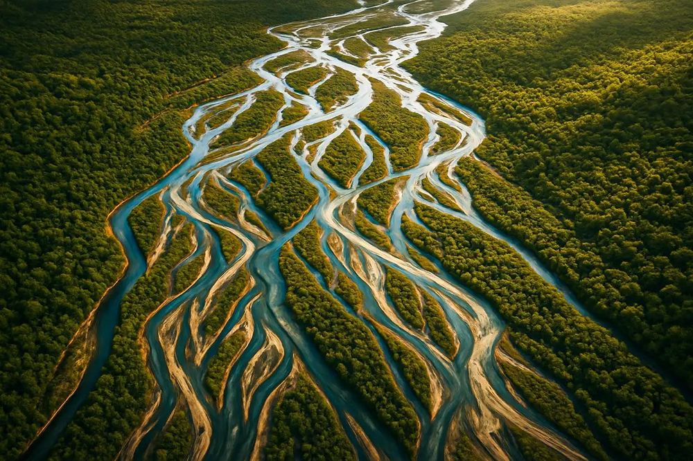
How Rivers Really Flow: A Bold New Global Map
Oxford researchers have redefined how we map the planet’s rivers—revealing intricate flow patterns and branches that could revolutionize flood prediction and climate resilience planning.
geekoo.news
May 18, 2025 at 9:22 AM
A stunning new global map reveals how rivers truly flow—reshaping flood prediction and climate planning worldwide. #ClimateResilience #FloodMapping #WaterSecurity


5/5 Varun is my 6th PhD student as a major advisor—and my 3rd since returning to the US five years ago.
🌍 Fun fact: All six of my PhD graduates come from different nationalities! 🇺🇸🇦🇺🇧🇷🇩🇪🇮🇳🇺🇦
Wishing Varun all the best! 🚀👏
#MachineLearning #EarthObservation #FloodMapping #FoodSecurity
🌍 Fun fact: All six of my PhD graduates come from different nationalities! 🇺🇸🇦🇺🇧🇷🇩🇪🇮🇳🇺🇦
Wishing Varun all the best! 🚀👏
#MachineLearning #EarthObservation #FloodMapping #FoodSecurity
March 18, 2025 at 8:52 PM
5/5 Varun is my 6th PhD student as a major advisor—and my 3rd since returning to the US five years ago.
🌍 Fun fact: All six of my PhD graduates come from different nationalities! 🇺🇸🇦🇺🇧🇷🇩🇪🇮🇳🇺🇦
Wishing Varun all the best! 🚀👏
#MachineLearning #EarthObservation #FloodMapping #FoodSecurity
🌍 Fun fact: All six of my PhD graduates come from different nationalities! 🇺🇸🇦🇺🇧🇷🇩🇪🇮🇳🇺🇦
Wishing Varun all the best! 🚀👏
#MachineLearning #EarthObservation #FloodMapping #FoodSecurity

NOAA expands a national flood mapping project.
The Federal Water Tap newsletter gives you access to the latest U.S. government water policy trends: www.circleofblue.org/water-tap/
#CircleofBlue #WaterNews #WaterPolicy #NOAA #FloodMapping
The Federal Water Tap newsletter gives you access to the latest U.S. government water policy trends: www.circleofblue.org/water-tap/
#CircleofBlue #WaterNews #WaterPolicy #NOAA #FloodMapping

Federal Water Tap
Weekly water news in the United States
www.circleofblue.org
September 8, 2025 at 5:04 PM
NOAA expands a national flood mapping project.
The Federal Water Tap newsletter gives you access to the latest U.S. government water policy trends: www.circleofblue.org/water-tap/
#CircleofBlue #WaterNews #WaterPolicy #NOAA #FloodMapping
The Federal Water Tap newsletter gives you access to the latest U.S. government water policy trends: www.circleofblue.org/water-tap/
#CircleofBlue #WaterNews #WaterPolicy #NOAA #FloodMapping
FEMA flood maps for Kerr County, TX showing the hazards for Camp Mystic (Hunt, TX). 😬
#txwx #fema #floodmapping #gis #disasters
#txwx #fema #floodmapping #gis #disasters


July 7, 2025 at 2:19 PM
FEMA flood maps for Kerr County, TX showing the hazards for Camp Mystic (Hunt, TX). 😬
#txwx #fema #floodmapping #gis #disasters
#txwx #fema #floodmapping #gis #disasters
The number of studies included in the #Canada #FloodMap Inventory is growing ↗️
#NRCan announces an update with 65 new studies, 35 of which were funded by the Flood Hazard Identification and Mapping Program #FHIMP
natural-resources.canada.ca/science-data...
#FloodMapping #Geospatial #Climate
#NRCan announces an update with 65 new studies, 35 of which were funded by the Flood Hazard Identification and Mapping Program #FHIMP
natural-resources.canada.ca/science-data...
#FloodMapping #Geospatial #Climate

October 15, 2025 at 1:12 PM
The number of studies included in the #Canada #FloodMap Inventory is growing ↗️
#NRCan announces an update with 65 new studies, 35 of which were funded by the Flood Hazard Identification and Mapping Program #FHIMP
natural-resources.canada.ca/science-data...
#FloodMapping #Geospatial #Climate
#NRCan announces an update with 65 new studies, 35 of which were funded by the Flood Hazard Identification and Mapping Program #FHIMP
natural-resources.canada.ca/science-data...
#FloodMapping #Geospatial #Climate