


New to me so sharing -- for those of you who didn't know, there's a font available that gives you tiny US state shapes that can be used as design elements.
it's called State Face, a project by @propublica.org
propublica.github.io/stateface/
(thanks for sharing this, @propublica.org !)
#GISChat
it's called State Face, a project by @propublica.org
propublica.github.io/stateface/
(thanks for sharing this, @propublica.org !)
#GISChat
StateFace
propublica.github.io
November 10, 2025 at 10:26 PM
New to me so sharing -- for those of you who didn't know, there's a font available that gives you tiny US state shapes that can be used as design elements.
it's called State Face, a project by @propublica.org
propublica.github.io/stateface/
(thanks for sharing this, @propublica.org !)
#GISChat
it's called State Face, a project by @propublica.org
propublica.github.io/stateface/
(thanks for sharing this, @propublica.org !)
#GISChat

Confused about coordinate reference systems (CRSs)? 🧭🌍🐍
Chapter 6 of geocompy dives into:
- Geographic vs projected CRSs (lon/lat vs meters)
- Getting, setting & reprojecting CRSs
- Why ignoring CRSs can break your analysis 🚨
👉 py.geocompx.org/06-reproj
#GeoPython #Python #GISchat #geocompx
Chapter 6 of geocompy dives into:
- Geographic vs projected CRSs (lon/lat vs meters)
- Getting, setting & reprojecting CRSs
- Why ignoring CRSs can break your analysis 🚨
👉 py.geocompx.org/06-reproj
#GeoPython #Python #GISchat #geocompx

November 9, 2025 at 2:02 PM
Confused about coordinate reference systems (CRSs)? 🧭🌍🐍
Chapter 6 of geocompy dives into:
- Geographic vs projected CRSs (lon/lat vs meters)
- Getting, setting & reprojecting CRSs
- Why ignoring CRSs can break your analysis 🚨
👉 py.geocompx.org/06-reproj
#GeoPython #Python #GISchat #geocompx
Chapter 6 of geocompy dives into:
- Geographic vs projected CRSs (lon/lat vs meters)
- Getting, setting & reprojecting CRSs
- Why ignoring CRSs can break your analysis 🚨
👉 py.geocompx.org/06-reproj
#GeoPython #Python #GISchat #geocompx

#30DayMapChallenge | Day 7: Accessibility (Miniature Globes Edition)
For today’s theme, “Accessibility,” I created a miniature globe of the NASA Earth Observatory basemap created by Joshua Stevens.
#cartography #mappycraft #handcrafted #gischat
For today’s theme, “Accessibility,” I created a miniature globe of the NASA Earth Observatory basemap created by Joshua Stevens.
#cartography #mappycraft #handcrafted #gischat


November 7, 2025 at 7:31 PM
#30DayMapChallenge | Day 7: Accessibility (Miniature Globes Edition)
For today’s theme, “Accessibility,” I created a miniature globe of the NASA Earth Observatory basemap created by Joshua Stevens.
#cartography #mappycraft #handcrafted #gischat
For today’s theme, “Accessibility,” I created a miniature globe of the NASA Earth Observatory basemap created by Joshua Stevens.
#cartography #mappycraft #handcrafted #gischat

FOSSGIS 2026: Community-Voting gestartet / Community voting has started geoobserver.de/2025/11/11/f... #fossgis #fossgis2026 #gistribe #gischat #OSGeo #spatial #geospatial #opensource #opendata #osm #openstreetmap #gis #geo #geoObserver pls RT

November 11, 2025 at 10:43 AM
FOSSGIS 2026: Community-Voting gestartet / Community voting has started geoobserver.de/2025/11/11/f... #fossgis #fossgis2026 #gistribe #gischat #OSGeo #spatial #geospatial #opensource #opendata #osm #openstreetmap #gis #geo #geoObserver pls RT
The CRAN Spatial Task View just got a proper table of contents (thanks to Krzysztof Dyba) -- easier to navigate all those R spatial packages now. 🌍
> cran.r-project.org/view=Spatial
#RStats #RSpatial #OpenSource #gischat
> cran.r-project.org/view=Spatial
#RStats #RSpatial #OpenSource #gischat


November 5, 2025 at 2:03 PM
The CRAN Spatial Task View just got a proper table of contents (thanks to Krzysztof Dyba) -- easier to navigate all those R spatial packages now. 🌍
> cran.r-project.org/view=Spatial
#RStats #RSpatial #OpenSource #gischat
> cran.r-project.org/view=Spatial
#RStats #RSpatial #OpenSource #gischat

#GISChat I googled different certs, I came across the following 4:
1.) GISP
2.) ASPRS Certification
3.) GeoInt - Geospatial Intelligence Certification
4.) Certified Data Management Professional (CDMP)
I know a lot of people have their GISP, but who has these other certifications?
1.) GISP
2.) ASPRS Certification
3.) GeoInt - Geospatial Intelligence Certification
4.) Certified Data Management Professional (CDMP)
I know a lot of people have their GISP, but who has these other certifications?
November 11, 2025 at 2:04 PM
#GISChat I googled different certs, I came across the following 4:
1.) GISP
2.) ASPRS Certification
3.) GeoInt - Geospatial Intelligence Certification
4.) Certified Data Management Professional (CDMP)
I know a lot of people have their GISP, but who has these other certifications?
1.) GISP
2.) ASPRS Certification
3.) GeoInt - Geospatial Intelligence Certification
4.) Certified Data Management Professional (CDMP)
I know a lot of people have their GISP, but who has these other certifications?

We’re getting ready for QGIS Open Day on 28 November 2025! 💚
We’re looking for speakers. If you’d like to share your #qgis work or ideas, sign up
👉 https://github.com/qgis/QGIS/wiki/QOD-November-2025
#qod #gischat #osgeo
We’re looking for speakers. If you’d like to share your #qgis work or ideas, sign up
👉 https://github.com/qgis/QGIS/wiki/QOD-November-2025
#qod #gischat #osgeo

QOD November 2025
QGIS is a free, open source, cross platform (lin/win/mac) geographical information system (GIS) - qgis/QGIS
github.com
November 10, 2025 at 8:39 PM
We’re getting ready for QGIS Open Day on 28 November 2025! 💚
We’re looking for speakers. If you’d like to share your #qgis work or ideas, sign up
👉 https://github.com/qgis/QGIS/wiki/QOD-November-2025
#qod #gischat #osgeo
We’re looking for speakers. If you’d like to share your #qgis work or ideas, sign up
👉 https://github.com/qgis/QGIS/wiki/QOD-November-2025
#qod #gischat #osgeo

November 7, 2025 at 6:53 AM

Glad we could contribute to these newly released efforts to bring attention to the environmental impacts of landfills, especially to climate change, by creating the data visualization waste impact tracker site-
#gischat
www.wasteimpacttracker.org#/state/NY?la...
#gischat
www.wasteimpacttracker.org#/state/NY?la...

November 5, 2025 at 6:28 PM
Glad we could contribute to these newly released efforts to bring attention to the environmental impacts of landfills, especially to climate change, by creating the data visualization waste impact tracker site-
#gischat
www.wasteimpacttracker.org#/state/NY?la...
#gischat
www.wasteimpacttracker.org#/state/NY?la...

I'm prepping for tomorrow's FOSS4GNA version of Hand Drawn Maps, making sure the camera works with this computer. Join me tomorrow for some map fun!
#gischat
#gischat

November 5, 2025 at 1:30 AM
I'm prepping for tomorrow's FOSS4GNA version of Hand Drawn Maps, making sure the camera works with this computer. Join me tomorrow for some map fun!
#gischat
#gischat
Fascinating stuff.
A high-resolution dataset of roads of the Roman Empire, this study claims to have identified thousands more miles of Roman roads than were previously known.
www.nature.com/articles/s41...
A high-resolution dataset of roads of the Roman Empire, this study claims to have identified thousands more miles of Roman roads than were previously known.
www.nature.com/articles/s41...
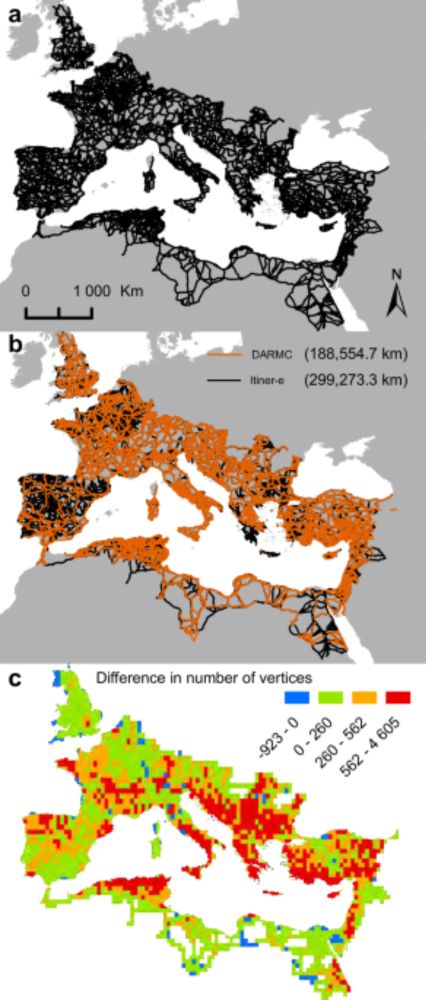
Itiner-e: A high-resolution dataset of roads of the Roman Empire - Scientific Data
Scientific Data - Itiner-e: A high-resolution dataset of roads of the Roman Empire
www.nature.com
November 9, 2025 at 7:37 AM
Trying to figure out my H1 for Mapsemble. Which one is best?
1️⃣ Build Beautiful Maps in Minutes
2️⃣ Map Anything. Save Time. Impress Clients.
3️⃣ From Data to Interactive Map. No Code Needed.
#BuildInPublic #SaaS #GISChat
1️⃣ Build Beautiful Maps in Minutes
2️⃣ Map Anything. Save Time. Impress Clients.
3️⃣ From Data to Interactive Map. No Code Needed.
#BuildInPublic #SaaS #GISChat
November 5, 2025 at 10:15 AM
Trying to figure out my H1 for Mapsemble. Which one is best?
1️⃣ Build Beautiful Maps in Minutes
2️⃣ Map Anything. Save Time. Impress Clients.
3️⃣ From Data to Interactive Map. No Code Needed.
#BuildInPublic #SaaS #GISChat
1️⃣ Build Beautiful Maps in Minutes
2️⃣ Map Anything. Save Time. Impress Clients.
3️⃣ From Data to Interactive Map. No Code Needed.
#BuildInPublic #SaaS #GISChat
November 8, 2025 at 3:21 AM

The CRAN Spatial Task View just got a proper table of contents (thanks to Krzysztof Dyba) -- easier to navigate all those R spatial packages now. 🌍
> https://cran.r-project.org/view=Spatial
#rstats #rspatial #opensource #gischat
> https://cran.r-project.org/view=Spatial
#rstats #rspatial #opensource #gischat


November 5, 2025 at 2:02 PM
The CRAN Spatial Task View just got a proper table of contents (thanks to Krzysztof Dyba) -- easier to navigate all those R spatial packages now. 🌍
> https://cran.r-project.org/view=Spatial
#rstats #rspatial #opensource #gischat
> https://cran.r-project.org/view=Spatial
#rstats #rspatial #opensource #gischat

Hurricane Melissa recently battered Jamaica and the Caribbean. Learn how hot seas led to a record-breaking storm in this new map from #MapsDotCom
ow.ly/vhNg50Xm4jK
#gischat 🌊🧪 #geogchat #geogsky
ow.ly/vhNg50Xm4jK
#gischat 🌊🧪 #geogchat #geogsky

Hurricane Melissa Breaks Records
Hurricane Melissa made landfall in southwestern Jamaica on October 28. It set records along the way.
ow.ly
November 3, 2025 at 8:15 PM
Hurricane Melissa recently battered Jamaica and the Caribbean. Learn how hot seas led to a record-breaking storm in this new map from #MapsDotCom
ow.ly/vhNg50Xm4jK
#gischat 🌊🧪 #geogchat #geogsky
ow.ly/vhNg50Xm4jK
#gischat 🌊🧪 #geogchat #geogsky
#30DayMapChallenge | Day 4: My data (Miniature Globes Edition)
For today’s theme, “My Data,” I created a miniature globe based on Adolf Henze’s Erd-Globus atlas, one of the largest printed globes of the 19th century.
#cartography #handcrafted #mappycrafts #gischat
For today’s theme, “My Data,” I created a miniature globe based on Adolf Henze’s Erd-Globus atlas, one of the largest printed globes of the 19th century.
#cartography #handcrafted #mappycrafts #gischat


November 5, 2025 at 8:14 PM
#30DayMapChallenge | Day 4: My data (Miniature Globes Edition)
For today’s theme, “My Data,” I created a miniature globe based on Adolf Henze’s Erd-Globus atlas, one of the largest printed globes of the 19th century.
#cartography #handcrafted #mappycrafts #gischat
For today’s theme, “My Data,” I created a miniature globe based on Adolf Henze’s Erd-Globus atlas, one of the largest printed globes of the 19th century.
#cartography #handcrafted #mappycrafts #gischat

Thank you for joining our Mappy H🕙ur in September & October! 💙
The recording of the October #MappyHour is on Youtube 🎥 youtu.be/1QcfwhYhdM0
We hope to see you again for this month!
📍 Register: www.eventbrite.com/e/un-mappers...
#OpenStreetMap #opendata #crowdmapping #volunteering #events #gischat
The recording of the October #MappyHour is on Youtube 🎥 youtu.be/1QcfwhYhdM0
We hope to see you again for this month!
📍 Register: www.eventbrite.com/e/un-mappers...
#OpenStreetMap #opendata #crowdmapping #volunteering #events #gischat

November 6, 2025 at 6:10 AM
Thank you for joining our Mappy H🕙ur in September & October! 💙
The recording of the October #MappyHour is on Youtube 🎥 youtu.be/1QcfwhYhdM0
We hope to see you again for this month!
📍 Register: www.eventbrite.com/e/un-mappers...
#OpenStreetMap #opendata #crowdmapping #volunteering #events #gischat
The recording of the October #MappyHour is on Youtube 🎥 youtu.be/1QcfwhYhdM0
We hope to see you again for this month!
📍 Register: www.eventbrite.com/e/un-mappers...
#OpenStreetMap #opendata #crowdmapping #volunteering #events #gischat
#30DayMapChallenge | Day 3: Polygons (Miniature Globes Edition)
For today’s theme, “Polygons,” I created a miniature globe depicting the global extent of ice sheets during the Last Glacial Maximum, approximately 18,000 years ago.
#cartography #handcrafted #mappycraft #gischat
For today’s theme, “Polygons,” I created a miniature globe depicting the global extent of ice sheets during the Last Glacial Maximum, approximately 18,000 years ago.
#cartography #handcrafted #mappycraft #gischat


November 3, 2025 at 7:03 PM
#30DayMapChallenge | Day 3: Polygons (Miniature Globes Edition)
For today’s theme, “Polygons,” I created a miniature globe depicting the global extent of ice sheets during the Last Glacial Maximum, approximately 18,000 years ago.
#cartography #handcrafted #mappycraft #gischat
For today’s theme, “Polygons,” I created a miniature globe depicting the global extent of ice sheets during the Last Glacial Maximum, approximately 18,000 years ago.
#cartography #handcrafted #mappycraft #gischat

GDAL Released: v3.11.5 geoobserver.de/2025/11/05/g... via @GdalOrg @EvenRouault #gdal #ogr #qgis #switch2qgis #fossgis #foss4g #opensource #gistribe #gischat #spatial #geospatial #gis #geo #geoObserver pls RT

November 5, 2025 at 8:21 AM
GDAL Released: v3.11.5 geoobserver.de/2025/11/05/g... via @GdalOrg @EvenRouault #gdal #ogr #qgis #switch2qgis #fossgis #foss4g #opensource #gistribe #gischat #spatial #geospatial #gis #geo #geoObserver pls RT

New paper! Fascinating discussion of Optimizing electric vehicle supply equipment allocation using a range of local and global MCDA methods by Emily Zhou & Junyi Yang, #GISchat doi.org/10.1080/1523...

November 4, 2025 at 3:06 PM
New paper! Fascinating discussion of Optimizing electric vehicle supply equipment allocation using a range of local and global MCDA methods by Emily Zhou & Junyi Yang, #GISchat doi.org/10.1080/1523...
#SLYR: Der esri2qgis Konverter! / The esri2qgis converter! geoobserver.de/2025/11/04/s... via @northroadgeo #qgis #switch2qgis #gistribe #gischat #fossgis #foss4g #OSGeo #spatial #geospatial #opensource #gis #geo #geoObserver pls RT

November 4, 2025 at 11:23 AM
#SLYR: Der esri2qgis Konverter! / The esri2qgis converter! geoobserver.de/2025/11/04/s... via @northroadgeo #qgis #switch2qgis #gistribe #gischat #fossgis #foss4g #OSGeo #spatial #geospatial #opensource #gis #geo #geoObserver pls RT
Did you know that submarine cables on the deep ocean floor literally connect our world?
This map reveals the fragile & mostly unseen infrastructure carrying 99% of Earth's data traffic & providing internet access everywhere.
www.maps.com/submarine-ca...
🧪 🌊 ⚒️ 🌍 🌎 🌏 #gischat @seabed2030.bsky.social
This map reveals the fragile & mostly unseen infrastructure carrying 99% of Earth's data traffic & providing internet access everywhere.
www.maps.com/submarine-ca...
🧪 🌊 ⚒️ 🌍 🌎 🌏 #gischat @seabed2030.bsky.social

The Underwater Cables That Connect the World
Explore the fragile and mostly unseen infrastructure that carries 99% of international data traffic and provides internet access around the world.
www.maps.com
November 1, 2025 at 8:58 PM
Did you know that submarine cables on the deep ocean floor literally connect our world?
This map reveals the fragile & mostly unseen infrastructure carrying 99% of Earth's data traffic & providing internet access everywhere.
www.maps.com/submarine-ca...
🧪 🌊 ⚒️ 🌍 🌎 🌏 #gischat @seabed2030.bsky.social
This map reveals the fragile & mostly unseen infrastructure carrying 99% of Earth's data traffic & providing internet access everywhere.
www.maps.com/submarine-ca...
🧪 🌊 ⚒️ 🌍 🌎 🌏 #gischat @seabed2030.bsky.social

Dude, these mini's are incredible, especially the fact that they're hand crafted. She literally printed out the gores and everything.
#gischat
#gischat
#30DayMapChallenge | Day 2: Lines (Miniature Globes Edition)
For today’s theme, “Lines,” I created a miniature globe of NASA SVS’ Global Sea Surface Currents and Temperature visualization. Look closely to see the mesmerizing ocean eddies!
For today’s theme, “Lines,” I created a miniature globe of NASA SVS’ Global Sea Surface Currents and Temperature visualization. Look closely to see the mesmerizing ocean eddies!


November 3, 2025 at 12:51 AM
Dude, these mini's are incredible, especially the fact that they're hand crafted. She literally printed out the gores and everything.
#gischat
#gischat