Patrick Damian
banner
yvr-patrick.bsky.social
Patrick Damian
@yvr-patrick.bsky.social
Weather enthusiast/guesser
Aspiring broadcast meteorologist.
English/French/Romanian
A Severe Thunderstorm Warning is in effect for #AshtonCreekBC and #KingfisherBC. At 5:27 p.m., a severe thunderstorm capable of producing strong wind, up to nickel size hail and heavy rain was located east of Ashton Creek is moving northeast at 40 km/h. #BCwx #BCStorm #vernonbc
May 30, 2025 at 12:39 AM
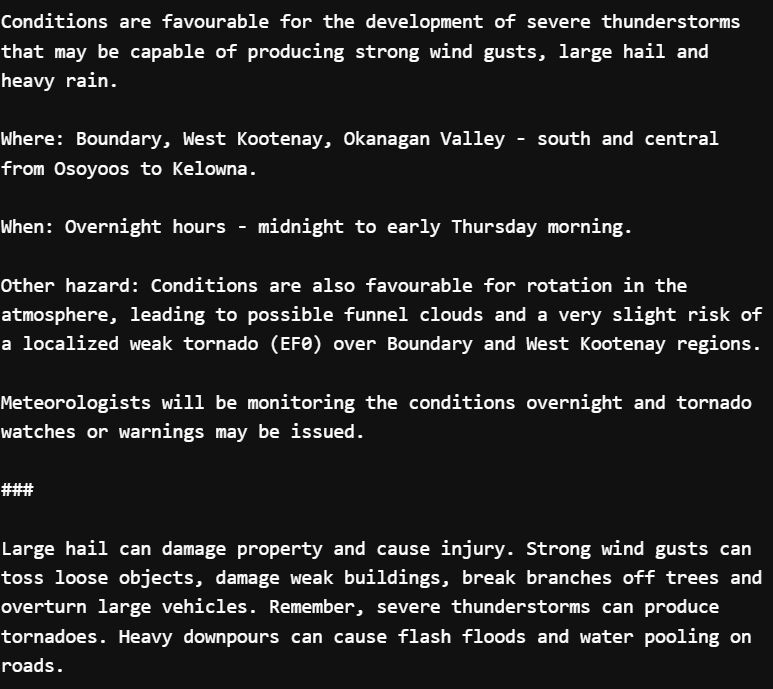
Time for some severe weather in BC! A #SevereThunderstormWatch has been issued the #Okanagan - #BoundaryBC, West Kootenay, Okanagan Valley - south and central from #Osoyoos to #Kelowna.. A TORNADO RISK IS CITED WITH THE WATCH... Stay tuned for further watches and warning! #BCStorm
March 26, 2025 at 11:02 PM
#TSUNAMI WARNING CANCELED... NO THREAT TO #BC. #BCwx
NO THREAT TO #BC YET... Emergency Mgmt BC is currently evaluating the risk for BC. Stay tuned for more info. #Tsunami #BCwx
MAP: Epicenter of 7.0-magnitude earthquake off the coast of Northern California. Tsunami warnings in effect.
December 5, 2024 at 8:00 PM
NO THREAT TO #BC YET... Emergency Mgmt BC is currently evaluating the risk for BC. Stay tuned for more info. #Tsunami #BCwx
MAP: Epicenter of 7.0-magnitude earthquake off the coast of Northern California. Tsunami warnings in effect.
December 5, 2024 at 7:38 PM
Did you receive an #AlertReadyTest today? Consider taking the following survey so @AlertReady can improve their systems: peasi.com/emergency-al...

#AlertReadyTest #AlertReady #TestAlert #Vancouver #BC
November 20, 2024 at 10:04 PM
Reposted by Patrick Damian
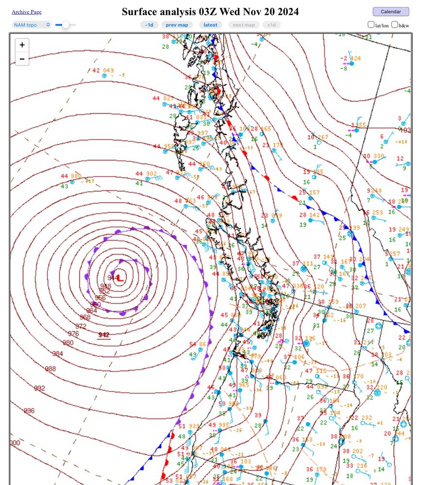
WPC analysis shows the #BombCyclone bottomed out at 942 mb at 03z (19 PT). This ties the record set in October 2021.

#weather #BCstorm #WAwx #ORwx
November 20, 2024 at 7:57 PM
Current look at the #Whistler Snow Ruler over the last 24 hours, and 33 cm of snow was picked up. Snow accumulation began around 8:00 PM last night.

#BCwx #BCSnow #SeaToSky #BCStorm
November 20, 2024 at 5:14 PM
The wind warning that was in effect for #MetroVancouver is now canceled. Wind speeds are no longer expected to meet warning criteria, but SPECIAL WEATHER STATEMENT has been re-issued for the continued risk of strong winds.

#BCStorm #BCwx #Vancouver #BCWind
November 20, 2024 at 7:26 AM
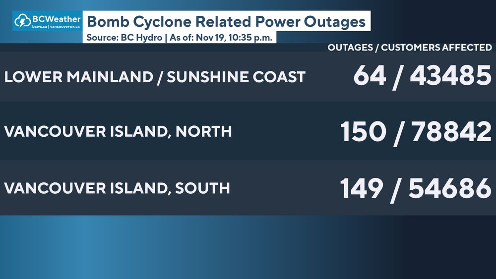
Here is a look at the current number of @bchydro power outages across regions affected by the bomb cyclone, as of 10:35PM.
#Vancouver #VancouverIsland #SunshineCoast #BCStorm #BCwx @paulhaysom.bsky.social @jarmstrongbc.bsky.social
November 20, 2024 at 6:42 AM
Reposted by Patrick Damian
942mb bomb cyclone!! Likely the lowest pressure ever recorded in this area of the Pacific Ocean #wawx
November 20, 2024 at 6:13 AM
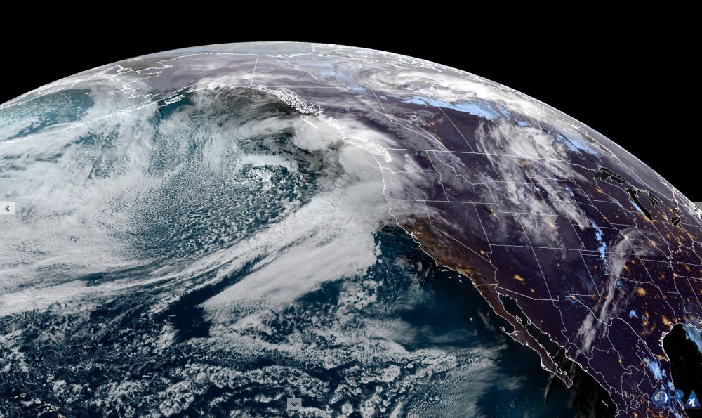
What a beast of a storm... this "super" bomb cyclone dropped 66mb in 24hrs. To be classified as a bomb cyclone, a low has to drop 24mb in 24hrs (1mb/hr). Truly a beauty looking down from satellite.

#bcstorm #wawx #bcwind #bcwx #wawinds #bombcyclone
November 20, 2024 at 6:00 AM
Reposted by Patrick Damian
9 p.m. update from BC Hydro. #bcstorm

For up to date information on outages visit www.bchydro.com/power-outage...
November 20, 2024 at 5:16 AM
Reposted by Patrick Damian
I stitched together the BCHydro outage map to give an idea of the current outages on the south end of VI. #BCstorm
November 20, 2024 at 5:20 AM
Reposted by Patrick Damian
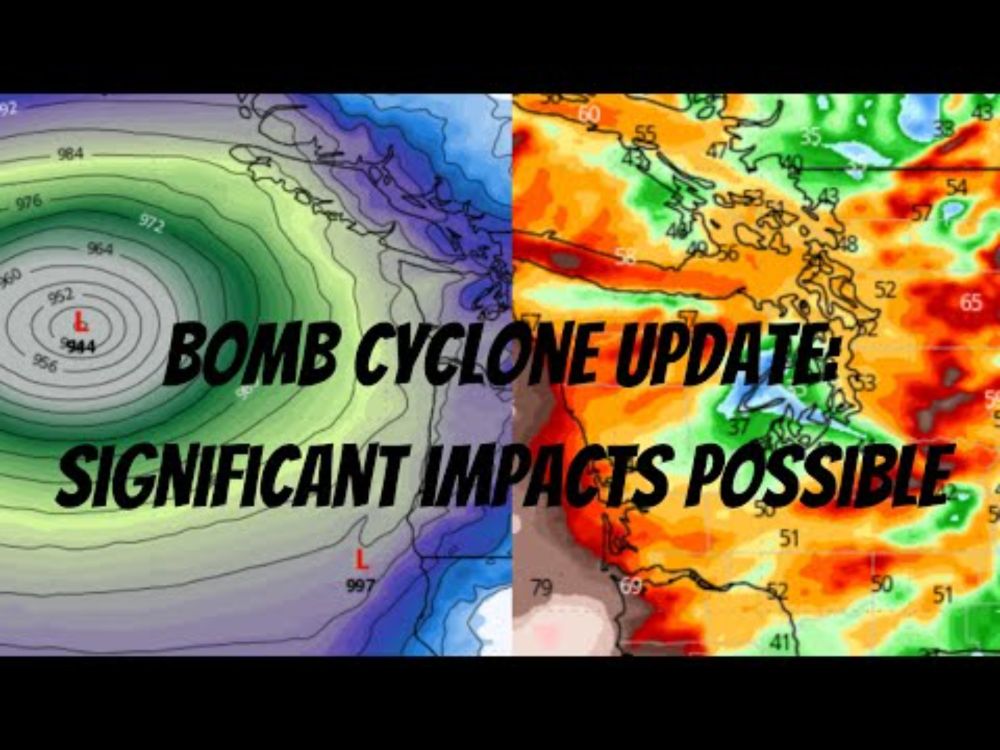
Bomb Cyclone Update: Significant Impacts Possible
#wawx

youtu.be/6t3nJtis4SQ
Bomb Cyclone Update: Significant Impacts Possible
YouTube video by Western Washington Weather
youtu.be
November 17, 2024 at 9:42 PM
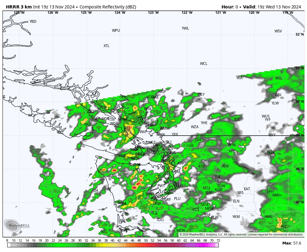
There is minor instability in the atmosphere across #MetroVancouver, that may lead to a few possible rumbles of thunder. WHEN: Tonight through early tomorrow morning.

#BCStorm #BCwx #BCStormWatch #VancouverBC
November 13, 2024 at 9:03 PM
Reposted by Patrick Damian
#SPC issues Day 1 Marginal Convective Risk at Nov 13, 5:28z for SEW link
November 13, 2024 at 5:30 AM
Reposted by Patrick Damian
69 years ago.....
at exactly 10:04pm
Lightning struck the clock tower in Hill Valley
November 13, 2024 at 2:50 AM
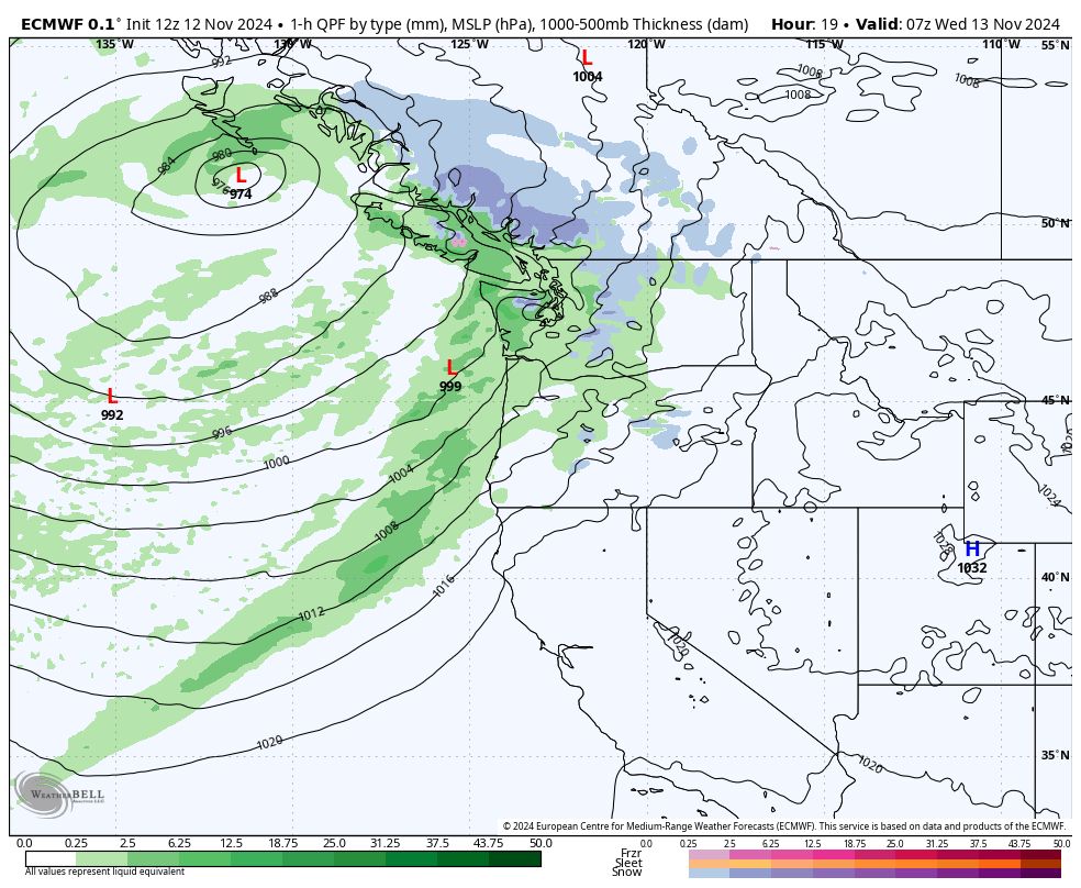
We're still expecting strong winds in and near the #HaroStrait. WHAT: Wind up to 70km/h and gusts up to 90-100 km/h. WHEN: This evening to early Wednesday morning. WHERE: The Haro Strait, near #VictoriaBC, #StraitOfGeorgia and Southern #MetroVancouver.

#BCStorm #BCwx #BCStormWatch #BCwind
November 13, 2024 at 12:29 AM
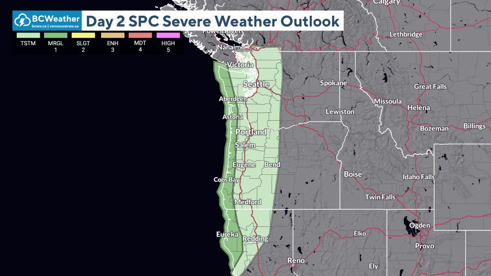
The US Weather Service Storm Prediction Center has issued a Thunderstorm risk for the Washington and Oregon coasts, a thunderstorm is also possible for extreme southwestern coast of Vancouver Island. TOMORROW: A Marginal risk for the same places, with a tstm risk for places more inland... (1)
November 12, 2024 at 7:27 PM
STRONG WINDS EXPECTED TONIGHT
A frontal system going to push through late this evening into tomorrow, that will bring southeasterly winds up to 70km/h, with gusts up to 100km/h expected. Models are expecting the bulk of the winds at the Haro Strait by 11PM and midnight.
#BCStorm #BCWX #BCStormWatch.
November 12, 2024 at 7:10 PM
Reposted by Patrick Damian
WPC issues Day 1 Marginal Risk Excessive Rainfall Outlook at Nov 12, 7:44z for SEW link
November 12, 2024 at 8:16 AM