


Peter Mullinax
@wxmvpete.bsky.social
Meteorologist at NOAA's Weather Predicition Center. Proud father & husband. Northern VA raised, DC sports fan. My thoughts & opinions are my own.
My shot of tonight's aurora from Manchester, MD.

November 12, 2025 at 1:38 AM
My shot of tonight's aurora from Manchester, MD.
Seeing the eye steadily warm/dry out from where it was 4 hours ago (1430Z) to where it is now (1830Z) is another clear sign of #Melissa strengthening. Each HH pass through the eye is showing a warming/drier mid-level layer. And a lower pressure reading each time, of course.


October 26, 2025 at 6:44 PM
Seeing the eye steadily warm/dry out from where it was 4 hours ago (1430Z) to where it is now (1830Z) is another clear sign of #Melissa strengthening. Each HH pass through the eye is showing a warming/drier mid-level layer. And a lower pressure reading each time, of course.
While the track is coming into much better agreement, there remains a good deal of spread regarding when #Melissa makes its NE turn. @burgwx.bsky.social's page shows some members are lagging SW of Jamaica while some are more progressive.

October 26, 2025 at 3:21 PM
While the track is coming into much better agreement, there remains a good deal of spread regarding when #Melissa makes its NE turn. @burgwx.bsky.social's page shows some members are lagging SW of Jamaica while some are more progressive.
To add to the bad news, as the storm drifts west, easterly to SErly flow will blast Jamaica with bands of heavy rainfall well in advance of landfall. Idk what Jamaica's wettest 3 or 4-day observed rainfall is in its recorded history, but have to think #Melissa has a good chance to break it.
October 26, 2025 at 3:08 PM
To add to the bad news, as the storm drifts west, easterly to SErly flow will blast Jamaica with bands of heavy rainfall well in advance of landfall. Idk what Jamaica's wettest 3 or 4-day observed rainfall is in its recorded history, but have to think #Melissa has a good chance to break it.
06Z HAFS-B pressure forecast was closer to what HHs were observing earlier today. It shows another period of RI starting sometime tonight and into Monday morning. Given #Melissa has another 48 hrs over the Caribbean, it unfortunately still has time to strengthen prior to landfall.
October 26, 2025 at 3:08 PM
06Z HAFS-B pressure forecast was closer to what HHs were observing earlier today. It shows another period of RI starting sometime tonight and into Monday morning. Given #Melissa has another 48 hrs over the Caribbean, it unfortunately still has time to strengthen prior to landfall.

WPC has started Key Messages for the coastal storm that is set to bring a myriad of impacts to the East Coast this weekend. These will be updated under WPC's Top Stories section on WPC's homepage each day through the upcoming weekend.

October 8, 2025 at 6:24 PM
WPC has started Key Messages for the coastal storm that is set to bring a myriad of impacts to the East Coast this weekend. These will be updated under WPC's Top Stories section on WPC's homepage each day through the upcoming weekend.
Heavy rain is coming to the Southwest over the next 7 days thanks to Priscilla late week & the trailing East Pacific disturbance this weekend. Flooding is going to be a problem the second half of the week in heavily impacted areas, along complex terrain, & over burn scars.

October 8, 2025 at 11:49 AM
Heavy rain is coming to the Southwest over the next 7 days thanks to Priscilla late week & the trailing East Pacific disturbance this weekend. Flooding is going to be a problem the second half of the week in heavily impacted areas, along complex terrain, & over burn scars.
My initial reaction: "oh man, if only this were January!"
Thinks more about how recent years have gone: "it would find a way to be 33 and rain, wouldn't it."
Thinks more about how recent years have gone: "it would find a way to be 33 and rain, wouldn't it."

October 7, 2025 at 5:59 PM
My initial reaction: "oh man, if only this were January!"
Thinks more about how recent years have gone: "it would find a way to be 33 and rain, wouldn't it."
Thinks more about how recent years have gone: "it would find a way to be 33 and rain, wouldn't it."
There is lightning inside of 5 miles. This is a no-brainer delay for little league sports, middle school and high school, college, and pro sports.

September 5, 2025 at 2:40 AM
There is lightning inside of 5 miles. This is a no-brainer delay for little league sports, middle school and high school, college, and pro sports.
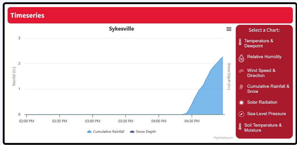
Between 4:28 PMand 4:58 PM (30 minutes), the Sykesville, MD newly minted mesonet station recorded 2" in 30 minutes. mesonet.umd.edu/station?stid...
July 31, 2025 at 9:02 PM
Between 4:28 PMand 4:58 PM (30 minutes), the Sykesville, MD newly minted mesonet station recorded 2" in 30 minutes. mesonet.umd.edu/station?stid...
Yep, don't like that at all.

July 31, 2025 at 8:52 PM
Yep, don't like that at all.
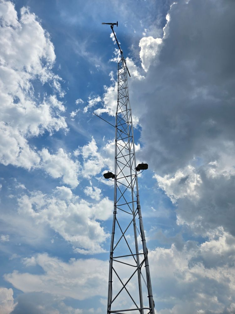
I visited it today! Should be up and running!
July 31, 2025 at 8:44 PM
I visited it today! Should be up and running!
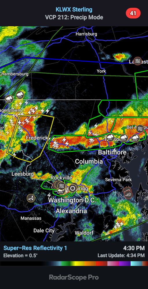
Curious to see how well this line of storms along and north of I-70 maintains itself as storms approach from Frederick County.
July 31, 2025 at 8:35 PM
Curious to see how well this line of storms along and north of I-70 maintains itself as storms approach from Frederick County.
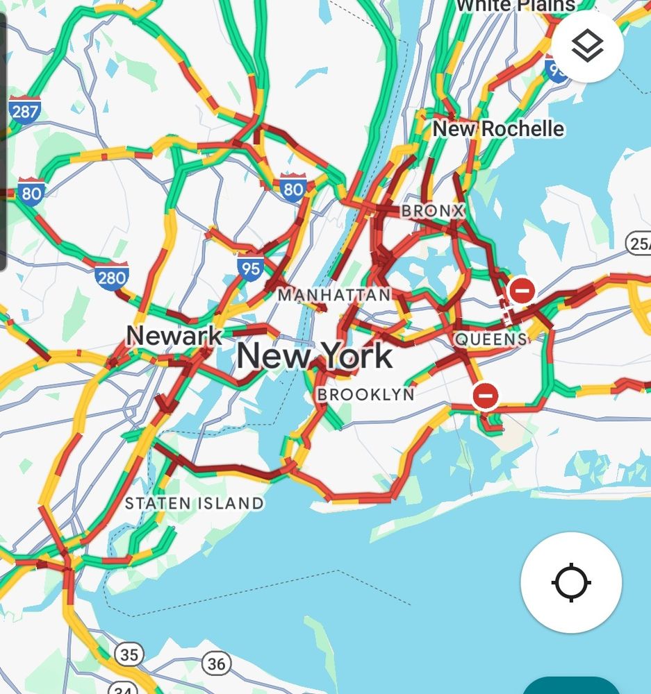
Rough go traffic-wise in NYC at the moment.
July 31, 2025 at 7:42 PM
Rough go traffic-wise in NYC at the moment.
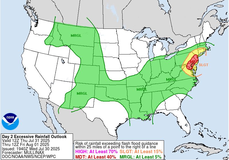
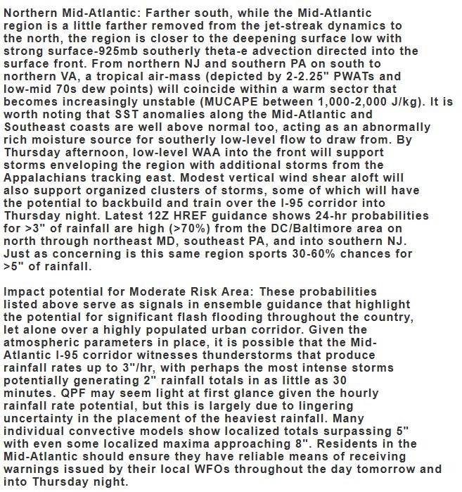
Here's the latest WPC Excessive Rainfall Outlook & my section of the discussion highlighting the region with the Moderate Risk. It's important to note there remains uncertainty on model guidance regarding the placement of the heaviest rainfall. But individual CAMs show as much as 5-8" of rain.
July 30, 2025 at 8:06 PM
Here's the latest WPC Excessive Rainfall Outlook & my section of the discussion highlighting the region with the Moderate Risk. It's important to note there remains uncertainty on model guidance regarding the placement of the heaviest rainfall. But individual CAMs show as much as 5-8" of rain.
Good evening, Milwaukee!

July 18, 2025 at 2:16 AM
Good evening, Milwaukee!
Those in Texas should have phones and NOAA Weather radio at the ready for what is looking like, unfortunately, another dangerous night of flash flooding. www.wpc.ncep.noaa.gov/metwatch/met...
July 13, 2025 at 5:41 AM
Those in Texas should have phones and NOAA Weather radio at the ready for what is looking like, unfortunately, another dangerous night of flash flooding. www.wpc.ncep.noaa.gov/metwatch/met...
My latest MPD for #Chantal mentions that rainfall rates should steadily decrease tonight, but the storm's generally slow progression & still highly efficient rainfall rates will keep the significant flash flood threat going through this evening. www.wpc.ncep.noaa.gov/metwatch/met...
July 7, 2025 at 12:11 AM
My latest MPD for #Chantal mentions that rainfall rates should steadily decrease tonight, but the storm's generally slow progression & still highly efficient rainfall rates will keep the significant flash flood threat going through this evening. www.wpc.ncep.noaa.gov/metwatch/met...
Additional flash flooding in south-central TX possible this afternoon: www.wpc.ncep.noaa.gov/metwatch/met...
July 6, 2025 at 8:20 PM
Additional flash flooding in south-central TX possible this afternoon: www.wpc.ncep.noaa.gov/metwatch/met...
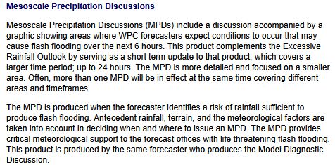
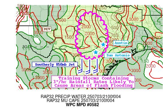
These are not warnings, rather outlooks that discuss the potential for excessive rainfall rates that could or likely will cause flash flooding. Here's a description of the product. I did the first MPD highlighted in this post (582). Other forecasters that night and the next day issued the others.
July 6, 2025 at 1:17 AM
These are not warnings, rather outlooks that discuss the potential for excessive rainfall rates that could or likely will cause flash flooding. Here's a description of the product. I did the first MPD highlighted in this post (582). Other forecasters that night and the next day issued the others.
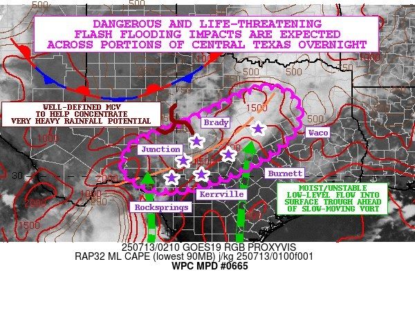
There is concern for the ongoing storms over southern Burnet county to build west into other hard hit counties. Seeing that now on radar in southern Llano county, with HRRR & RRFS guidance showing this potential well for at least a couple hours. www.wpc.ncep.noaa.gov/metwatch/met...
July 5, 2025 at 7:48 PM
There is concern for the ongoing storms over southern Burnet county to build west into other hard hit counties. Seeing that now on radar in southern Llano county, with HRRR & RRFS guidance showing this potential well for at least a couple hours. www.wpc.ncep.noaa.gov/metwatch/met...
Alarm bells really went off at 00Z Del Rio, TX sounding. The RAOB was closer to the mid-level circulation center, but incredibly the 2.34" PWAT wasn't close to the highest core of PWATs over the Hill Country. Veering low-mid level winds, high freezing level, modest CAPE, saturated profile...all bad.

July 5, 2025 at 12:35 AM
Alarm bells really went off at 00Z Del Rio, TX sounding. The RAOB was closer to the mid-level circulation center, but incredibly the 2.34" PWAT wasn't close to the highest core of PWATs over the Hill Country. Veering low-mid level winds, high freezing level, modest CAPE, saturated profile...all bad.
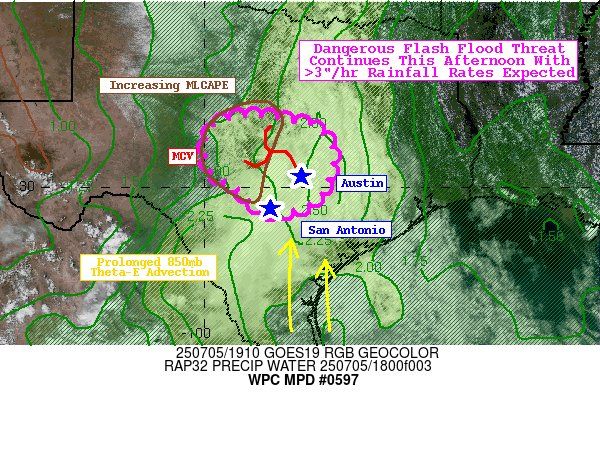
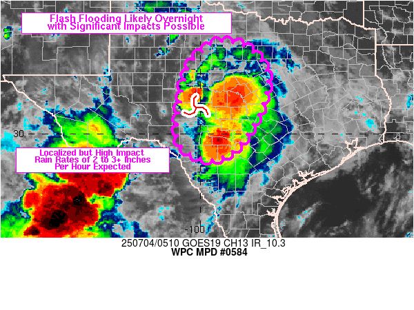
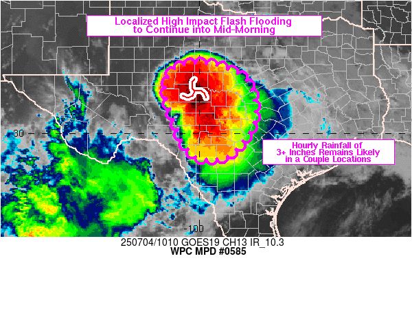
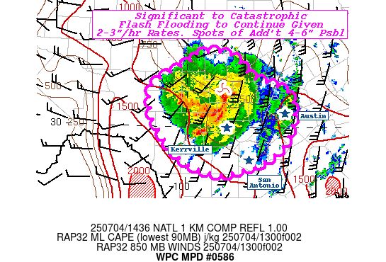
WPC issued as many as six MPDs for the deadly flash flooding in the TX Hill Country starting yesterday evening and lasting through much of today. The first MPD generally set the stage for what was to come, while the next three shown were as the event unfolded.
July 5, 2025 at 12:03 AM
WPC issued as many as six MPDs for the deadly flash flooding in the TX Hill Country starting yesterday evening and lasting through much of today. The first MPD generally set the stage for what was to come, while the next three shown were as the event unfolded.
I just sent out this MPD for the Mid-Atlantic. Several modes for thunderstorm initiation this afternoon and evening within an environment with modest instability & moisture content. Flash flooding is possible. www.wpc.ncep.noaa.gov/metwatch/met...

June 26, 2025 at 7:52 PM
I just sent out this MPD for the Mid-Atlantic. Several modes for thunderstorm initiation this afternoon and evening within an environment with modest instability & moisture content. Flash flooding is possible. www.wpc.ncep.noaa.gov/metwatch/met...