


Dan Rupp
@wxdan24.bsky.social
Meteorologist/Cloud Wizard @AEM-EarthNetworks & WeatherBug |📍Washington, DC 🏛️ | Penn State Alum | Instagram: WxDan24 | I stare at clouds and try to predict their next mood
Reposted by Dan Rupp

Unbelievable footage from NOAA’s Hurricane Hunters inside the eye of Hurricane Erin.
Simply incredible.
Simply incredible.
August 16, 2025 at 9:22 PM
Unbelievable footage from NOAA’s Hurricane Hunters inside the eye of Hurricane Erin.
Simply incredible.
Simply incredible.
Reposted by Dan Rupp

Rapid attribution studies are often incomplete. Study doesn't account for the broadening of the dry season into mid-winter, which leads to increasing likeliness of overlap with offshore wind season (and the probably of encountering the dry hot 100 mph Santa Ana winds that played such a key role).

New UCLA rapid attribution study: “Climate change may be linked to roughly a quarter of the extreme fuel moisture deficit when the fires began.
The fires would still have been extreme without climate change, but probably somewhat smaller and less intense.”
sustainablela.ucla.edu/2025lawildfi...
The fires would still have been extreme without climate change, but probably somewhat smaller and less intense.”
sustainablela.ucla.edu/2025lawildfi...
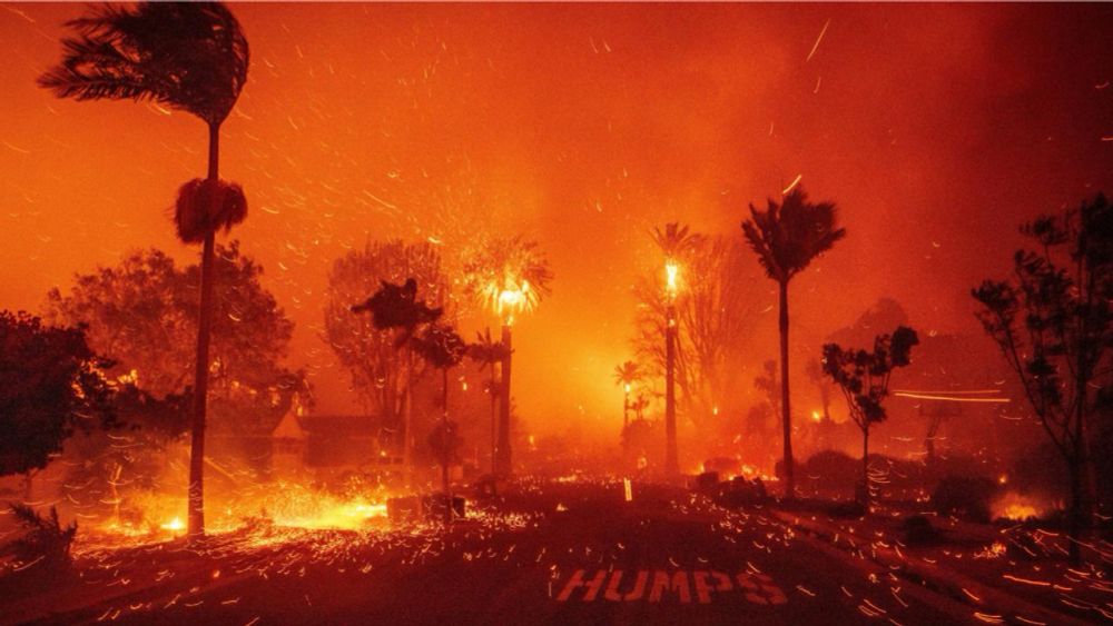
Climate Change A Factor In Unprecedented LA Fires
sustainablela.ucla.edu
January 18, 2025 at 4:13 PM
Rapid attribution studies are often incomplete. Study doesn't account for the broadening of the dry season into mid-winter, which leads to increasing likeliness of overlap with offshore wind season (and the probably of encountering the dry hot 100 mph Santa Ana winds that played such a key role).
Reposted by Dan Rupp

November 29th was the snowiest day on record for Erie. ☃#PAwx

December 1, 2024 at 3:05 PM
November 29th was the snowiest day on record for Erie. ☃#PAwx
Reposted by Dan Rupp

Looks like a nice setup across New Mexico today. Later this afternoon, I expect a couple of supercells across south-central and southeastern New Mexico and a modest tornado chance. I am not able to get out there myself today so here are my thoughts on the forecast: (thread!)


October 19, 2024 at 3:36 PM
Looks like a nice setup across New Mexico today. Later this afternoon, I expect a couple of supercells across south-central and southeastern New Mexico and a modest tornado chance. I am not able to get out there myself today so here are my thoughts on the forecast: (thread!)
Thanks to a cut-off upper level low sitting over the four corner states, we have quite the light show over New Mexico today. Our Earth Networks Total Lightning Network (ENTLN) picking up a handful of strikes.

October 19, 2024 at 3:33 PM
Thanks to a cut-off upper level low sitting over the four corner states, we have quite the light show over New Mexico today. Our Earth Networks Total Lightning Network (ENTLN) picking up a handful of strikes.
Reposted by Dan Rupp

Impressive visualization of power outages caused by Hurricane Helene, and the amazing restoration work by linemen.
Max customers out at one time: 4.79 million
Total customers Affected: Over 7.4 million
Max customers out at one time: 4.79 million
Total customers Affected: Over 7.4 million
October 17, 2024 at 8:52 PM
Impressive visualization of power outages caused by Hurricane Helene, and the amazing restoration work by linemen.
Max customers out at one time: 4.79 million
Total customers Affected: Over 7.4 million
Max customers out at one time: 4.79 million
Total customers Affected: Over 7.4 million
That is one beefy high pressure system over the East this mid-October. Any tropical activity that wants to form in the Caribbean would steer clear of mainland U.S. and take a westward track. Enjoy the beautiful fall days ahead. 🍂

October 18, 2024 at 5:40 PM
That is one beefy high pressure system over the East this mid-October. Any tropical activity that wants to form in the Caribbean would steer clear of mainland U.S. and take a westward track. Enjoy the beautiful fall days ahead. 🍂
Reposted by Dan Rupp

Comparing accumulated cyclone energy (ACE) during the typical peak 30-day period, to the total ACE excluding that period, for every Atlantic hurricane season on record.
2024, a clear outlier, had one of the quietest peak seasons ever, while still managing the 4th highest "off-peak" ACE on record.
2024, a clear outlier, had one of the quietest peak seasons ever, while still managing the 4th highest "off-peak" ACE on record.

October 18, 2024 at 5:15 PM
Comparing accumulated cyclone energy (ACE) during the typical peak 30-day period, to the total ACE excluding that period, for every Atlantic hurricane season on record.
2024, a clear outlier, had one of the quietest peak seasons ever, while still managing the 4th highest "off-peak" ACE on record.
2024, a clear outlier, had one of the quietest peak seasons ever, while still managing the 4th highest "off-peak" ACE on record.
Reposted by Dan Rupp

Uhh, just waiting for sea ice to begin expanding across the Canadian #Arctic Archipelago... 🥴
Data from nsidc.org/data/seaice_...
Data from nsidc.org/data/seaice_...

October 18, 2024 at 1:28 PM
Uhh, just waiting for sea ice to begin expanding across the Canadian #Arctic Archipelago... 🥴
Data from nsidc.org/data/seaice_...
Data from nsidc.org/data/seaice_...
Reposted by Dan Rupp
Posted by NWS Sioux Falls...this is a terribly dry map.
Huge precipitation deficits since September 1. No surprise that drought is expanding and worsening.
Huge precipitation deficits since September 1. No surprise that drought is expanding and worsening.

October 18, 2024 at 1:53 PM
Posted by NWS Sioux Falls...this is a terribly dry map.
Huge precipitation deficits since September 1. No surprise that drought is expanding and worsening.
Huge precipitation deficits since September 1. No surprise that drought is expanding and worsening.
Reposted by Dan Rupp
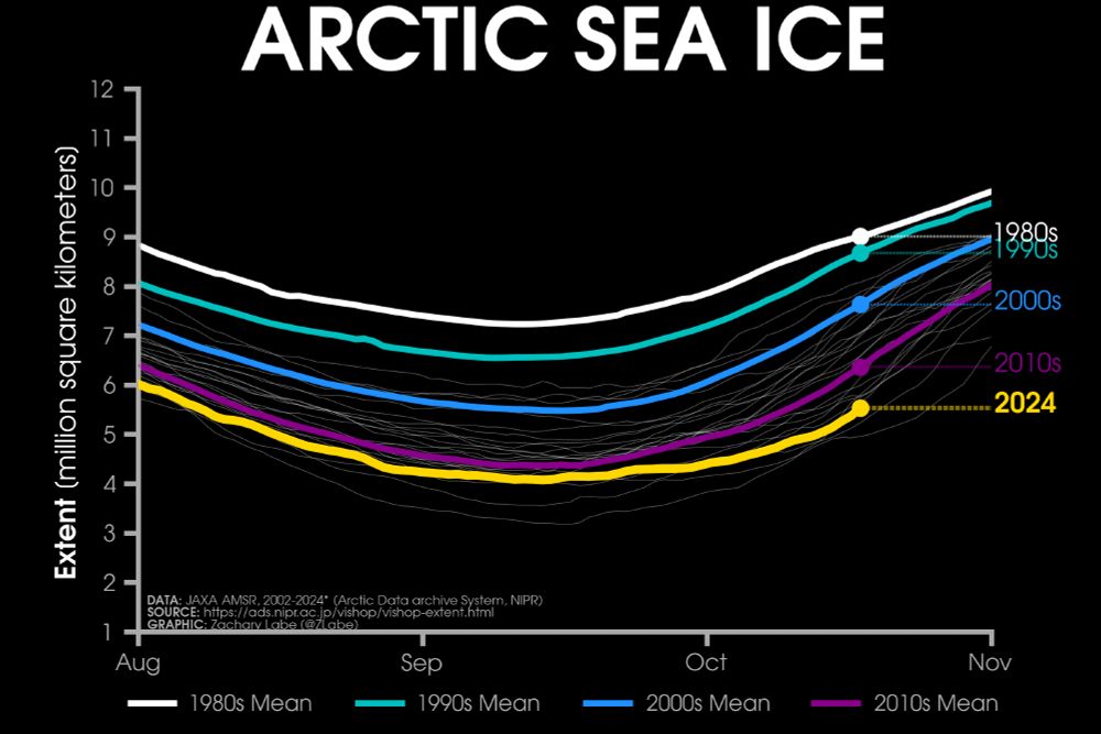
Friday ice update - #Arctic sea ice extent is currently the 3rd lowest on record (JAXA data)
• about 830,000 km² below the 2010s mean
• about 2,090,000 km² below the 2000s mean
• about 3,140,000 km² below the 1990s mean
• about 3,470,000 km² below the 1980s mean
Plots zacklabe.com/arctic-sea-i...
• about 830,000 km² below the 2010s mean
• about 2,090,000 km² below the 2000s mean
• about 3,140,000 km² below the 1990s mean
• about 3,470,000 km² below the 1980s mean
Plots zacklabe.com/arctic-sea-i...
October 18, 2024 at 3:11 PM
Friday ice update - #Arctic sea ice extent is currently the 3rd lowest on record (JAXA data)
• about 830,000 km² below the 2010s mean
• about 2,090,000 km² below the 2000s mean
• about 3,140,000 km² below the 1990s mean
• about 3,470,000 km² below the 1980s mean
Plots zacklabe.com/arctic-sea-i...
• about 830,000 km² below the 2010s mean
• about 2,090,000 km² below the 2000s mean
• about 3,140,000 km² below the 1990s mean
• about 3,470,000 km² below the 1980s mean
Plots zacklabe.com/arctic-sea-i...
Reposted by Dan Rupp


October 16, 2024 at 12:48 AM