


Michael Barnes
@weathermanbarnes.bsky.social
Meteorologist and Research Fellow at @21stcenturyweather.bsky.social,
@monashuniversity.bsky.social | www.weathermanbarnes.com
@monashuniversity.bsky.social | www.weathermanbarnes.com
Ensemble mean column added :)

March 10, 2025 at 4:29 AM
Ensemble mean column added :)
Spectacular RADAR imagery of the eye of TC Zelia as it makes its way onshore to the east of Port Hedland, Western Australia.
Credit: Australian Bureau of Meteorology
Credit: Australian Bureau of Meteorology
February 14, 2025 at 3:00 AM
Spectacular RADAR imagery of the eye of TC Zelia as it makes its way onshore to the east of Port Hedland, Western Australia.
Credit: Australian Bureau of Meteorology
Credit: Australian Bureau of Meteorology
A potentially extreme heatwave on cards for Victoria to start off Feruary with some simuations indicating stretches of 40C for Melbourne. ECMWF eIFS Maximum Temperature forecasts for all 50 membes for Melbourne below.

January 28, 2025 at 1:22 AM
A potentially extreme heatwave on cards for Victoria to start off Feruary with some simuations indicating stretches of 40C for Melbourne. ECMWF eIFS Maximum Temperature forecasts for all 50 membes for Melbourne below.
Another bout of explosive cyclogenesis over the North Atlantic with "Storm Eowyn" bearing down on the UK, bringing with it strong winds and heavy rainfall. Here is ECMWF's few of the system.
January 23, 2025 at 11:25 PM
Another bout of explosive cyclogenesis over the North Atlantic with "Storm Eowyn" bearing down on the UK, bringing with it strong winds and heavy rainfall. Here is ECMWF's few of the system.
Deep westeries and rainy. A hard, technical criteria is maybe not always the best....


January 23, 2025 at 4:02 AM
Deep westeries and rainy. A hard, technical criteria is maybe not always the best....
The remnants of TC Sean that have transitioned into the extratropics, presumably bring with it additional moisture and diabatic heating into the mid-latitude waveguide. This process promotes anticyclogenesis in upper troposphere which in turn promotes adiabatic descent and heat into VIC next week
January 22, 2025 at 11:09 PM
The remnants of TC Sean that have transitioned into the extratropics, presumably bring with it additional moisture and diabatic heating into the mid-latitude waveguide. This process promotes anticyclogenesis in upper troposphere which in turn promotes adiabatic descent and heat into VIC next week
TC Sean will also play a hand in hot weather over the SE early next week, with temperatures expected to reach into the 40s in Victoria on Monday. Below is the ECMWF eIFS forecast for various parts of the state.

January 22, 2025 at 10:59 PM
TC Sean will also play a hand in hot weather over the SE early next week, with temperatures expected to reach into the 40s in Victoria on Monday. Below is the ECMWF eIFS forecast for various parts of the state.
Secondly and I think possibly most importantly, the outflow from TC Sean promotes ridging in the upper troposphere, pushing back the jet stream to the south of WA, similar to the effect studied by @tessjparker.bsky.social in her work on SE Aus heatwaves (doi.org/10.1002/2013...)
January 22, 2025 at 10:57 PM
Secondly and I think possibly most importantly, the outflow from TC Sean promotes ridging in the upper troposphere, pushing back the jet stream to the south of WA, similar to the effect studied by @tessjparker.bsky.social in her work on SE Aus heatwaves (doi.org/10.1002/2013...)
First, TC Sean tightens up the pressure gradient, promoting and strengthening easterlies and adiabatic descent towards the coast. Some of the below trajectories into Perth highlight this effect.
January 22, 2025 at 10:51 PM
First, TC Sean tightens up the pressure gradient, promoting and strengthening easterlies and adiabatic descent towards the coast. Some of the below trajectories into Perth highlight this effect.
Southern WA experienced have experienced extremely hot temperatures, with Geraldton nearing the 50C mark. TC Sean has a part to play in this.

January 22, 2025 at 10:49 PM
Southern WA experienced have experienced extremely hot temperatures, with Geraldton nearing the 50C mark. TC Sean has a part to play in this.
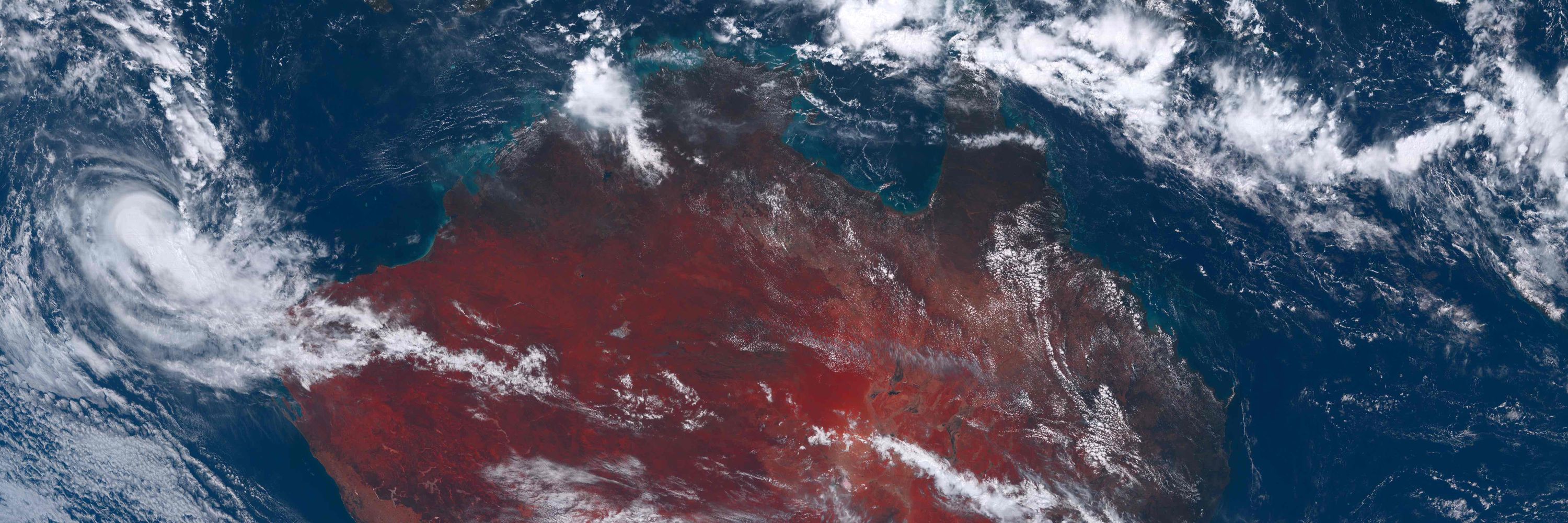
Tropical vortices play a larger role in the weather over the Australian continent than strong wind and heavy rain. Despite only a glancing impact on rainfall over northern Western Australia, Tropical Cyclone Sean has and will have an impact on many region this week, but not in the way you may expect
January 22, 2025 at 10:45 PM
Tropical vortices play a larger role in the weather over the Australian continent than strong wind and heavy rain. Despite only a glancing impact on rainfall over northern Western Australia, Tropical Cyclone Sean has and will have an impact on many region this week, but not in the way you may expect
Weak tropical vortices can pack a punch!! 100s of mm of rain falling over the QLD coast today. Rain will continue tomorrow and cease by Sunday as the vortex is moved offshore.


December 20, 2024 at 11:00 AM
Weak tropical vortices can pack a punch!! 100s of mm of rain falling over the QLD coast today. Rain will continue tomorrow and cease by Sunday as the vortex is moved offshore.
The impact of a summertime front - a 20-degree Celsius drop in just a matter of hours here in Melbourne!

December 16, 2024 at 10:56 PM
The impact of a summertime front - a 20-degree Celsius drop in just a matter of hours here in Melbourne!
A beautiful example of anticyclonic Rossby wave breaking that will bring heat to the southeast tomorrow. The cyclonic feature (cut-off) over QLD also brought heavy rainfall that region yesterday.

December 15, 2024 at 7:41 AM
A beautiful example of anticyclonic Rossby wave breaking that will bring heat to the southeast tomorrow. The cyclonic feature (cut-off) over QLD also brought heavy rainfall that region yesterday.
We are certainly on track for a December Melbourne 40C day

December 12, 2024 at 10:53 PM
We are certainly on track for a December Melbourne 40C day
Hot weather is possible for early next week over SE Australia. Still uncertainty however with only a few members of the ECMWF ensemble (including the deterministic forecast) reaching into the 40s for Melbourne. Expecting a lot of bouncing around for the next few days. A forecast to watch!

December 10, 2024 at 9:55 AM
Hot weather is possible for early next week over SE Australia. Still uncertainty however with only a few members of the ECMWF ensemble (including the deterministic forecast) reaching into the 40s for Melbourne. Expecting a lot of bouncing around for the next few days. A forecast to watch!
Fizzled unfortunately (or fortunately). We have this depression off the coast which should provide some good rain for the northwest and small (and seemingly diminishing) chances of another depression/TC next week.

December 10, 2024 at 3:50 AM
Fizzled unfortunately (or fortunately). We have this depression off the coast which should provide some good rain for the northwest and small (and seemingly diminishing) chances of another depression/TC next week.
Coincident with a very active tropical NW Australia - notable!

December 10, 2024 at 1:29 AM
Coincident with a very active tropical NW Australia - notable!
Potential for Australia's first landfalling tropical cyclone of the 2024/2025 season next week over the northern WA coast. Models showing remarkable consistency in the development of a tropical vortex in the area given it is 7-10 days out. An interesting forecast to follow over the coming few days!

December 4, 2024 at 2:47 AM
Potential for Australia's first landfalling tropical cyclone of the 2024/2025 season next week over the northern WA coast. Models showing remarkable consistency in the development of a tropical vortex in the area given it is 7-10 days out. An interesting forecast to follow over the coming few days!
Spectacular springtime cut-off low affecting the eastern parts of Australia today, with its associated front and warm conveyor belt bringing widespread showers to many.
Image source: Bureau of Meteorology
Image source: Bureau of Meteorology

November 29, 2024 at 10:29 PM
Spectacular springtime cut-off low affecting the eastern parts of Australia today, with its associated front and warm conveyor belt bringing widespread showers to many.
Image source: Bureau of Meteorology
Image source: Bureau of Meteorology
The details of a forecast matter greatly to the detail of the impact. Despite fairly certain synoptics for late this week over Australia, precipitation forecasts can range by over 100mm depending on your location in eastern Australia. Deterministic forecasts are not enough to assess risk.

November 25, 2024 at 9:46 AM
The details of a forecast matter greatly to the detail of the impact. Despite fairly certain synoptics for late this week over Australia, precipitation forecasts can range by over 100mm depending on your location in eastern Australia. Deterministic forecasts are not enough to assess risk.
Incredible satellite imagery to start your Wednesday!! Explosive cyclogenesis off the west coast of North America
Credit: Colorado State (rammb-slider.cira.colostate.edu)
Credit: Colorado State (rammb-slider.cira.colostate.edu)

November 19, 2024 at 11:18 PM
Incredible satellite imagery to start your Wednesday!! Explosive cyclogenesis off the west coast of North America
Credit: Colorado State (rammb-slider.cira.colostate.edu)
Credit: Colorado State (rammb-slider.cira.colostate.edu)
Remarkable explosive cyclogenesis off of the west coast of North America in the forecast, with a predicted drop of over 50hPa in just 12 hours!!! I wonder if this is a record intensification for an extratropical low?
November 19, 2024 at 12:54 AM
Remarkable explosive cyclogenesis off of the west coast of North America in the forecast, with a predicted drop of over 50hPa in just 12 hours!!! I wonder if this is a record intensification for an extratropical low?