


Taylor Trogdon
@ttrogdon.bsky.social
CIRA Deputy Associate Director - Global Systems Laboratory - Boulder, CO
Here for meaningful and intentional conversations about how to move the weather enterprise forward.
Here for meaningful and intentional conversations about how to move the weather enterprise forward.
Sometimes the best events are the unexpected ones. The green embedded within the reds/pinks was the best I’ve ever seen.
From Lafayette, CO.
From Lafayette, CO.

November 12, 2025 at 3:56 AM
Sometimes the best events are the unexpected ones. The green embedded within the reds/pinks was the best I’ve ever seen.
From Lafayette, CO.
From Lafayette, CO.
Out of all the stats that will be in history books from Melissa, this is the most astounding to me.
GLM data was recording a peak flash rate of 700 strikes per minute — nearly 12 per second — as it made landfall on Jamaica. That’s rewriting our understanding flash density in tropical cyclones.
GLM data was recording a peak flash rate of 700 strikes per minute — nearly 12 per second — as it made landfall on Jamaica. That’s rewriting our understanding flash density in tropical cyclones.

November 6, 2025 at 11:47 PM
Out of all the stats that will be in history books from Melissa, this is the most astounding to me.
GLM data was recording a peak flash rate of 700 strikes per minute — nearly 12 per second — as it made landfall on Jamaica. That’s rewriting our understanding flash density in tropical cyclones.
GLM data was recording a peak flash rate of 700 strikes per minute — nearly 12 per second — as it made landfall on Jamaica. That’s rewriting our understanding flash density in tropical cyclones.


A beautiful loop illustrating forward-propagation versus supercells moving right against the mean wind and ultimately the difference in net motion.

June 21, 2025 at 3:34 PM
A beautiful loop illustrating forward-propagation versus supercells moving right against the mean wind and ultimately the difference in net motion.
Given the storm environment, this is an almost guaranteed derecho across the northern plains. Eventual absorption of the pair of supercells ahead of the line will occur over the next hour w/ an exceptional damaging wind threat continuing w/ episodic tornadoes through tonight as the bow echo matures.

June 21, 2025 at 3:38 AM
Given the storm environment, this is an almost guaranteed derecho across the northern plains. Eventual absorption of the pair of supercells ahead of the line will occur over the next hour w/ an exceptional damaging wind threat continuing w/ episodic tornadoes through tonight as the bow echo matures.
Central Oklahoma wildfire outbreak.

March 14, 2025 at 9:55 PM
Central Oklahoma wildfire outbreak.
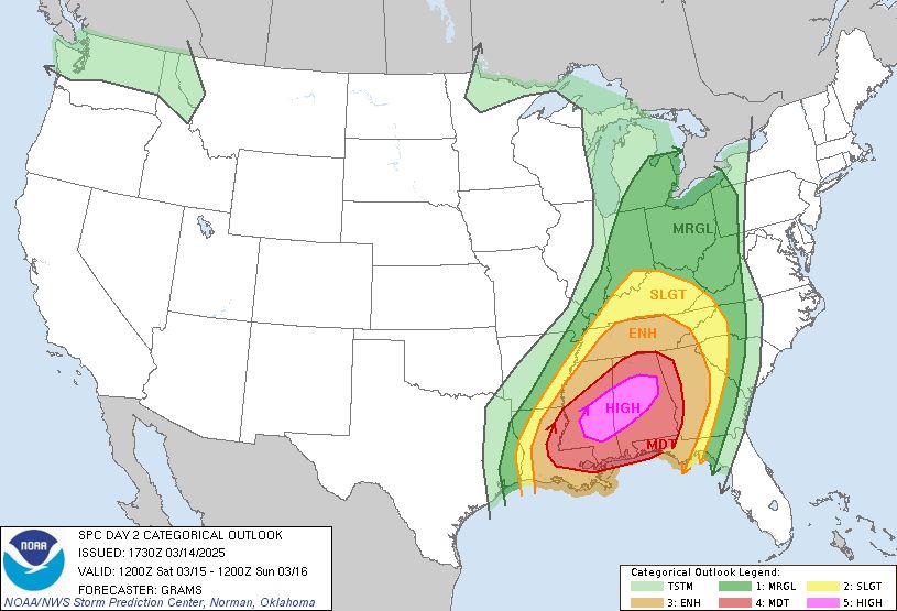
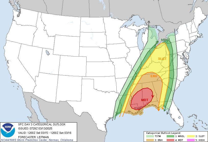
Today and tomorrow have the potential to be one of the worst consecutive day outbreaks in the US in a long time.
Day 2 High Risk issued for Saturday.
While you may check the weather often, friends or family may not. Reach out to them. You could be the voice they need to hear.
Day 2 High Risk issued for Saturday.
While you may check the weather often, friends or family may not. Reach out to them. You could be the voice they need to hear.

March 14, 2025 at 5:47 PM
Today and tomorrow have the potential to be one of the worst consecutive day outbreaks in the US in a long time.
Day 2 High Risk issued for Saturday.
While you may check the weather often, friends or family may not. Reach out to them. You could be the voice they need to hear.
Day 2 High Risk issued for Saturday.
While you may check the weather often, friends or family may not. Reach out to them. You could be the voice they need to hear.
The importance of the NWS will be on full display through Saturday with multiple outbreaks of severe thunderstorms, including damaging, long-track tornadoes. In addition to the severe weather threat, a wildfire outbreak is also possible on Friday fueled by very strong winds and dry fuels.


March 13, 2025 at 12:31 PM
The importance of the NWS will be on full display through Saturday with multiple outbreaks of severe thunderstorms, including damaging, long-track tornadoes. In addition to the severe weather threat, a wildfire outbreak is also possible on Friday fueled by very strong winds and dry fuels.
Look at the density!

February 18, 2025 at 6:58 PM
Look at the density!
This morning was the most significant (and coolest) hoar frost event I’ve seen in Colorado and perhaps anywhere outside of the mountains. Absolutely beautiful.

February 18, 2025 at 6:12 PM
This morning was the most significant (and coolest) hoar frost event I’ve seen in Colorado and perhaps anywhere outside of the mountains. Absolutely beautiful.
We officially have thundersnow near the Gulf Coast - what an incredible event.

January 21, 2025 at 3:25 PM
We officially have thundersnow near the Gulf Coast - what an incredible event.
An extreme event is setting for the greater New Orleans area. The maximum 3-day snowfall I can find is 2.7" which occurred on New Years eve in 1963. The official forecast calls for 3-6" in New Orleans which would shatter this record.

January 20, 2025 at 3:23 AM
An extreme event is setting for the greater New Orleans area. The maximum 3-day snowfall I can find is 2.7" which occurred on New Years eve in 1963. The official forecast calls for 3-6" in New Orleans which would shatter this record.