


Thierry Lefort
@tlefort-meteo.bsky.social
Prévisionniste - Consultant en météo et climats tropicaux
Focus: prévision subsaisonnière - phénomènes dangereux
-------------------------------
Forecaster - Consultant - Tropical weather and climate
Focus: subseasonal prediction, early warnings
Focus: prévision subsaisonnière - phénomènes dangereux
-------------------------------
Forecaster - Consultant - Tropical weather and climate
Focus: subseasonal prediction, early warnings
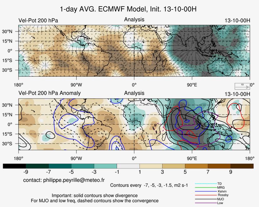
Thanks Philippe for pointing out. This one is a really strong Kelvin wave, that caught up the MJO envelope.
A textbook case ! #CCKW
Another one expected by the end of the week.
A textbook case ! #CCKW
Another one expected by the end of the week.

July 27, 2025 at 2:38 PM
Thanks Philippe for pointing out. This one is a really strong Kelvin wave, that caught up the MJO envelope.
A textbook case ! #CCKW
Another one expected by the end of the week.
A textbook case ! #CCKW
Another one expected by the end of the week.
L'imposante quantité de poussières se devine sur l'image MTG ce matin.

March 29, 2025 at 5:07 PM
L'imposante quantité de poussières se devine sur l'image MTG ce matin.
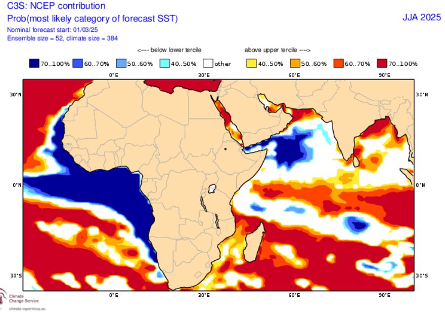
African monsoon - Seasonal forecast.
What's happening to NCEP SST this year ?
What's happening to NCEP SST this year ?

March 11, 2025 at 6:30 PM
African monsoon - Seasonal forecast.
What's happening to NCEP SST this year ?
What's happening to NCEP SST this year ?
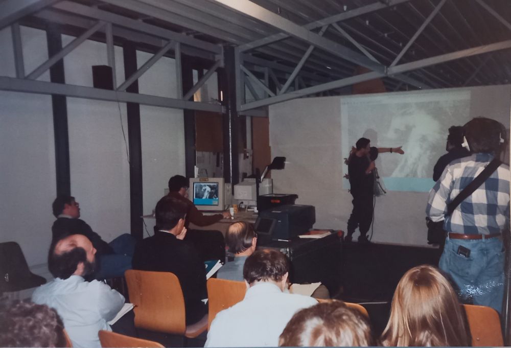
If I remember well, this must be Melvyn Shapiro's weather briefing during FASTEX experiment in Shannon, Ireland in 1997. Such a great memory.
A kind of two-headed baoclinic beast 🤩.
My personal picture.
A kind of two-headed baoclinic beast 🤩.
My personal picture.
February 6, 2025 at 8:22 PM
If I remember well, this must be Melvyn Shapiro's weather briefing during FASTEX experiment in Shannon, Ireland in 1997. Such a great memory.
A kind of two-headed baoclinic beast 🤩.
My personal picture.
A kind of two-headed baoclinic beast 🤩.
My personal picture.
and what a shift between Tuesday's run and Wedsnesday's run !

February 1, 2025 at 8:41 AM
and what a shift between Tuesday's run and Wedsnesday's run !

#EOWYN
Maybe the first time I see both UKMO and DWD adopting the Shapiro-Keyser cyclone model on their surface chart: warm seclusion, frontal fracture.
Question to UK colleague forecasters: why aren't the storm names marked on the Met Office map ?
( the Météo-France map on the right )
Maybe the first time I see both UKMO and DWD adopting the Shapiro-Keyser cyclone model on their surface chart: warm seclusion, frontal fracture.
Question to UK colleague forecasters: why aren't the storm names marked on the Met Office map ?
( the Météo-France map on the right )


January 24, 2025 at 10:20 AM
#EOWYN
Maybe the first time I see both UKMO and DWD adopting the Shapiro-Keyser cyclone model on their surface chart: warm seclusion, frontal fracture.
Question to UK colleague forecasters: why aren't the storm names marked on the Met Office map ?
( the Météo-France map on the right )
Maybe the first time I see both UKMO and DWD adopting the Shapiro-Keyser cyclone model on their surface chart: warm seclusion, frontal fracture.
Question to UK colleague forecasters: why aren't the storm names marked on the Met Office map ?
( the Météo-France map on the right )
Maybe the first time I see the UKMO adopting the Shapiro-Keyser cyclone model on their surface chart: warm seclusion, frontal fracture.
Question to UK colleague forecasters: why aren't the storm names marked on the Met Office map ?
( the Météo-France map on the right )
Question to UK colleague forecasters: why aren't the storm names marked on the Met Office map ?
( the Météo-France map on the right )


January 23, 2025 at 10:21 PM
Maybe the first time I see the UKMO adopting the Shapiro-Keyser cyclone model on their surface chart: warm seclusion, frontal fracture.
Question to UK colleague forecasters: why aren't the storm names marked on the Met Office map ?
( the Météo-France map on the right )
Question to UK colleague forecasters: why aren't the storm names marked on the Met Office map ?
( the Météo-France map on the right )
Il y a 40 ans, 15 janvier 1985. Je vous parle d'un temps que les moins de quarante ans ne peuvent pas et ne pourront plus connaître...Paris en ce temps-là en avait marre de la vague de froid. 🥶
Source: archives personnelles, Le Monde, je crois ?
Source: archives personnelles, Le Monde, je crois ?

January 15, 2025 at 2:10 PM
Il y a 40 ans, 15 janvier 1985. Je vous parle d'un temps que les moins de quarante ans ne peuvent pas et ne pourront plus connaître...Paris en ce temps-là en avait marre de la vague de froid. 🥶
Source: archives personnelles, Le Monde, je crois ?
Source: archives personnelles, Le Monde, je crois ?
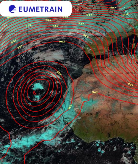
Dakar - Sénégal. Il pleut en saison sèche !
Un épisode de panache tropical: air humide transporté à partir de la ZCIT à l'avant d'une dépression isolée en altitude (cut-off low), forme une couche épaisse de nuages moyens-élevés.
Voir p119 du manuel du prévisionniste
Sources: EUMETView, Eumetrain
Un épisode de panache tropical: air humide transporté à partir de la ZCIT à l'avant d'une dépression isolée en altitude (cut-off low), forme une couche épaisse de nuages moyens-élevés.
Voir p119 du manuel du prévisionniste
Sources: EUMETView, Eumetrain


December 5, 2024 at 5:28 PM
Dakar - Sénégal. Il pleut en saison sèche !
Un épisode de panache tropical: air humide transporté à partir de la ZCIT à l'avant d'une dépression isolée en altitude (cut-off low), forme une couche épaisse de nuages moyens-élevés.
Voir p119 du manuel du prévisionniste
Sources: EUMETView, Eumetrain
Un épisode de panache tropical: air humide transporté à partir de la ZCIT à l'avant d'une dépression isolée en altitude (cut-off low), forme une couche épaisse de nuages moyens-élevés.
Voir p119 du manuel du prévisionniste
Sources: EUMETView, Eumetrain
📢 Tripoli and Northwestern Libya - Heavy rain ⛈️
Residents should remain attentive to the weather warnings and recommendations of the relevant authorities.
Intense thundershowers expected.
Risk of high impact weather to be seriously considered.
👏 Spotlight on WMO website
severeweather.wmo.int
Residents should remain attentive to the weather warnings and recommendations of the relevant authorities.
Intense thundershowers expected.
Risk of high impact weather to be seriously considered.
👏 Spotlight on WMO website
severeweather.wmo.int

December 5, 2024 at 12:16 PM
📢 Tripoli and Northwestern Libya - Heavy rain ⛈️
Residents should remain attentive to the weather warnings and recommendations of the relevant authorities.
Intense thundershowers expected.
Risk of high impact weather to be seriously considered.
👏 Spotlight on WMO website
severeweather.wmo.int
Residents should remain attentive to the weather warnings and recommendations of the relevant authorities.
Intense thundershowers expected.
Risk of high impact weather to be seriously considered.
👏 Spotlight on WMO website
severeweather.wmo.int
Remarquable exemple de communication de l'incertitude sur le scénario synoptique à moyenne échéance par le UKMO.
Je n'avais jamais vu ce genre de produits.
Un exemple à suivre ! 👍
Je n'avais jamais vu ce genre de produits.
Un exemple à suivre ! 👍

Cold northerly winds are expected to affect the UK by early next week, while a rain-bearing Atlantic low could bring more unsettled weather.
There's some uncertainty about the depth and track of this low and whether it brings rain, snow, or strong winds 🌧️ ❄️ 💨
There's some uncertainty about the depth and track of this low and whether it brings rain, snow, or strong winds 🌧️ ❄️ 💨

November 14, 2024 at 7:53 PM
Remarquable exemple de communication de l'incertitude sur le scénario synoptique à moyenne échéance par le UKMO.
Je n'avais jamais vu ce genre de produits.
Un exemple à suivre ! 👍
Je n'avais jamais vu ce genre de produits.
Un exemple à suivre ! 👍
Brouillards d'évaporation le long des rivières en République Démocratique du Congo, vus par le satellite MTG, 05h locales

November 13, 2024 at 8:39 AM
Brouillards d'évaporation le long des rivières en République Démocratique du Congo, vus par le satellite MTG, 05h locales
Northern Iceland. 04 am. Amazing November températures. 19 degrees. 🤪

November 12, 2024 at 5:59 AM
Northern Iceland. 04 am. Amazing November températures. 19 degrees. 🤪
Reposted by Thierry Lefort

Really happy to see the @metoffice.bsky.social on here now! Give them a warm welcome and a follow.
Also, it should be a great step toward getting other government agencies in weather and climate on here (e.g. U.S. National Weather Service offices and centers).
Also, it should be a great step toward getting other government agencies in weather and climate on here (e.g. U.S. National Weather Service offices and centers).
November 7, 2024 at 10:54 AM
Really happy to see the @metoffice.bsky.social on here now! Give them a warm welcome and a follow.
Also, it should be a great step toward getting other government agencies in weather and climate on here (e.g. U.S. National Weather Service offices and centers).
Also, it should be a great step toward getting other government agencies in weather and climate on here (e.g. U.S. National Weather Service offices and centers).
The African Weather Online Briefing series continues in October – Registrations open.
Présenté par le Service Météorologique du Kenya
30 octobre, 09UTC
@eumetsat.bsky.social
Présenté par le Service Météorologique du Kenya
30 octobre, 09UTC
@eumetsat.bsky.social

October 21, 2024 at 2:32 PM
The African Weather Online Briefing series continues in October – Registrations open.
Présenté par le Service Météorologique du Kenya
30 octobre, 09UTC
@eumetsat.bsky.social
Présenté par le Service Météorologique du Kenya
30 octobre, 09UTC
@eumetsat.bsky.social


Sumatra - dry spell ahead 🌞
Wave - filtered anomalies of 850 wind (arrows) and Precipitable Water (shading) based on ecwmf HRES (source CNRM, Météo-France): Low Frequency (120 days filtered) and the MJO (left) bring a strong contribution to dry westerlies.
+ dry phase of ER wave + Kelvin wave !
Wave - filtered anomalies of 850 wind (arrows) and Precipitable Water (shading) based on ecwmf HRES (source CNRM, Météo-France): Low Frequency (120 days filtered) and the MJO (left) bring a strong contribution to dry westerlies.
+ dry phase of ER wave + Kelvin wave !


October 17, 2024 at 3:41 PM
Sumatra - dry spell ahead 🌞
Wave - filtered anomalies of 850 wind (arrows) and Precipitable Water (shading) based on ecwmf HRES (source CNRM, Météo-France): Low Frequency (120 days filtered) and the MJO (left) bring a strong contribution to dry westerlies.
+ dry phase of ER wave + Kelvin wave !
Wave - filtered anomalies of 850 wind (arrows) and Precipitable Water (shading) based on ecwmf HRES (source CNRM, Météo-France): Low Frequency (120 days filtered) and the MJO (left) bring a strong contribution to dry westerlies.
+ dry phase of ER wave + Kelvin wave !
Quelqu'un peut-il me dire comment on fait un fil de plusieurs posts sur Bluesky ? Merci d'avance !
October 17, 2024 at 3:34 PM
Quelqu'un peut-il me dire comment on fait un fil de plusieurs posts sur Bluesky ? Merci d'avance !
Sumatra 🇮🇩 very dry spell starting this week-end, as shown by ecmwf model weekly rainfall anomaly (left), EFI (extreme forecast index for 10-day rain accumulation: middle) and meteogram for Padang (right).


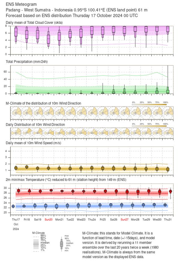
October 17, 2024 at 3:31 PM
Sumatra 🇮🇩 very dry spell starting this week-end, as shown by ecmwf model weekly rainfall anomaly (left), EFI (extreme forecast index for 10-day rain accumulation: middle) and meteogram for Padang (right).
Filtering product from CNRM, Météo-France (based on ecmwf model) shows a strong contribution from the MJO to the vorticity at 850hPa (arrows) and Precipitable Water (blue as positive anomaly) in the northern Arabian Sea, together with the Equ. Rossby wave.


October 13, 2024 at 2:58 PM
Filtering product from CNRM, Météo-France (based on ecmwf model) shows a strong contribution from the MJO to the vorticity at 850hPa (arrows) and Precipitable Water (blue as positive anomaly) in the northern Arabian Sea, together with the Equ. Rossby wave.
Strong Westerly Wind Burst has reached Sumatra 🇮🇩
Robust Kelvin wave superimposed on the MJO, and a bit of a contribution from Equ. Rossby wave. All on top of a westerly, low frequency anomaly at 850hPa.
Source CIMSS and CNRM, Météo-France: MISVA website
Robust Kelvin wave superimposed on the MJO, and a bit of a contribution from Equ. Rossby wave. All on top of a westerly, low frequency anomaly at 850hPa.
Source CIMSS and CNRM, Météo-France: MISVA website


October 13, 2024 at 2:35 PM
Strong Westerly Wind Burst has reached Sumatra 🇮🇩
Robust Kelvin wave superimposed on the MJO, and a bit of a contribution from Equ. Rossby wave. All on top of a westerly, low frequency anomaly at 850hPa.
Source CIMSS and CNRM, Météo-France: MISVA website
Robust Kelvin wave superimposed on the MJO, and a bit of a contribution from Equ. Rossby wave. All on top of a westerly, low frequency anomaly at 850hPa.
Source CIMSS and CNRM, Météo-France: MISVA website