


Thomas Geboy
@thomasgeboy.bsky.social
Chief Meteorologist NBC 15 in Mobile, AL. NWA Seal of Approval. Opinions are mine.
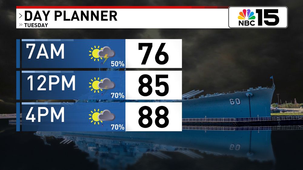
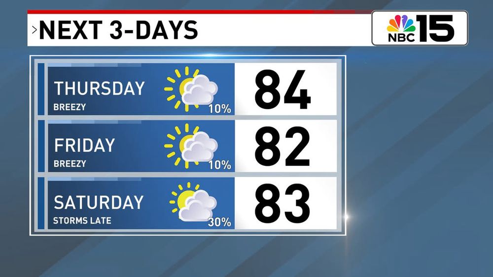
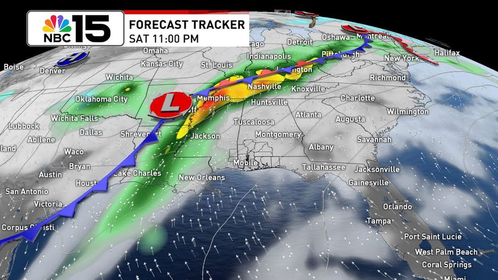
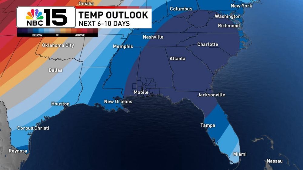
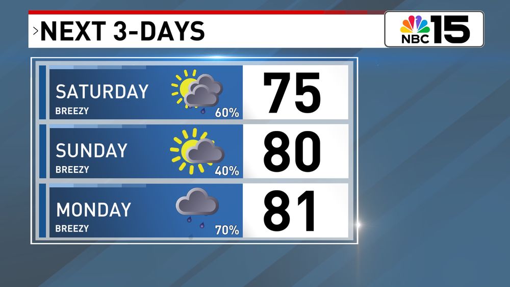
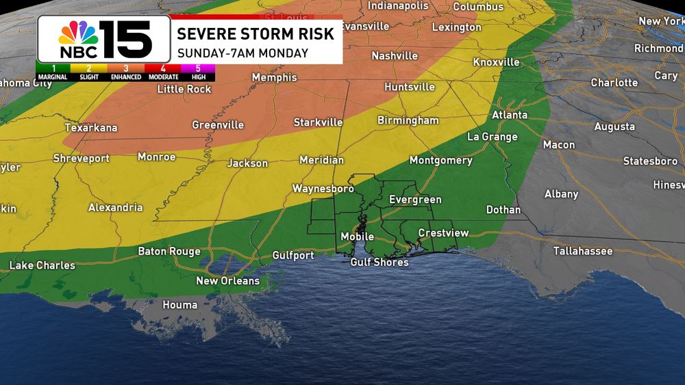
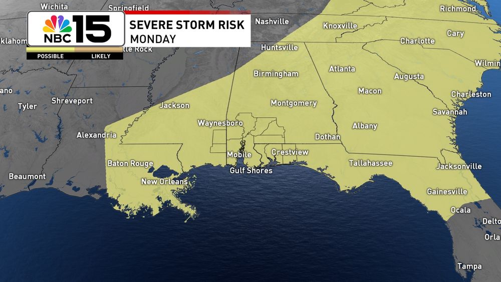
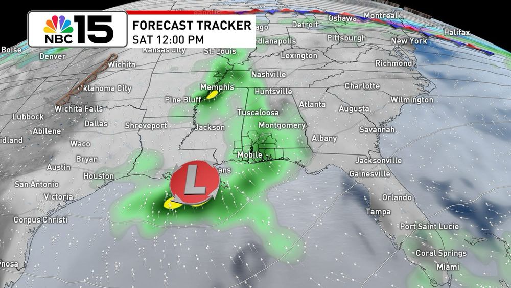
Tracking Gabrielle and a couple of disturbances, but still so far so good in the tropics concerning the Gulf. At home it’s more of the same in the coming days, just with a small uptick in moisture. Next week still looking decent for better rain chances.
September 18, 2025 at 12:06 AM
Tracking Gabrielle and a couple of disturbances, but still so far so good in the tropics concerning the Gulf. At home it’s more of the same in the coming days, just with a small uptick in moisture. Next week still looking decent for better rain chances.
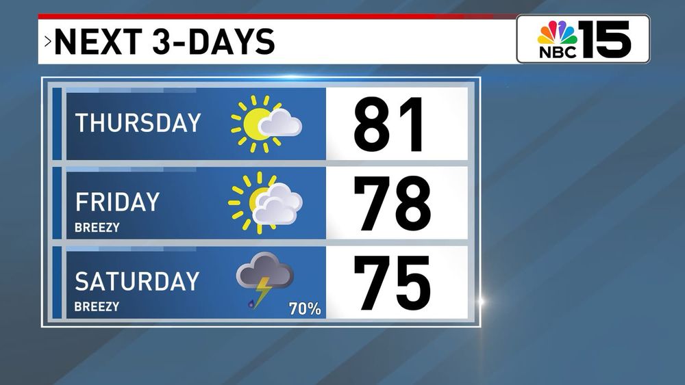
In the tropics, there’s a high chance the disturbance in the east Atlantic develops by this weekend. We’ll watch, but there are no foreseeable tropical threats to the Gulf through the next 7-days. At home it’s a summer pattern with low rain chances for now.
September 4, 2025 at 12:23 AM
In the tropics, there’s a high chance the disturbance in the east Atlantic develops by this weekend. We’ll watch, but there are no foreseeable tropical threats to the Gulf through the next 7-days. At home it’s a summer pattern with low rain chances for now.
The pleasant weather hangs on for now, but by the end of this week there will be even more of a summer feel. In the tropics we’re watching a disturbance with a high chance of developing but there’s plenty of time to watch. @mynbc15.bsky.social
September 2, 2025 at 11:59 PM
The pleasant weather hangs on for now, but by the end of this week there will be even more of a summer feel. In the tropics we’re watching a disturbance with a high chance of developing but there’s plenty of time to watch. @mynbc15.bsky.social
Watching Erin and a tropical wave in the Atlantic, but for the time being, no imminent concerns for the Gulf. At home, it’s more heat with spotty storms through midweek before becoming unsettled late week. www.facebook.com/share/v/1aqA...


August 18, 2025 at 11:55 PM
Watching Erin and a tropical wave in the Atlantic, but for the time being, no imminent concerns for the Gulf. At home, it’s more heat with spotty storms through midweek before becoming unsettled late week. www.facebook.com/share/v/1aqA...
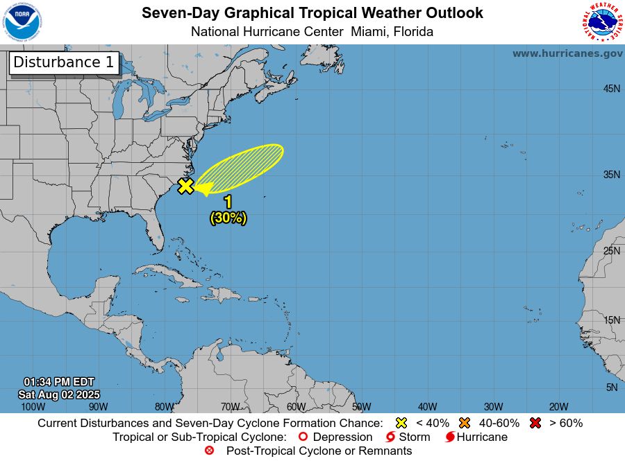
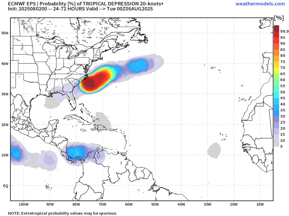
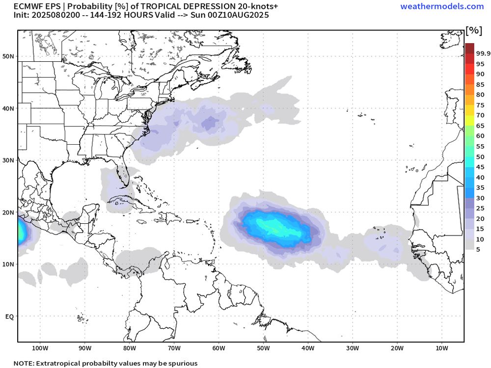
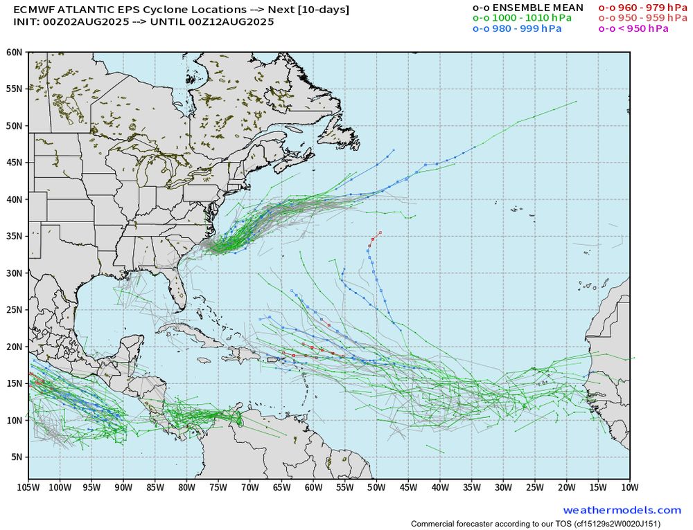
NHC has marked a disturbance off the coast of the Carolina’s with a low chance of developing as it moves northeast. The rest of the Atlantic basin remains quiet, but there are signs things could become a bit more active in the next week or two. Just something to monitor for now.
August 2, 2025 at 6:33 PM
NHC has marked a disturbance off the coast of the Carolina’s with a low chance of developing as it moves northeast. The rest of the Atlantic basin remains quiet, but there are signs things could become a bit more active in the next week or two. Just something to monitor for now.
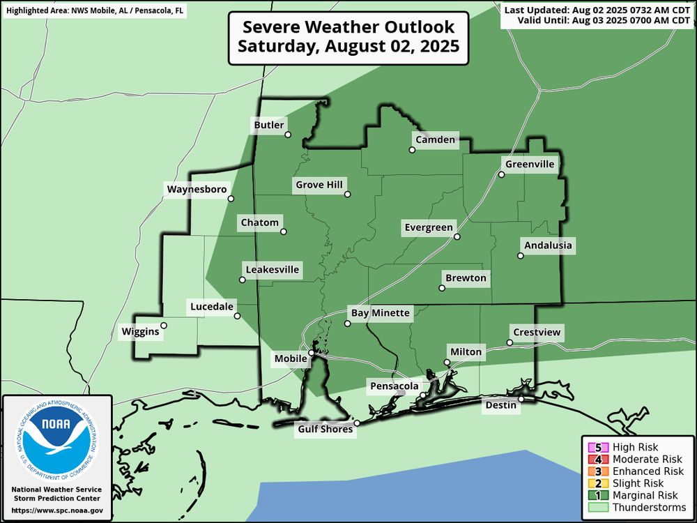
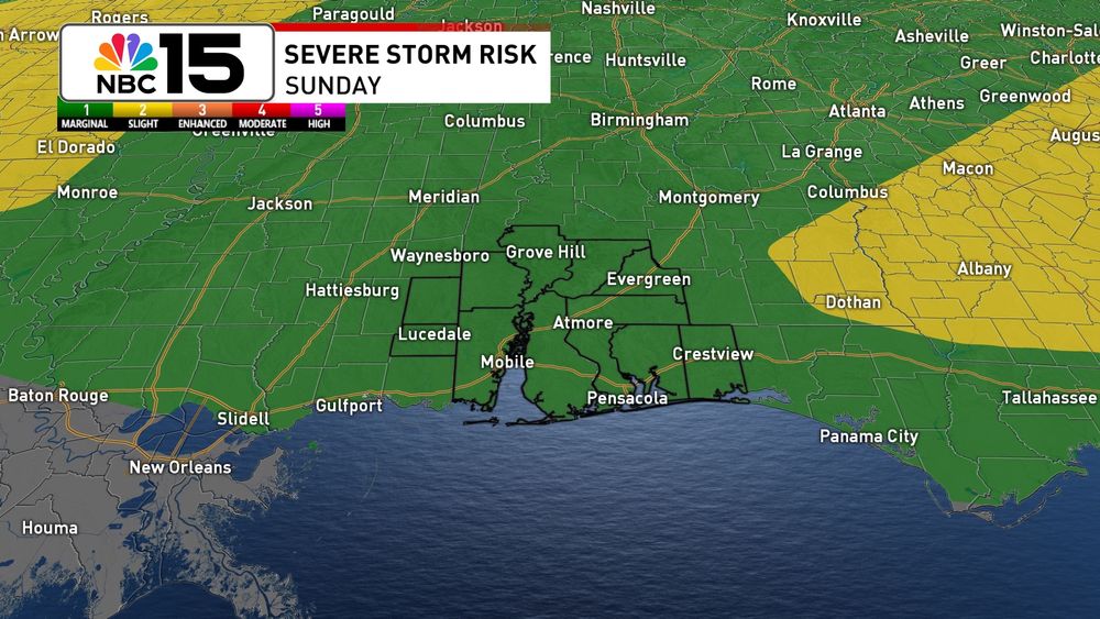
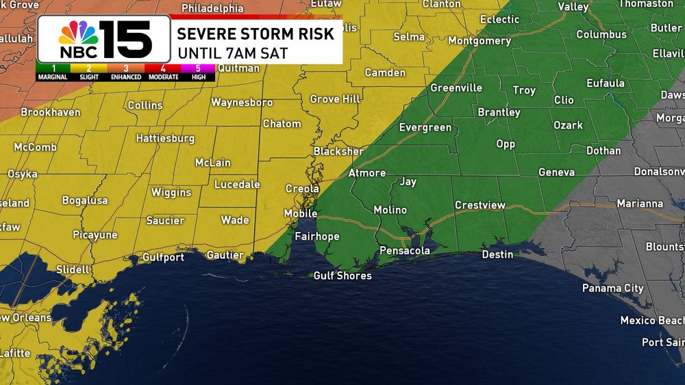
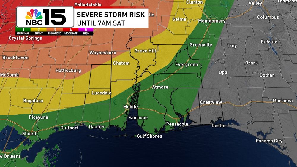
A marginal severe risk has been added to most of our area today. Storms will be capable of strong wind gusts.
August 2, 2025 at 2:41 PM
A marginal severe risk has been added to most of our area today. Storms will be capable of strong wind gusts.
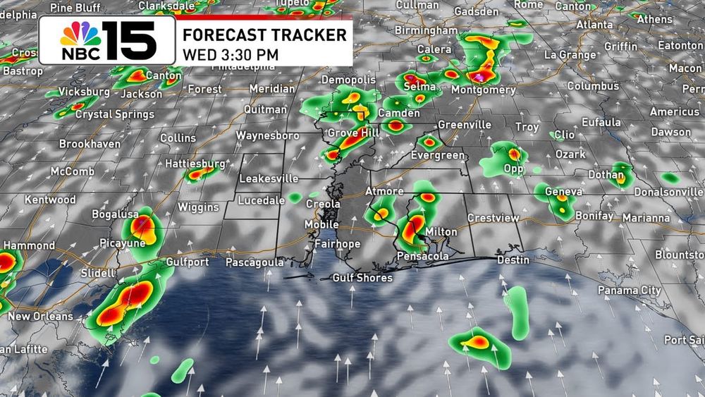
Another day of dodging showers and storms for our Wednesday. @mynbc15.bsky.social
June 18, 2025 at 4:42 AM
Another day of dodging showers and storms for our Wednesday. @mynbc15.bsky.social
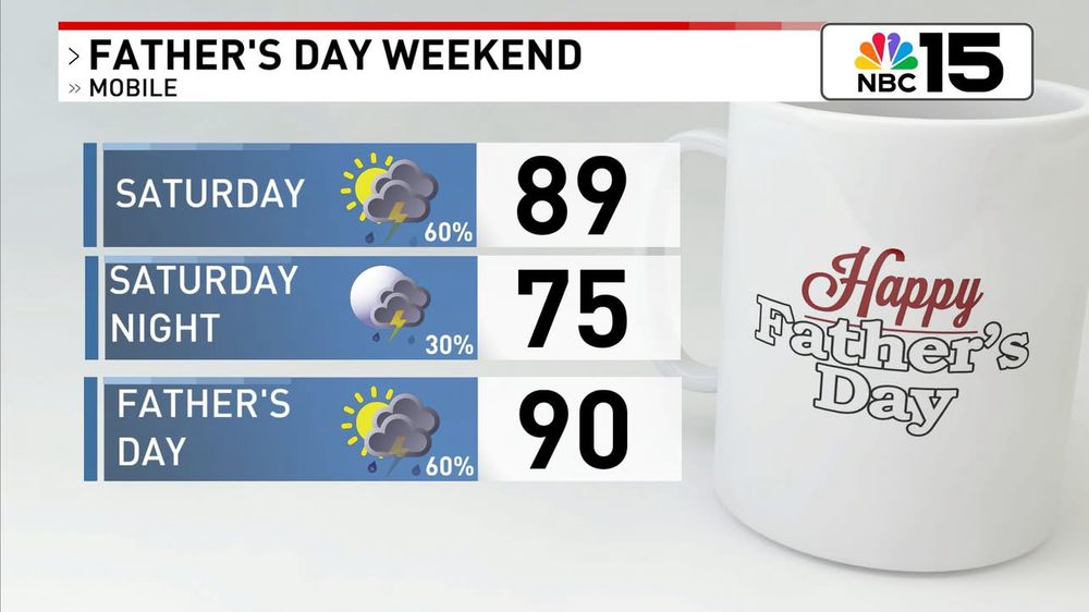
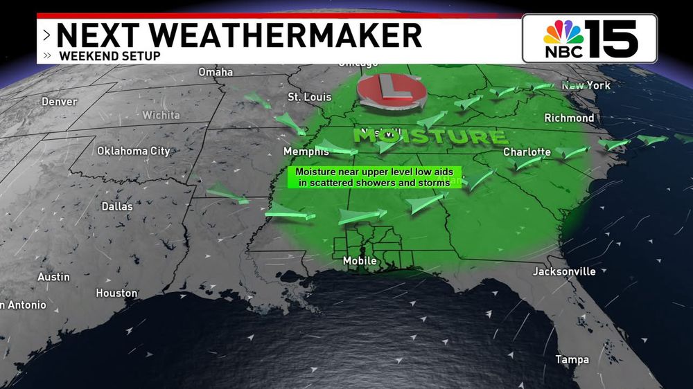
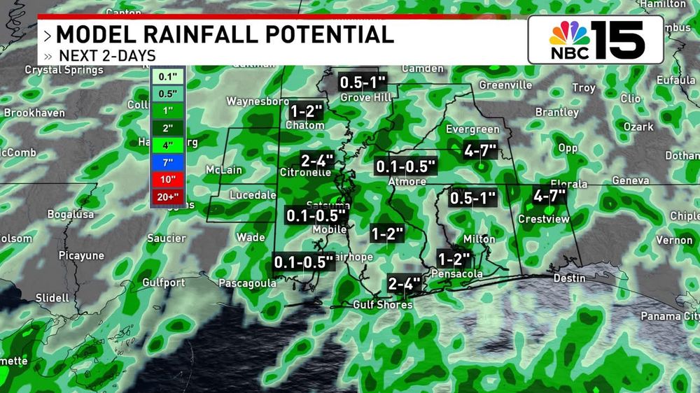
More of the same for the Father's Day weekend with elevated rain chances, highs near 90, and heat indices near 100°. While neither day looks like a washout, have a backup just in case for any outside plans with dad! @mynbc15.bsky.social
June 14, 2025 at 3:50 AM
More of the same for the Father's Day weekend with elevated rain chances, highs near 90, and heat indices near 100°. While neither day looks like a washout, have a backup just in case for any outside plans with dad! @mynbc15.bsky.social
Tomorrow won't bring non-stop rain, but some spots could see multiple rounds. Outside of any wet weather skies will be partly sunny with upper 80s for highs. Thanks to the humidity, it will feel closer to 100° with the heat index. @mynbc15.bsky.social
June 10, 2025 at 3:54 AM
Tomorrow won't bring non-stop rain, but some spots could see multiple rounds. Outside of any wet weather skies will be partly sunny with upper 80s for highs. Thanks to the humidity, it will feel closer to 100° with the heat index. @mynbc15.bsky.social
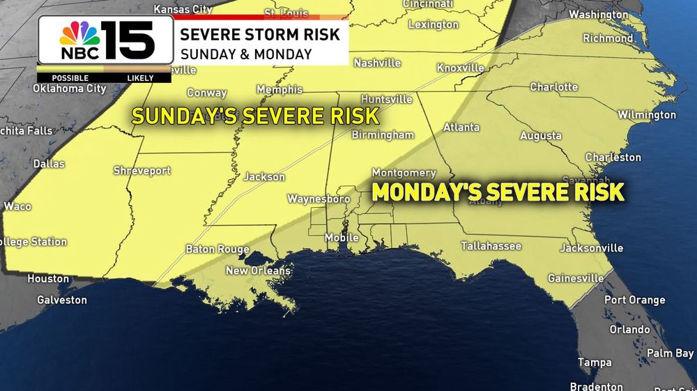
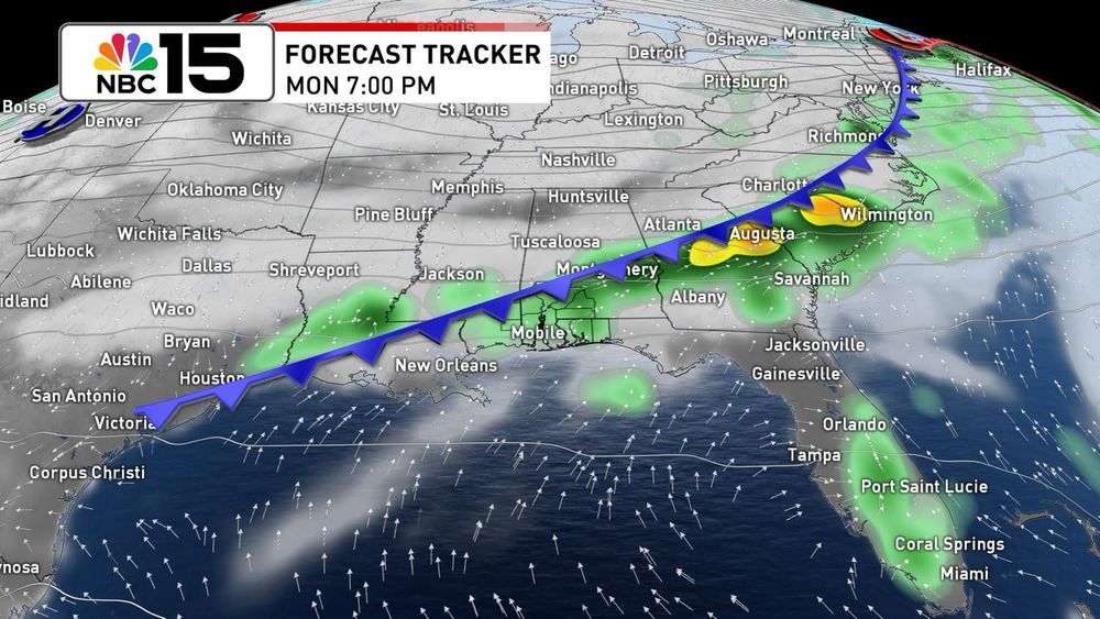
Cranking up the heat a little more this weekend with more storm potential! Storms will be a little spottier on Saturday while Sunday will bring better coverage. A low-end severe risk will exist both days with winds being the primary risk.
June 7, 2025 at 5:14 AM
Cranking up the heat a little more this weekend with more storm potential! Storms will be a little spottier on Saturday while Sunday will bring better coverage. A low-end severe risk will exist both days with winds being the primary risk.
Scattered storms moving from east to west this afternoon. Keep the umbrella handy!

June 4, 2025 at 7:57 PM
Scattered storms moving from east to west this afternoon. Keep the umbrella handy!
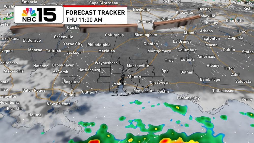
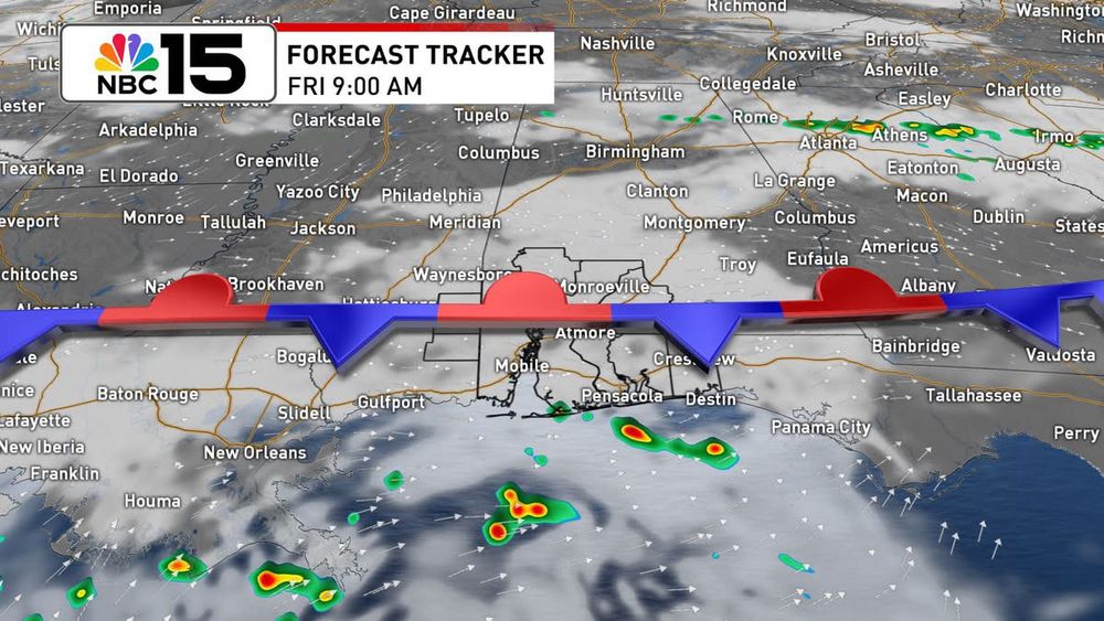
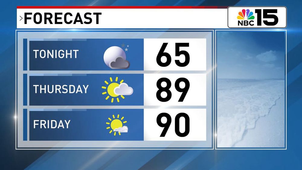
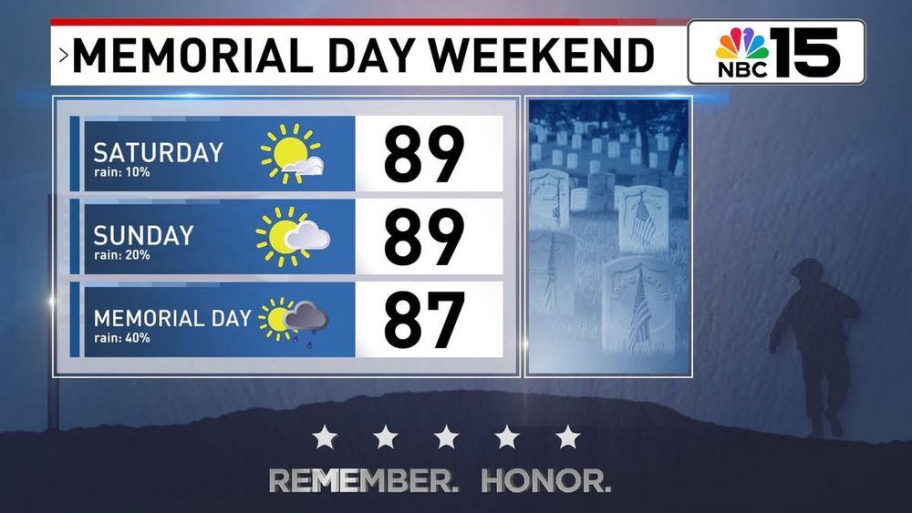
Outside of a slim chance of spotty showers near the coast the next couple of days, we'll end the workweek mostly dry with highs near 90 while low stay comfy in the 60s. Moisture levels will start to pick back up during the Memorial Day weekend. @mynbc15.bsky.social
May 22, 2025 at 3:36 AM
Outside of a slim chance of spotty showers near the coast the next couple of days, we'll end the workweek mostly dry with highs near 90 while low stay comfy in the 60s. Moisture levels will start to pick back up during the Memorial Day weekend. @mynbc15.bsky.social
Comfortable tonight, then warm and breezy for the second half of the workweek with mostly dry skies! @mynbc15.bsky.social
May 14, 2025 at 3:13 AM
Comfortable tonight, then warm and breezy for the second half of the workweek with mostly dry skies! @mynbc15.bsky.social
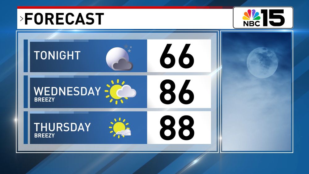
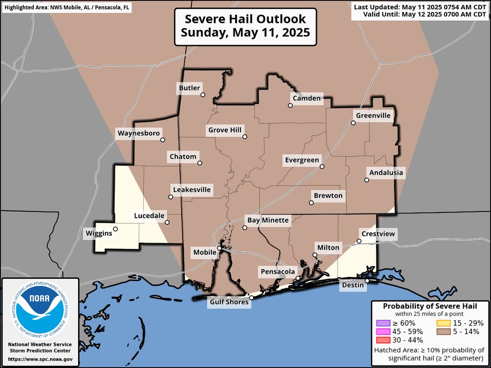
Low-end severe risk again today for storms that developed. Mainly a wind and hail threat, but a brief tornado risk will exist for the eastern part of our area.
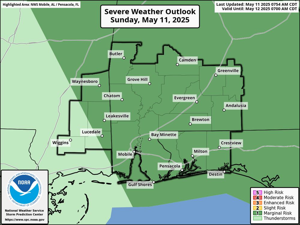
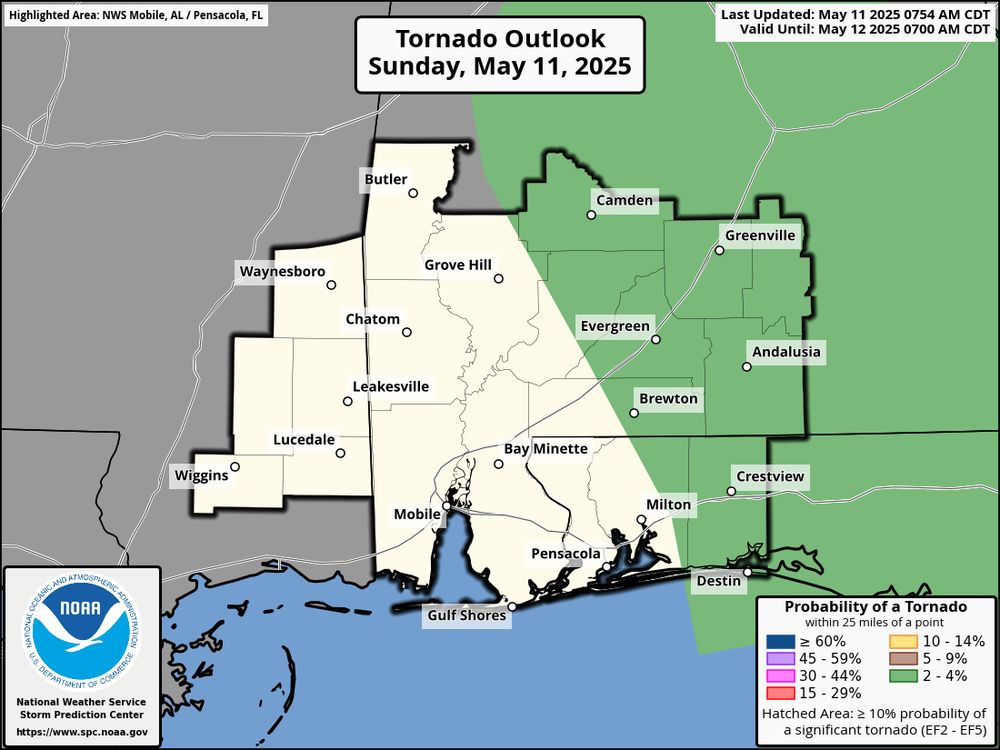
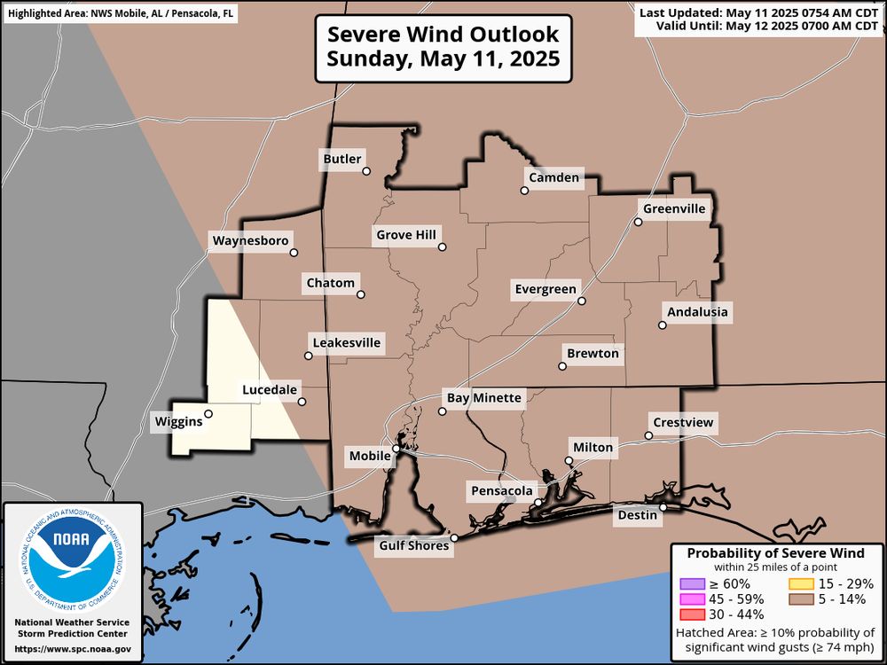
May 11, 2025 at 5:55 PM
Low-end severe risk again today for storms that developed. Mainly a wind and hail threat, but a brief tornado risk will exist for the eastern part of our area.
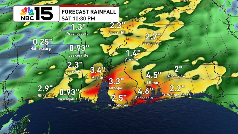
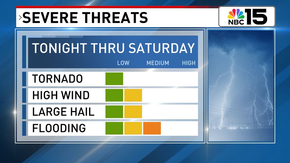
The radar is quiet now, but that will be changing soon. Showers and t'storms will spread across our area late tonight into Saturday as a cold front sweeps across our area. Times of heavy rain and a few strong to severe storms will be possible. @mynbc15.bsky.social
May 2, 2025 at 11:29 PM
The radar is quiet now, but that will be changing soon. Showers and t'storms will spread across our area late tonight into Saturday as a cold front sweeps across our area. Times of heavy rain and a few strong to severe storms will be possible. @mynbc15.bsky.social
All modes of severe weather remain possible today ahead of the cold front. Even after the front passes, showers will persist into Monday. There's a slight risk of excessive rainfall for our area today & tonight. Here’s a quick update. @mynbc15.bsky.social
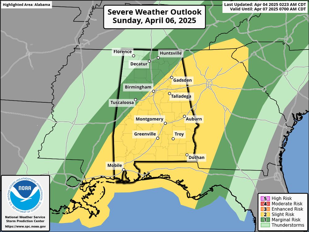
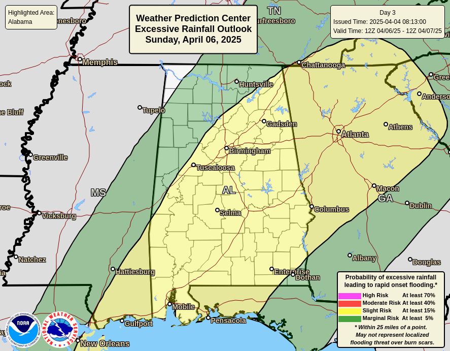
April 6, 2025 at 5:18 PM
All modes of severe weather remain possible today ahead of the cold front. Even after the front passes, showers will persist into Monday. There's a slight risk of excessive rainfall for our area today & tonight. Here’s a quick update. @mynbc15.bsky.social
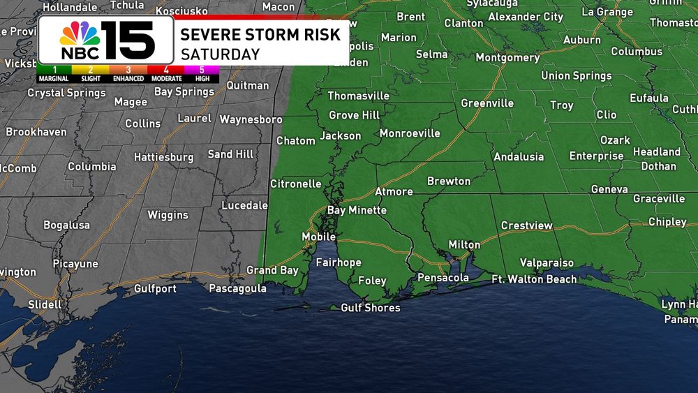
Our Weathermaker on Sunday will bring a level 2 slight risk of severe weather and excessive rainfall. If we see severe weather, winds will be the primary concern, but an isolated tornado threat can’t be completely ruled out.
April 4, 2025 at 6:25 PM
Our Weathermaker on Sunday will bring a level 2 slight risk of severe weather and excessive rainfall. If we see severe weather, winds will be the primary concern, but an isolated tornado threat can’t be completely ruled out.
A warm, breezy, and muggy night on the way with areas of patchy fog. No big changes in our weather through the daytime hours on Saturday, but from Saturday night into Sunday our next weathermaker will bring storms, then cooler air into next week. Details tonight on @mynbc15.bsky.social!
April 2, 2025 at 8:48 PM
A warm, breezy, and muggy night on the way with areas of patchy fog. No big changes in our weather through the daytime hours on Saturday, but from Saturday night into Sunday our next weathermaker will bring storms, then cooler air into next week. Details tonight on @mynbc15.bsky.social!
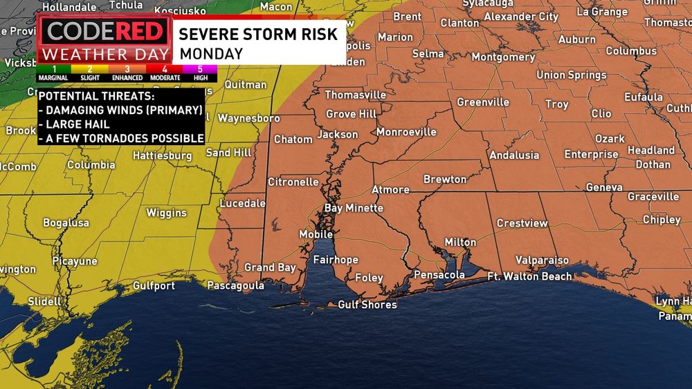
Most of our area is now in a level 3/5 enhanced risk of severe weather Monday as our next Weathermaker moves in. Damaging winds are still the primary concerns, but hail, a few tornadoes, and heavy rain will all be possible. Stay aware and have a plan just in case. @mynbc15.bsky.social
March 31, 2025 at 2:45 AM
Most of our area is now in a level 3/5 enhanced risk of severe weather Monday as our next Weathermaker moves in. Damaging winds are still the primary concerns, but hail, a few tornadoes, and heavy rain will all be possible. Stay aware and have a plan just in case. @mynbc15.bsky.social
Mild & breezy tonight, then becoming active this weekend as 2 Weathermakers get set to move through. The 1st will bring sct'rd showers Saturday, then from late Sunday into Monday the 2nd will bring a risk of isolated to scattered severe storms. Details on @mynbc15.bsky.social tonight!
March 28, 2025 at 11:39 PM
Mild & breezy tonight, then becoming active this weekend as 2 Weathermakers get set to move through. The 1st will bring sct'rd showers Saturday, then from late Sunday into Monday the 2nd will bring a risk of isolated to scattered severe storms. Details on @mynbc15.bsky.social tonight!
Quiet skies to end the workweek, then our next Weathermaker will bring showers and storms Saturday. Sunday then looks relatively quiet before a storm system will bring a slight risk of severe storms on Monday.
March 26, 2025 at 11:41 PM
Quiet skies to end the workweek, then our next Weathermaker will bring showers and storms Saturday. Sunday then looks relatively quiet before a storm system will bring a slight risk of severe storms on Monday.
Our next weathermaker moves in late tonight into tomorrow morning. We'll see scattered showers and storms, mainly through the first half of Monday. While the severe risk is low, it's not zero. By Tuesday we're back to sunshine as highs warm to the 80s! @mynbc15.bsky.social
March 24, 2025 at 2:54 AM
Our next weathermaker moves in late tonight into tomorrow morning. We'll see scattered showers and storms, mainly through the first half of Monday. While the severe risk is low, it's not zero. By Tuesday we're back to sunshine as highs warm to the 80s! @mynbc15.bsky.social
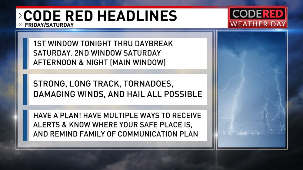
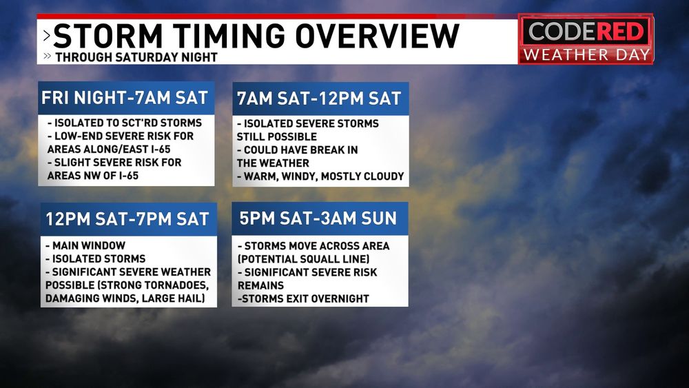
After a warm, wind, and relatively quiet day, the risk of severe weather ramps up tonight before a significant severe risk Saturday. Strong tornadoes, damaging straight line winds, and hail all will be possible. Stay alert and have a plan! @mynbc15.bsky.social
March 14, 2025 at 11:08 PM
After a warm, wind, and relatively quiet day, the risk of severe weather ramps up tonight before a significant severe risk Saturday. Strong tornadoes, damaging straight line winds, and hail all will be possible. Stay alert and have a plan! @mynbc15.bsky.social
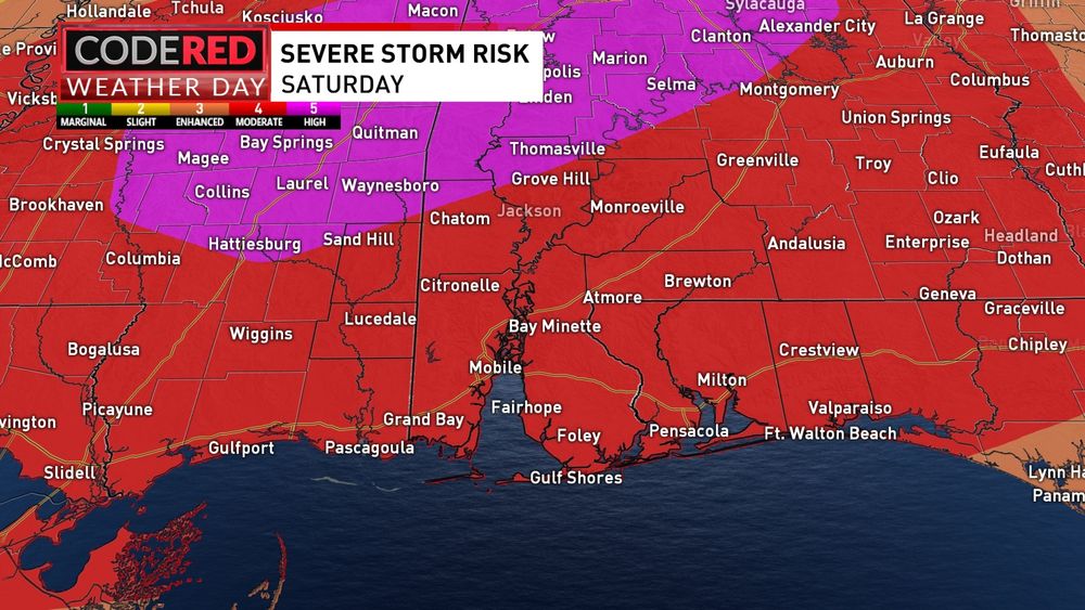
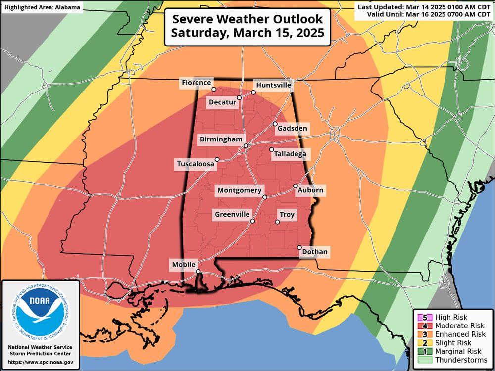
All of the @mynbc15.bsky.social area has now been placed in the level 4 MODERATE RISK for Saturday. Scattered to numerous severe storms will be likely & significant severe weather (EF2+ tornadoes & wind gusts >75mph) will be possible. Have a plan, & know where your safe place is!
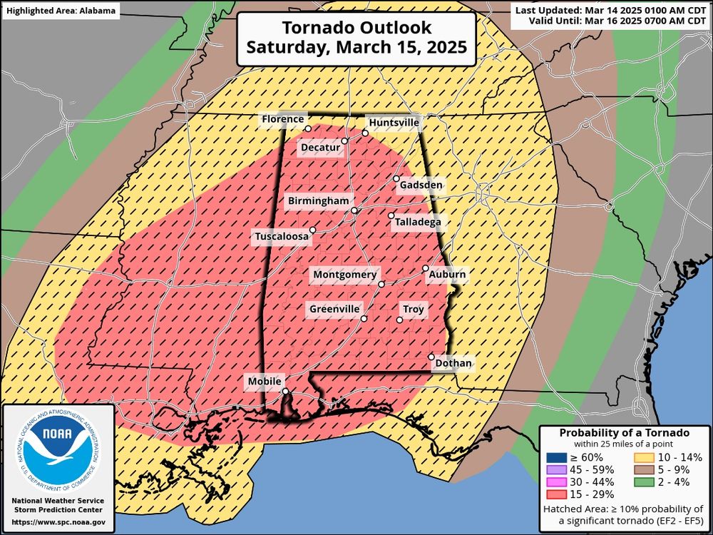
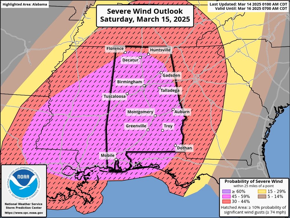
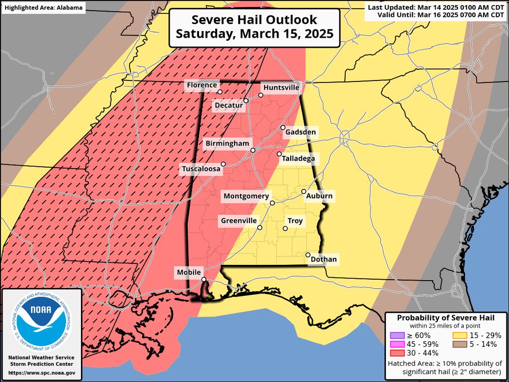
March 14, 2025 at 6:15 AM
All of the @mynbc15.bsky.social area has now been placed in the level 4 MODERATE RISK for Saturday. Scattered to numerous severe storms will be likely & significant severe weather (EF2+ tornadoes & wind gusts >75mph) will be possible. Have a plan, & know where your safe place is!
The SPC risk for Saturday had been released and it shows most of the @mynbc15.bsky.social in a level 4 MODERATE RISK. That means scattered to numerous severe storms are expected. Make sure you’re prepared before we get to Saturday. Have a plan and multiple ways to receive alerts!
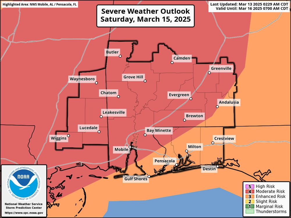
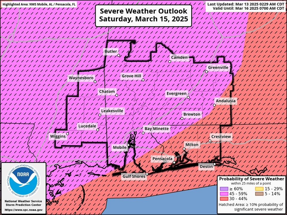
March 13, 2025 at 7:52 AM
The SPC risk for Saturday had been released and it shows most of the @mynbc15.bsky.social in a level 4 MODERATE RISK. That means scattered to numerous severe storms are expected. Make sure you’re prepared before we get to Saturday. Have a plan and multiple ways to receive alerts!