


Thomas Ansart
@thomasansart.bsky.social
Cartography and datavisualization at Sciences Po - Atelier de cartographie
The "Atlantis" projection by John Ian Bartholomew
For example: www.davidrumsey.com/luna/servlet...
Available in d3: observablehq.com/@d3/atlantis
For example: www.davidrumsey.com/luna/servlet...
Available in d3: observablehq.com/@d3/atlantis
www.davidrumsey.com
May 19, 2025 at 7:32 AM
The "Atlantis" projection by John Ian Bartholomew
For example: www.davidrumsey.com/luna/servlet...
Available in d3: observablehq.com/@d3/atlantis
For example: www.davidrumsey.com/luna/servlet...
Available in d3: observablehq.com/@d3/atlantis
Excellent!
Changing projection is another approach we tried but it can be harder to identify countries shapes.
bsky.app/profile/thom...
Changing projection is another approach we tried but it can be harder to identify countries shapes.
bsky.app/profile/thom...
Very nice!
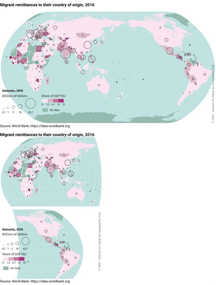
A few years back we faced the same problem and tried different solutions.
From using a different projection to cutting the map and even rotating it.
espace-mondial-atlas.sciencespo.fr/en/topic-res...
A few years back we faced the same problem and tried different solutions.
From using a different projection to cutting the map and even rotating it.
espace-mondial-atlas.sciencespo.fr/en/topic-res...


May 15, 2025 at 9:53 AM
Excellent!
Changing projection is another approach we tried but it can be harder to identify countries shapes.
bsky.app/profile/thom...
Changing projection is another approach we tried but it can be harder to identify countries shapes.
bsky.app/profile/thom...
Very nice!
A few years back we faced the same problem and tried different solutions.
From using a different projection to cutting the map and even rotating it.
espace-mondial-atlas.sciencespo.fr/en/topic-res...
A few years back we faced the same problem and tried different solutions.
From using a different projection to cutting the map and even rotating it.
espace-mondial-atlas.sciencespo.fr/en/topic-res...
April 28, 2025 at 9:39 AM
Very nice!
A few years back we faced the same problem and tried different solutions.
From using a different projection to cutting the map and even rotating it.
espace-mondial-atlas.sciencespo.fr/en/topic-res...
A few years back we faced the same problem and tried different solutions.
From using a different projection to cutting the map and even rotating it.
espace-mondial-atlas.sciencespo.fr/en/topic-res...