


stormy sound the furry
@stormysoundfurry.bsky.social
Furry, shitposter and occasional person who thinks.
https://stormysound.carrd.co
A bit too into meterology :3
Follow if you want weather you dont care about mixed with weird furry shit.
https://stormysound.carrd.co
A bit too into meterology :3
Follow if you want weather you dont care about mixed with weird furry shit.
(Unnoficial)
We have THREE areas of possible development in the long term for #Cyclones
these are all 10-14 days out, so models are to be taken with a huge amount of salt.
Depression 91W Died out, and #FUNGWONG has just gone past Taiwan as a tropical storm.
CURRENT STORMS:
FUNG WONG
#Weather
We have THREE areas of possible development in the long term for #Cyclones
these are all 10-14 days out, so models are to be taken with a huge amount of salt.
Depression 91W Died out, and #FUNGWONG has just gone past Taiwan as a tropical storm.
CURRENT STORMS:
FUNG WONG
#Weather

November 13, 2025 at 4:45 AM

Most models are showing some form of development in the long term, could get a #Cyclone forming from #WA #NT or #QLD #AUSTRALIA with impacts to #PAPUANEWGUINEA and #INDONESIA In about a weeks time.
watch this space, conditions could be excellent for formation.
watch this space, conditions could be excellent for formation.

November 12, 2025 at 4:40 AM
Most models are showing some form of development in the long term, could get a #Cyclone forming from #WA #NT or #QLD #AUSTRALIA with impacts to #PAPUANEWGUINEA and #INDONESIA In about a weeks time.
watch this space, conditions could be excellent for formation.
watch this space, conditions could be excellent for formation.
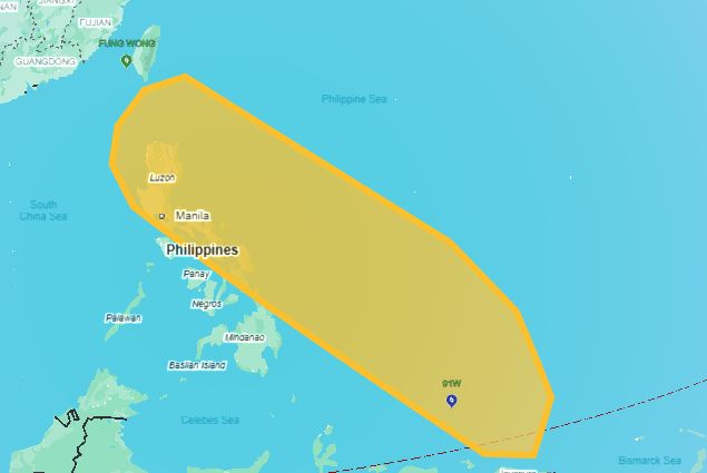
Invest 91W has formed, and has a LOW chance of forming in the next 24 Hours.
FURTHER OUT:
Should 91W form into a typhoon, unfortunately it seems as though it will shift west into the #Philippines
CURRENT SYSTEMS:
FUNG WONG (Ex Typhoon)
91W (Invest)
FURTHER OUT:
Should 91W form into a typhoon, unfortunately it seems as though it will shift west into the #Philippines
CURRENT SYSTEMS:
FUNG WONG (Ex Typhoon)
91W (Invest)
November 12, 2025 at 4:35 AM
Invest 91W has formed, and has a LOW chance of forming in the next 24 Hours.
FURTHER OUT:
Should 91W form into a typhoon, unfortunately it seems as though it will shift west into the #Philippines
CURRENT SYSTEMS:
FUNG WONG (Ex Typhoon)
91W (Invest)
FURTHER OUT:
Should 91W form into a typhoon, unfortunately it seems as though it will shift west into the #Philippines
CURRENT SYSTEMS:
FUNG WONG (Ex Typhoon)
91W (Invest)


November 9, 2025 at 12:06 PM
mf overshooting tops in a typhoon

November 9, 2025 at 8:57 AM
mf overshooting tops in a typhoon
#Typhoon #Fungwong or #Uwan Is about to make landfall in the next hour or so. hope for the best. the system is still around the same size as the whole country of the #Philippines
which has just taken a hit from kalmaegi a few days ago, killing over 200 people.
which has just taken a hit from kalmaegi a few days ago, killing over 200 people.

November 9, 2025 at 8:36 AM
#Typhoon #Fungwong or #Uwan Is about to make landfall in the next hour or so. hope for the best. the system is still around the same size as the whole country of the #Philippines
which has just taken a hit from kalmaegi a few days ago, killing over 200 people.
which has just taken a hit from kalmaegi a few days ago, killing over 200 people.
Meanwhile, google hellbent on this being a cat5

November 8, 2025 at 5:25 PM
Meanwhile, google hellbent on this being a cat5
Google deepmind still pretty sure its going to get to cat5. i dont think so, its too big but cat 4 isnt out of the question.

November 8, 2025 at 11:32 AM
Google deepmind still pretty sure its going to get to cat5. i dont think so, its too big but cat 4 isnt out of the question.
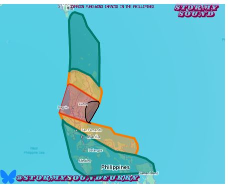
⬛ ALL RISKS: huge storm surge, strong winds and intense rainfall.
🟥 Heavy rainfall and strong winds expected with some surge to coastal areas.
🟧 Stay vigilant, areas of flooding and high winds expected
🟩 Localized flooding and fallen trees may pose a threat
#UWAN will make landfall in 2 Days.
🟥 Heavy rainfall and strong winds expected with some surge to coastal areas.
🟧 Stay vigilant, areas of flooding and high winds expected
🟩 Localized flooding and fallen trees may pose a threat
#UWAN will make landfall in 2 Days.
November 8, 2025 at 11:10 AM
⬛ ALL RISKS: huge storm surge, strong winds and intense rainfall.
🟥 Heavy rainfall and strong winds expected with some surge to coastal areas.
🟧 Stay vigilant, areas of flooding and high winds expected
🟩 Localized flooding and fallen trees may pose a threat
#UWAN will make landfall in 2 Days.
🟥 Heavy rainfall and strong winds expected with some surge to coastal areas.
🟧 Stay vigilant, areas of flooding and high winds expected
🟩 Localized flooding and fallen trees may pose a threat
#UWAN will make landfall in 2 Days.
cookie for u

November 7, 2025 at 9:06 AM
cookie for u

I mean judging from how organised it is already. think the only reason the forecast isnt showing it is the uncertanty of the conditions with the other typhoon right now.

November 5, 2025 at 11:31 AM
I mean judging from how organised it is already. think the only reason the forecast isnt showing it is the uncertanty of the conditions with the other typhoon right now.
This is clear sign that Tropical depression 32W is organising fast. Conditions are prime for rapid intensification. #Typhoon #Philippines #Cyclone #Fung-Wong #Uwan #Weather #forecast
November 5, 2025 at 11:29 AM
This is clear sign that Tropical depression 32W is organising fast. Conditions are prime for rapid intensification. #Typhoon #Philippines #Cyclone #Fung-Wong #Uwan #Weather #forecast

November 3, 2025 at 12:13 AM
#Hurricane #Melissa update:
It's now moving out of #Cuba and into the #Bahamas
It is now a category 2, with still devastating winds and storm surge expected from the area.
the death toll is now 16, with more expected in cuba and the bahamas, and likely far more as communications improve in jamaica.
It's now moving out of #Cuba and into the #Bahamas
It is now a category 2, with still devastating winds and storm surge expected from the area.
the death toll is now 16, with more expected in cuba and the bahamas, and likely far more as communications improve in jamaica.

October 29, 2025 at 2:51 PM
#Hurricane #Melissa update:
It's now moving out of #Cuba and into the #Bahamas
It is now a category 2, with still devastating winds and storm surge expected from the area.
the death toll is now 16, with more expected in cuba and the bahamas, and likely far more as communications improve in jamaica.
It's now moving out of #Cuba and into the #Bahamas
It is now a category 2, with still devastating winds and storm surge expected from the area.
the death toll is now 16, with more expected in cuba and the bahamas, and likely far more as communications improve in jamaica.

Godspeed #Jamaica
Our prayers are with you.
This is one of the worst situations for a hurricane.
#Hurricane #Mellissa #Weather #2025weather #Godspeed
Our prayers are with you.
This is one of the worst situations for a hurricane.
#Hurricane #Mellissa #Weather #2025weather #Godspeed

October 28, 2025 at 12:29 PM
Godspeed #Jamaica
Our prayers are with you.
This is one of the worst situations for a hurricane.
#Hurricane #Mellissa #Weather #2025weather #Godspeed
Our prayers are with you.
This is one of the worst situations for a hurricane.
#Hurricane #Mellissa #Weather #2025weather #Godspeed

October 28, 2025 at 4:14 AM
@galefrostbane.bsky.social @smellystrobes.bsky.social i hope these two posts are related

October 28, 2025 at 3:50 AM
@galefrostbane.bsky.social @smellystrobes.bsky.social i hope these two posts are related
Remain in your safe shelter & do not venture outside. Catastrophic, life-threatening flash flooding & numerous landslides through Tuesday as #Melissa's core moves ashore.
#jamaica. -NWS
This is one of the worst hurricanes ever.
200+mph gusts, 10 meter storm surge and movement speed of like 5mph.
#jamaica. -NWS
This is one of the worst hurricanes ever.
200+mph gusts, 10 meter storm surge and movement speed of like 5mph.

October 28, 2025 at 3:47 AM
Remain in your safe shelter & do not venture outside. Catastrophic, life-threatening flash flooding & numerous landslides through Tuesday as #Melissa's core moves ashore.
#jamaica. -NWS
This is one of the worst hurricanes ever.
200+mph gusts, 10 meter storm surge and movement speed of like 5mph.
#jamaica. -NWS
This is one of the worst hurricanes ever.
200+mph gusts, 10 meter storm surge and movement speed of like 5mph.
STRONG #Waterspout HEADED ON LAND TO BE A #TORNADO IN MADISONVILLE. Unwarned #LOUISIANA #weather #warning #Tornado #radar

October 26, 2025 at 11:50 AM
STRONG #Waterspout HEADED ON LAND TO BE A #TORNADO IN MADISONVILLE. Unwarned #LOUISIANA #weather #warning #Tornado #radar
THE @nws.noaa.gov HAS ISSUED A #TORNADO WARNING FOR #NEWORLEANS.
THIS IS A HEAVILY POPULATED AREA, TAKE COVER IN THE INTERIOR MOST ROOM WITHOUT ANY WINDOWS IF YOU DONT HAVE A SHELTER IF YOU ARE IN THIS WARNING #weather #warning #louisiana #radar #nws #respectthepolygon
THIS IS A HEAVILY POPULATED AREA, TAKE COVER IN THE INTERIOR MOST ROOM WITHOUT ANY WINDOWS IF YOU DONT HAVE A SHELTER IF YOU ARE IN THIS WARNING #weather #warning #louisiana #radar #nws #respectthepolygon

October 26, 2025 at 11:32 AM
THE @nws.noaa.gov HAS ISSUED A #TORNADO WARNING FOR #NEWORLEANS.
THIS IS A HEAVILY POPULATED AREA, TAKE COVER IN THE INTERIOR MOST ROOM WITHOUT ANY WINDOWS IF YOU DONT HAVE A SHELTER IF YOU ARE IN THIS WARNING #weather #warning #louisiana #radar #nws #respectthepolygon
THIS IS A HEAVILY POPULATED AREA, TAKE COVER IN THE INTERIOR MOST ROOM WITHOUT ANY WINDOWS IF YOU DONT HAVE A SHELTER IF YOU ARE IN THIS WARNING #weather #warning #louisiana #radar #nws #respectthepolygon