


Steve Bowen
@stevebowen.bsky.social
Work: Chief Science Officer @GallagherRe
Alumnus: Notre Dame (MSc: Business Analytics). Florida State (BS: Meteorology).
Healthy Obsessions: Weather & Climate Nerdery. Metallica. Notre Dame. Chicago Sports (Blackhawks, Cubs, Bears, Bulls).
Views: Mine
Alumnus: Notre Dame (MSc: Business Analytics). Florida State (BS: Meteorology).
Healthy Obsessions: Weather & Climate Nerdery. Metallica. Notre Dame. Chicago Sports (Blackhawks, Cubs, Bears, Bulls).
Views: Mine
Absolutely magical and stunning view of the Northern Lights from my front lawn tonight in the northern suburbs of Chicago.
Science. The best.
Science. The best.

November 12, 2025 at 2:27 AM
Absolutely magical and stunning view of the Northern Lights from my front lawn tonight in the northern suburbs of Chicago.
Science. The best.
Science. The best.
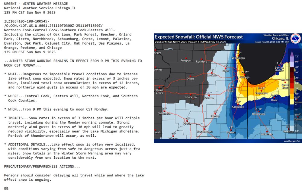
November 9/10: Rather exceptional snowfall forecast here in the greater Chicago metro region, including northwest Indiana. Very dangerous driving conditions given snowfall rates could be 3+ inches per hour (plus 30 mph winds). Locations just miles apart could see dramatically different snow totals.
November 10, 2025 at 1:18 AM
November 9/10: Rather exceptional snowfall forecast here in the greater Chicago metro region, including northwest Indiana. Very dangerous driving conditions given snowfall rates could be 3+ inches per hour (plus 30 mph winds). Locations just miles apart could see dramatically different snow totals.
November 6: #Fung-wong is very quickly organizing as it heads towards the Philippines. This could be a very powerful typhoon as it heads through the archipelago.
Parts of the Philippines are still in early stages of recovery following catastrophic flooding from #Kalmaegi.
Parts of the Philippines are still in early stages of recovery following catastrophic flooding from #Kalmaegi.
November 6, 2025 at 11:17 PM
November 6: #Fung-wong is very quickly organizing as it heads towards the Philippines. This could be a very powerful typhoon as it heads through the archipelago.
Parts of the Philippines are still in early stages of recovery following catastrophic flooding from #Kalmaegi.
Parts of the Philippines are still in early stages of recovery following catastrophic flooding from #Kalmaegi.
This doesn't get as much attention as it should, but the state of Texas has substantially increased its share of electricity sourcing from wind and solar.
Per ERCOT: Here's a look of its current generation mix by type for today (Nov 6) and its monthly capacity.
Change is happening. We need more.
Per ERCOT: Here's a look of its current generation mix by type for today (Nov 6) and its monthly capacity.
Change is happening. We need more.

November 6, 2025 at 6:12 PM
This doesn't get as much attention as it should, but the state of Texas has substantially increased its share of electricity sourcing from wind and solar.
Per ERCOT: Here's a look of its current generation mix by type for today (Nov 6) and its monthly capacity.
Change is happening. We need more.
Per ERCOT: Here's a look of its current generation mix by type for today (Nov 6) and its monthly capacity.
Change is happening. We need more.
Typhoon Kalmaegi headed to Vietnam after causing catastrophic flash flooding in the Philippines. Parts of Vietnam have dealt with exceptional flooding from storms since September. Those flood damage costs are estimated beyond $2.04 billion.
Yet another storm (Fung-wong) on deck for the Philippines.
Yet another storm (Fung-wong) on deck for the Philippines.
November 5, 2025 at 6:34 PM
Typhoon Kalmaegi headed to Vietnam after causing catastrophic flash flooding in the Philippines. Parts of Vietnam have dealt with exceptional flooding from storms since September. Those flood damage costs are estimated beyond $2.04 billion.
Yet another storm (Fung-wong) on deck for the Philippines.
Yet another storm (Fung-wong) on deck for the Philippines.
Important article on the incredibly complex and nearly impossible tightrope walk for the California insurance market with the wildfire peril.
One correction is needed. Traditional catastrophe models now allowed to be used for pricing are NOT climate change models.
www.nytimes.com/2025/11/01/u...
One correction is needed. Traditional catastrophe models now allowed to be used for pricing are NOT climate change models.
www.nytimes.com/2025/11/01/u...
November 2, 2025 at 3:14 PM
Important article on the incredibly complex and nearly impossible tightrope walk for the California insurance market with the wildfire peril.
One correction is needed. Traditional catastrophe models now allowed to be used for pricing are NOT climate change models.
www.nytimes.com/2025/11/01/u...
One correction is needed. Traditional catastrophe models now allowed to be used for pricing are NOT climate change models.
www.nytimes.com/2025/11/01/u...
Every Halloween, this is apparently the scariest thing in the neighborhood. Without fail, at least one person stops and asks if this 'thing' is invading people's privacy.
The look of bewilderment when it's revealed that this is a weather station never ceases to be hilarious. 😂
The look of bewilderment when it's revealed that this is a weather station never ceases to be hilarious. 😂

October 31, 2025 at 10:48 PM
Every Halloween, this is apparently the scariest thing in the neighborhood. Without fail, at least one person stops and asks if this 'thing' is invading people's privacy.
The look of bewilderment when it's revealed that this is a weather station never ceases to be hilarious. 😂
The look of bewilderment when it's revealed that this is a weather station never ceases to be hilarious. 😂
#Melissa: Jamaica will receive an insurance payment of $70.8mn from its policy through the Caribbean Catastrophe Risk Insurance Facility (CCRIF); a record for the program. Combined with the expected full $150mn payout from Jamaica's catastrophe bond, this will be important liquidity.
(1/2)
(1/2)

October 31, 2025 at 7:21 PM
#Melissa: Jamaica will receive an insurance payment of $70.8mn from its policy through the Caribbean Catastrophe Risk Insurance Facility (CCRIF); a record for the program. Combined with the expected full $150mn payout from Jamaica's catastrophe bond, this will be important liquidity.
(1/2)
(1/2)
ICYMI: Staggering rainfall in Vietnam in the past week. Bach Ma mountain near Hue City recorded a one-day rainfall of 1,740 mm (68.50 in). This is unofficially the second highest 24-hour rainfall ever recorded globally.
Record: 1,825 mm / 71.85 in La Réunion; January 7-8, 1966
(1/2)
Record: 1,825 mm / 71.85 in La Réunion; January 7-8, 1966
(1/2)

October 31, 2025 at 6:04 PM
ICYMI: Staggering rainfall in Vietnam in the past week. Bach Ma mountain near Hue City recorded a one-day rainfall of 1,740 mm (68.50 in). This is unofficially the second highest 24-hour rainfall ever recorded globally.
Record: 1,825 mm / 71.85 in La Réunion; January 7-8, 1966
(1/2)
Record: 1,825 mm / 71.85 in La Réunion; January 7-8, 1966
(1/2)
October 28 12:45pm ET: #Melissa in the process of coming ashore. Very concerned about Montego Bay getting into the eyewall. The whole island right now is taking the worst of what Melissa was going to bring: exceptional winds, blinding heavy rainfall, and extensive coastal storm surge.

October 28, 2025 at 4:49 PM
October 28 12:45pm ET: #Melissa in the process of coming ashore. Very concerned about Montego Bay getting into the eyewall. The whole island right now is taking the worst of what Melissa was going to bring: exceptional winds, blinding heavy rainfall, and extensive coastal storm surge.
#Melissa: It is not hyperbolic to say that parts of western and central Jamaica will be unrecognizable once the storm passes. This is one of the strongest known tropical cyclones to make landfall anywhere in the world.
And.
Yet another example of a strengthening storm up to the point of landfall.
And.
Yet another example of a strengthening storm up to the point of landfall.

October 28, 2025 at 2:22 PM
#Melissa: It is not hyperbolic to say that parts of western and central Jamaica will be unrecognizable once the storm passes. This is one of the strongest known tropical cyclones to make landfall anywhere in the world.
And.
Yet another example of a strengthening storm up to the point of landfall.
And.
Yet another example of a strengthening storm up to the point of landfall.
Updated #Melissa stats:
✓ 7th known Atlantic hurricane with sub-900 millibar intensity
✓ One of 10 known Atlantic hurricanes to reach at least 180 mph sustained winds (1-minute average)
✓ 2024 & 2025: First back-to-back Atlantic seasons with 180+ mph / <900mb hurricanes
✓ 7th known Atlantic hurricane with sub-900 millibar intensity
✓ One of 10 known Atlantic hurricanes to reach at least 180 mph sustained winds (1-minute average)
✓ 2024 & 2025: First back-to-back Atlantic seasons with 180+ mph / <900mb hurricanes

October 28, 2025 at 1:30 PM
Updated #Melissa stats:
✓ 7th known Atlantic hurricane with sub-900 millibar intensity
✓ One of 10 known Atlantic hurricanes to reach at least 180 mph sustained winds (1-minute average)
✓ 2024 & 2025: First back-to-back Atlantic seasons with 180+ mph / <900mb hurricanes
✓ 7th known Atlantic hurricane with sub-900 millibar intensity
✓ One of 10 known Atlantic hurricanes to reach at least 180 mph sustained winds (1-minute average)
✓ 2024 & 2025: First back-to-back Atlantic seasons with 180+ mph / <900mb hurricanes
October 28 9:00am ET: #Melissa is now a 180 mph storm with a central pressure down to 896 millibars.
Only 5 other known Atlantic storms have had stronger wind speeds (Allen, Dorian, Wilma, Gilbert, Labor Day (1935)).
2024 & 2025: First back-to-back years with <900mb Atlantic hurricanes on record.
Only 5 other known Atlantic storms have had stronger wind speeds (Allen, Dorian, Wilma, Gilbert, Labor Day (1935)).
2024 & 2025: First back-to-back years with <900mb Atlantic hurricanes on record.
October 28, 2025 at 1:14 PM
October 28 9:00am ET: #Melissa is now a 180 mph storm with a central pressure down to 896 millibars.
Only 5 other known Atlantic storms have had stronger wind speeds (Allen, Dorian, Wilma, Gilbert, Labor Day (1935)).
2024 & 2025: First back-to-back years with <900mb Atlantic hurricanes on record.
Only 5 other known Atlantic storms have had stronger wind speeds (Allen, Dorian, Wilma, Gilbert, Labor Day (1935)).
2024 & 2025: First back-to-back years with <900mb Atlantic hurricanes on record.
"Mind the wind, fear the water." The level of rain falling in Jamaica will drive catastrophic flooding across many parts of the island. Nearly a years' worth of rain may fall in a matter of days. Parts of Hispaniola and Cuba also faces a major flood threat. The graphic shows rain yet to come.
(3/n)
(3/n)

October 28, 2025 at 12:17 PM
"Mind the wind, fear the water." The level of rain falling in Jamaica will drive catastrophic flooding across many parts of the island. Nearly a years' worth of rain may fall in a matter of days. Parts of Hispaniola and Cuba also faces a major flood threat. The graphic shows rain yet to come.
(3/n)
(3/n)
While the entire island of Jamaica will be affected, the most extreme winds will only be felt within a few miles from the landfall point. Kingston will escape the worst winds. However, given the mountainous terrain, communities with elevation will endure very dangerous / intense gusts.
(2/n)
(2/n)

October 28, 2025 at 12:17 PM
While the entire island of Jamaica will be affected, the most extreme winds will only be felt within a few miles from the landfall point. Kingston will escape the worst winds. However, given the mountainous terrain, communities with elevation will endure very dangerous / intense gusts.
(2/n)
(2/n)
October 28 8am ET: #Melissa making final approach towards Jamaica. The situation remains extremely serious for Jamaica. Parts of Hispaniola, Cuba, and the Bahamas are all facing impacts from this storm, too.
A short thread upcoming...
(1/n)
A short thread upcoming...
(1/n)
October 28, 2025 at 12:17 PM
October 28 8am ET: #Melissa making final approach towards Jamaica. The situation remains extremely serious for Jamaica. Parts of Hispaniola, Cuba, and the Bahamas are all facing impacts from this storm, too.
A short thread upcoming...
(1/n)
A short thread upcoming...
(1/n)
A 2017 paper reassessed the history of the Advanced Dvorak Technique (ADT) for global storms since 1979. As of 10:30pm ET on October 27, #Melissa is now *unofficially* only behind 2015's Hurricane Patricia (Eastern Pacific) for highest ADT in the past 46 years.
journals.ametsoc.org/view/journal...
journals.ametsoc.org/view/journal...

October 28, 2025 at 2:38 AM
A 2017 paper reassessed the history of the Advanced Dvorak Technique (ADT) for global storms since 1979. As of 10:30pm ET on October 27, #Melissa is now *unofficially* only behind 2015's Hurricane Patricia (Eastern Pacific) for highest ADT in the past 46 years.
journals.ametsoc.org/view/journal...
journals.ametsoc.org/view/journal...
What we're witnessing with #Melissa is ultra rare in the history of known hurricanes in the Atlantic. This level of sustained intensity and feasting on every joule of ocean heat content without any real disruption is incredible.
Not hyperbole: Jamaica is facing a generational catastrophic event.
Not hyperbole: Jamaica is facing a generational catastrophic event.
October 28, 2025 at 2:23 AM
What we're witnessing with #Melissa is ultra rare in the history of known hurricanes in the Atlantic. This level of sustained intensity and feasting on every joule of ocean heat content without any real disruption is incredible.
Not hyperbole: Jamaica is facing a generational catastrophic event.
Not hyperbole: Jamaica is facing a generational catastrophic event.
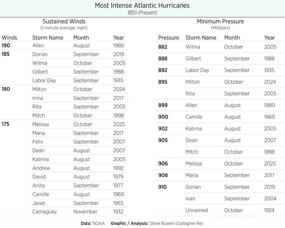
October 27 PM: Here is the updated Atlantic record book for most intense hurricanes in NOAA's official dataset going back to 1851. Melissa has rocketed up the list(s).
In the past 72 hours, Melissa has seen:
- Sustained winds increase by 100 knots (115 mph)
- Minimum pressure drop by 91 millibars
In the past 72 hours, Melissa has seen:
- Sustained winds increase by 100 knots (115 mph)
- Minimum pressure drop by 91 millibars
October 27, 2025 at 7:44 PM
October 27 PM: Here is the updated Atlantic record book for most intense hurricanes in NOAA's official dataset going back to 1851. Melissa has rocketed up the list(s).
In the past 72 hours, Melissa has seen:
- Sustained winds increase by 100 knots (115 mph)
- Minimum pressure drop by 91 millibars
In the past 72 hours, Melissa has seen:
- Sustained winds increase by 100 knots (115 mph)
- Minimum pressure drop by 91 millibars
October 27 11am ET: The current minimum central pressure of #Melissa is down to 908 millibars. This is the lowest MSLP in the Atlantic at such a late date in calendar year on record; surpassing Mitch (Oct 27, 1999) at 910 millibars.

October 27, 2025 at 3:38 PM
October 27 11am ET: The current minimum central pressure of #Melissa is down to 908 millibars. This is the lowest MSLP in the Atlantic at such a late date in calendar year on record; surpassing Mitch (Oct 27, 1999) at 910 millibars.
#Melissa: Thru October 26, the 2025 season has now had 18 "episodes" in a 24-hour span which met the RI definition.
There have now been 10 "episodes" in 2025 which have seen >50 knot RI.
Only 2020 and 2005 (11) have recorded more in either the Satellite Era (1966-) or the full NHC record (1851-).
There have now been 10 "episodes" in 2025 which have seen >50 knot RI.
Only 2020 and 2005 (11) have recorded more in either the Satellite Era (1966-) or the full NHC record (1851-).

October 26, 2025 at 9:41 PM
#Melissa: Thru October 26, the 2025 season has now had 18 "episodes" in a 24-hour span which met the RI definition.
There have now been 10 "episodes" in 2025 which have seen >50 knot RI.
Only 2020 and 2005 (11) have recorded more in either the Satellite Era (1966-) or the full NHC record (1851-).
There have now been 10 "episodes" in 2025 which have seen >50 knot RI.
Only 2020 and 2005 (11) have recorded more in either the Satellite Era (1966-) or the full NHC record (1851-).
#Melissa: 2025's fourth Atlantic storm to meet the definition of rapid intensification (RI); strengthen by 30 knots (35 mph) in a 24-hr period.
Each 2025 Atlantic major hurricane has seen explosive >50 knot (60 mph) strengthening in 24 hrs.
Only 2025, 2020, 2008, and 2005 have achieved this feat.
Each 2025 Atlantic major hurricane has seen explosive >50 knot (60 mph) strengthening in 24 hrs.
Only 2025, 2020, 2008, and 2005 have achieved this feat.

October 26, 2025 at 9:41 PM
#Melissa: 2025's fourth Atlantic storm to meet the definition of rapid intensification (RI); strengthen by 30 knots (35 mph) in a 24-hr period.
Each 2025 Atlantic major hurricane has seen explosive >50 knot (60 mph) strengthening in 24 hrs.
Only 2025, 2020, 2008, and 2005 have achieved this feat.
Each 2025 Atlantic major hurricane has seen explosive >50 knot (60 mph) strengthening in 24 hrs.
Only 2025, 2020, 2008, and 2005 have achieved this feat.
October 26 5pm ET: #Melissa, unfortunately, has never looked better on satellite. The NHC indicates Melissa is now up to 145 mph winds (Category 4). We'll see if this goes Category 5 in the next 24-48 hours.
High potential for catastrophic impacts in Jamaica, Cuba, and Hispaniola. Heartbreaking.
High potential for catastrophic impacts in Jamaica, Cuba, and Hispaniola. Heartbreaking.
October 26, 2025 at 9:15 PM
October 26 5pm ET: #Melissa, unfortunately, has never looked better on satellite. The NHC indicates Melissa is now up to 145 mph winds (Category 4). We'll see if this goes Category 5 in the next 24-48 hours.
High potential for catastrophic impacts in Jamaica, Cuba, and Hispaniola. Heartbreaking.
High potential for catastrophic impacts in Jamaica, Cuba, and Hispaniola. Heartbreaking.
October 24: The potential risk to life and property in Jamaica, Cuba, and Hispaniola from #Melissa is enormous.
While predicted damage costs may not mirror a landfalling Cat 3/4/5 US mainland event, the societal implications could be catastrophic and long-term for many communities in the Caribbean.
While predicted damage costs may not mirror a landfalling Cat 3/4/5 US mainland event, the societal implications could be catastrophic and long-term for many communities in the Caribbean.
October 24, 2025 at 5:53 PM
October 24: The potential risk to life and property in Jamaica, Cuba, and Hispaniola from #Melissa is enormous.
While predicted damage costs may not mirror a landfalling Cat 3/4/5 US mainland event, the societal implications could be catastrophic and long-term for many communities in the Caribbean.
While predicted damage costs may not mirror a landfalling Cat 3/4/5 US mainland event, the societal implications could be catastrophic and long-term for many communities in the Caribbean.
Should the forecasts for #Melissa verify, it will become the next Category 4+ tropical cyclone for the globe. Longer-range trends show a higher frequency of total storms reaching the Cat 4/5 equivalent threshold. Roughly 40% of hurricane-equivalent global storms now obtain Cat 4/5 strength.

October 23, 2025 at 7:44 PM
Should the forecasts for #Melissa verify, it will become the next Category 4+ tropical cyclone for the globe. Longer-range trends show a higher frequency of total storms reaching the Cat 4/5 equivalent threshold. Roughly 40% of hurricane-equivalent global storms now obtain Cat 4/5 strength.