


Andrew Pritchard
@skydrama.bsky.social
Focused on Disruptive Weather | Award Winning Weather Risk Communicator | Observer of Severe Storms in the American Midwest ⛈️🌪️💨
SKYDRAMA.NET
SKYDRAMA.NET
Open season for Arctic outbreaks from the Canadian Prairies into the Midwest/Great Lakes as this pattern just continues to reload with cold air through the middle of December.
December 3, 2025 at 2:37 PM
Open season for Arctic outbreaks from the Canadian Prairies into the Midwest/Great Lakes as this pattern just continues to reload with cold air through the middle of December.
My big year-end storm chasing flick premieres on at 7:15 PM CT this evening! I'll share a YouTube link when it's available but wanted to put it on your radar if you're not traveling and want to join me for the live premier!

November 26, 2025 at 4:59 PM
My big year-end storm chasing flick premieres on at 7:15 PM CT this evening! I'll share a YouTube link when it's available but wanted to put it on your radar if you're not traveling and want to join me for the live premier!
I wouldn't discount a strong tornado or two across east Texas or western Louisiana between 5 PM - 10 PM this evening.
If storms don't get too messy too early, late evening shear profiles are pretty impressive and could support sustained supercells and damaging tornado risk.
If storms don't get too messy too early, late evening shear profiles are pretty impressive and could support sustained supercells and damaging tornado risk.
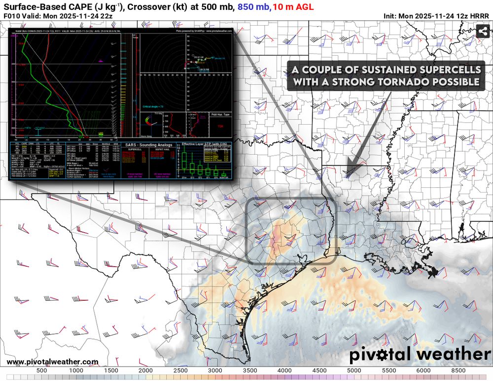
November 24, 2025 at 3:44 PM
I wouldn't discount a strong tornado or two across east Texas or western Louisiana between 5 PM - 10 PM this evening.
If storms don't get too messy too early, late evening shear profiles are pretty impressive and could support sustained supercells and damaging tornado risk.
If storms don't get too messy too early, late evening shear profiles are pretty impressive and could support sustained supercells and damaging tornado risk.
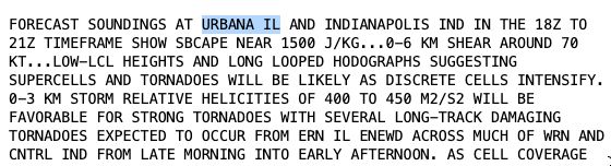
A little under .30” in my Urbana, IL backyard from overnight rain.
We could see a little more through mid-day, but this is probably about it until Thu/Fri. We’ll take it.
We could see a little more through mid-day, but this is probably about it until Thu/Fri. We’ll take it.

November 18, 2025 at 3:27 PM
A little under .30” in my Urbana, IL backyard from overnight rain.
We could see a little more through mid-day, but this is probably about it until Thu/Fri. We’ll take it.
We could see a little more through mid-day, but this is probably about it until Thu/Fri. We’ll take it.
November 17th, 2013 was a top 3 scary weather day locally. My hometown (Urbana) was called out in the day one severe weather outlook from the SPC, and I found myself pacing the kitchen with anxiety that morning.
Damaging tornadoes split Champaign-Urbana north and south of town.
Damaging tornadoes split Champaign-Urbana north and south of town.


November 17, 2025 at 4:40 PM
November 17th, 2013 was a top 3 scary weather day locally. My hometown (Urbana) was called out in the day one severe weather outlook from the SPC, and I found myself pacing the kitchen with anxiety that morning.
Damaging tornadoes split Champaign-Urbana north and south of town.
Damaging tornadoes split Champaign-Urbana north and south of town.
Thanks to a persistent continental ridge across western/central North America there's a lot of warm & dry on the map as we look at November temperatures and precipitation so far.
Top 10 warmest November so far west of the Rockies, much of the Lower 48 off to a very dry start.
Top 10 warmest November so far west of the Rockies, much of the Lower 48 off to a very dry start.


November 17, 2025 at 3:24 PM
Thanks to a persistent continental ridge across western/central North America there's a lot of warm & dry on the map as we look at November temperatures and precipitation so far.
Top 10 warmest November so far west of the Rockies, much of the Lower 48 off to a very dry start.
Top 10 warmest November so far west of the Rockies, much of the Lower 48 off to a very dry start.
We haven't seen a trough west / ridge east pattern establish itself across the U.S. since the early spring months in 2025!
Likely looking at a run of high-impact storm systems and some desperately needed heavy rainfall from the Southern Plains to the Ohio Valley next week.
Likely looking at a run of high-impact storm systems and some desperately needed heavy rainfall from the Southern Plains to the Ohio Valley next week.


November 13, 2025 at 5:17 PM
We haven't seen a trough west / ridge east pattern establish itself across the U.S. since the early spring months in 2025!
Likely looking at a run of high-impact storm systems and some desperately needed heavy rainfall from the Southern Plains to the Ohio Valley next week.
Likely looking at a run of high-impact storm systems and some desperately needed heavy rainfall from the Southern Plains to the Ohio Valley next week.
Lots of chatter about a potentially cold & wintry December, but on the way there we may be looking at a pattern supporting of one or more organized severe weather events from the Southern Plains into the Ohio Valley and Gulf Coast focused ~ Nov 18-24, shifting cold after?


November 12, 2025 at 9:49 PM
Lots of chatter about a potentially cold & wintry December, but on the way there we may be looking at a pattern supporting of one or more organized severe weather events from the Southern Plains into the Ohio Valley and Gulf Coast focused ~ Nov 18-24, shifting cold after?
What a fun night! I always know there are top tier photographers out there capturing the “photos of the night” so I ventured out to my usual spot, a quiet little tire track road north of town and enjoyed the show with some peace and quiet. Champaign County, Illinois between 8-10 PM CT.
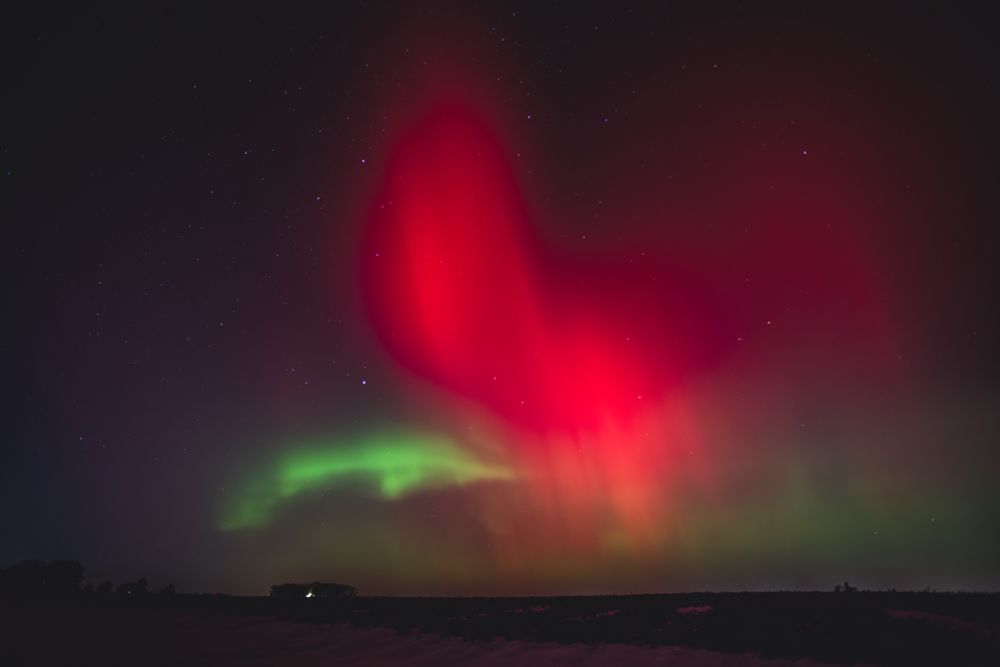


November 12, 2025 at 12:31 PM
What a fun night! I always know there are top tier photographers out there capturing the “photos of the night” so I ventured out to my usual spot, a quiet little tire track road north of town and enjoyed the show with some peace and quiet. Champaign County, Illinois between 8-10 PM CT.
Snow depth on Tuesday morning follow the first big lake-effect snow event of the season across the Great Lakes. A lot of this will be melting over the next few days as warmer temperatures build back into the region.

November 11, 2025 at 4:01 PM
Snow depth on Tuesday morning follow the first big lake-effect snow event of the season across the Great Lakes. A lot of this will be melting over the next few days as warmer temperatures build back into the region.
It's the wonder of nature, baby! SKYDRAMA 2025 is coming.
My annual year-end storm chasing flick promises to be one of my longest winded ever, packed with supercells and tornadoes from the Great Plains to the Midwest.
Wednesday night before Thanksgiving release, Nov 26!
My annual year-end storm chasing flick promises to be one of my longest winded ever, packed with supercells and tornadoes from the Great Plains to the Midwest.
Wednesday night before Thanksgiving release, Nov 26!

November 11, 2025 at 2:28 PM
It's the wonder of nature, baby! SKYDRAMA 2025 is coming.
My annual year-end storm chasing flick promises to be one of my longest winded ever, packed with supercells and tornadoes from the Great Plains to the Midwest.
Wednesday night before Thanksgiving release, Nov 26!
My annual year-end storm chasing flick promises to be one of my longest winded ever, packed with supercells and tornadoes from the Great Plains to the Midwest.
Wednesday night before Thanksgiving release, Nov 26!
Here's another aerial shot from Urbana, IL looking southeast toward Sidney in the distance. Looks like visibility is improving across Champaign County this morning, but you can still tell it's blowing around in rural areas which may keep rural roadways slick through mid-day.

November 10, 2025 at 3:04 PM
Here's another aerial shot from Urbana, IL looking southeast toward Sidney in the distance. Looks like visibility is improving across Champaign County this morning, but you can still tell it's blowing around in rural areas which may keep rural roadways slick through mid-day.
Champaign-Urbana and the University of Illinois campus look beautiful this morning with a fresh coating of snow and our brilliant autumn color palette. Looks great from above, but roads are problematic across Champaign County so stay home and enjoy from the window if you're able.

November 10, 2025 at 3:02 PM
Champaign-Urbana and the University of Illinois campus look beautiful this morning with a fresh coating of snow and our brilliant autumn color palette. Looks great from above, but roads are problematic across Champaign County so stay home and enjoy from the window if you're able.
Snow flurries continue in Champaign-Urbana early Sunday night. We may see a lake-effect boost ramp us up to some blustery snow that gives some of us a dusting up to an inch along Interstate 57 north from Champaign to Kankakee early Monday morning.
November 10, 2025 at 1:56 AM
Snow flurries continue in Champaign-Urbana early Sunday night. We may see a lake-effect boost ramp us up to some blustery snow that gives some of us a dusting up to an inch along Interstate 57 north from Champaign to Kankakee early Monday morning.
Appropriately strong wording from @NWSChicago AFD regarding the potential for multiple intense bands of lake effect snow tonight into Monday morning.
Extremely heavy snow with zero visibility, high winds, and lightning possible in the strongest bands.
Extremely heavy snow with zero visibility, high winds, and lightning possible in the strongest bands.


November 9, 2025 at 3:43 PM
Appropriately strong wording from @NWSChicago AFD regarding the potential for multiple intense bands of lake effect snow tonight into Monday morning.
Extremely heavy snow with zero visibility, high winds, and lightning possible in the strongest bands.
Extremely heavy snow with zero visibility, high winds, and lightning possible in the strongest bands.
First snowflakes of the season in Champaign-Urbana, #ilwx thanks to a band of lake effect snow extending south-southwest off of Lake Michigan this morning. Heavy snow, winter storm warnings in northeast Illinois and northwest Indiana with blustery flurries extending down I-57.

November 9, 2025 at 2:09 PM
First snowflakes of the season in Champaign-Urbana, #ilwx thanks to a band of lake effect snow extending south-southwest off of Lake Michigan this morning. Heavy snow, winter storm warnings in northeast Illinois and northwest Indiana with blustery flurries extending down I-57.
Tomorrow (Wed, Nov 5) - a risk for low-topped supercells and tornadoes along the Pacific Coast of Washington and Oregon, and thunderless windy severe storms in Pennsylvania and New York.
Just some classic U.S. severe storms.
Just some classic U.S. severe storms.


November 4, 2025 at 6:19 PM
Tomorrow (Wed, Nov 5) - a risk for low-topped supercells and tornadoes along the Pacific Coast of Washington and Oregon, and thunderless windy severe storms in Pennsylvania and New York.
Just some classic U.S. severe storms.
Just some classic U.S. severe storms.
10 out of 10 November day in central Illinois.

November 4, 2025 at 5:21 PM
10 out of 10 November day in central Illinois.
Clippers running along the US/Canada border will deliver some light moisture to parts of the Great Lakes/Ohio Valley that desperately need it late this week, but totals will be light.
Better moisture chances/stormy pattern ideas gaining traction in week 2, Nov 12-19.
Better moisture chances/stormy pattern ideas gaining traction in week 2, Nov 12-19.


November 4, 2025 at 3:16 PM
Clippers running along the US/Canada border will deliver some light moisture to parts of the Great Lakes/Ohio Valley that desperately need it late this week, but totals will be light.
Better moisture chances/stormy pattern ideas gaining traction in week 2, Nov 12-19.
Better moisture chances/stormy pattern ideas gaining traction in week 2, Nov 12-19.
October 2025 temperature and precipitation ranks by climate division.
Top 15 warmest on record for much of the Central U.S.
Mix of wetter/drier corridors with widespread, expanding fall drought generally persisting.
Top 15 warmest on record for much of the Central U.S.
Mix of wetter/drier corridors with widespread, expanding fall drought generally persisting.


November 3, 2025 at 3:07 PM
October 2025 temperature and precipitation ranks by climate division.
Top 15 warmest on record for much of the Central U.S.
Mix of wetter/drier corridors with widespread, expanding fall drought generally persisting.
Top 15 warmest on record for much of the Central U.S.
Mix of wetter/drier corridors with widespread, expanding fall drought generally persisting.
Aggressive, shallow (short!) convection over Champaign-Urbana, #ilwx this evening. Crisp updrafts and mammatus but barely a blip on radar.
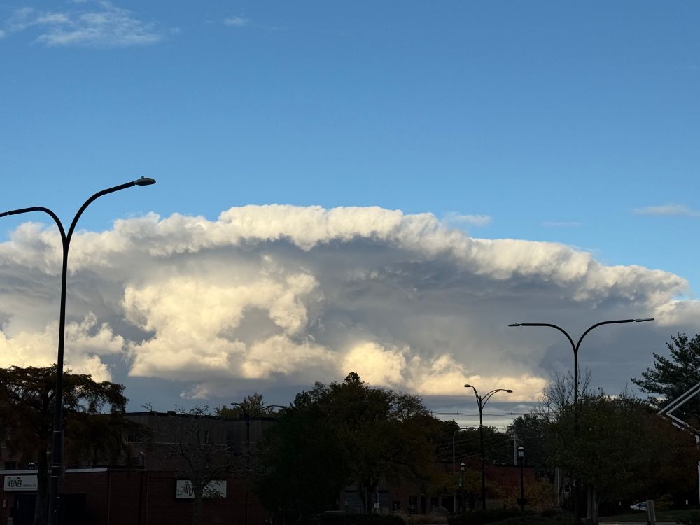


November 1, 2025 at 10:10 PM
Aggressive, shallow (short!) convection over Champaign-Urbana, #ilwx this evening. Crisp updrafts and mammatus but barely a blip on radar.
Jamaica is about to experience a catastrophic weather event as Category 5 Hurricane Melissa approaches as one of the strongest landfalling Atlantic hurricanes in recorded history.


October 28, 2025 at 1:27 PM
Jamaica is about to experience a catastrophic weather event as Category 5 Hurricane Melissa approaches as one of the strongest landfalling Atlantic hurricanes in recorded history.
Slight risk (level 2 of 5) for severe storms along the Gulf Coast from the Texas coastal plains into southern Louisiana and far southwest Mississippi.
Messy storm mode expected w/ a couple of intense storms producing tornadoes, damaging winds, hail, heavy rain through the day.
Messy storm mode expected w/ a couple of intense storms producing tornadoes, damaging winds, hail, heavy rain through the day.


October 25, 2025 at 1:17 PM
Slight risk (level 2 of 5) for severe storms along the Gulf Coast from the Texas coastal plains into southern Louisiana and far southwest Mississippi.
Messy storm mode expected w/ a couple of intense storms producing tornadoes, damaging winds, hail, heavy rain through the day.
Messy storm mode expected w/ a couple of intense storms producing tornadoes, damaging winds, hail, heavy rain through the day.
The growing season will come to an end tonight across a big portion of the Midwest & Ohio Valley. Freeze Warnings are in effect from Wisconsin to Kentucky with overnight lows expected to settle around 30 deg F in most area, though some will fall into the 20s! 🧊


October 23, 2025 at 4:08 PM
The growing season will come to an end tonight across a big portion of the Midwest & Ohio Valley. Freeze Warnings are in effect from Wisconsin to Kentucky with overnight lows expected to settle around 30 deg F in most area, though some will fall into the 20s! 🧊
October will come to a WINDY conclusion next week with multiple deep areas of low pressure expected to bring high winds from the Pacific Northwest into the Central and Eastern U.S.
CPC highlights widespread areas of high wind potential Oct 29 - Nov 4, + GFS forecast max winds:
CPC highlights widespread areas of high wind potential Oct 29 - Nov 4, + GFS forecast max winds:


October 22, 2025 at 3:07 PM
October will come to a WINDY conclusion next week with multiple deep areas of low pressure expected to bring high winds from the Pacific Northwest into the Central and Eastern U.S.
CPC highlights widespread areas of high wind potential Oct 29 - Nov 4, + GFS forecast max winds:
CPC highlights widespread areas of high wind potential Oct 29 - Nov 4, + GFS forecast max winds: