


Shane Wilson
@shanew147.bsky.social
Part-time Genealogist, I.T. Consultant, ex Bass player - Dublin, Ireland - other interests : Science, Maps, Photography, Astronomy, History, Archaeology, Computers &c
web: https://swilson.info
also mastadon.ie same username
web: https://swilson.info
also mastadon.ie same username


Old Catholic Chapel at former Rathdown Workhouse County #Dublin - now the location of St. Columcille's Hospital, stone from the old entrance 1841, and views of the graveyard


November 2, 2025 at 6:29 PM
Old Catholic Chapel at former Rathdown Workhouse County #Dublin - now the location of St. Columcille's Hospital, stone from the old entrance 1841, and views of the graveyard


August 2, 2025 at 6:07 PM
Reposted by Shane Wilson

IGRS Top Research Tip #163: The latest edition (July 2025) of the List of Church of Ireland Parish Registers includes hyperlinks to detailed lists of the many collections of parish records now held by the RCB Library: shorturl.at/B7wXC
July 12, 2025 at 7:31 AM
IGRS Top Research Tip #163: The latest edition (July 2025) of the List of Church of Ireland Parish Registers includes hyperlinks to detailed lists of the many collections of parish records now held by the RCB Library: shorturl.at/B7wXC
Nice colour version of Environs of #Dublin #Map 1837, drawn by B.R. Davies for #SDUK (Society for the Diffusion of Useful Knowledge), from Boston Public Library / Norman B. Leventhal Map & Education Center
For a b&w version see : www.swilson.info/maps/CoDubli...
For a b&w version see : www.swilson.info/maps/CoDubli...


July 7, 2025 at 12:40 PM
Nice colour version of Environs of #Dublin #Map 1837, drawn by B.R. Davies for #SDUK (Society for the Diffusion of Useful Knowledge), from Boston Public Library / Norman B. Leventhal Map & Education Center
For a b&w version see : www.swilson.info/maps/CoDubli...
For a b&w version see : www.swilson.info/maps/CoDubli...


July 1, 2025 at 6:44 PM

June 11, 2025 at 3:12 PM

Some of my photos from a visit a few years ago to Dunamase #Castle Co. Laois.. #Ireland #Photography
(approx location on c1867 map - Blackie / Weller-Swilson.info)
(approx location on c1867 map - Blackie / Weller-Swilson.info)


May 21, 2025 at 7:12 PM
Some of my photos from a visit a few years ago to Dunamase #Castle Co. Laois.. #Ireland #Photography
(approx location on c1867 map - Blackie / Weller-Swilson.info)
(approx location on c1867 map - Blackie / Weller-Swilson.info)
Some updates on the Tithe Location Cross reference database - ongoing quest to try a fixed up the many location errors, also mapped out a few further CofI Churches and parishes
#Ireland #IrishGenealogy #FamilyHistory
www.swilson.info/tithelocxref...
www.swilson.info/cofiparishli...
#Ireland #IrishGenealogy #FamilyHistory
www.swilson.info/tithelocxref...
www.swilson.info/cofiparishli...


May 19, 2025 at 7:56 PM
Some updates on the Tithe Location Cross reference database - ongoing quest to try a fixed up the many location errors, also mapped out a few further CofI Churches and parishes
#Ireland #IrishGenealogy #FamilyHistory
www.swilson.info/tithelocxref...
www.swilson.info/cofiparishli...
#Ireland #IrishGenealogy #FamilyHistory
www.swilson.info/tithelocxref...
www.swilson.info/cofiparishli...
Reposted by Shane Wilson

Kilnasaggart Pillar Stone • Armagh
The stone marks a small early Christian burial ground, close to the route of the Slige Midlúachra, one of the great roads of ancient Ireland.
The stone marks a small early Christian burial ground, close to the route of the Slige Midlúachra, one of the great roads of ancient Ireland.

May 18, 2025 at 6:35 PM
Kilnasaggart Pillar Stone • Armagh
The stone marks a small early Christian burial ground, close to the route of the Slige Midlúachra, one of the great roads of ancient Ireland.
The stone marks a small early Christian burial ground, close to the route of the Slige Midlúachra, one of the great roads of ancient Ireland.


May 19, 2025 at 7:45 PM

May 19, 2025 at 7:42 PM
Reposted by Shane Wilson

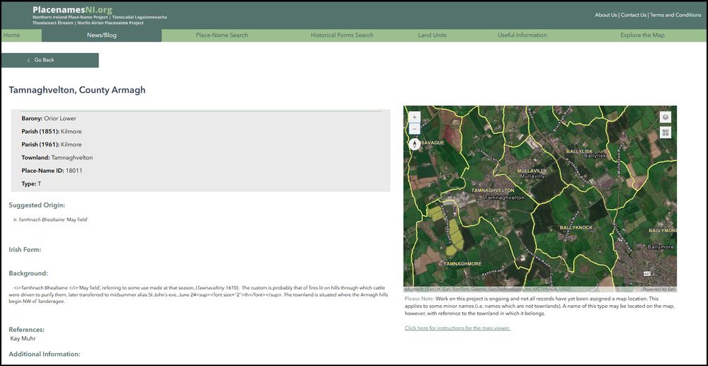
Lá Bealtaine / Mayday
logainm.ie/ga/teamai/45
Tamhnaigh Bhealtaine in Ard Mhacha
Tamnaghvelton Armagh
logainm.ie/ga/1417840
'tamhnach' = Grassy upland; arable place in mountain.
'the arable place, grassy upland of May'
Féach chomh maith 'http://PlacenamesNI.org'
logainm.ie/ga/teamai/45
Tamhnaigh Bhealtaine in Ard Mhacha
Tamnaghvelton Armagh
logainm.ie/ga/1417840
'tamhnach' = Grassy upland; arable place in mountain.
'the arable place, grassy upland of May'
Féach chomh maith 'http://PlacenamesNI.org'
May 1, 2025 at 10:28 AM
Lá Bealtaine / Mayday
logainm.ie/ga/teamai/45
Tamhnaigh Bhealtaine in Ard Mhacha
Tamnaghvelton Armagh
logainm.ie/ga/1417840
'tamhnach' = Grassy upland; arable place in mountain.
'the arable place, grassy upland of May'
Féach chomh maith 'http://PlacenamesNI.org'
logainm.ie/ga/teamai/45
Tamhnaigh Bhealtaine in Ard Mhacha
Tamnaghvelton Armagh
logainm.ie/ga/1417840
'tamhnach' = Grassy upland; arable place in mountain.
'the arable place, grassy upland of May'
Féach chomh maith 'http://PlacenamesNI.org'

April 27, 2025 at 12:45 PM
Some random #photos from today's walk in Co. #Dublin
Waldemar Terrace Dundrum
Dublin Landmark - Poolbeg chimneys
Merrion/Pembroke badge on old Gatelodge for Fitzwilliam estate at Mount Merrion
Two working post boxes Victorian and Saorstát Éireann (Irish Free State), less than 500 meters apart
Waldemar Terrace Dundrum
Dublin Landmark - Poolbeg chimneys
Merrion/Pembroke badge on old Gatelodge for Fitzwilliam estate at Mount Merrion
Two working post boxes Victorian and Saorstát Éireann (Irish Free State), less than 500 meters apart


April 14, 2025 at 4:28 PM
Updated the historic Irish map links article on my website - and added - browsable 1953 Dublin city & county map (University of Wisconsin), maps from National Library of Scotland, Taylor's 1816 Dublin Environs (McMaster University). etc... : www.swilson.info/wp/?p=1995


April 14, 2025 at 2:07 PM
Updated the historic Irish map links article on my website - and added - browsable 1953 Dublin city & county map (University of Wisconsin), maps from National Library of Scotland, Taylor's 1816 Dublin Environs (McMaster University). etc... : www.swilson.info/wp/?p=1995
#ParkRun (really #ParkBriskWalk) no. 2 at Marley Park Co. Dublin

April 12, 2025 at 5:47 PM
#ParkRun (really #ParkBriskWalk) no. 2 at Marley Park Co. Dublin
Reposted by Shane Wilson
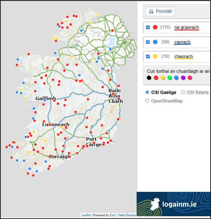
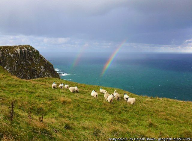
Faill na gCaorach i gCiarraí
Foilnageragh Kerry
logainm.ie/ga/1394397
'faill' nó 'aill / aillte' = cliff or cliffs
'caora' = sheep, ewe
'the cliff of the sheep (pl.)' 🐑🐏🐑
"An Chaoraíocht" i Loch Garman chomh maith.
'the (place of) shepherding'
logainm.ie/en/52155
Foilnageragh Kerry
logainm.ie/ga/1394397
'faill' nó 'aill / aillte' = cliff or cliffs
'caora' = sheep, ewe
'the cliff of the sheep (pl.)' 🐑🐏🐑
"An Chaoraíocht" i Loch Garman chomh maith.
'the (place of) shepherding'
logainm.ie/en/52155
March 27, 2025 at 10:13 AM
Faill na gCaorach i gCiarraí
Foilnageragh Kerry
logainm.ie/ga/1394397
'faill' nó 'aill / aillte' = cliff or cliffs
'caora' = sheep, ewe
'the cliff of the sheep (pl.)' 🐑🐏🐑
"An Chaoraíocht" i Loch Garman chomh maith.
'the (place of) shepherding'
logainm.ie/en/52155
Foilnageragh Kerry
logainm.ie/ga/1394397
'faill' nó 'aill / aillte' = cliff or cliffs
'caora' = sheep, ewe
'the cliff of the sheep (pl.)' 🐑🐏🐑
"An Chaoraíocht" i Loch Garman chomh maith.
'the (place of) shepherding'
logainm.ie/en/52155


March 22, 2025 at 11:05 AM
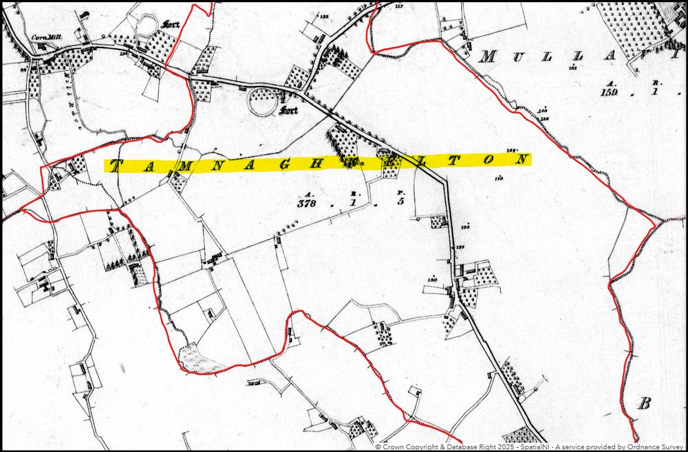
Some photos from walk last weekend - around Dundrum Co. #Dublin
1. Old Harcourt Railway Line - now Luas light rail
2. Campfield Terrace
3. Old School House
Map extract c1890-1910 from OSI/Geohive
1. Old Harcourt Railway Line - now Luas light rail
2. Campfield Terrace
3. Old School House
Map extract c1890-1910 from OSI/Geohive


March 20, 2025 at 7:39 PM
Some photos from walk last weekend - around Dundrum Co. #Dublin
1. Old Harcourt Railway Line - now Luas light rail
2. Campfield Terrace
3. Old School House
Map extract c1890-1910 from OSI/Geohive
1. Old Harcourt Railway Line - now Luas light rail
2. Campfield Terrace
3. Old School House
Map extract c1890-1910 from OSI/Geohive
