


Segregation by Design
@segbydesign.bsky.social
Using data and remastered historic photography to document the destruction of communities of color by redlining, urban renewal, freeways, and disinvestment; also highlighting solutions https://www.segregationbydesign.com/
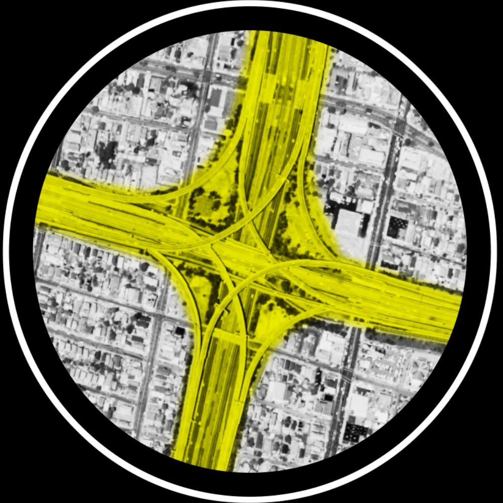
Latest updates on “Reconnecting Communities” news, arrayed along two axes: one comparing progress towards reconnection vs. the opposite; and another transformative change (for better or worse) vs. incremental. More info and links: www.segregationbydesign.com/reconnection...

November 2, 2025 at 6:19 PM
Latest updates on “Reconnecting Communities” news, arrayed along two axes: one comparing progress towards reconnection vs. the opposite; and another transformative change (for better or worse) vs. incremental. More info and links: www.segregationbydesign.com/reconnection...
Overview of mid-October “Reconnecting Communities” news, arrayed along two axes: one comparing progress towards reconnection vs. the opposite; and another transformative change (for better or worse) vs. incremental. More info and links: www.segregationbydesign.com/reconnection...

October 13, 2025 at 1:26 PM
Overview of mid-October “Reconnecting Communities” news, arrayed along two axes: one comparing progress towards reconnection vs. the opposite; and another transformative change (for better or worse) vs. incremental. More info and links: www.segregationbydesign.com/reconnection...
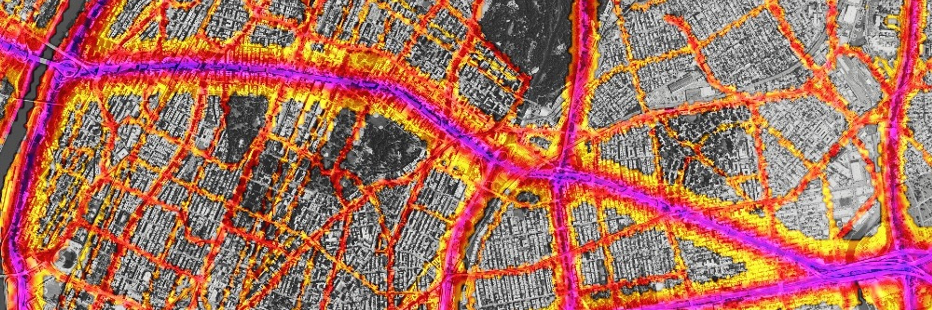
Overview of September “Reconnecting Communities” news, arrayed along two axes: one comparing progress towards reconnection vs. the opposite; and another transformative change (for better or worse) vs. more status quo developments. More info and links: www.segregationbydesign.com/reconnection...

October 6, 2025 at 11:43 AM
Overview of September “Reconnecting Communities” news, arrayed along two axes: one comparing progress towards reconnection vs. the opposite; and another transformative change (for better or worse) vs. more status quo developments. More info and links: www.segregationbydesign.com/reconnection...
According to official sources, highway construction and “urban renewal” in Detroit displaced roughly 43,000 people during the 1950s/60s. Historians estimate the number to be far higher—closer to 100,000. More info: www.segregationbydesign.com/detroit/i75375
June 5, 2025 at 3:57 PM
According to official sources, highway construction and “urban renewal” in Detroit displaced roughly 43,000 people during the 1950s/60s. Historians estimate the number to be far higher—closer to 100,000. More info: www.segregationbydesign.com/detroit/i75375
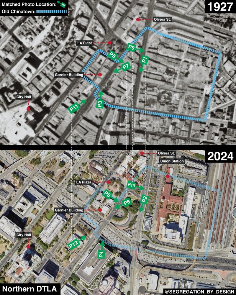
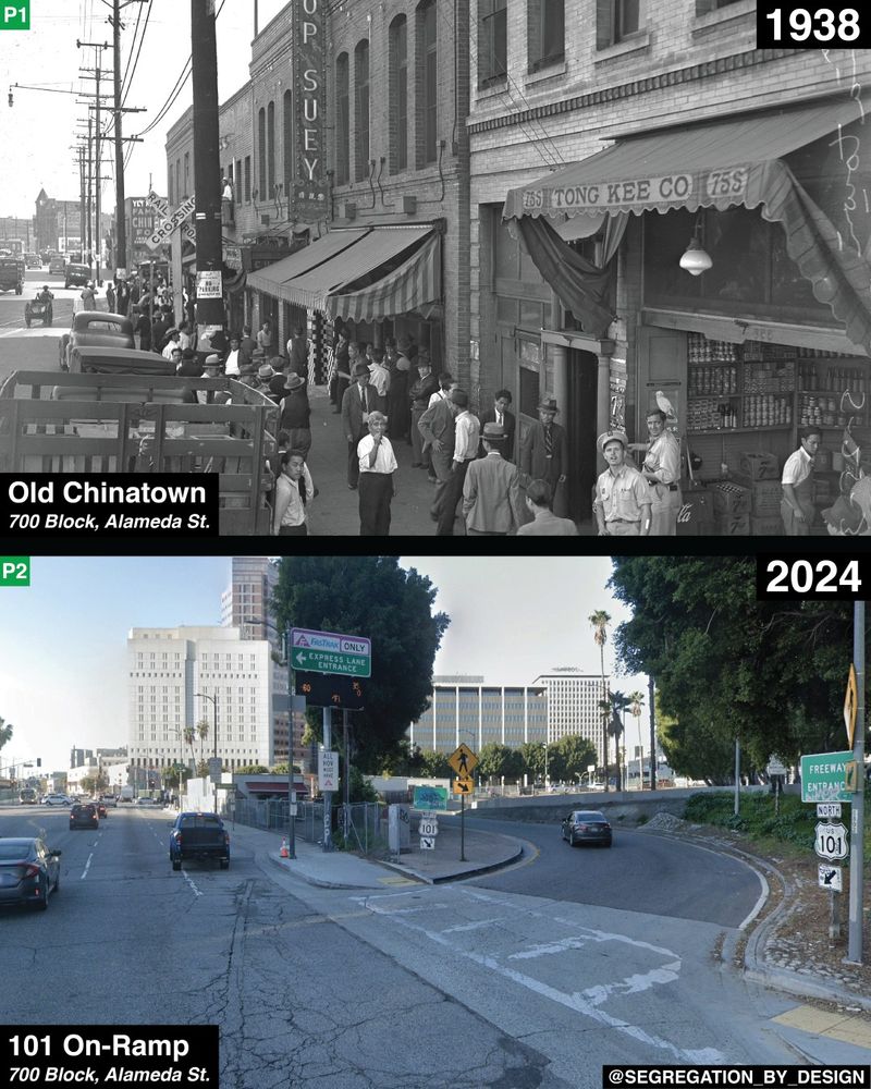
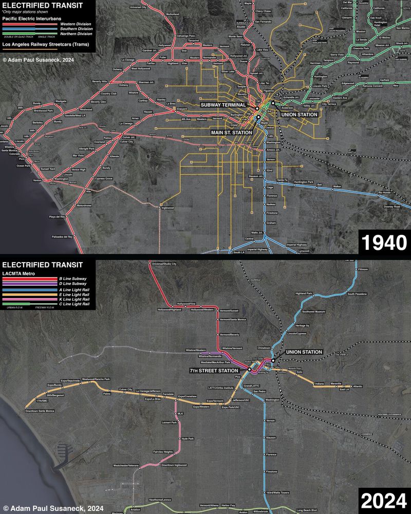
LA’s original Chinatown, before-and-after it was entirely demolished for the construction of Union Station, the Hollywood Freeway, and the creation of “Civic Center” between the 1930s-1950s. More info and images here: www.segregationbydesign.com/los-angeles/...
April 1, 2025 at 1:46 PM
LA’s original Chinatown, before-and-after it was entirely demolished for the construction of Union Station, the Hollywood Freeway, and the creation of “Civic Center” between the 1930s-1950s. More info and images here: www.segregationbydesign.com/los-angeles/...
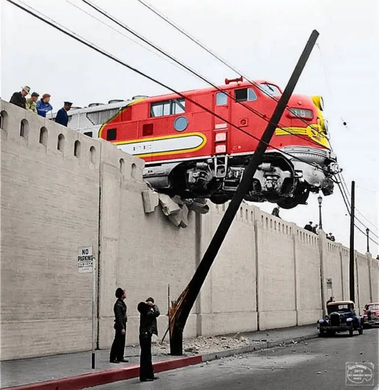
And more info specifically about this incident here: laist.com/news/found-i...
December 19, 2024 at 2:00 PM
And more info specifically about this incident here: laist.com/news/found-i...
Specifically, the Northern District was discontinued, shown in green on this map. More info about Aliso here: www.segregationbydesign.com/los-angeles/...
December 19, 2024 at 1:58 PM
Specifically, the Northern District was discontinued, shown in green on this map. More info about Aliso here: www.segregationbydesign.com/los-angeles/...
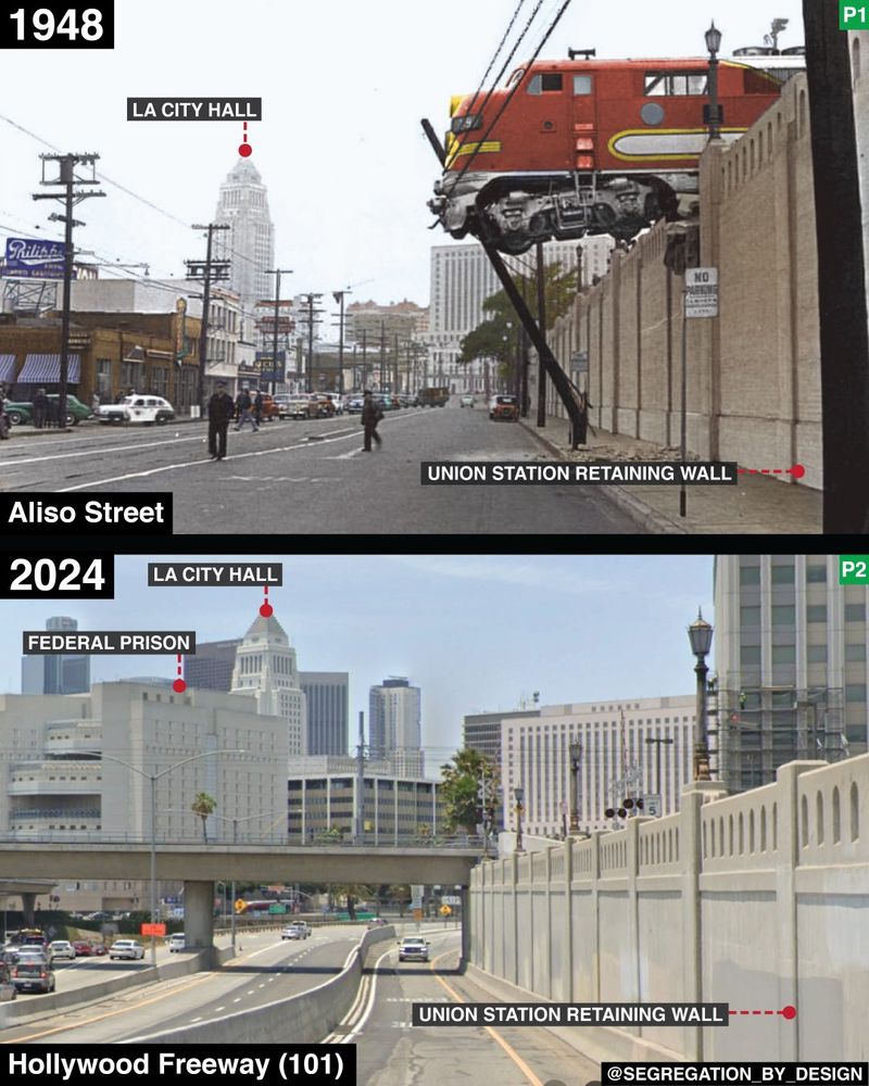
View of Aliso St. in Downtown LA, before-and-after it was transformed into a frontage road for the 101. Aliso was the Pacific Electric's only route across the LA River, and conversion of the street to a highway in 1951 resulted in the abandonment of all lines east of the river.
December 19, 2024 at 1:56 PM
View of Aliso St. in Downtown LA, before-and-after it was transformed into a frontage road for the 101. Aliso was the Pacific Electric's only route across the LA River, and conversion of the street to a highway in 1951 resulted in the abandonment of all lines east of the river.
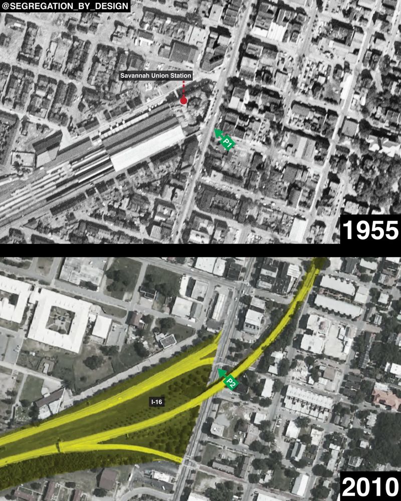
Before the station was replaced with a highway ramp, it was one of the primary commercial anchors and economic drivers of West Broad Street, historically the heart of Savannah’s Black and immigrant community.
December 18, 2024 at 5:15 PM
Before the station was replaced with a highway ramp, it was one of the primary commercial anchors and economic drivers of West Broad Street, historically the heart of Savannah’s Black and immigrant community.
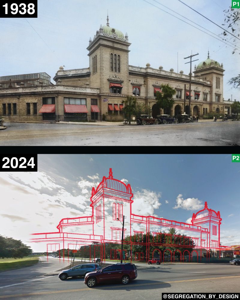
Savannah Union Station before-and-after it was demolished for construction of I-16 and “urban renewal” in the 1960s. More info: www.segregationbydesign.com/savannah/uni...
December 18, 2024 at 5:12 PM
Savannah Union Station before-and-after it was demolished for construction of I-16 and “urban renewal” in the 1960s. More info: www.segregationbydesign.com/savannah/uni...
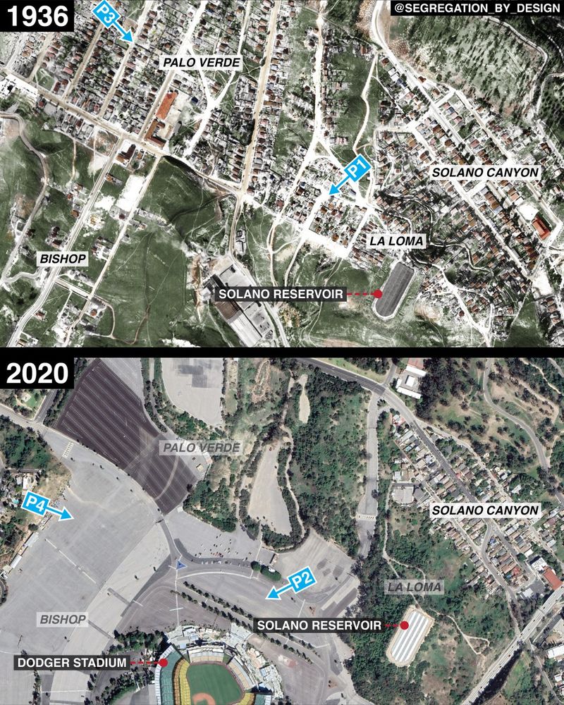
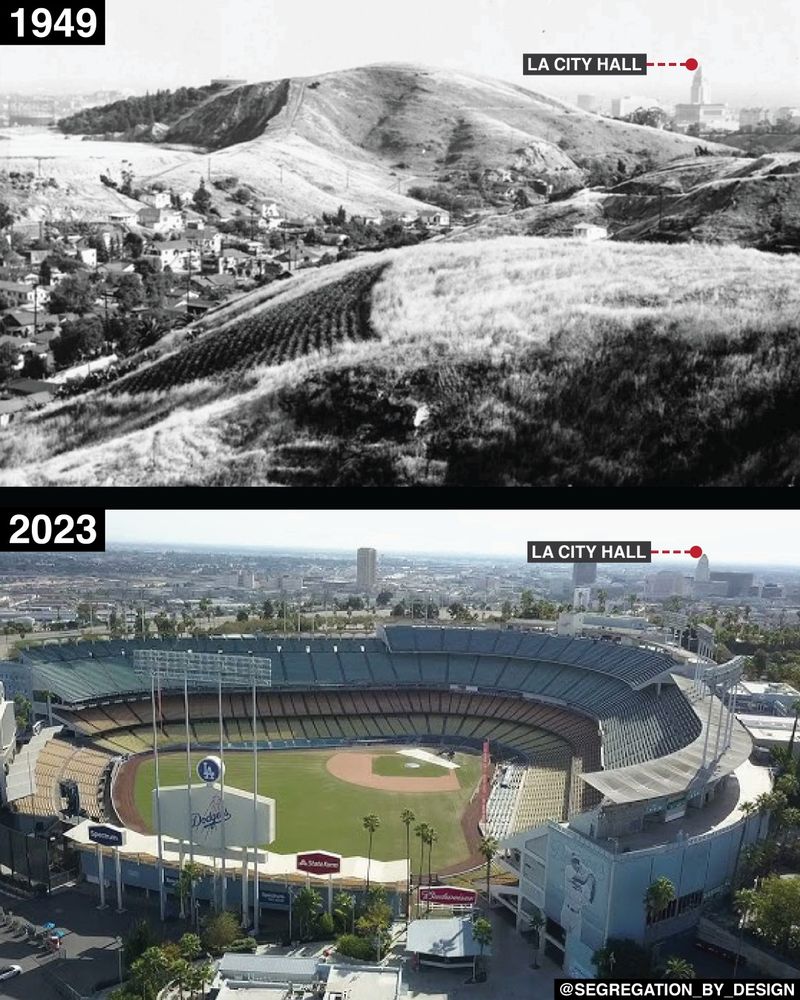
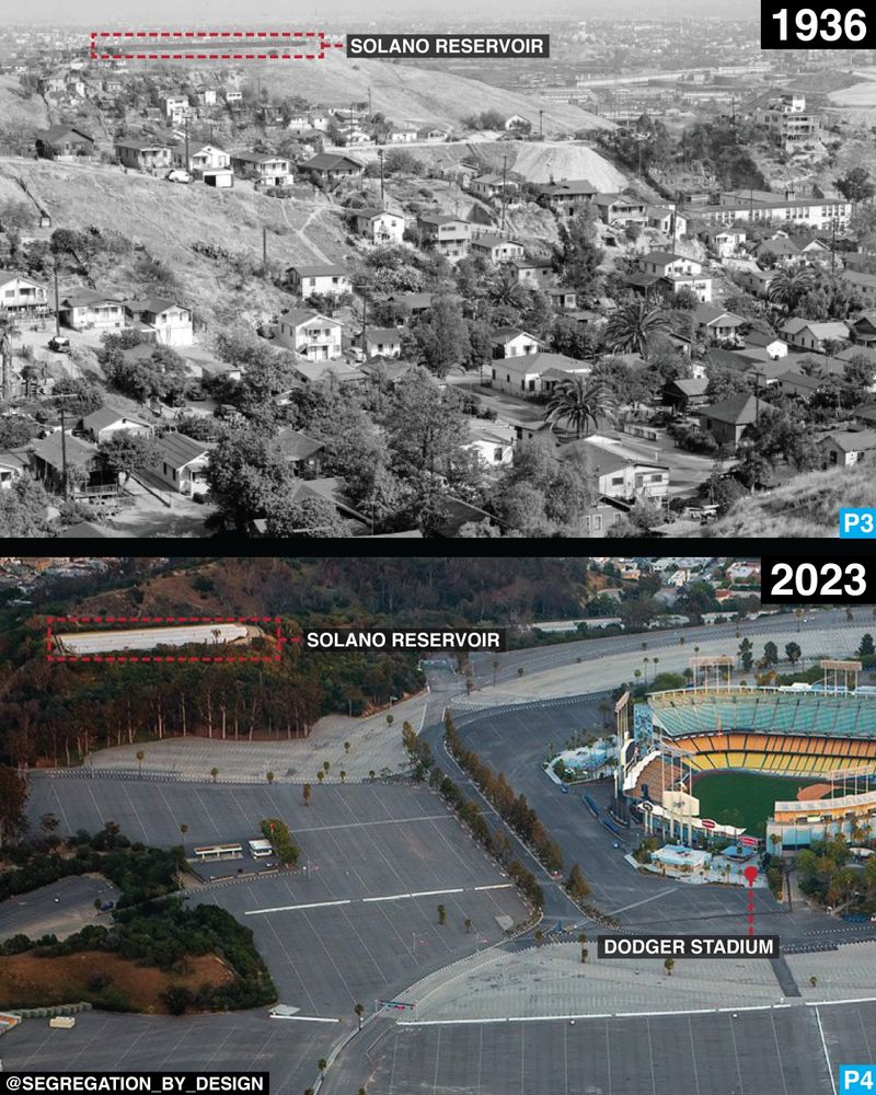
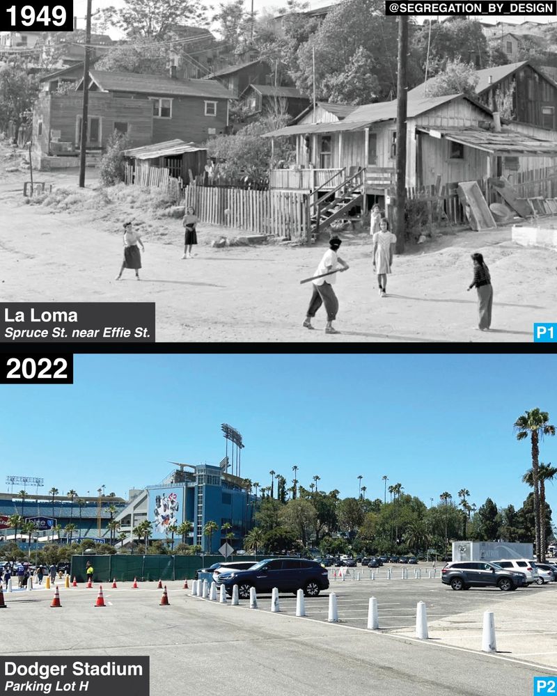
The Mexican-American community of La Loma, before-and-after the government forcibly evicted residents and demolished the neighborhood to make way for Dodger Stadium in 1959. More info: www.segregationbydesign.com/los-angeles/...
November 13, 2024 at 7:25 PM
The Mexican-American community of La Loma, before-and-after the government forcibly evicted residents and demolished the neighborhood to make way for Dodger Stadium in 1959. More info: www.segregationbydesign.com/los-angeles/...
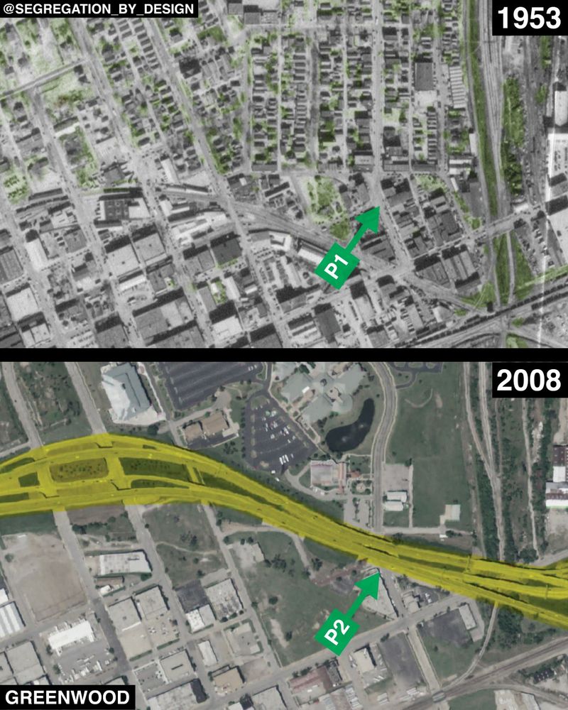
Ultimately, Greenwood—the famous "Black Wall Street"—was destroyed twice: once by a white supremacist mob in 1921, and again by highway construction and "urban renewal" in the 1960s. More from Smithsonian Mag: https://www.smithsonianmag.com/history/black-wall-streets-second-destruction-180977871/
August 10, 2023 at 7:36 AM
Ultimately, Greenwood—the famous "Black Wall Street"—was destroyed twice: once by a white supremacist mob in 1921, and again by highway construction and "urban renewal" in the 1960s. More from Smithsonian Mag: https://www.smithsonianmag.com/history/black-wall-streets-second-destruction-180977871/
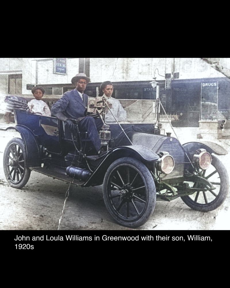
Like many other residents of Greenwood whose homes and businesses were burned, the Williams defied the hastily enacted policies which the city had passed to prevent the neighborhood’s reconstruction (rezoning much of it to industrial).
August 10, 2023 at 7:34 AM
Like many other residents of Greenwood whose homes and businesses were burned, the Williams defied the hastily enacted policies which the city had passed to prevent the neighborhood’s reconstruction (rezoning much of it to industrial).
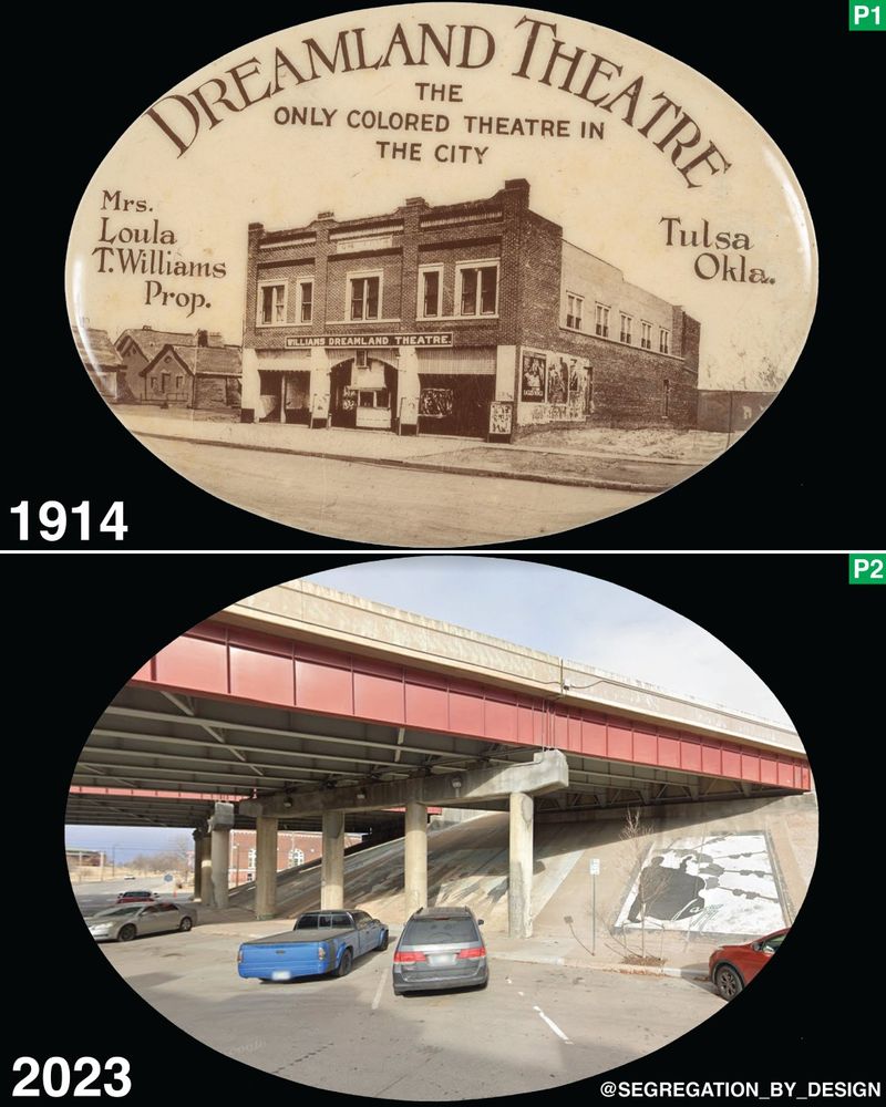
John & Loula Williams rebuilt the Williams Dreamland Theater after a white supremacist mob destroyed it and the rest of Greenwood in the 1921 massacre. The theater was a mainstay of the rebuilt neighborhood until Tulsa's Black Wall St. was destroyed again in the 1960s by construction of I-244.
August 10, 2023 at 7:33 AM
John & Loula Williams rebuilt the Williams Dreamland Theater after a white supremacist mob destroyed it and the rest of Greenwood in the 1921 massacre. The theater was a mainstay of the rebuilt neighborhood until Tulsa's Black Wall St. was destroyed again in the 1960s by construction of I-244.
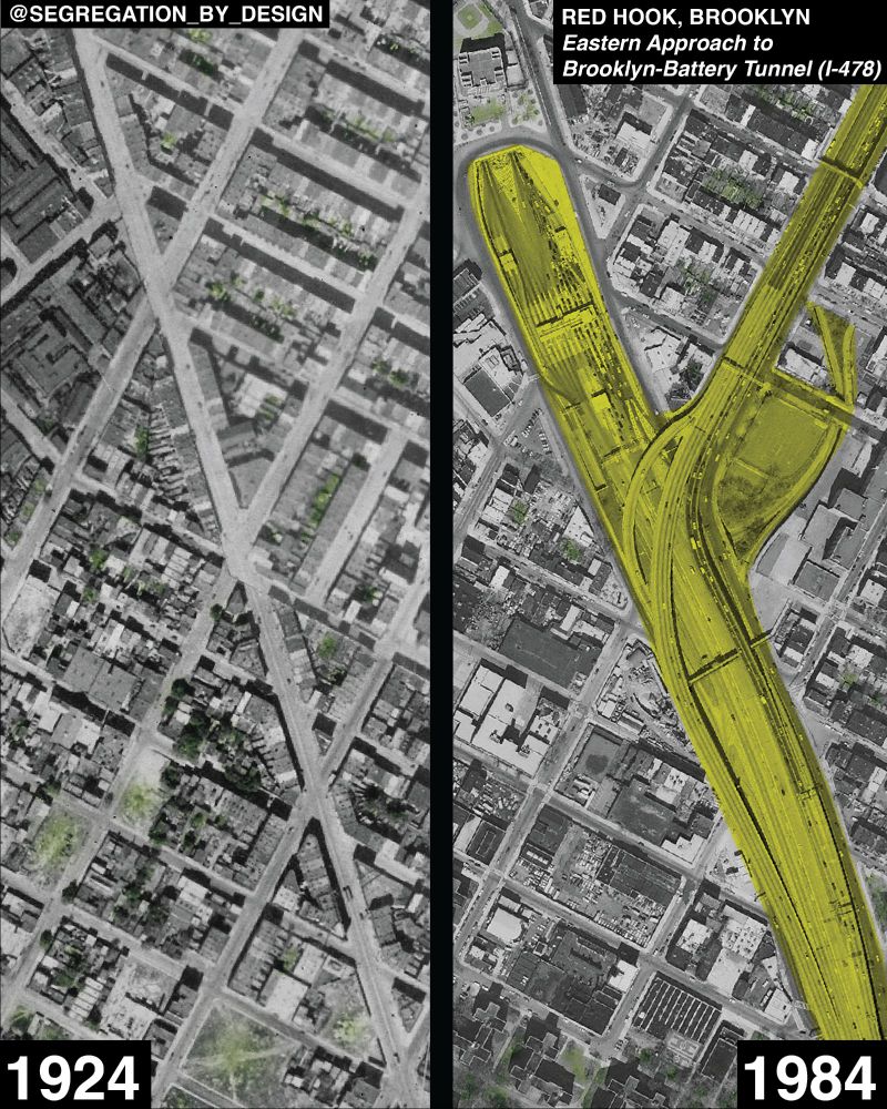
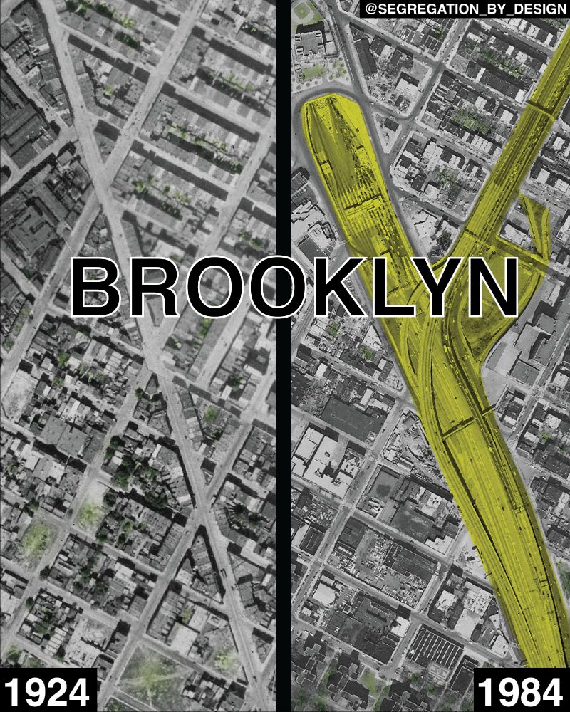
More on Red Hook here: https://www.segregationbydesign.com/brooklyn/red-hook
August 4, 2023 at 9:38 AM
More on Red Hook here: https://www.segregationbydesign.com/brooklyn/red-hook
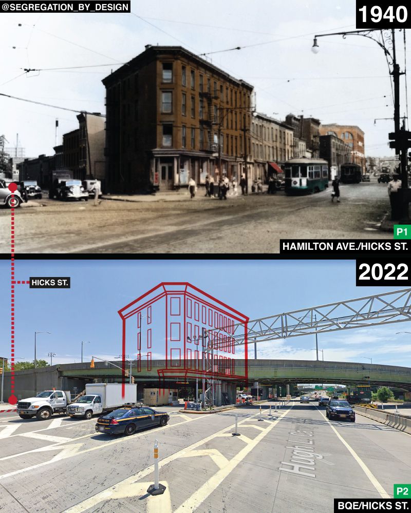
This image in particular is of Red Hook. The BQE cut through one of the neighborhood's main commercial corridors on Hamilton Ave and divided Red Hook from the rest of the borough.
August 4, 2023 at 9:37 AM
This image in particular is of Red Hook. The BQE cut through one of the neighborhood's main commercial corridors on Hamilton Ave and divided Red Hook from the rest of the borough.
Construction of the BQE required the displacement of tens of thousands of people. Designed by Robert Moses, the highway cut a 15-mile gash through some of the most densely populated neighborhoods on the planet. More info: https://www.segregationbydesign.com/brooklyn/brooklynqueens-expressway
August 4, 2023 at 9:34 AM
Construction of the BQE required the displacement of tens of thousands of people. Designed by Robert Moses, the highway cut a 15-mile gash through some of the most densely populated neighborhoods on the planet. More info: https://www.segregationbydesign.com/brooklyn/brooklynqueens-expressway
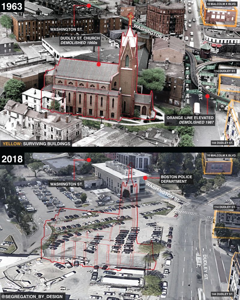
In Roxbury, officially known as the “heart of Black culture in Boston,” in the 1960s the government demolished the Dudley Street Church and replaced it with a police station. During this urban renewal project, the BRA displaced ~2,600 families (~8,600 people) in the Nubian Square area of Roxbury.
July 26, 2023 at 10:32 AM
In Roxbury, officially known as the “heart of Black culture in Boston,” in the 1960s the government demolished the Dudley Street Church and replaced it with a police station. During this urban renewal project, the BRA displaced ~2,600 families (~8,600 people) in the Nubian Square area of Roxbury.