


Robbi Bishop-Taylor 🛰️🌏
@satellitesci.bsky.social
Coastal Earth Observation Scientist from Canberra, Australia. Using satellite remote sensing 🛰️, open-source geospatial 🔓🗺️, Python + R 🧑💻 and dataviz 🎨 to map the earth through space + time... 🌏
Had a fantastic time presenting our new #eotides tide modelling Python package at #CoasttoCoast2025 - couldn't have asked for a more relevant coastal setting than the City of Gold Coast, still recovering from the impacts of #CycloneAlfred!
June 6, 2025 at 5:38 AM
Had a fantastic time presenting our new #eotides tide modelling Python package at #CoasttoCoast2025 - couldn't have asked for a more relevant coastal setting than the City of Gold Coast, still recovering from the impacts of #CycloneAlfred!
Excited to share a new paper in @joss-openjournals.bsky.social: "eo-tides: Tide modelling tools for large-scale satellite Earth observation analysis" 🌊🛰️
A new #opensource Python package designed to help combine satellite data with ocean tide modelling!
joss.theoj.org/papers/10.21...
A new #opensource Python package designed to help combine satellite data with ocean tide modelling!
joss.theoj.org/papers/10.21...
June 5, 2025 at 1:05 AM
Excited to share a new paper in @joss-openjournals.bsky.social: "eo-tides: Tide modelling tools for large-scale satellite Earth observation analysis" 🌊🛰️
A new #opensource Python package designed to help combine satellite data with ocean tide modelling!
joss.theoj.org/papers/10.21...
A new #opensource Python package designed to help combine satellite data with ocean tide modelling!
joss.theoj.org/papers/10.21...
New #DEACoastlines annual shoreline data for 2024 is now live! 🌊🛰️🎉
2024 was a relatively stable year for coastal change across Australia, with mostly moderate and balanced rates of growth and retreat across our coastline.
Interactive map: maps.dea.ga.gov.au/story/DEACoa...
2024 was a relatively stable year for coastal change across Australia, with mostly moderate and balanced rates of growth and retreat across our coastline.
Interactive map: maps.dea.ga.gov.au/story/DEACoa...
May 19, 2025 at 1:23 AM
New #DEACoastlines annual shoreline data for 2024 is now live! 🌊🛰️🎉
2024 was a relatively stable year for coastal change across Australia, with mostly moderate and balanced rates of growth and retreat across our coastline.
Interactive map: maps.dea.ga.gov.au/story/DEACoa...
2024 was a relatively stable year for coastal change across Australia, with mostly moderate and balanced rates of growth and retreat across our coastline.
Interactive map: maps.dea.ga.gov.au/story/DEACoa...
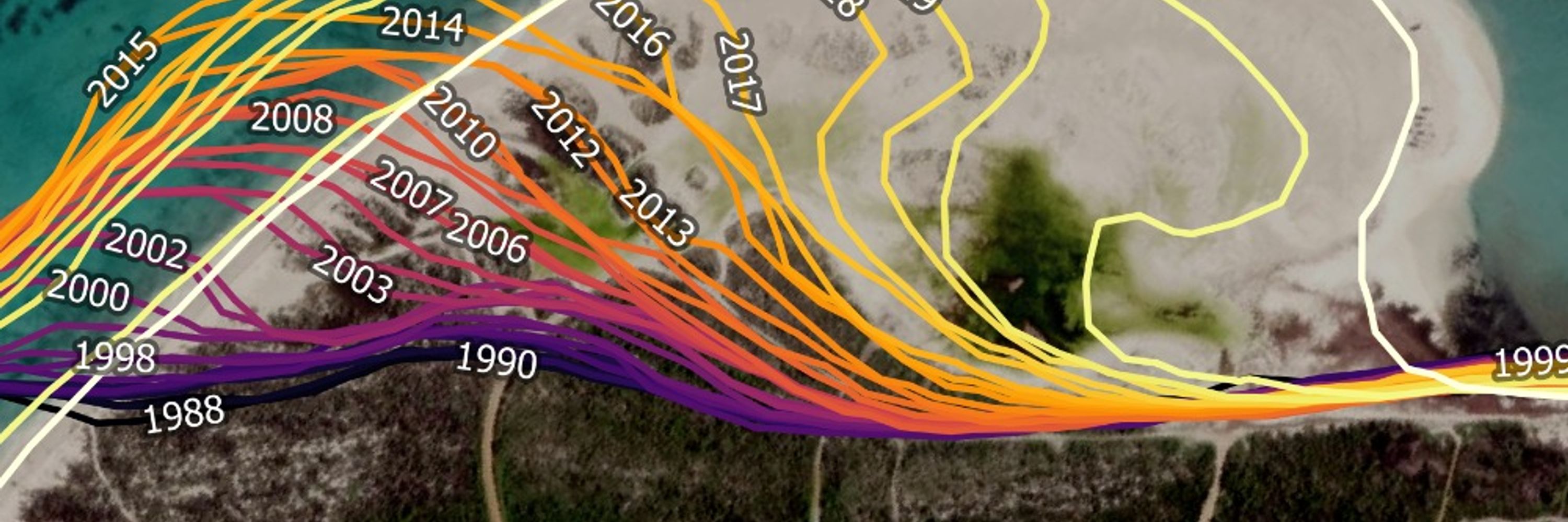
The slow growth of a large sand spit as it intrudes into Melbourne's Altona Beach, captured by #Sentinel2 🛰️
This spit has been moving towards Altona for about 25 years now, averaging 50 metres of growth per year since 2000. It's now over 1.3 km long with no sign of slowing down!
This spit has been moving towards Altona for about 25 years now, averaging 50 metres of growth per year since 2000. It's now over 1.3 km long with no sign of slowing down!
March 10, 2025 at 3:52 AM
The slow growth of a large sand spit as it intrudes into Melbourne's Altona Beach, captured by #Sentinel2 🛰️
This spit has been moving towards Altona for about 25 years now, averaging 50 metres of growth per year since 2000. It's now over 1.3 km long with no sign of slowing down!
This spit has been moving towards Altona for about 25 years now, averaging 50 metres of growth per year since 2000. It's now over 1.3 km long with no sign of slowing down!
^ This is for a site with a strong bias towards low tide imagery in Landsat and Sentinel-2 data. These biases vary greatly across the world's coastlines - a major challenge for coastal analyses that rely on #EarthObservation data!
e.g. a different site where overpass time is a bit less important:
e.g. a different site where overpass time is a bit less important:
February 6, 2025 at 6:18 AM
^ This is for a site with a strong bias towards low tide imagery in Landsat and Sentinel-2 data. These biases vary greatly across the world's coastlines - a major challenge for coastal analyses that rely on #EarthObservation data!
e.g. a different site where overpass time is a bit less important:
e.g. a different site where overpass time is a bit less important:
An unintentionally hilarious bouncing plot, simulating how overpass time affects how well a hypothetical #EO satellite like Landsat can monitor the tide cycle! 🏀🛰️🌊
Dots = what the satellite sees when it takes an image. Each frame is a different simulated overpass time - e.g. ~10-11 am for Landsat.
Dots = what the satellite sees when it takes an image. Each frame is a different simulated overpass time - e.g. ~10-11 am for Landsat.
February 6, 2025 at 6:15 AM
An unintentionally hilarious bouncing plot, simulating how overpass time affects how well a hypothetical #EO satellite like Landsat can monitor the tide cycle! 🏀🛰️🌊
Dots = what the satellite sees when it takes an image. Each frame is a different simulated overpass time - e.g. ~10-11 am for Landsat.
Dots = what the satellite sees when it takes an image. Each frame is a different simulated overpass time - e.g. ~10-11 am for Landsat.
A shifting tapestry of fire scars and vegetation regrowth etched across the landscape in remote north-eastern Western Australia.🔥🛰️
(Mapped with 30 years of #DigitalEarthAU Landsat imagery)
(Mapped with 30 years of #DigitalEarthAU Landsat imagery)
January 31, 2025 at 3:16 AM
A shifting tapestry of fire scars and vegetation regrowth etched across the landscape in remote north-eastern Western Australia.🔥🛰️
(Mapped with 30 years of #DigitalEarthAU Landsat imagery)
(Mapped with 30 years of #DigitalEarthAU Landsat imagery)
Lake Machattie! It's pretty spectacular - here's a few years of @esa.int Sentinel-2 imagery from floods in 2021-23:
#DigitalEarthAU
#DigitalEarthAU
January 24, 2025 at 11:14 PM
Lake Machattie! It's pretty spectacular - here's a few years of @esa.int Sentinel-2 imagery from floods in 2021-23:
#DigitalEarthAU
#DigitalEarthAU
It's alive! 😱 In all seriousness, that one is probably my favourite: Drosera binata from eastern Australia which has incredible tentacled leaves...
January 23, 2025 at 9:29 PM
It's alive! 😱 In all seriousness, that one is probably my favourite: Drosera binata from eastern Australia which has incredible tentacled leaves...