


Rob Van Kleeck
@robvk.bsky.social
Boston | Meteorologist | Air Quality Consultant | OU SOM '20 | Lyndon State '18 | Occasional DJ | Hudson Valley Native
34F at KMPO and the mid 50s next door in the Tri-State area, winter is coming!

November 10, 2025 at 5:22 PM
34F at KMPO and the mid 50s next door in the Tri-State area, winter is coming!
Can this happen in January?

October 8, 2025 at 6:07 PM
Can this happen in January?
Reposted by Rob Van Kleeck

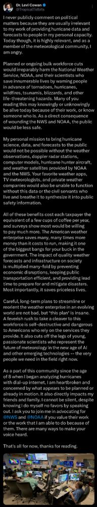
A statement I must make:
February 26, 2025 at 10:22 PM
A statement I must make:
Exciting prospects for a major east coast snowstorm next week on the overnight guidance. Good agreement between each ensemble suite - especially for a ~6 day leadtime - and these higher ceiling storms often materialize around then. But that doesn't guarantee anything, fingers crossed!

February 14, 2025 at 2:52 PM
Exciting prospects for a major east coast snowstorm next week on the overnight guidance. Good agreement between each ensemble suite - especially for a ~6 day leadtime - and these higher ceiling storms often materialize around then. But that doesn't guarantee anything, fingers crossed!
Reposted by Rob Van Kleeck

Lafayette, Louisiana got more snow today than many northern cities have seen *ALL SEASON*
It's been 3 years since Boston had a snowstorm this large
It's been 3 years since Boston had a snowstorm this large

January 21, 2025 at 11:10 PM
Lafayette, Louisiana got more snow today than many northern cities have seen *ALL SEASON*
It's been 3 years since Boston had a snowstorm this large
It's been 3 years since Boston had a snowstorm this large
Impressive concentric banding already underway in PA and MD

January 19, 2025 at 7:13 PM
Impressive concentric banding already underway in PA and MD
[1/2] The latest few cycles of the EPS have dramatically backed away from a cutoff southern stream in the Gulf of California next week at relatively short lead times (~130 hours). This is good news for wildfire relief efforts as it may reduce the severity of PGFs across the Transverse Ranges.

January 16, 2025 at 3:02 PM
[1/2] The latest few cycles of the EPS have dramatically backed away from a cutoff southern stream in the Gulf of California next week at relatively short lead times (~130 hours). This is good news for wildfire relief efforts as it may reduce the severity of PGFs across the Transverse Ranges.
Big increase in east coast snow prospects on this morning's GFS ensemble. Many members and large MSLP spread near the benchmark with explosive deepening. Remains to be seen if this is an outlier run cycle, but this signal under 140 hours is exciting.

January 6, 2025 at 4:55 PM
Big increase in east coast snow prospects on this morning's GFS ensemble. Many members and large MSLP spread near the benchmark with explosive deepening. Remains to be seen if this is an outlier run cycle, but this signal under 140 hours is exciting.
12z HREF members coming in more robust with morning snowfall as the shortwave moves through. Morning commute timing and brief but moderate snowfall makes for a potentially hazardous combo, especially given quick accum. on cold ground from the departing arctic air.

December 23, 2024 at 4:55 PM
12z HREF members coming in more robust with morning snowfall as the shortwave moves through. Morning commute timing and brief but moderate snowfall makes for a potentially hazardous combo, especially given quick accum. on cold ground from the departing arctic air.
Getting Chilly out there!

December 23, 2024 at 3:09 AM
Getting Chilly out there!
Some solid ocean-effect has prompted NWS Norton to increase snow totals to advisory levels for eastern Mass

December 20, 2024 at 3:40 PM
Some solid ocean-effect has prompted NWS Norton to increase snow totals to advisory levels for eastern Mass
Some proper arctic air on its way to the NE this weekend. The European suite is noticeably colder than the GFS suite however; deterministic ECMWF runs showing widespread -20C 850mb temps. GEFS keeps things more progressive. The downstream rapid-fire shortwaves contribute to these discrepancies.


December 16, 2024 at 4:36 PM
Some proper arctic air on its way to the NE this weekend. The European suite is noticeably colder than the GFS suite however; deterministic ECMWF runs showing widespread -20C 850mb temps. GEFS keeps things more progressive. The downstream rapid-fire shortwaves contribute to these discrepancies.