


Jim Steenburgh
@professorpowder.bsky.social
Professor of Atmospheric Sciences, University of Utah; Fulbright Scholar; Author, Secrets of the Greatest Snow on Earth (book) and Wasatch Weather Weenies (blog); Posts my own.
E.g.: The exposed GSL bed has grown in importance, but is not the only dust source. The Milford Flat fire scar was once a big producer. Below is a movie of a dust event in 2010 looking west over the Salt Lake Valley. Much of the pre-frontal dust was from that scar. It's not a big producer today.
May 13, 2025 at 2:46 PM
E.g.: The exposed GSL bed has grown in importance, but is not the only dust source. The Milford Flat fire scar was once a big producer. Below is a movie of a dust event in 2010 looking west over the Salt Lake Valley. Much of the pre-frontal dust was from that scar. It's not a big producer today.
Hot, dry, dusty south wind hellscape over the Salt Lake Valley this afternoon

May 13, 2025 at 12:03 AM
Hot, dry, dusty south wind hellscape over the Salt Lake Valley this afternoon
Snowfall at Salt Lake City International Airport so far this season (12.7") is the 3rd lowest on record through March 10th behind 2014/15 (9.6") and 1933/34 (12.3").
We will, however, add to these totals starting later this week.
We will, however, add to these totals starting later this week.

March 11, 2025 at 1:57 PM
Snowfall at Salt Lake City International Airport so far this season (12.7") is the 3rd lowest on record through March 10th behind 2014/15 (9.6") and 1933/34 (12.3").
We will, however, add to these totals starting later this week.
We will, however, add to these totals starting later this week.
Just released statement from the American Meteorological Society urging strong support of NOAA and federal science agencies for the continued success of the weather enterprise and American people.

March 3, 2025 at 5:19 PM
Just released statement from the American Meteorological Society urging strong support of NOAA and federal science agencies for the continued success of the weather enterprise and American people.

With 9.2" so far, this season has produced the 2nd lowest amount of snowfall on record through Feb 17 in the Salt Lake City area per records from the National Weather Service (Record 2014/15 6.8").

February 18, 2025 at 11:44 PM
With 9.2" so far, this season has produced the 2nd lowest amount of snowfall on record through Feb 17 in the Salt Lake City area per records from the National Weather Service (Record 2014/15 6.8").
Your National Weather Service providing critical 24/7 public safety information for Utah from urban to rural areas. How much does this cost? For the US, the NWS budget is about $1.3 billion per year, or about $4 per person.
They aren't on bluesky so reproducing their tweet below.
They aren't on bluesky so reproducing their tweet below.
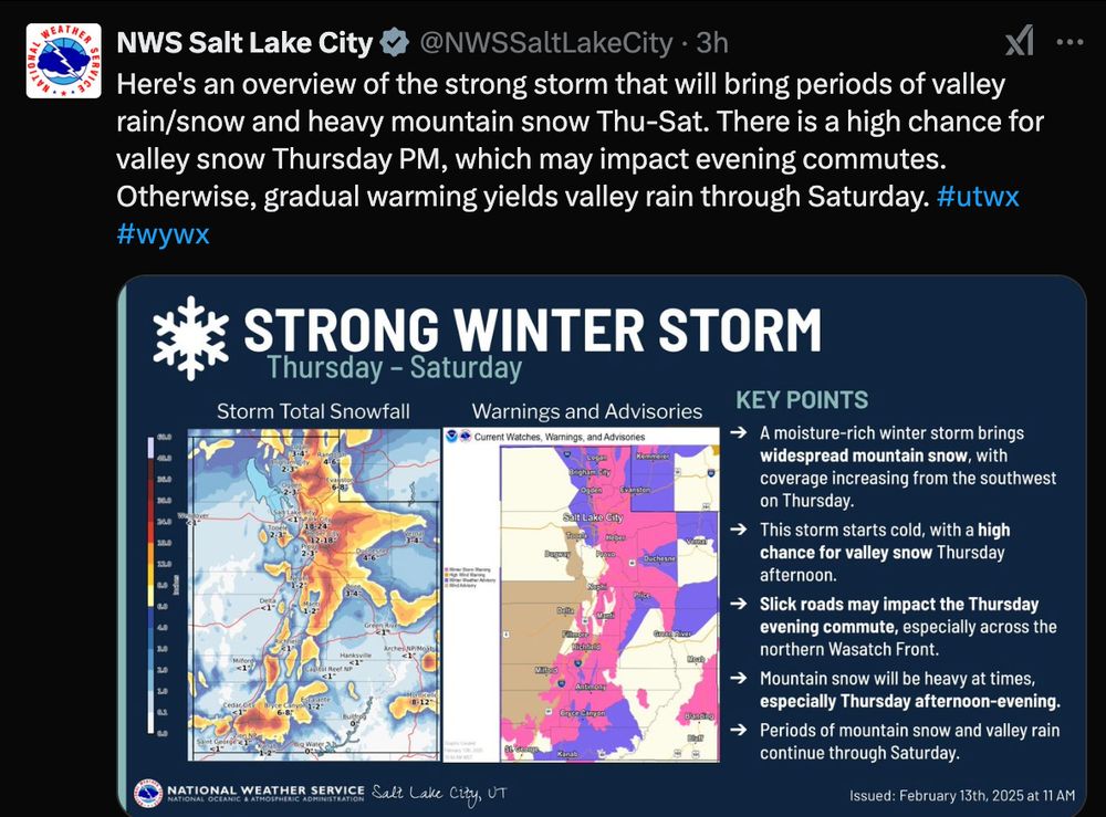
February 13, 2025 at 9:56 PM
Your National Weather Service providing critical 24/7 public safety information for Utah from urban to rural areas. How much does this cost? For the US, the NWS budget is about $1.3 billion per year, or about $4 per person.
They aren't on bluesky so reproducing their tweet below.
They aren't on bluesky so reproducing their tweet below.
Let's not forget, that the roots of this conspiracy go deep into the Hollywood Deep State. Woody Allen was the first to begin work on this, using the filming of his 1973 movie Sleeper as cover.

February 13, 2025 at 8:52 PM
Let's not forget, that the roots of this conspiracy go deep into the Hollywood Deep State. Woody Allen was the first to begin work on this, using the filming of his 1973 movie Sleeper as cover.
Red sky at morning, avalanche forecasters take warning

February 13, 2025 at 2:15 PM
Red sky at morning, avalanche forecasters take warning
You can't call it AI if it doesn't even know that you can't win the Super Bowl 16-16.

February 9, 2025 at 4:40 PM
You can't call it AI if it doesn't even know that you can't win the Super Bowl 16-16.
Big graupel and water totals at Alta today. Peak hourly water equivalent so far is 0.41"
The record at that site is 0.54" from 10-11 UTC 5 Jan 2008. Radar image below. Snowfall generated over the Alpine Ridge in a southwesterly atmospheric river just ahead of a cold front.
The record at that site is 0.54" from 10-11 UTC 5 Jan 2008. Radar image below. Snowfall generated over the Alpine Ridge in a southwesterly atmospheric river just ahead of a cold front.

February 7, 2025 at 8:54 PM
Big graupel and water totals at Alta today. Peak hourly water equivalent so far is 0.41"
The record at that site is 0.54" from 10-11 UTC 5 Jan 2008. Radar image below. Snowfall generated over the Alpine Ridge in a southwesterly atmospheric river just ahead of a cold front.
The record at that site is 0.54" from 10-11 UTC 5 Jan 2008. Radar image below. Snowfall generated over the Alpine Ridge in a southwesterly atmospheric river just ahead of a cold front.
My letter to Utah Senator John Curtis concerning reductions to NWS budget and staffing


February 7, 2025 at 12:46 AM
My letter to Utah Senator John Curtis concerning reductions to NWS budget and staffing
From the president of the American Meteorological Society (@ametsoc.org)

February 6, 2025 at 6:29 PM
From the president of the American Meteorological Society (@ametsoc.org)
The average temperature the past two days in Salt Lake City (62.5F) was a full 10F higher than anything previously observed on Feb 3-4.
In 1996, the average temperature on these dates was 9.8F.
In 1996, the average temperature on these dates was 9.8F.

February 5, 2025 at 2:34 PM
The average temperature the past two days in Salt Lake City (62.5F) was a full 10F higher than anything previously observed on Feb 3-4.
In 1996, the average temperature on these dates was 9.8F.
In 1996, the average temperature on these dates was 9.8F.
How insane was yesterdays min of 56 at the Salt Lake City airport? It's the highest min ever observed between 3 November and 17 March, tying 9 November 1927.
Nothing close to it has ever been observed in January or February. The prior record in those months was 51 (not shown)
Nothing close to it has ever been observed in January or February. The prior record in those months was 51 (not shown)

February 4, 2025 at 2:46 PM
How insane was yesterdays min of 56 at the Salt Lake City airport? It's the highest min ever observed between 3 November and 17 March, tying 9 November 1927.
Nothing close to it has ever been observed in January or February. The prior record in those months was 51 (not shown)
Nothing close to it has ever been observed in January or February. The prior record in those months was 51 (not shown)
February 2,2025. High at KSLC of 61, sky full of blowing dust, and the eye in Mordor painting the sky red to the west...

February 3, 2025 at 12:55 AM
February 2,2025. High at KSLC of 61, sky full of blowing dust, and the eye in Mordor painting the sky red to the west...
This isn't going to end well

January 31, 2025 at 11:21 PM
This isn't going to end well

Impressive snow totals along and near the Gulf Coast

January 22, 2025 at 3:10 PM
Impressive snow totals along and near the Gulf Coast
Pro Tip: With most ensemble members producing only ight amounts of snow @altaskiarea.bsky.social over the next 10 days, this would be a good time to book a flight to the Gulf Coast for freshies.

January 22, 2025 at 1:39 AM
Pro Tip: With most ensemble members producing only ight amounts of snow @altaskiarea.bsky.social over the next 10 days, this would be a good time to book a flight to the Gulf Coast for freshies.
Time series of the lowest temp at KSLC by water year (WY). The coldest cold surges ain't what they used to be. Last WY with < -10F was 95/96. Have not had sub zero since 2017. This AMs min 15F or so (waiting for final official report).

January 21, 2025 at 3:56 PM
Time series of the lowest temp at KSLC by water year (WY). The coldest cold surges ain't what they used to be. Last WY with < -10F was 95/96. Have not had sub zero since 2017. This AMs min 15F or so (waiting for final official report).
A remarkable winter dust event with emissions from the exposed lake bed of the GSL is ongoing right now in Salt Lake City. Images below show emissions from area east of Antelope Island and plume over Salt Lake Valley (both looking SWish. Link for sat image loop: col.st/SDWeo


January 20, 2025 at 5:44 PM
A remarkable winter dust event with emissions from the exposed lake bed of the GSL is ongoing right now in Salt Lake City. Images below show emissions from area east of Antelope Island and plume over Salt Lake Valley (both looking SWish. Link for sat image loop: col.st/SDWeo
Football as football should be

January 19, 2025 at 10:33 PM
Football as football should be
If you are attending, catch my talk today at #AMS2025 on extreme snowfall in Little Cottonwood Canyon, Utah. 1:30 PM in rm 203. I'll be coming in virtually.

January 15, 2025 at 7:09 PM
If you are attending, catch my talk today at #AMS2025 on extreme snowfall in Little Cottonwood Canyon, Utah. 1:30 PM in rm 203. I'll be coming in virtually.
From mesowest.utah.edu, peak gusts at stations in the LA/Oxnard fire weather zone with RH < 25% over the past 24 h.

January 8, 2025 at 7:55 PM
From mesowest.utah.edu, peak gusts at stations in the LA/Oxnard fire weather zone with RH < 25% over the past 24 h.