


James Pettus
@pettuswx.bsky.social
Just a weather nerd who makes weather graphics / SkyWarn certified / Aurora and Snow lover / Up and coming Storm Chaser / 6k+ on Twitter/X - jamespettus.co
Reposted by James Pettus

July 23, 2025 at 12:46 PM
A SIGNIFICANT QLCS/Derecho is LIKELY this evening into tonight. Significant wind gusts up to 100MPH are expected within the line along with damaging hail up to 5 INCHES with cells and clusters out ahead of the line. A few tornadoes (a few in which could be intense) can not be ruled out either.

June 8, 2025 at 3:39 PM
A SIGNIFICANT QLCS/Derecho is LIKELY this evening into tonight. Significant wind gusts up to 100MPH are expected within the line along with damaging hail up to 5 INCHES with cells and clusters out ahead of the line. A few tornadoes (a few in which could be intense) can not be ruled out either.
A new tornado watch has been issued.
Probs are 70/40 for the nerds.
Stay weather aware today.
Probs are 70/40 for the nerds.
Stay weather aware today.

June 5, 2025 at 6:18 PM
A new tornado watch has been issued.
Probs are 70/40 for the nerds.
Stay weather aware today.
Probs are 70/40 for the nerds.
Stay weather aware today.
A 10% hatched risk has been added in parts of western Texas and extreme eastern New Mexico for today. A few strong tornadoes are likely.

June 5, 2025 at 4:56 PM
A 10% hatched risk has been added in parts of western Texas and extreme eastern New Mexico for today. A few strong tornadoes are likely.
Best license plate in the state of Tennessee.

October 29, 2024 at 12:46 AM
Best license plate in the state of Tennessee.
Reposted by James Pettus

Harry Weinmans tornado/TDS frequency data shown at SLS also by proxy shows an issue my team is working to solve - the radar gaps in CONUS. Ours in the Tennessee Valley is currently somewhat covered by our X-band which has warned several tornadoes missed by NEXRAD… but more powerful systems needed


October 22, 2024 at 8:33 PM
Harry Weinmans tornado/TDS frequency data shown at SLS also by proxy shows an issue my team is working to solve - the radar gaps in CONUS. Ours in the Tennessee Valley is currently somewhat covered by our X-band which has warned several tornadoes missed by NEXRAD… but more powerful systems needed
I need some of this in my life rn

October 22, 2024 at 1:28 AM
I need some of this in my life rn
This is some incredible satellite imagery in the wpac from TD-22.

October 21, 2024 at 9:50 PM
This is some incredible satellite imagery in the wpac from TD-22.
Oscar is inching closer to landfall in Eastern Cuba.

October 20, 2024 at 9:25 PM
Oscar is inching closer to landfall in Eastern Cuba.
I’ve used this setup for about a year. Definitely gets the job done.

October 20, 2024 at 6:06 PM
I’ve used this setup for about a year. Definitely gets the job done.
Tropical Storm Oscar has formed in the Caribbean and boy does it look healthy. We went from a 60% invest to a pretty high end TS in *checks notes* 4 HOURS.

October 19, 2024 at 5:00 PM
Tropical Storm Oscar has formed in the Caribbean and boy does it look healthy. We went from a 60% invest to a pretty high end TS in *checks notes* 4 HOURS.
Per the NHC: Potential Tropical Cyclone Fifteen Expected to Bring Heavy Rainfall to Portions of Belize and Mexico.
Tropical Storm Nadine is likely in the coming hours.
Tropical Storm Nadine is likely in the coming hours.

October 18, 2024 at 8:41 PM
Per the NHC: Potential Tropical Cyclone Fifteen Expected to Bring Heavy Rainfall to Portions of Belize and Mexico.
Tropical Storm Nadine is likely in the coming hours.
Tropical Storm Nadine is likely in the coming hours.
Invest #95L has been organizing steadily today and the NHC has bumped development probabilities with this up to 70%. Nadine could be coming soon. Recon is scheduled to investigate tomorrow morning.

October 18, 2024 at 7:34 PM
Invest #95L has been organizing steadily today and the NHC has bumped development probabilities with this up to 70%. Nadine could be coming soon. Recon is scheduled to investigate tomorrow morning.
Reposted by James Pettus

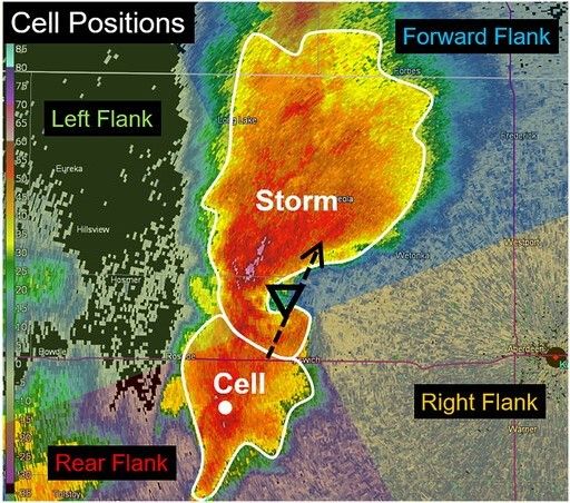
🎉PUBLISHED and open access: check out my latest paper on cell mergers and storm interactions here:
journals.ametsoc.org/view/journal...
Can the positions of nearby cells/mergers help us discriminate between tornadic, non-tornadic, and hail-producing supercells? We find evidence for "yes".
journals.ametsoc.org/view/journal...
Can the positions of nearby cells/mergers help us discriminate between tornadic, non-tornadic, and hail-producing supercells? We find evidence for "yes".
October 18, 2024 at 3:54 PM
🎉PUBLISHED and open access: check out my latest paper on cell mergers and storm interactions here:
journals.ametsoc.org/view/journal...
Can the positions of nearby cells/mergers help us discriminate between tornadic, non-tornadic, and hail-producing supercells? We find evidence for "yes".
journals.ametsoc.org/view/journal...
Can the positions of nearby cells/mergers help us discriminate between tornadic, non-tornadic, and hail-producing supercells? We find evidence for "yes".

If you see this, post weather.

October 18, 2024 at 3:04 PM
If you see this, post weather.
Reposted by James Pettus

Reposted by James Pettus

OK...I've created a starter pack for #WxSky (because that's what we're calling it) About 30 stormchasers, meteorologists, & photographers. If you'd like to be on or off the list let me know.
You can follow all these with one click or pick and choose.
go.bsky.app/BSfDE7c
You can follow all these with one click or pick and choose.
go.bsky.app/BSfDE7c
October 17, 2024 at 9:45 PM
OK...I've created a starter pack for #WxSky (because that's what we're calling it) About 30 stormchasers, meteorologists, & photographers. If you'd like to be on or off the list let me know.
You can follow all these with one click or pick and choose.
go.bsky.app/BSfDE7c
You can follow all these with one click or pick and choose.
go.bsky.app/BSfDE7c

October 17, 2024 at 9:43 PM
Reposted by James Pettus
The Radar dude has made it to Bluesky.
As a gift, I present to y'all the infamous May 3, 1999 scan that sampled winds over 300mph from DOW-3:
As a gift, I present to y'all the infamous May 3, 1999 scan that sampled winds over 300mph from DOW-3:


October 17, 2024 at 7:37 PM
The Radar dude has made it to Bluesky.
As a gift, I present to y'all the infamous May 3, 1999 scan that sampled winds over 300mph from DOW-3:
As a gift, I present to y'all the infamous May 3, 1999 scan that sampled winds over 300mph from DOW-3:
Check out thus Multi-Vortex tornado last week spawned by Hurricane Milton in Tequesta, FL as seen from a FL511 traffic camera.
October 17, 2024 at 9:32 PM
Check out thus Multi-Vortex tornado last week spawned by Hurricane Milton in Tequesta, FL as seen from a FL511 traffic camera.
NOAA has released there 2024-25 winter outlook. And no, we don’t know how much snow you are going to get.


October 17, 2024 at 5:53 PM
NOAA has released there 2024-25 winter outlook. And no, we don’t know how much snow you are going to get.
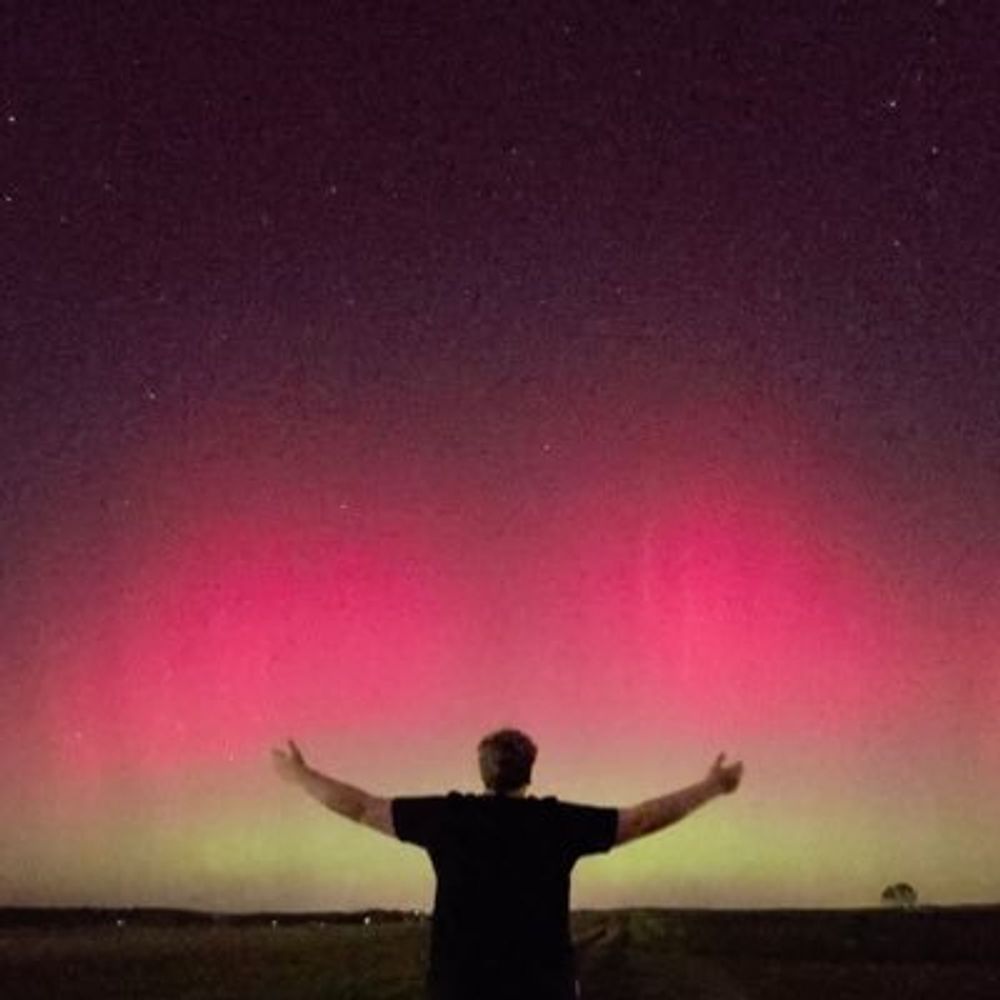
Aurora over Central Kentucky last Thursday.

October 17, 2024 at 3:23 PM
Aurora over Central Kentucky last Thursday.