


MissDelta Initiative
@missdeltaintiative.bsky.social
Mississippi River Delta Transition Initiative, funded by NAS Gulf Research Program
Advancing the best possible science to understand the future of the Birdsfoot Delta region. Committed to building a more diverse coastal workforce
missdelta.org
Advancing the best possible science to understand the future of the Birdsfoot Delta region. Committed to building a more diverse coastal workforce
missdelta.org
“My research highlights how advanced remote sensing techniques can reveal critical land deformation patterns in the Mississippi Delta and their links to vegetation dynamics under changing climatic scenarios," says Rahul.
#coastalscience #environmentalscience #mississippiriver #wetlands
#coastalscience #environmentalscience #mississippiriver #wetlands
October 17, 2025 at 3:49 AM
“My research highlights how advanced remote sensing techniques can reveal critical land deformation patterns in the Mississippi Delta and their links to vegetation dynamics under changing climatic scenarios," says Rahul.
#coastalscience #environmentalscience #mississippiriver #wetlands
#coastalscience #environmentalscience #mississippiriver #wetlands
Now Mariotti and other MissDelta modelers will use the same techniques to better understand the future of the Birdsfoot
October 7, 2025 at 9:40 PM
Now Mariotti and other MissDelta modelers will use the same techniques to better understand the future of the Birdsfoot
This research allows MissDelta to build a stronger understanding of river conditions during saltwater intrusion, including calibrating predictive numerical models, so we can help communities in the lower Mississippi River prepare for changing conditions and build a more sustainable future.
September 25, 2025 at 9:32 PM
This research allows MissDelta to build a stronger understanding of river conditions during saltwater intrusion, including calibrating predictive numerical models, so we can help communities in the lower Mississippi River prepare for changing conditions and build a more sustainable future.
If the wedge progresses upstream of water intakes in Plaquemines Parish, and even the Greater New Orleans area, it can impact drinking water supplies for all communities that rely on drinking water from the Mississippi River.
September 25, 2025 at 9:32 PM
If the wedge progresses upstream of water intakes in Plaquemines Parish, and even the Greater New Orleans area, it can impact drinking water supplies for all communities that rely on drinking water from the Mississippi River.
will likely require a decision by the US Army Corps of Engineers to initiate construction of the underwater sand sill at River Mile 63.
This will mark the extraordinary 4th consecutive year the sill will be required to stop continued upstream migration of the salt wedge.
This will mark the extraordinary 4th consecutive year the sill will be required to stop continued upstream migration of the salt wedge.
September 25, 2025 at 9:32 PM
will likely require a decision by the US Army Corps of Engineers to initiate construction of the underwater sand sill at River Mile 63.
This will mark the extraordinary 4th consecutive year the sill will be required to stop continued upstream migration of the salt wedge.
This will mark the extraordinary 4th consecutive year the sill will be required to stop continued upstream migration of the salt wedge.
These observations, along with projections of falling river discharge over the next month forecast by NOAA and linked to a prolonged drought in parts of the Mississippi River Basin,
September 25, 2025 at 9:32 PM
These observations, along with projections of falling river discharge over the next month forecast by NOAA and linked to a prolonged drought in parts of the Mississippi River Basin,
Researchers studied the temperature, salinity and sediment concentration of the water and the speed of the river and wedge current down the axis of the river below New Orleans. During this study the upstream toe (or tip) of the wedge was found to be around River Mile 33, below Port Sulphur.
September 25, 2025 at 9:32 PM
Researchers studied the temperature, salinity and sediment concentration of the water and the speed of the river and wedge current down the axis of the river below New Orleans. During this study the upstream toe (or tip) of the wedge was found to be around River Mile 33, below Port Sulphur.
Brannum says she hopes her research can help in coastal restoration. “I am most excited to use my research to guide vegetation plantings and restoration projects that leverage the benefits of vegetation to protect our coastlines.”
September 23, 2025 at 5:45 PM
Brannum says she hopes her research can help in coastal restoration. “I am most excited to use my research to guide vegetation plantings and restoration projects that leverage the benefits of vegetation to protect our coastlines.”
She uses an acoustic doppler current profiler to measure the speed of water flow in deeper parts of the channel.
Although the ADCP and dye measure different things, she says, they “do generally agree about the system having faster water speed through the channel compared to the platform.”
Although the ADCP and dye measure different things, she says, they “do generally agree about the system having faster water speed through the channel compared to the platform.”
September 23, 2025 at 5:45 PM
She uses an acoustic doppler current profiler to measure the speed of water flow in deeper parts of the channel.
Although the ADCP and dye measure different things, she says, they “do generally agree about the system having faster water speed through the channel compared to the platform.”
Although the ADCP and dye measure different things, she says, they “do generally agree about the system having faster water speed through the channel compared to the platform.”
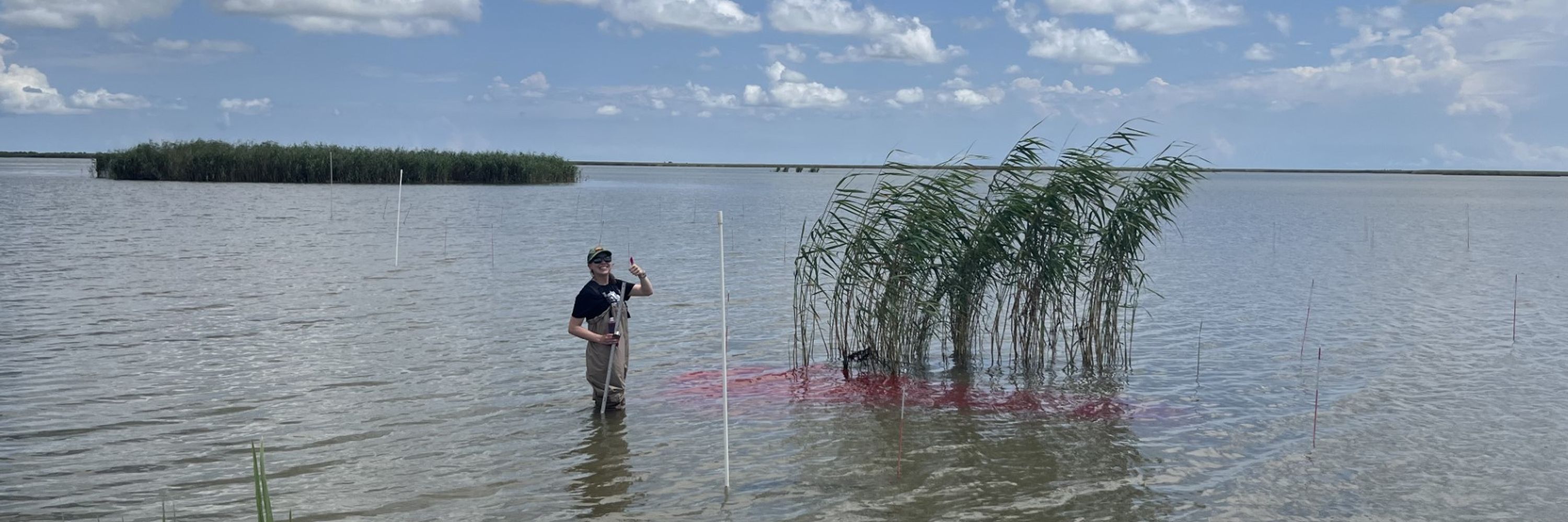
Brannum collects water samples to measure volume of sediment.
She tracks the flow of water on the marsh platform by putting dye in, then using drones to track the flow patterns.
She tracks the flow of water on the marsh platform by putting dye in, then using drones to track the flow patterns.
September 23, 2025 at 5:45 PM
Brannum collects water samples to measure volume of sediment.
She tracks the flow of water on the marsh platform by putting dye in, then using drones to track the flow patterns.
She tracks the flow of water on the marsh platform by putting dye in, then using drones to track the flow patterns.