

Mike F
@mikefeaver.bsky.social
Vancouver
Photos, maps, and occasionally opinions
Photos, maps, and occasionally opinions
Corner curb extensions are getting put in at a couple intersections on the west side of Broughton leading to the new elementary school
The crosswalk at Hastings still seems unnecessarily long - maybe to leave room for the planned bike path between Hastings and the seawall
The crosswalk at Hastings still seems unnecessarily long - maybe to leave room for the planned bike path between Hastings and the seawall


November 12, 2025 at 12:34 AM
Corner curb extensions are getting put in at a couple intersections on the west side of Broughton leading to the new elementary school
The crosswalk at Hastings still seems unnecessarily long - maybe to leave room for the planned bike path between Hastings and the seawall
The crosswalk at Hastings still seems unnecessarily long - maybe to leave room for the planned bike path between Hastings and the seawall
Looks like it's about to rain

November 10, 2025 at 12:34 AM
Looks like it's about to rain
The Hurley's on this map, so I guess (but it closes for the winter)
The BC government's road conditions site tells you to check local conditions on this site isurvivedthehurley.com?p=3723
The Oct 31 update:
The BC government's road conditions site tells you to check local conditions on this site isurvivedthehurley.com?p=3723
The Oct 31 update:

November 5, 2025 at 3:00 AM
The Hurley's on this map, so I guess (but it closes for the winter)
The BC government's road conditions site tells you to check local conditions on this site isurvivedthehurley.com?p=3723
The Oct 31 update:
The BC government's road conditions site tells you to check local conditions on this site isurvivedthehurley.com?p=3723
The Oct 31 update:
I'm not sure how the 1/4 block loading zone cul-de-sac is supposed to work


November 2, 2025 at 5:56 PM
I'm not sure how the 1/4 block loading zone cul-de-sac is supposed to work


Not really
But with a few refinements, it could be close to rail grade (except near the dam)
But with a few refinements, it could be close to rail grade (except near the dam)


October 18, 2025 at 4:40 AM
Not really
But with a few refinements, it could be close to rail grade (except near the dam)
But with a few refinements, it could be close to rail grade (except near the dam)
It's tough because you might have to choose between Hello Kitty and One Piece


October 16, 2025 at 4:05 AM
It's tough because you might have to choose between Hello Kitty and One Piece
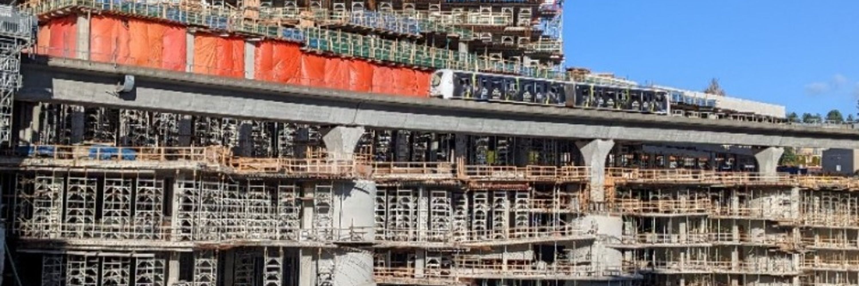
Balcony railings are starting

October 12, 2025 at 10:05 PM
Balcony railings are starting
On a sunny morning bike ride


October 2, 2025 at 2:57 AM
On a sunny morning bike ride
More trick than treat
Not a cheap vending machine
Not a cheap vending machine

October 1, 2025 at 10:30 AM
More trick than treat
Not a cheap vending machine
Not a cheap vending machine
On a rainy day bike ride


October 1, 2025 at 6:43 AM
On a rainy day bike ride
Would part of this have been another interurban or something more like the VV&E/Great Northern?

September 29, 2025 at 11:04 PM
Would part of this have been another interurban or something more like the VV&E/Great Northern?

Shin Yokohama Station from the train
Not exactly the TOD you might expect
Not exactly the TOD you might expect

September 22, 2025 at 12:52 AM
Shin Yokohama Station from the train
Not exactly the TOD you might expect
Not exactly the TOD you might expect
A view of the lower platform level
Platform 4 branches to Haneda and Kawasaki and trains go both directions
Platform 5 is south of platform 6
The other platforms are upstairs
Platform 4 branches to Haneda and Kawasaki and trains go both directions
Platform 5 is south of platform 6
The other platforms are upstairs


September 22, 2025 at 12:04 AM
A view of the lower platform level
Platform 4 branches to Haneda and Kawasaki and trains go both directions
Platform 5 is south of platform 6
The other platforms are upstairs
Platform 4 branches to Haneda and Kawasaki and trains go both directions
Platform 5 is south of platform 6
The other platforms are upstairs
September 21, 2025 at 11:42 PM
A view of the lower platform level
Platform 4 branches to Haneda and Kawasaki and trains go both directions
Platform 5 is south of platform 6
The other platforms are upstairs
Platform 4 branches to Haneda and Kawasaki and trains go both directions
Platform 5 is south of platform 6
The other platforms are upstairs
(The million daily riders and frequent grade crossings are typical features of private radial lines, though)
If you're in the station, they have a cool model of it in the concourse
If you're in the station, they have a cool model of it in the concourse

September 9, 2025 at 2:07 AM
(The million daily riders and frequent grade crossings are typical features of private radial lines, though)
If you're in the station, they have a cool model of it in the concourse
If you're in the station, they have a cool model of it in the concourse
This is this development, right?

August 31, 2025 at 7:57 PM
This is this development, right?
There's also a lake to swim in

August 24, 2025 at 7:47 PM
There's also a lake to swim in

The Capilano Timber Company's rail network was a lot more extensive than I had thought, extending to about as far north as Brunswick Mountain and on both sides of the river
That's half way to Squamish
Map from this 1988 master's thesis
open.library.ubc.ca/soa/cIRcle/c...
That's half way to Squamish
Map from this 1988 master's thesis
open.library.ubc.ca/soa/cIRcle/c...

August 23, 2025 at 11:24 PM
The Capilano Timber Company's rail network was a lot more extensive than I had thought, extending to about as far north as Brunswick Mountain and on both sides of the river
That's half way to Squamish
Map from this 1988 master's thesis
open.library.ubc.ca/soa/cIRcle/c...
That's half way to Squamish
Map from this 1988 master's thesis
open.library.ubc.ca/soa/cIRcle/c...
Here's the 2002 aerial from VanMap showing columns going up that don't leave any room at ground level for another set of tracks
The columns are closely spaced and right next to the SkyTrain guideway
The columns are closely spaced and right next to the SkyTrain guideway

August 23, 2025 at 6:08 PM
Here's the 2002 aerial from VanMap showing columns going up that don't leave any room at ground level for another set of tracks
The columns are closely spaced and right next to the SkyTrain guideway
The columns are closely spaced and right next to the SkyTrain guideway
A couple tracks went through Waterfront Centre as seen in this 1994 aerial from VanMap
There were more tracks under the new Burrard Viaduct in this 1986 photo before Waterfront Centre was built
There were more tracks under the new Burrard Viaduct in this 1986 photo before Waterfront Centre was built


August 23, 2025 at 5:15 PM
A couple tracks went through Waterfront Centre as seen in this 1994 aerial from VanMap
There were more tracks under the new Burrard Viaduct in this 1986 photo before Waterfront Centre was built
There were more tracks under the new Burrard Viaduct in this 1986 photo before Waterfront Centre was built
Here we are
Also Cordova and Burrard Viaduct construction from 1983
Also Cordova and Burrard Viaduct construction from 1983


August 23, 2025 at 4:57 PM
Here we are
Also Cordova and Burrard Viaduct construction from 1983
Also Cordova and Burrard Viaduct construction from 1983
This is silly (the highway, the portal, the airport and the associated height limit), but it shows what some people were thinking in 1969
It also shows the tracks adjacent to what is now Cordova and Granville Square
And then some other things from the archives
It also shows the tracks adjacent to what is now Cordova and Granville Square
And then some other things from the archives


August 23, 2025 at 4:10 PM
This is silly (the highway, the portal, the airport and the associated height limit), but it shows what some people were thinking in 1969
It also shows the tracks adjacent to what is now Cordova and Granville Square
And then some other things from the archives
It also shows the tracks adjacent to what is now Cordova and Granville Square
And then some other things from the archives