


Matthew Pfab 🇺🇦
@matthewpfabwx.bsky.social
Aspiring meteorologist, freelance with Live Storms Media, host of Western Washington Weather on YouTube, amateur landscape photographer. Posts about weather in the Pacific Northwest & around the US. #wawx
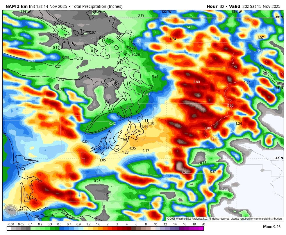
A heavy band of rain will stall out over the Puget Sound area today, with areas between Olympia and Everett likely picking up 0.75-1.25” of rain within the next 24 hours. Additionally, the Central Cascades will pick up 2-4” of rain with this, while the SW coast gets 1-2”. #wawx


November 14, 2025 at 3:25 PM
A heavy band of rain will stall out over the Puget Sound area today, with areas between Olympia and Everett likely picking up 0.75-1.25” of rain within the next 24 hours. Additionally, the Central Cascades will pick up 2-4” of rain with this, while the SW coast gets 1-2”. #wawx


20% off the Western Washington Weather Merch Store through November 16th!! Go check it out!! #wawx
westernwashingtonweather.myspreadshop.com
westernwashingtonweather.myspreadshop.com

November 11, 2025 at 8:15 PM
20% off the Western Washington Weather Merch Store through November 16th!! Go check it out!! #wawx
westernwashingtonweather.myspreadshop.com
westernwashingtonweather.myspreadshop.com


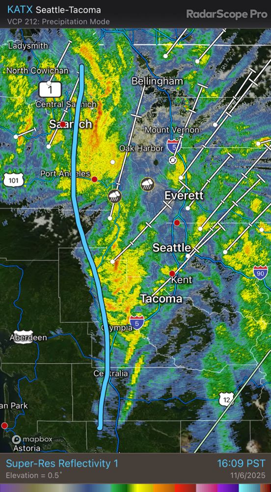
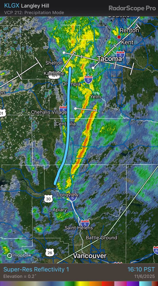
5:50 PM: Here comes round 2! Another strong band of rain, with gusty winds, rapidly deteriorating visibility, and briefly dangerous driving conditions, is ahead. This will impact areas from Seattle to Olympia and points eastward over the next hour! #wawx

November 7, 2025 at 1:54 AM
5:50 PM: Here comes round 2! Another strong band of rain, with gusty winds, rapidly deteriorating visibility, and briefly dangerous driving conditions, is ahead. This will impact areas from Seattle to Olympia and points eastward over the next hour! #wawx
Heads up, I-5 corridor! A strong cold frontal band is moving into the region within the next hour, bringing briefly very heavy rain, strong winds in excess of 40 mph, and low visibility/hazardous driving conditions. #wawx
November 7, 2025 at 12:17 AM
Heads up, I-5 corridor! A strong cold frontal band is moving into the region within the next hour, bringing briefly very heavy rain, strong winds in excess of 40 mph, and low visibility/hazardous driving conditions. #wawx
🌪️ Radar scan near Ilwaco, WA at the time a likely tornado/waterspout moved onshore off the Columbia River. That’s about as clear as it gets! Huge shoutout to @seattlewxguy.bsky.social, @markskaggs10.bsky.social, and @markstewarr.bsky.social for chasing and photographing this!! #wawx

November 6, 2025 at 1:22 AM
🌪️ Radar scan near Ilwaco, WA at the time a likely tornado/waterspout moved onshore off the Columbia River. That’s about as clear as it gets! Huge shoutout to @seattlewxguy.bsky.social, @markskaggs10.bsky.social, and @markstewarr.bsky.social for chasing and photographing this!! #wawx
The NWS SPC has increased the surface area of the PNW marginal risk, increasing it further north to include areas up to Olympia and westward to Hoquiam. Biggest threats are stong winds, ahil, and a VERY brief tornado. #wawx

November 5, 2025 at 8:09 PM
The NWS SPC has increased the surface area of the PNW marginal risk, increasing it further north to include areas up to Olympia and westward to Hoquiam. Biggest threats are stong winds, ahil, and a VERY brief tornado. #wawx
#CascadiaWinds gusting up to 40-50 mph in North Bend, 30-40 mph from Renton thru Maple Valley and toward Black Diamond, and 40-50 mph around Enumclaw (58 mph outside Enumclaw). Expect windy conditions through early tomorrow morning. #wawx

November 5, 2025 at 4:13 AM
#CascadiaWinds gusting up to 40-50 mph in North Bend, 30-40 mph from Renton thru Maple Valley and toward Black Diamond, and 40-50 mph around Enumclaw (58 mph outside Enumclaw). Expect windy conditions through early tomorrow morning. #wawx
Ahead of our next system, gusty #CascadiaWinds (gap winds) will reach 35-45 mph (potentially higher near North Bend & Enumclaw) from Tuesday evening to early Wednesday morning. Expect areas of power outages & tree damage. Stay tuned! #wawx


November 4, 2025 at 4:08 AM
Ahead of our next system, gusty #CascadiaWinds (gap winds) will reach 35-45 mph (potentially higher near North Bend & Enumclaw) from Tuesday evening to early Wednesday morning. Expect areas of power outages & tree damage. Stay tuned! #wawx


It’s that time again!! Snoqualmie Falls roaring Saturday evening following our #AtmosphericRiver! #wawx
November 2, 2025 at 12:44 AM
It’s that time again!! Snoqualmie Falls roaring Saturday evening following our #AtmosphericRiver! #wawx
Fast-developing low center moving in on the back end of our atmospheric river. Euro and NAM models showing windy conditions this morning-early afternoon, with gusts 45-50 mph for most areas (NAM is much stronger, Euro seems more reasonable). Be aware and stay tuned! #wawx


November 1, 2025 at 1:17 PM
Fast-developing low center moving in on the back end of our atmospheric river. Euro and NAM models showing windy conditions this morning-early afternoon, with gusts 45-50 mph for most areas (NAM is much stronger, Euro seems more reasonable). Be aware and stay tuned! #wawx
🌧️🎃👻 Happy Hallo-wet, #Seattle! Quite a soaker out there as our #AtmosphericRiver impacts the region! #wawx

November 1, 2025 at 12:29 AM
🌧️🎃👻 Happy Hallo-wet, #Seattle! Quite a soaker out there as our #AtmosphericRiver impacts the region! #wawx
Wind Advisory now in effect for the lowlands & coast from 9 AM to 5 PM on Saturday, for gusts up to 45 mph. (Note: Whatcom, San Juan, Island, and Jefferson Counties are under an older but still active alert). #wawx

October 31, 2025 at 10:56 PM
Wind Advisory now in effect for the lowlands & coast from 9 AM to 5 PM on Saturday, for gusts up to 45 mph. (Note: Whatcom, San Juan, Island, and Jefferson Counties are under an older but still active alert). #wawx
🎃👻☔️ RAINY HALLOWEEN AHEAD!!!
➡️ Rain begins midday Friday, continuing thru midday Saturday (7 PM simulated radar shown)
➡️ Moderate rain during prime trick-or-treating time (raincoat will be needed!)
➡️ Totals thru Sat. of 1-1.5", up to 2" coast/mtns
#wawx #Halloween
➡️ Rain begins midday Friday, continuing thru midday Saturday (7 PM simulated radar shown)
➡️ Moderate rain during prime trick-or-treating time (raincoat will be needed!)
➡️ Totals thru Sat. of 1-1.5", up to 2" coast/mtns
#wawx #Halloween


October 31, 2025 at 6:25 AM
🎃👻☔️ RAINY HALLOWEEN AHEAD!!!
➡️ Rain begins midday Friday, continuing thru midday Saturday (7 PM simulated radar shown)
➡️ Moderate rain during prime trick-or-treating time (raincoat will be needed!)
➡️ Totals thru Sat. of 1-1.5", up to 2" coast/mtns
#wawx #Halloween
➡️ Rain begins midday Friday, continuing thru midday Saturday (7 PM simulated radar shown)
➡️ Moderate rain during prime trick-or-treating time (raincoat will be needed!)
➡️ Totals thru Sat. of 1-1.5", up to 2" coast/mtns
#wawx #Halloween
In this morning's video, I talked about the Euro and NBM being quite different for Seattle's precip amounts w/the upcoming Halloween #AtmosphericRiver. Euro showed 0.8" vs NBM showing 1.5". Now, look at our comparison post-12Z Euro. Good agreement on 1-1.5"! #wawx

October 29, 2025 at 6:47 PM
In this morning's video, I talked about the Euro and NBM being quite different for Seattle's precip amounts w/the upcoming Halloween #AtmosphericRiver. Euro showed 0.8" vs NBM showing 1.5". Now, look at our comparison post-12Z Euro. Good agreement on 1-1.5"! #wawx
Pretty fun day at Cape Disappointment on Saturday with @seattlewxguy.bsky.social! Safe to say I’ve never been “disappointed” here! #wawx


October 29, 2025 at 2:14 PM
Pretty fun day at Cape Disappointment on Saturday with @seattlewxguy.bsky.social! Safe to say I’ve never been “disappointed” here! #wawx
Frontal system moving through Western Washington Tuesday evening through Wednesday morning, with some showers on Wednesday. Expect 0.3-0.8” of rain across the region with this system! #wawx
October 29, 2025 at 6:02 AM
Frontal system moving through Western Washington Tuesday evening through Wednesday morning, with some showers on Wednesday. Expect 0.3-0.8” of rain across the region with this system! #wawx
Snoqualmie Pass CLOSED eastbound as of 10 PM Sunday, as a strong Puget Sound Convergence Zone slams the I-90 corridor. Nothing impacts Snoqualmie Pass like these rapid-onset PSCZ bands. Stay safe! #wawx


October 27, 2025 at 5:13 AM
Snoqualmie Pass CLOSED eastbound as of 10 PM Sunday, as a strong Puget Sound Convergence Zone slams the I-90 corridor. Nothing impacts Snoqualmie Pass like these rapid-onset PSCZ bands. Stay safe! #wawx
Quite a storm across Western Washington! 273K customers out across the state, PSE has 144K out. 59% of Grays Harbor County has no power after winds over 70 mph. Thurston County and the foothills/eastside getting the brunt of it. Gonna be awhile for some of this to be fixed. #wawx


October 26, 2025 at 7:23 AM
Quite a storm across Western Washington! 273K customers out across the state, PSE has 144K out. 59% of Grays Harbor County has no power after winds over 70 mph. Thurston County and the foothills/eastside getting the brunt of it. Gonna be awhile for some of this to be fixed. #wawx
