


Andrew Cutts
@map-andrew.bsky.social
Geospatial freelancer http://www.acgeospatial.co.uk/ Earth Observation #eochat
Reposted by Andrew Cutts

7 days until liftoff! 🚀
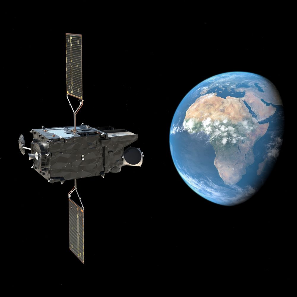
On 4 Nov 2025 at 18:03 local (French Guiana) / 21:03 UTC / 22:03 CET, Sentinel-1D launches aboard Ariane 6 — keeping Copernicus radar eyes on Earth, all weather, all the time. 🌍
#Sentinel1D #Copernicus #ESA #Ariane6 #EarthObservation
On 4 Nov 2025 at 18:03 local (French Guiana) / 21:03 UTC / 22:03 CET, Sentinel-1D launches aboard Ariane 6 — keeping Copernicus radar eyes on Earth, all weather, all the time. 🌍
#Sentinel1D #Copernicus #ESA #Ariane6 #EarthObservation
October 28, 2025 at 12:59 PM
7 days until liftoff! 🚀
On 4 Nov 2025 at 18:03 local (French Guiana) / 21:03 UTC / 22:03 CET, Sentinel-1D launches aboard Ariane 6 — keeping Copernicus radar eyes on Earth, all weather, all the time. 🌍
#Sentinel1D #Copernicus #ESA #Ariane6 #EarthObservation
On 4 Nov 2025 at 18:03 local (French Guiana) / 21:03 UTC / 22:03 CET, Sentinel-1D launches aboard Ariane 6 — keeping Copernicus radar eyes on Earth, all weather, all the time. 🌍
#Sentinel1D #Copernicus #ESA #Ariane6 #EarthObservation
Reposted by Andrew Cutts
I wrote a thing about how #geospatial and #fintech don't speak the same language
open.substack.com/pub/geospati...
open.substack.com/pub/geospati...

Why Fintech Still Doesn't Get Earth Observation ROI: The Cultural Chasm
Why Did I Write This
open.substack.com
October 7, 2025 at 12:16 AM
I wrote a thing about how #geospatial and #fintech don't speak the same language
open.substack.com/pub/geospati...
open.substack.com/pub/geospati...
New blog. In Praise of the Digital Earth Africa Sandbox. Its back! A very good place to learn to work with Earth observation data and Python.
www.acgeospatial.co.uk/in-praise-of...
#Earthobervation
#eochat
#opendatacube
www.acgeospatial.co.uk/in-praise-of...
#Earthobervation
#eochat
#opendatacube

September 11, 2025 at 8:55 AM
New blog. In Praise of the Digital Earth Africa Sandbox. Its back! A very good place to learn to work with Earth observation data and Python.
www.acgeospatial.co.uk/in-praise-of...
#Earthobervation
#eochat
#opendatacube
www.acgeospatial.co.uk/in-praise-of...
#Earthobervation
#eochat
#opendatacube
Reposted by Andrew Cutts

🚀 New Feature in Leafmap – Interactive Time-Series Visualization! 🌍🛰️
Leafmap now supports time sliders for visualizing large collections of remote sensing images.
Try it out
Web App: huggingface.co/spaces/giswq...
Notebook: leafmap.org/maplibre/tim...
#geospatial #leafmap #opensource #mapping
Leafmap now supports time sliders for visualizing large collections of remote sensing images.
Try it out
Web App: huggingface.co/spaces/giswq...
Notebook: leafmap.org/maplibre/tim...
#geospatial #leafmap #opensource #mapping
August 10, 2025 at 8:08 PM
🚀 New Feature in Leafmap – Interactive Time-Series Visualization! 🌍🛰️
Leafmap now supports time sliders for visualizing large collections of remote sensing images.
Try it out
Web App: huggingface.co/spaces/giswq...
Notebook: leafmap.org/maplibre/tim...
#geospatial #leafmap #opensource #mapping
Leafmap now supports time sliders for visualizing large collections of remote sensing images.
Try it out
Web App: huggingface.co/spaces/giswq...
Notebook: leafmap.org/maplibre/tim...
#geospatial #leafmap #opensource #mapping
Reposted by Andrew Cutts

🚨 Applications are now open!
We are excited to announce that the @geospatialwomen.bsky.social Mentorship Programme is now accepting applications for our 25/26 cohort, open until 7th September!
🔗 Interested? Apply here: lnkd.in/ek7veWdG
#gischat #remotesensing #geospatial #eo #gis #mentorship
We are excited to announce that the @geospatialwomen.bsky.social Mentorship Programme is now accepting applications for our 25/26 cohort, open until 7th September!
🔗 Interested? Apply here: lnkd.in/ek7veWdG
#gischat #remotesensing #geospatial #eo #gis #mentorship

August 11, 2025 at 3:16 PM
🚨 Applications are now open!
We are excited to announce that the @geospatialwomen.bsky.social Mentorship Programme is now accepting applications for our 25/26 cohort, open until 7th September!
🔗 Interested? Apply here: lnkd.in/ek7veWdG
#gischat #remotesensing #geospatial #eo #gis #mentorship
We are excited to announce that the @geospatialwomen.bsky.social Mentorship Programme is now accepting applications for our 25/26 cohort, open until 7th September!
🔗 Interested? Apply here: lnkd.in/ek7veWdG
#gischat #remotesensing #geospatial #eo #gis #mentorship
Reposted by Andrew Cutts

🟢 Worth a read if you are using the Copernicus Browser and custom scripts. „Sentinel Hub Custom Scripts migration from EO Browser to Copernicus Browser“ by Mohor Gartner
medium.com/@mohor.gartn...
medium.com/@mohor.gartn...
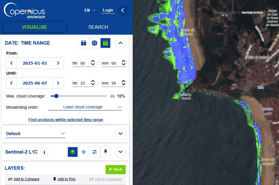
Sentinel Hub Custom Scripts migration from EO Browser to Copernicus Browser
Platform migration and update of my scripts.
medium.com
July 14, 2025 at 4:46 AM
🟢 Worth a read if you are using the Copernicus Browser and custom scripts. „Sentinel Hub Custom Scripts migration from EO Browser to Copernicus Browser“ by Mohor Gartner
medium.com/@mohor.gartn...
medium.com/@mohor.gartn...
Reposted by Andrew Cutts

Our latest deep-dive series is live now on the blog! 🗞️💡 Check out Chunks and Chunkability (parts one and two) now.
"It is a truth universally acknowledged in cloud native geospatial that data formats must be chunked."
Part One: element84.com/software-eng...
"It is a truth universally acknowledged in cloud native geospatial that data formats must be chunked."
Part One: element84.com/software-eng...
Chunks and Chunkability: Tyranny of the Chunk • Element 84
We discuss our attempt to understand chunks and chunking more deeply including where we are today and where we might go from here.
element84.com
July 10, 2025 at 9:32 PM
Our latest deep-dive series is live now on the blog! 🗞️💡 Check out Chunks and Chunkability (parts one and two) now.
"It is a truth universally acknowledged in cloud native geospatial that data formats must be chunked."
Part One: element84.com/software-eng...
"It is a truth universally acknowledged in cloud native geospatial that data formats must be chunked."
Part One: element84.com/software-eng...
Reposted by Andrew Cutts

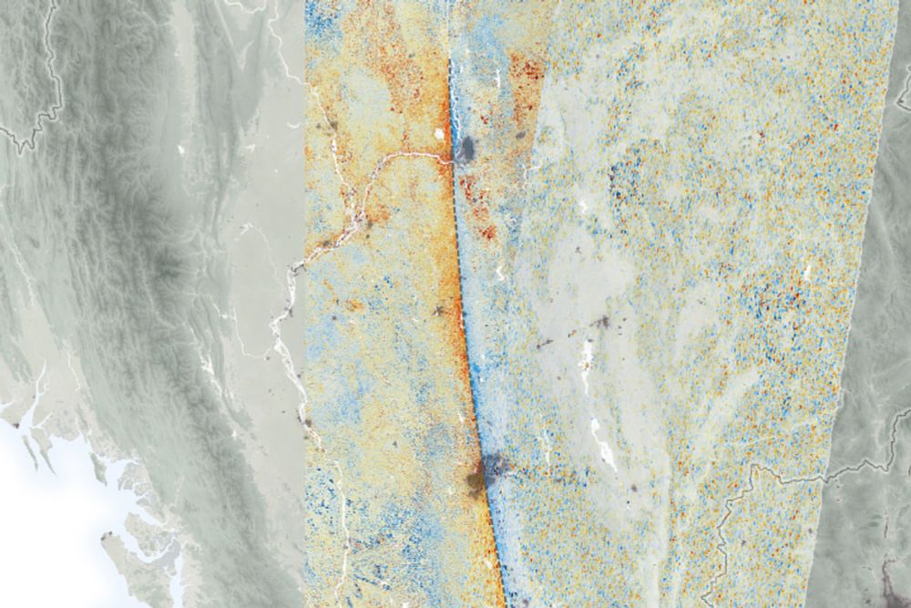
Two #Copernicus #Sentinel-2 images show the massive burn scar of ~100 km2 in northeast #Scotland caused by a fire between 28 June to 2 July. Uplands need better management, including rewilding & rewetting. #eochat @guyshrubsole.bsky.social @chrisgpackham.bsky.social @wildjustice.bsky.social
July 9, 2025 at 3:16 PM
Two #Copernicus #Sentinel-2 images show the massive burn scar of ~100 km2 in northeast #Scotland caused by a fire between 28 June to 2 July. Uplands need better management, including rewilding & rewetting. #eochat @guyshrubsole.bsky.social @chrisgpackham.bsky.social @wildjustice.bsky.social
New blog. Now I have a robust way of loading my Garmin tracks and activities into #PostGIS - I connect kepler.gl to it to visualise the data in a Jupyter Lab widget. This is a simple guide.
www.acgeospatial.co.uk/kepler-gl-in...
www.acgeospatial.co.uk/kepler-gl-in...
July 1, 2025 at 8:01 AM
New blog. Now I have a robust way of loading my Garmin tracks and activities into #PostGIS - I connect kepler.gl to it to visualise the data in a Jupyter Lab widget. This is a simple guide.
www.acgeospatial.co.uk/kepler-gl-in...
www.acgeospatial.co.uk/kepler-gl-in...
Reposted by Andrew Cutts
The fantastic first image released by @esa.int Biomass satellite.
In glorious false colour to represent its P-band radar imaging, capable of penetrating even the highest biomass forests in the Amazon and Congo.
In glorious false colour to represent its P-band radar imaging, capable of penetrating even the highest biomass forests in the Amazon and Congo.
June 23, 2025 at 11:37 AM
The fantastic first image released by @esa.int Biomass satellite.
In glorious false colour to represent its P-band radar imaging, capable of penetrating even the highest biomass forests in the Amazon and Congo.
In glorious false colour to represent its P-band radar imaging, capable of penetrating even the highest biomass forests in the Amazon and Congo.
New blog in my Garmin tracks series. This time 'Load activities from Garmin Connect and join to tracks in PostGIS' www.acgeospatial.co.uk/garmin-conne...
#garmin
#PostGIS
code:
github.com/acgeospatial...
#garmin
#PostGIS
code:
github.com/acgeospatial...

June 23, 2025 at 7:16 AM
New blog in my Garmin tracks series. This time 'Load activities from Garmin Connect and join to tracks in PostGIS' www.acgeospatial.co.uk/garmin-conne...
#garmin
#PostGIS
code:
github.com/acgeospatial...
#garmin
#PostGIS
code:
github.com/acgeospatial...
Reposted by Andrew Cutts

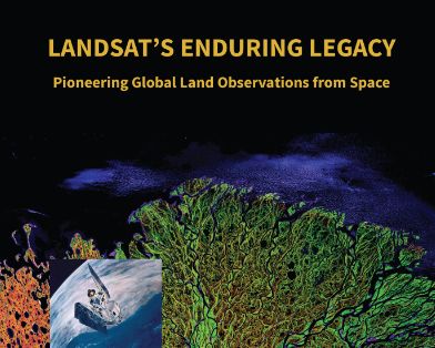
Great idea! While not a paper, a terrific resource is the book Landsat's Enduring Legacy: Pioneering Global Land Observations from Space.
Bit of everything. History of remote sensing. System design. Orbits. Applications. Has it all, AND is #openaccess!
Get a free copy: my.asprs.org/common/Uploa...
Bit of everything. History of remote sensing. System design. Orbits. Applications. Has it all, AND is #openaccess!
Get a free copy: my.asprs.org/common/Uploa...
June 17, 2025 at 10:12 PM
Great idea! While not a paper, a terrific resource is the book Landsat's Enduring Legacy: Pioneering Global Land Observations from Space.
Bit of everything. History of remote sensing. System design. Orbits. Applications. Has it all, AND is #openaccess!
Get a free copy: my.asprs.org/common/Uploa...
Bit of everything. History of remote sensing. System design. Orbits. Applications. Has it all, AND is #openaccess!
Get a free copy: my.asprs.org/common/Uploa...
New blog. This time handling updates from Garmin Connect to #PostGIS.
www.acgeospatial.co.uk/update-postg...
All the code is on GitHub - github.com/acgeospatial...
#python
#datamanagement
www.acgeospatial.co.uk/update-postg...
All the code is on GitHub - github.com/acgeospatial...
#python
#datamanagement

June 16, 2025 at 10:23 AM
New blog. This time handling updates from Garmin Connect to #PostGIS.
www.acgeospatial.co.uk/update-postg...
All the code is on GitHub - github.com/acgeospatial...
#python
#datamanagement
www.acgeospatial.co.uk/update-postg...
All the code is on GitHub - github.com/acgeospatial...
#python
#datamanagement
Reposted by Andrew Cutts

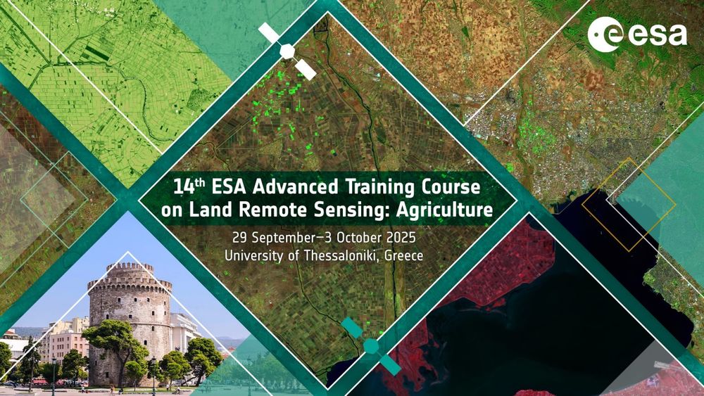
📢 Last 3 days to apply for #ESA 14th Advanced #Training Course on Land #RemoteSensing with a focus on #Agriculture!
📅 When: 29 September - 3 October 2025
📍 Where: Thessaloniki, Greece
👉 Deadline: 12 June 2025
🔗 More info and registration: landtraining2025.esa.int
#GISchat #EOchat #geosky #eo
📅 When: 29 September - 3 October 2025
📍 Where: Thessaloniki, Greece
👉 Deadline: 12 June 2025
🔗 More info and registration: landtraining2025.esa.int
#GISchat #EOchat #geosky #eo
June 9, 2025 at 6:53 AM
📢 Last 3 days to apply for #ESA 14th Advanced #Training Course on Land #RemoteSensing with a focus on #Agriculture!
📅 When: 29 September - 3 October 2025
📍 Where: Thessaloniki, Greece
👉 Deadline: 12 June 2025
🔗 More info and registration: landtraining2025.esa.int
#GISchat #EOchat #geosky #eo
📅 When: 29 September - 3 October 2025
📍 Where: Thessaloniki, Greece
👉 Deadline: 12 June 2025
🔗 More info and registration: landtraining2025.esa.int
#GISchat #EOchat #geosky #eo
New blog. This time Getting tracks from #Garmin connect to #PostGIS. I present two options with code. www.acgeospatial.co.uk/getting-trac...
Using #geopandas, #sqlalchemy
Using #geopandas, #sqlalchemy
Getting tracks from Garmin Connect to PostGIS – acgeospatial
www.acgeospatial.co.uk
June 8, 2025 at 2:44 PM
New blog. This time Getting tracks from #Garmin connect to #PostGIS. I present two options with code. www.acgeospatial.co.uk/getting-trac...
Using #geopandas, #sqlalchemy
Using #geopandas, #sqlalchemy
Reposted by Andrew Cutts

✨High above Earth, Copernicus Sentinel-4 will watch Europe’s air pollution *hourly*! 🤯 Unprecedented detail for forecasting & a clearer view of our atmosphere. 🌍 #EarthObservation
Source: https://phys.org/news/2025-06-fresh-sentinel-air.html
Source: https://phys.org/news/2025-06-fresh-sentinel-air.html
A breath of fresh data: Sentinel-4 innovates for clean air
From its vantage point outside Earth's atmosphere, more than 36,000 km above Earth's surface, the Copernicus Sentinel-4 mission will detect major air pollutants over Europe in unprecedented detail. It will observe how they vary on an hourly basis—a real breakthrough for air quality forecasting.
phys.org
June 7, 2025 at 3:35 PM
✨High above Earth, Copernicus Sentinel-4 will watch Europe’s air pollution *hourly*! 🤯 Unprecedented detail for forecasting & a clearer view of our atmosphere. 🌍 #EarthObservation
Source: https://phys.org/news/2025-06-fresh-sentinel-air.html
Source: https://phys.org/news/2025-06-fresh-sentinel-air.html
Reposted by Andrew Cutts

After 25 years of watching Earth's changes, Landsat 7 has been decommissioned. It helped monitor forests, glaciers, disasters, and coastlines, providing decades of open science data. Its archive will continue to support research and environmental management
🧪⚒️🌊🌋❄️
#Landsat
#RemoteSensing
#GIS
🧪⚒️🌊🌋❄️
#Landsat
#RemoteSensing
#GIS
End of an Era: Landsat 7 Decommissioned After 25 Years of Earth Observation
After 25 years of capturing Earth's changing landscape, the Landsat 7 satellite received its final transmission from the U.S. Geological Survey and was officially decommissioned June 4, closing a rema...
www.usgs.gov
June 6, 2025 at 12:08 AM
After 25 years of watching Earth's changes, Landsat 7 has been decommissioned. It helped monitor forests, glaciers, disasters, and coastlines, providing decades of open science data. Its archive will continue to support research and environmental management
🧪⚒️🌊🌋❄️
#Landsat
#RemoteSensing
#GIS
🧪⚒️🌊🌋❄️
#Landsat
#RemoteSensing
#GIS
A short blog on getting your tracks / routes from #Garmin Connect into #QGIS. www.acgeospatial.co.uk/getting-rout...
Getting routes from Garmin Connect to QGIS – acgeospatial
www.acgeospatial.co.uk
June 2, 2025 at 2:26 PM
A short blog on getting your tracks / routes from #Garmin Connect into #QGIS. www.acgeospatial.co.uk/getting-rout...
Reposted by Andrew Cutts
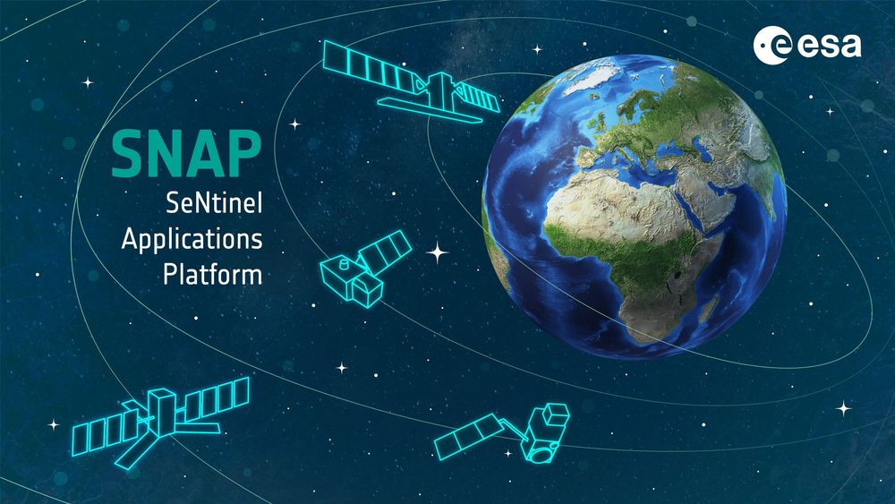
🚀SNAP 12 is here! 🌍
Marking 10 years of ESA's Sentinel App Platform with powerful new features:
🛰️Sentinel-1C support
⚙️JDK 21
🌐ETAD: smarter SLCs, interferograms & auto-download
🌍REACTIV, InSAR, OLCI/SLSTR
📦New vector tools
👉 step.esa.int/main/snap-12...
#EO #RemoteSensing #SentinelData #ESA #SNAP
Marking 10 years of ESA's Sentinel App Platform with powerful new features:
🛰️Sentinel-1C support
⚙️JDK 21
🌐ETAD: smarter SLCs, interferograms & auto-download
🌍REACTIV, InSAR, OLCI/SLSTR
📦New vector tools
👉 step.esa.int/main/snap-12...
#EO #RemoteSensing #SentinelData #ESA #SNAP
May 8, 2025 at 12:14 PM
🚀SNAP 12 is here! 🌍
Marking 10 years of ESA's Sentinel App Platform with powerful new features:
🛰️Sentinel-1C support
⚙️JDK 21
🌐ETAD: smarter SLCs, interferograms & auto-download
🌍REACTIV, InSAR, OLCI/SLSTR
📦New vector tools
👉 step.esa.int/main/snap-12...
#EO #RemoteSensing #SentinelData #ESA #SNAP
Marking 10 years of ESA's Sentinel App Platform with powerful new features:
🛰️Sentinel-1C support
⚙️JDK 21
🌐ETAD: smarter SLCs, interferograms & auto-download
🌍REACTIV, InSAR, OLCI/SLSTR
📦New vector tools
👉 step.esa.int/main/snap-12...
#EO #RemoteSensing #SentinelData #ESA #SNAP
This is crazy. 'The economic value of just one year of Landsat data far exceeds the multi-year total cost of building, launching, and managing Landsat satellites and sensors.' www.usgs.gov/news/feature... #eochat
May 7, 2025 at 8:56 AM
This is crazy. 'The economic value of just one year of Landsat data far exceeds the multi-year total cost of building, launching, and managing Landsat satellites and sensors.' www.usgs.gov/news/feature... #eochat
New blog post on cloud frequency. www.acgeospatial.co.uk/cloud-freque... asked if a project I was working on was impacted by the distribution of clouds(>in the west?). Answer was not for this project. but I didn't know until I checked. #Python code here github.com/acgeospatial...
#Sentinel2
#eochat
#Sentinel2
#eochat
Cloud Frequency – acgeospatial
www.acgeospatial.co.uk
May 6, 2025 at 6:38 AM
New blog post on cloud frequency. www.acgeospatial.co.uk/cloud-freque... asked if a project I was working on was impacted by the distribution of clouds(>in the west?). Answer was not for this project. but I didn't know until I checked. #Python code here github.com/acgeospatial...
#Sentinel2
#eochat
#Sentinel2
#eochat
Reposted by Andrew Cutts

EXCLUSIVE: UK and New Zealand's space sectors to join forces. 🚀
➡️ www.uktech.news/climate-tech... 🔗
#exclusive #space #climatetech #earthobservation #uktech #newzealand #spacetech #internationalcollaboration #sciencepartnership #startups #UKtech
➡️ www.uktech.news/climate-tech... 🔗
#exclusive #space #climatetech #earthobservation #uktech #newzealand #spacetech #internationalcollaboration #sciencepartnership #startups #UKtech
EXCLUSIVE: UK and New Zealand's space sectors to join forces - UKTN
Prime Minister Keir Starmer hosted New Zealand Prime Minister Christopher Luxon this week.
www.uktech.news
April 23, 2025 at 1:23 PM
EXCLUSIVE: UK and New Zealand's space sectors to join forces. 🚀
➡️ www.uktech.news/climate-tech... 🔗
#exclusive #space #climatetech #earthobservation #uktech #newzealand #spacetech #internationalcollaboration #sciencepartnership #startups #UKtech
➡️ www.uktech.news/climate-tech... 🔗
#exclusive #space #climatetech #earthobservation #uktech #newzealand #spacetech #internationalcollaboration #sciencepartnership #startups #UKtech
Reposted by Andrew Cutts
Using satellite data from ESA’s Sentinel-1A & Sentinel-2B/C + NASA JPL’s ARIA, scientists mapped >3 m horizontal land shifts along Myanmar’s Sagaing Fault during the Mar 28, 2025 quakes. #RemoteSensing #Earthquake - earthobservatory.nasa.gov/images/15415...
Satellite Data Show Motion of Burma Earthquakes
NASA scientists employed a pixel-tracking method to reveal how much the ground shifted during one of the largest documented surface ruptures of its type.
earthobservatory.nasa.gov
April 24, 2025 at 12:44 PM
Using satellite data from ESA’s Sentinel-1A & Sentinel-2B/C + NASA JPL’s ARIA, scientists mapped >3 m horizontal land shifts along Myanmar’s Sagaing Fault during the Mar 28, 2025 quakes. #RemoteSensing #Earthquake - earthobservatory.nasa.gov/images/15415...
Reposted by Andrew Cutts

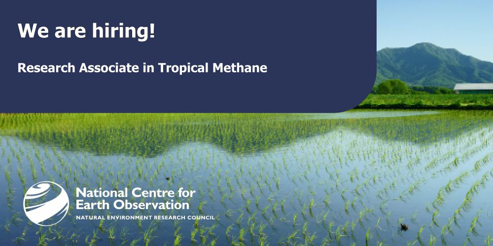
Join us as a Research Associate in Tropical Methane with the EOS group at Uni of Leicester🏛️
You will be working with @drrobparker.bsky.social team on a cutting-edge Environmental Digital Twin to study wetland methane & climate change🌍
📍 Apply by 4 May
🔗 tinyurl.com/mrxzkzya
#ClimateJobs #NCEO
You will be working with @drrobparker.bsky.social team on a cutting-edge Environmental Digital Twin to study wetland methane & climate change🌍
📍 Apply by 4 May
🔗 tinyurl.com/mrxzkzya
#ClimateJobs #NCEO
April 10, 2025 at 10:38 AM
Join us as a Research Associate in Tropical Methane with the EOS group at Uni of Leicester🏛️
You will be working with @drrobparker.bsky.social team on a cutting-edge Environmental Digital Twin to study wetland methane & climate change🌍
📍 Apply by 4 May
🔗 tinyurl.com/mrxzkzya
#ClimateJobs #NCEO
You will be working with @drrobparker.bsky.social team on a cutting-edge Environmental Digital Twin to study wetland methane & climate change🌍
📍 Apply by 4 May
🔗 tinyurl.com/mrxzkzya
#ClimateJobs #NCEO
Reposted by Andrew Cutts

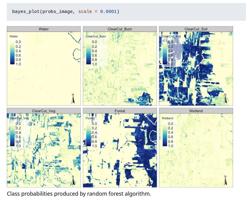
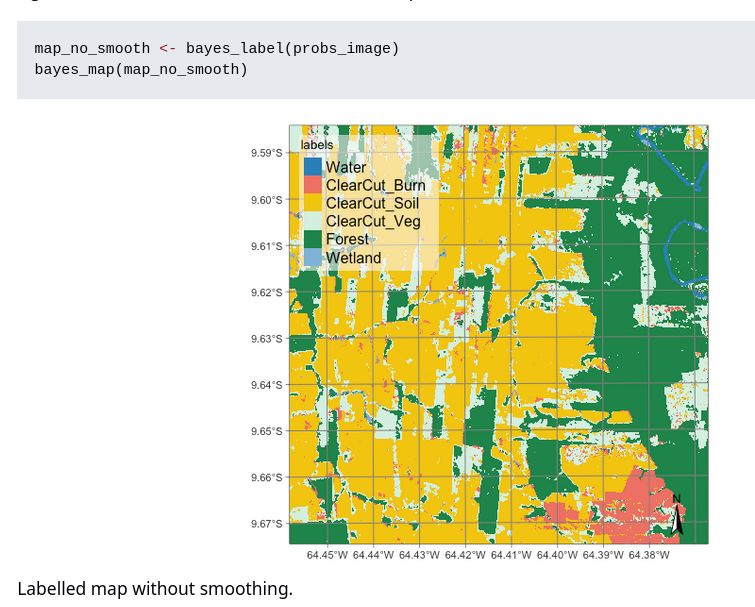
The bayesEO package provides a Bayesian approach to post-processing ML-generated images. It refines class probabilities, removes outliers, and improves labeling for more accurate classification.
🔗 https://github.com/e-sensing/bayesEO/
#rstats #machinelearning #remotesensing #bayesian #rspatial
🔗 https://github.com/e-sensing/bayesEO/
#rstats #machinelearning #remotesensing #bayesian #rspatial
March 30, 2025 at 4:05 PM
The bayesEO package provides a Bayesian approach to post-processing ML-generated images. It refines class probabilities, removes outliers, and improves labeling for more accurate classification.
🔗 https://github.com/e-sensing/bayesEO/
#rstats #machinelearning #remotesensing #bayesian #rspatial
🔗 https://github.com/e-sensing/bayesEO/
#rstats #machinelearning #remotesensing #bayesian #rspatial