


Live-On Tropics
@liveontropics.bsky.social
Cyclone Tracker | Weather Analyst | Youtuber
Trump: "UKRAINE 'LEADERSHIP' HAS EXPRESSED ZERO GRATITUDE."
Reality: a video of President Zelenskyy saying "thank you" to America 94 times went viral. One analysis counted at least 33 public thank yous to the U.S. and its citizens.
Some people only hear what they want to hear.
Reality: a video of President Zelenskyy saying "thank you" to America 94 times went viral. One analysis counted at least 33 public thank yous to the U.S. and its citizens.
Some people only hear what they want to hear.

November 23, 2025 at 2:30 PM
Trump: "UKRAINE 'LEADERSHIP' HAS EXPRESSED ZERO GRATITUDE."
Reality: a video of President Zelenskyy saying "thank you" to America 94 times went viral. One analysis counted at least 33 public thank yous to the U.S. and its citizens.
Some people only hear what they want to hear.
Reality: a video of President Zelenskyy saying "thank you" to America 94 times went viral. One analysis counted at least 33 public thank yous to the U.S. and its citizens.
Some people only hear what they want to hear.
Tomorrow could be a very active severe weather day across parts of Germany, Austria, Poland and Czechia, as huge areas could see damaging to even destructive winds, large hail and tornadoes. Worst case scenario could involve a derecho like system. #EUwx

June 3, 2025 at 7:45 AM
Tomorrow could be a very active severe weather day across parts of Germany, Austria, Poland and Czechia, as huge areas could see damaging to even destructive winds, large hail and tornadoes. Worst case scenario could involve a derecho like system. #EUwx
The National Hurricane Center has marked a new area of interest, it is very unlikely to become a (sub)tropical cyclone due to unfavourable conditions.

March 17, 2025 at 5:03 PM
The National Hurricane Center has marked a new area of interest, it is very unlikely to become a (sub)tropical cyclone due to unfavourable conditions.
As was well predicted, multiple cyclones ongoing in the Southern Hemisphere. 11S is the most concerning one in terms of land impacts, meanwhile 99S and 90S are likely to become powerful cyclones that are most likely to not affect land. #cyclone

February 1, 2025 at 10:10 AM
As was well predicted, multiple cyclones ongoing in the Southern Hemisphere. 11S is the most concerning one in terms of land impacts, meanwhile 99S and 90S are likely to become powerful cyclones that are most likely to not affect land. #cyclone
Look at all those possible scenarios over the Next week!!! Looks like a wild week ahead #cyclone #mauritius #lareunion #australia


January 30, 2025 at 5:58 AM
Look at all those possible scenarios over the Next week!!! Looks like a wild week ahead #cyclone #mauritius #lareunion #australia
The model output in regards to Storm Éowyn is frightening to say the least. Wind gusts approaching 120 mph ( 190 km/h ) along parts of coastal Ireland, huge areas under the risk of hurricane force gusts. Listen to official warning information!!! #StormÉowyn


January 22, 2025 at 3:58 PM
The model output in regards to Storm Éowyn is frightening to say the least. Wind gusts approaching 120 mph ( 190 km/h ) along parts of coastal Ireland, huge areas under the risk of hurricane force gusts. Listen to official warning information!!! #StormÉowyn
A threat from Storm Éowyn that few people have mentioned so far is thunderstorms. Note that relatively thin scattered line of rain behind the main bulk of it. Along that band it's probable we will see cold core thunderstorms, some of which could be tornadic. #StormÉowyn


January 22, 2025 at 3:52 PM
A threat from Storm Éowyn that few people have mentioned so far is thunderstorms. Note that relatively thin scattered line of rain behind the main bulk of it. Along that band it's probable we will see cold core thunderstorms, some of which could be tornadic. #StormÉowyn
A very interesting system has formed near Australia. Presenting an inner core feature on radar and good convection. Subtropical storm?

January 8, 2025 at 3:44 PM
A very interesting system has formed near Australia. Presenting an inner core feature on radar and good convection. Subtropical storm?
Dual tropical cyclones appear increasingly likely next week in the Indian Ocean, one is likely to impact India, Sri Lanka and Bangladesh, the other one is too far out away to predict any impacts.

November 23, 2024 at 7:23 PM
Dual tropical cyclones appear increasingly likely next week in the Indian Ocean, one is likely to impact India, Sri Lanka and Bangladesh, the other one is too far out away to predict any impacts.
Possible subtropical storm in the Eastern Pacific? Expected to head towards California. Second such case in the last month or so, we had one in late October. Coordinates: 40N 136W

November 23, 2024 at 7:21 PM
Possible subtropical storm in the Eastern Pacific? Expected to head towards California. Second such case in the last month or so, we had one in late October. Coordinates: 40N 136W
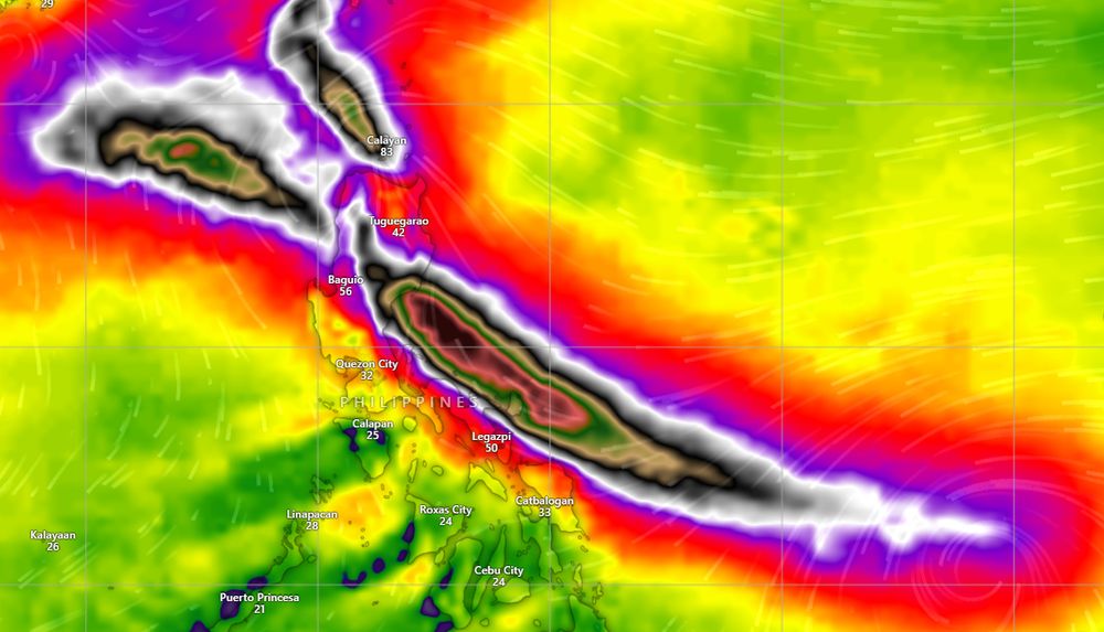
Typhoon #Man-yi is now a Category 5 according to JTWC analysis, signal 5 warnings have been issued by PAGASA. Even though there are signs of an EWRC which should weaken the storm, it will still be extremely impactful. Stay safe and listen to all warnings

November 16, 2024 at 8:04 AM
Typhoon #Man-yi is now a Category 5 according to JTWC analysis, signal 5 warnings have been issued by PAGASA. Even though there are signs of an EWRC which should weaken the storm, it will still be extremely impactful. Stay safe and listen to all warnings

#Typhoon #Man-yi is the most concerning system ongoing right now, with it likely at Category 3-4 strength at the moment. It is expeced to strike the #Philippines in about 24 hours with violent winds, torrential rain and storm surge, with impacts possible in #Hainan and #Vietnam later.


November 15, 2024 at 6:15 PM
#Typhoon #Man-yi is the most concerning system ongoing right now, with it likely at Category 3-4 strength at the moment. It is expeced to strike the #Philippines in about 24 hours with violent winds, torrential rain and storm surge, with impacts possible in #Hainan and #Vietnam later.
#Cyclone #Bheki has drastically improved in appearance in the last few hours, with it being a Category 1 at the moment. The system may become a Category 2 cyclone in a few days. The system is likely to reach Madagascar in about 6-7 days, albeit it will likely be way weaker by then.

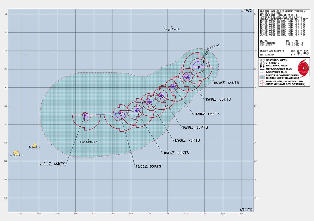
November 15, 2024 at 6:11 PM
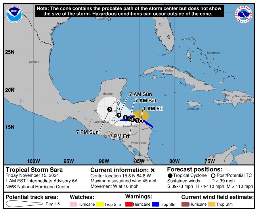
Tropical Storm SARA #Sara is moving along the coast of Honduras. Due to the slow movement of the system, it is expected to bring significant rainfall to Honduras and Belize over the next few days.

November 15, 2024 at 6:17 AM
Tropical Storm SARA #Sara is moving along the coast of Honduras. Due to the slow movement of the system, it is expected to bring significant rainfall to Honduras and Belize over the next few days.
Tropical Storm #Man-yi is the most concerning storm right now. It is intensifying, and likely to strike the Philippines as a powerful typhoon. Prepare now if you're in the path.

November 14, 2024 at 3:28 PM
Tropical Storm #Man-yi is the most concerning storm right now. It is intensifying, and likely to strike the Philippines as a powerful typhoon. Prepare now if you're in the path.
Typhoon #Usagi is weaker than it was just yesterday, but it still has a punch. The system is hitting the Batanes islands right now and expected to impact Taiwan later. The primary hazard there will be flooding, with over 10 in (250 mm) of rain in places.


November 14, 2024 at 3:20 PM
Typhoon #Usagi is weaker than it was just yesterday, but it still has a punch. The system is hitting the Batanes islands right now and expected to impact Taiwan later. The primary hazard there will be flooding, with over 10 in (250 mm) of rain in places.
Tropical Storm #Bheki has formed in the Southwest Indian Ocean. The system is expected to intensify over the next few days and could become a Category 1-2 equivalent cyclone. Forecast is highly uncertain, but impacts are possible in #Reunion, #Mauritius, #Rodrigues and #Madagascar


November 14, 2024 at 3:14 PM
Tropical Storm #Bheki has formed in the Southwest Indian Ocean. The system is expected to intensify over the next few days and could become a Category 1-2 equivalent cyclone. Forecast is highly uncertain, but impacts are possible in #Reunion, #Mauritius, #Rodrigues and #Madagascar
The new forecast for Tropical Depression 19 #TD19 indicates that the system will slow down significantly as it moves along the coast of Honduras. This is really bad, as it could cause extreme rainfall totals of over 30 in ( 750 mm) in some regions. Let's hope for the best.


November 14, 2024 at 2:58 PM
The new forecast for Tropical Depression 19 #TD19 indicates that the system will slow down significantly as it moves along the coast of Honduras. This is really bad, as it could cause extreme rainfall totals of over 30 in ( 750 mm) in some regions. Let's hope for the best.