


Jason J
@kc5knd.bsky.social
NWS Meteorologist/Master Instructor. Probabilistic forecasting, severe wx, radar, ML/AI, a little bit of this n that!
Playing with dynamical.org data in zarr format online (which is SUPER fast compared to downloading raw GEFS grib2 and converting locally. Why can't NWS do this???) Anyway, looking like Thanksgiving could be a bit chilly around these parts...all GEFS members 1st plot and quantiles/median second plot


November 12, 2025 at 11:16 PM
Playing with dynamical.org data in zarr format online (which is SUPER fast compared to downloading raw GEFS grib2 and converting locally. Why can't NWS do this???) Anyway, looking like Thanksgiving could be a bit chilly around these parts...all GEFS members 1st plot and quantiles/median second plot


#Aurora pretty much gone here from DEN metro. So was this the initial X1 CME hit or did the X5 CME catch up and surprise us all? Guess I’ll have to set an hourly alarm to look out the window to make sure there aren’t any more substorms tonight and swing by SWPC tomorrow morning for insight. #cowx
November 12, 2025 at 3:01 AM

Cruddy screenshot from my Cloud AWIPS system but in my 30+ years of meteorology experience, the data coming out of #Melissa is nothing short of incredible, and deeply saddening. Jamaica will be in rough shape after this for a long time to come…

October 28, 2025 at 3:15 PM
Cruddy screenshot from my Cloud AWIPS system but in my 30+ years of meteorology experience, the data coming out of #Melissa is nothing short of incredible, and deeply saddening. Jamaica will be in rough shape after this for a long time to come…
Enderlin, ND tor #1 from 20 June 2025 upgraded to EF-5. A good reminder that 1) post-event analyses take time & 2) external expert opinion is invaluable. Having been on EF-5 surveys, seemingly small details can make big difference (i.e. tree damage)
mesonet.agron.iastate.edu/wx/afos/p.ph...
mesonet.agron.iastate.edu/wx/afos/p.ph...

IEM :: PNS from NWS FGF
PNS issued by NWS FGF at 06 Oct 2025 14:30 UTC
mesonet.agron.iastate.edu
October 6, 2025 at 2:50 PM
Enderlin, ND tor #1 from 20 June 2025 upgraded to EF-5. A good reminder that 1) post-event analyses take time & 2) external expert opinion is invaluable. Having been on EF-5 surveys, seemingly small details can make big difference (i.e. tree damage)
mesonet.agron.iastate.edu/wx/afos/p.ph...
mesonet.agron.iastate.edu/wx/afos/p.ph...
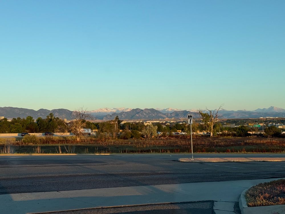
Winter is coming (but taking a hiatus for the next week according to the ensembles). Snow on the Front Range peaks, but not on the Flatirons. #cowx #snowseason (full disclosure; Apple AI helped remove cars on US 36; stop & go traffic on Davidson Mesa brought you this pic)

September 24, 2025 at 1:40 PM
Winter is coming (but taking a hiatus for the next week according to the ensembles). Snow on the Front Range peaks, but not on the Flatirons. #cowx #snowseason (full disclosure; Apple AI helped remove cars on US 36; stop & go traffic on Davidson Mesa brought you this pic)
Folks around McCook, Nebraska are going to have a free ice cold swimming pool; storm and occasional supercell parked just north of the surface frontal boundary dropping 3” hail and radar estimates pushing 4” of rain… #newx
September 16, 2025 at 9:34 PM
Folks around McCook, Nebraska are going to have a free ice cold swimming pool; storm and occasional supercell parked just north of the surface frontal boundary dropping 3” hail and radar estimates pushing 4” of rain… #newx
It’s hard to see but that is an Extreme Forecast Index of 0.5 off the coast of SoCal late week. The black lines are Shift of Tails…of over 8 (contour maxes out at 8). NWS EFI/SoT (firewalled) shows greater than 10 SoT! 😳 Chance for extreme precip is medium but could be extreme w/ high SoT values!

September 15, 2025 at 2:18 PM
It’s hard to see but that is an Extreme Forecast Index of 0.5 off the coast of SoCal late week. The black lines are Shift of Tails…of over 8 (contour maxes out at 8). NWS EFI/SoT (firewalled) shows greater than 10 SoT! 😳 Chance for extreme precip is medium but could be extreme w/ high SoT values!
Interesting sky this morning heading into work. We’re almost to the right time of year when I’ll be heading out when there will be more colors (you know, to avoid the morning CU BOU student rush hour to get there just in time for their first class). #cowx

September 10, 2025 at 1:40 PM
Interesting sky this morning heading into work. We’re almost to the right time of year when I’ll be heading out when there will be more colors (you know, to avoid the morning CU BOU student rush hour to get there just in time for their first class). #cowx
Great morning to make the bike ride on Big Dry Creek trail from City Park to Standley Lake. Some spots felt in the 40s along creek drainage which was great until I climbed out the last 1.5 miles up to the lake. That was a bit warm in full sun & out of the cold air drainage. 12.72 mi round trip


September 1, 2025 at 4:56 PM
Great morning to make the bike ride on Big Dry Creek trail from City Park to Standley Lake. Some spots felt in the 40s along creek drainage which was great until I climbed out the last 1.5 miles up to the lake. That was a bit warm in full sun & out of the cold air drainage. 12.72 mi round trip
Xcel Energy is changing TOU rate structure in October. Gone is Mid-Peak 1-3pm and Peak moves from 3-7pm to 5-9pm. So as a good data scientist does, spent the last 2 hours in Python with my 2024 hourly net metering data & found out that my change in cost would have been...$2.18. For the year.
August 23, 2025 at 5:04 PM
Xcel Energy is changing TOU rate structure in October. Gone is Mid-Peak 1-3pm and Peak moves from 3-7pm to 5-9pm. So as a good data scientist does, spent the last 2 hours in Python with my 2024 hourly net metering data & found out that my change in cost would have been...$2.18. For the year.
Yeah, it’s the 95th Percentile from NBM V5.0 and 10 days out…but it is still a chance for snow! #winteriscoming #wishcasting

August 22, 2025 at 3:01 PM
Yeah, it’s the 95th Percentile from NBM V5.0 and 10 days out…but it is still a chance for snow! #winteriscoming #wishcasting
Reposted by Jason J

Numerical weather prediction models (ECMWF IFS) still outperform AI weather models in forecasting record-breaking hot and cold extremes and unseen wind extremes
Preprint
arxiv.org/abs/2508.15724
with Zhongwei Zhang @erichfischer.bsky.social @zscheischlerjak.bsky.social and Sebastian Engelke
Preprint
arxiv.org/abs/2508.15724
with Zhongwei Zhang @erichfischer.bsky.social @zscheischlerjak.bsky.social and Sebastian Engelke

Numerical models outperform AI weather forecasts of record-breaking extremes
Artificial intelligence (AI)-based models are revolutionizing weather forecasting and have surpassed leading numerical weather prediction systems on various benchmark tasks. However, their ability to ...
arxiv.org
August 22, 2025 at 5:43 AM
Numerical weather prediction models (ECMWF IFS) still outperform AI weather models in forecasting record-breaking hot and cold extremes and unseen wind extremes
Preprint
arxiv.org/abs/2508.15724
with Zhongwei Zhang @erichfischer.bsky.social @zscheischlerjak.bsky.social and Sebastian Engelke
Preprint
arxiv.org/abs/2508.15724
with Zhongwei Zhang @erichfischer.bsky.social @zscheischlerjak.bsky.social and Sebastian Engelke
The HRRR smoke forecasts were bad on the 00Z and 12Z runs; smoke settled into Vail Valley so we “cheated” and drove up to the Shrine Pass lot. Made it up to 11.9 kft today and it was worth it; smoke was not bad above the inversion, it was cool, & the last of the wildflowers were in bloom. #colorado


August 9, 2025 at 10:06 PM
The HRRR smoke forecasts were bad on the 00Z and 12Z runs; smoke settled into Vail Valley so we “cheated” and drove up to the Shrine Pass lot. Made it up to 11.9 kft today and it was worth it; smoke was not bad above the inversion, it was cool, & the last of the wildflowers were in bloom. #colorado


So many takes (good & bad) on the TX Hill Country flooding. Having spent a large part of my life in the heart of Hill Country, difference of 5 miles or less can mean soaking rain or flash flood. Look at hydromet.lcra.org precip & stream flow; you can see what I mean (basins are shaded in these maps)


July 13, 2025 at 3:47 PM
So many takes (good & bad) on the TX Hill Country flooding. Having spent a large part of my life in the heart of Hill Country, difference of 5 miles or less can mean soaking rain or flash flood. Look at hydromet.lcra.org precip & stream flow; you can see what I mean (basins are shaded in these maps)
Reposted by Jason J
"Questioning is the way of learning,"
Encourage your children to ask questions, not to accept existing answers.
Encourage your children to ask questions, not to accept existing answers.
July 13, 2025 at 2:20 PM
"Questioning is the way of learning,"
Encourage your children to ask questions, not to accept existing answers.
Encourage your children to ask questions, not to accept existing answers.


A 300x timelapse from my neighbor; “You study clouds, what is this stuff before sunrise? We saw it when we went to let (dog’s name) out…”
Sure looks like noctilucent clouds to me! #cowx #noctilucent
Sure looks like noctilucent clouds to me! #cowx #noctilucent
July 11, 2025 at 12:16 PM
A 300x timelapse from my neighbor; “You study clouds, what is this stuff before sunrise? We saw it when we went to let (dog’s name) out…”
Sure looks like noctilucent clouds to me! #cowx #noctilucent
Sure looks like noctilucent clouds to me! #cowx #noctilucent