


@justincat66.bsky.social
Mississippi State Broadcast/Operational Meteorology student and passionate weather activist/enthusiast. MN Sports plus Mississippi State fan.
#MSP and #TwinCities friends, yes we’ve got more snow on the way tomorrow (Friday December 5th)
Expect snow to break out right around sunrise and last most of the day. I could see some half inch+/hr snowfall rates at times, which is reasonable based on the current returns in the Dakotas…
Expect snow to break out right around sunrise and last most of the day. I could see some half inch+/hr snowfall rates at times, which is reasonable based on the current returns in the Dakotas…


December 5, 2025 at 2:58 AM
#MSP and #TwinCities friends, yes we’ve got more snow on the way tomorrow (Friday December 5th)
Expect snow to break out right around sunrise and last most of the day. I could see some half inch+/hr snowfall rates at times, which is reasonable based on the current returns in the Dakotas…
Expect snow to break out right around sunrise and last most of the day. I could see some half inch+/hr snowfall rates at times, which is reasonable based on the current returns in the Dakotas…
00z MPX observed sounding shows a clear dry slot from 700-850mb as was expected by the forecast soundings. Until that column saturates a lot more, there will not be snow in the #TwinCities metro.

November 29, 2025 at 12:58 AM
00z MPX observed sounding shows a clear dry slot from 700-850mb as was expected by the forecast soundings. Until that column saturates a lot more, there will not be snow in the #TwinCities metro.
❄️Winter Storm Potential: Friday November 28th-Monday December 1st
Confidence is beginning to increase on a potentially significant winter storm next weekend from portions of the #Plains into the #Midwest and #UpperMidwest. The cold air is coming around or just after Thanksgiving, and that will…
Confidence is beginning to increase on a potentially significant winter storm next weekend from portions of the #Plains into the #Midwest and #UpperMidwest. The cold air is coming around or just after Thanksgiving, and that will…


November 21, 2025 at 12:03 PM
❄️Winter Storm Potential: Friday November 28th-Monday December 1st
Confidence is beginning to increase on a potentially significant winter storm next weekend from portions of the #Plains into the #Midwest and #UpperMidwest. The cold air is coming around or just after Thanksgiving, and that will…
Confidence is beginning to increase on a potentially significant winter storm next weekend from portions of the #Plains into the #Midwest and #UpperMidwest. The cold air is coming around or just after Thanksgiving, and that will…
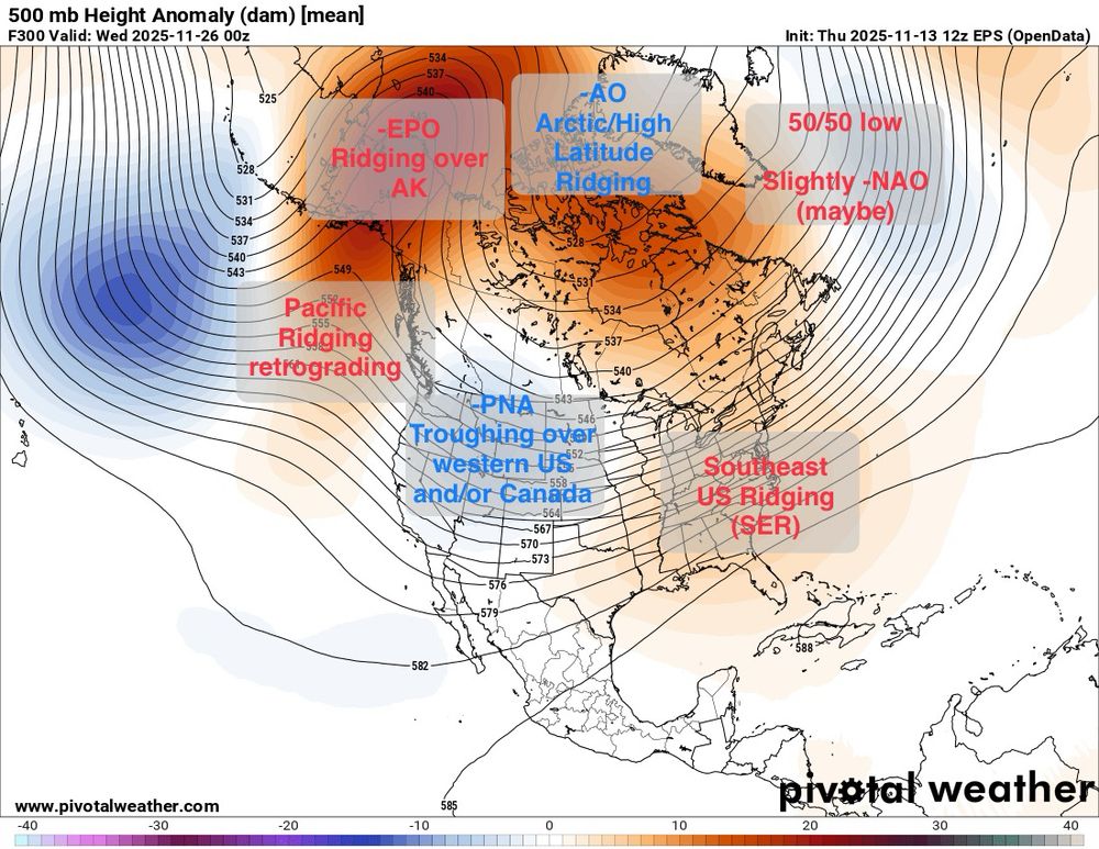
On the 12z CMCE, a more stronger -EPO and stronger -PNA as a result would support a further S storm track, putting our snowstorm risk possibly more into the C to maybe S Plains into the Great Lakes and our severe weather risk more into Dixie Alley, into the OH/TN Valleys into the southeast US

November 14, 2025 at 3:21 AM
On the 12z CMCE, a more stronger -EPO and stronger -PNA as a result would support a further S storm track, putting our snowstorm risk possibly more into the C to maybe S Plains into the Great Lakes and our severe weather risk more into Dixie Alley, into the OH/TN Valleys into the southeast US
Looking at the other two ensembles, there is a similar idea presented. On the 18z GEFS solution, snowstorm potential looks higher across the Rockies/N Plains and Upper Midwest region, with Severe thunderstorm potential higher across the S Plains and possibly portions of Dixie Alley

November 14, 2025 at 3:21 AM
Looking at the other two ensembles, there is a similar idea presented. On the 18z GEFS solution, snowstorm potential looks higher across the Rockies/N Plains and Upper Midwest region, with Severe thunderstorm potential higher across the S Plains and possibly portions of Dixie Alley
As we move into Late November, right around Thanksgiving timeframe, our pattern is likely going to undergo more significant changes. A -EPO/-AO/-PNA combination as well as possibly a -NAO and the Pacific ridge retracting a bit should allow a substantial increase in upper lvl energy across the west.
November 14, 2025 at 3:21 AM
As we move into Late November, right around Thanksgiving timeframe, our pattern is likely going to undergo more significant changes. A -EPO/-AO/-PNA combination as well as possibly a -NAO and the Pacific ridge retracting a bit should allow a substantial increase in upper lvl energy across the west.
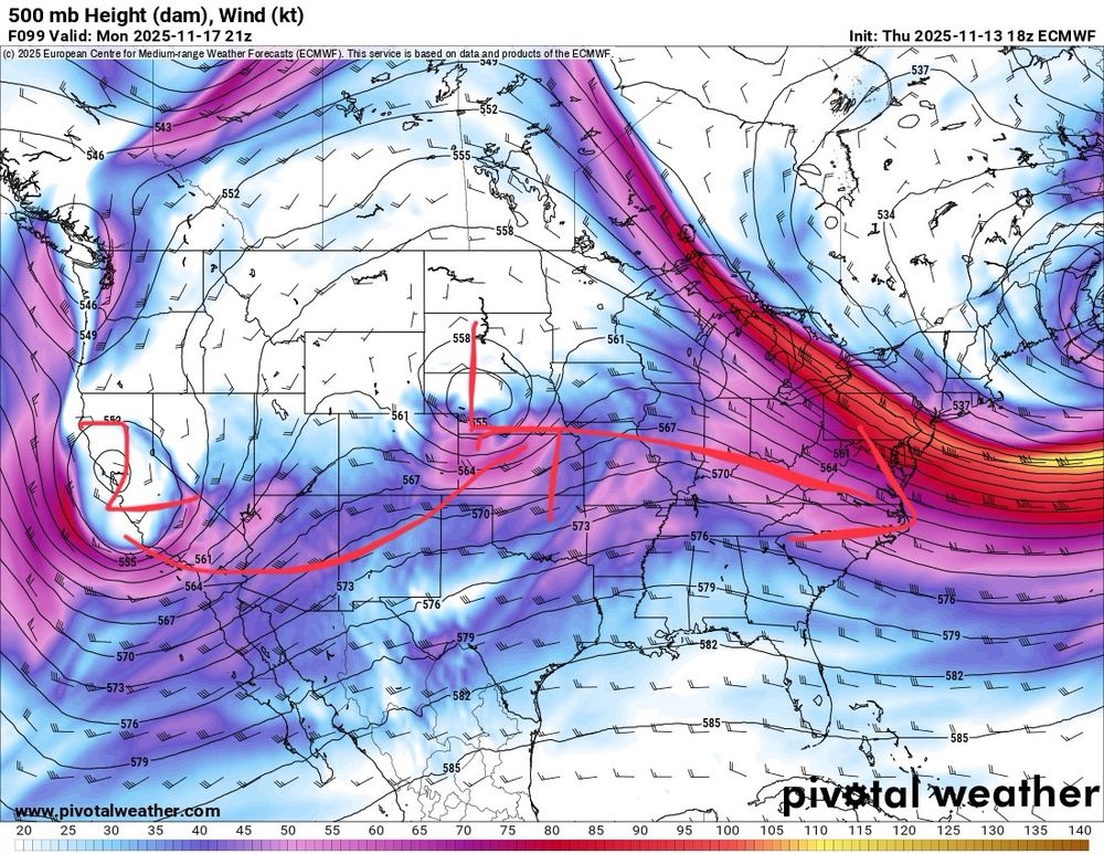
However as we near the middle to especially end of next week, things should start ramping up significantly. Our 2nd trough should start ejecting across the central portion of the country, and overlapping with increasing Gulf moisture.


November 14, 2025 at 3:21 AM
However as we near the middle to especially end of next week, things should start ramping up significantly. Our 2nd trough should start ejecting across the central portion of the country, and overlapping with increasing Gulf moisture.
As we move into early next week, a series of troughs/storm systems will eject, first across the western US, then eventually into the central and maybe portions of the eastern US. My current thinking is the Arctic ridging/blocking will lead to the first system deamplifying…
November 14, 2025 at 3:21 AM
As we move into early next week, a series of troughs/storm systems will eject, first across the western US, then eventually into the central and maybe portions of the eastern US. My current thinking is the Arctic ridging/blocking will lead to the first system deamplifying…
Probably my best images of the night so far from the #aurora #northernlights in western #Wisconsin. Taken at about 9:20pm CST


November 12, 2025 at 3:37 AM
Probably my best images of the night so far from the #aurora #northernlights in western #Wisconsin. Taken at about 9:20pm CST
Couple more #aurora #northernlights photos from western #Wisconsin tonight. Unreal show and I’ve seen a lot these past few years


November 12, 2025 at 3:06 AM
Couple more #aurora #northernlights photos from western #Wisconsin tonight. Unreal show and I’ve seen a lot these past few years
Couple of the photos from the #aurora #northernlights in western WI tonight
Likely will try another round at some point but thankful that the clouds cleared out
Likely will try another round at some point but thankful that the clouds cleared out


November 12, 2025 at 2:06 AM
Couple of the photos from the #aurora #northernlights in western WI tonight
Likely will try another round at some point but thankful that the clouds cleared out
Likely will try another round at some point but thankful that the clouds cleared out
Heads up to my #Minnesota, #Wisconsin and people in other surrounding states as the wind chill forecasts Sunday morning through Monday evening looks pretty brutal for early to mid November. You will need an extra layer and bundles if you’re going out. #mnwx #wiwx #ndwx #sdwx #iawx #newx


November 7, 2025 at 3:14 AM
Heads up to my #Minnesota, #Wisconsin and people in other surrounding states as the wind chill forecasts Sunday morning through Monday evening looks pretty brutal for early to mid November. You will need an extra layer and bundles if you’re going out. #mnwx #wiwx #ndwx #sdwx #iawx #newx
Currently all of the ensemble guidance clearly shows a flip to a -PNA west troughing with an east ridge combo. If this verifies, this should not only lead to a more active pattern across the western to central US, but these systems should have more cold air available to them as well.


October 31, 2025 at 9:22 PM
Currently all of the ensemble guidance clearly shows a flip to a -PNA west troughing with an east ridge combo. If this verifies, this should not only lead to a more active pattern across the western to central US, but these systems should have more cold air available to them as well.
Eventually, likely by the end of next week to next weekend. One or mutiple troughs from the Pacific may be able to penetrate eastward. This could lead to one or mutiple storm systems, although specifics are still a little murky at this time. However because of the Pacific jet extension, I am…


October 31, 2025 at 9:22 PM
Eventually, likely by the end of next week to next weekend. One or mutiple troughs from the Pacific may be able to penetrate eastward. This could lead to one or mutiple storm systems, although specifics are still a little murky at this time. However because of the Pacific jet extension, I am…
In the middle to latter portion of next week, I’d expect a big warmup across most of the CONUS as our Pacific jet extension takes over. This will provide an overwhelming portion of the country with westerlies and warm mild Pacific air


October 31, 2025 at 9:22 PM
In the middle to latter portion of next week, I’d expect a big warmup across most of the CONUS as our Pacific jet extension takes over. This will provide an overwhelming portion of the country with westerlies and warm mild Pacific air
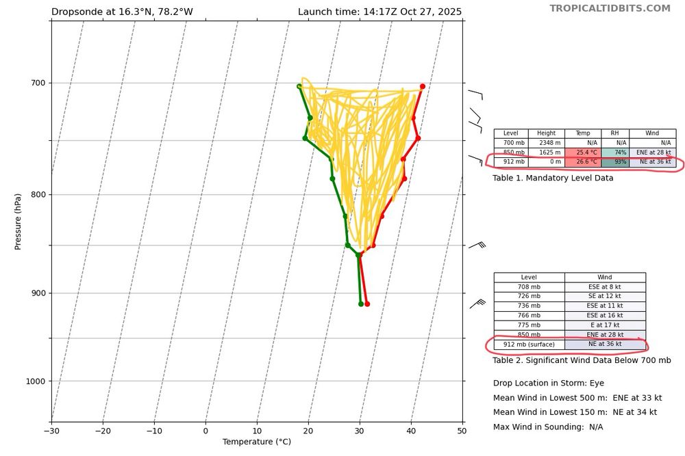
The newest Dropsonde is absolute mind boggling, and might be the craziest Dropsonde I have ever seen in a hurricane. We have sustained winds of 163kts recorded at the sfc but not even 10mb off the surface, there are almost 200kts of winds. Even if we count this as a gust, that is ultra impressive

October 27, 2025 at 4:40 PM
The newest Dropsonde is absolute mind boggling, and might be the craziest Dropsonde I have ever seen in a hurricane. We have sustained winds of 163kts recorded at the sfc but not even 10mb off the surface, there are almost 200kts of winds. Even if we count this as a gust, that is ultra impressive
As expected the NHC is using very dire wording that rivals some of the most powerful landfalling hurricanes the Atlantic basin has ever seen. This will be a historic and unprecended event for #Jamaica and prayers go out to everyone there who have a extremely rough next 24-48 hrs ahead

October 27, 2025 at 4:02 PM
As expected the NHC is using very dire wording that rivals some of the most powerful landfalling hurricanes the Atlantic basin has ever seen. This will be a historic and unprecended event for #Jamaica and prayers go out to everyone there who have a extremely rough next 24-48 hrs ahead
Mutiple dropsondes from the hurricane hunters show this idea very clearly. In the SE eyewall sustained winds were found to be 137kts, but not even 30mb off the surface, there were winds of up over 160kts recorded. There was also a clear temperature spike and a pressure of 908-909mb found in the eye

October 27, 2025 at 4:02 PM
Mutiple dropsondes from the hurricane hunters show this idea very clearly. In the SE eyewall sustained winds were found to be 137kts, but not even 30mb off the surface, there were winds of up over 160kts recorded. There was also a clear temperature spike and a pressure of 908-909mb found in the eye
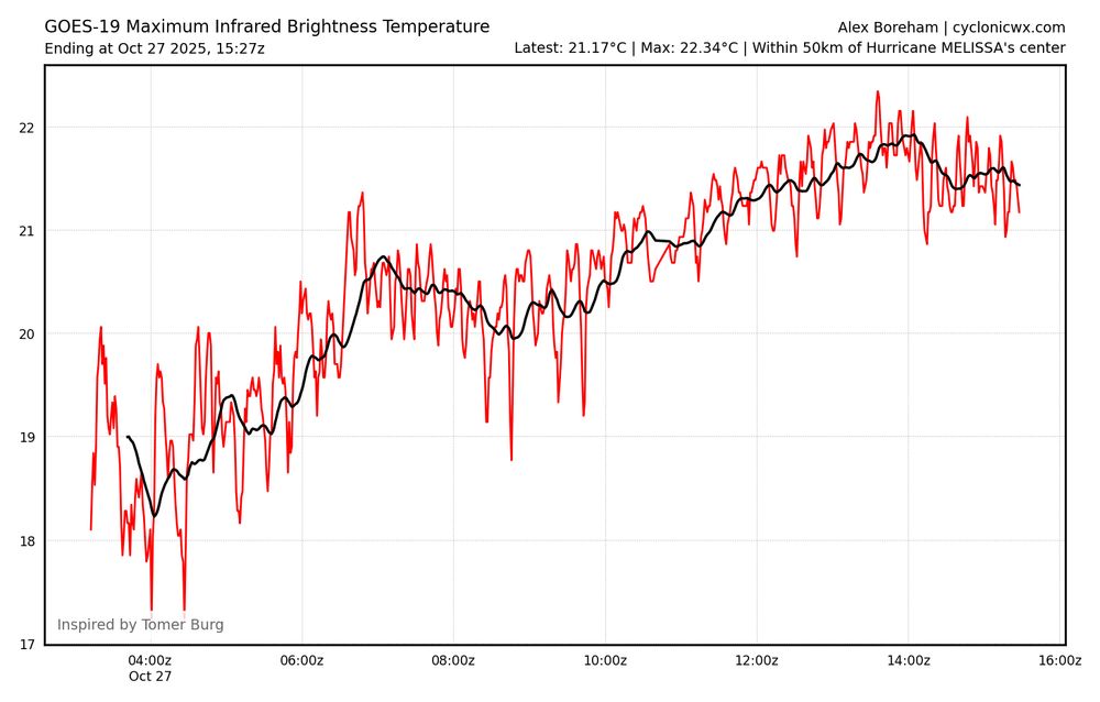
Both the average WV and IR temperatures has been warming fast over the past 12 hrs, indicating a very healthy system. The more warming/sinking air and subsidence there is in the eye, the more latent heat is being released from the intense thunderstorms in the core of Melissa, lowering sfc pressures

October 27, 2025 at 4:02 PM
Both the average WV and IR temperatures has been warming fast over the past 12 hrs, indicating a very healthy system. The more warming/sinking air and subsidence there is in the eye, the more latent heat is being released from the intense thunderstorms in the core of Melissa, lowering sfc pressures
Hurricane #Melissa has rapidly intensified into a Category 5 hurricane with peak winds this morning reaching as high as 165mph. Absolute textbook IR and WV imagery showing a very circular clear eye with intense thunderstorm activity all the way around the core and clear UL outflow channels to the N.


October 27, 2025 at 4:02 PM
Hurricane #Melissa has rapidly intensified into a Category 5 hurricane with peak winds this morning reaching as high as 165mph. Absolute textbook IR and WV imagery showing a very circular clear eye with intense thunderstorm activity all the way around the core and clear UL outflow channels to the N.
It also has to be mentioned that this could be a potentially catastrophic strike for #Jamaica or portions of #Cuba. Not only could you see a major hurricane landfall but the rainfall amounts espcially combined with terrain enhancement could lead to catastrophic flooding impacts.


October 24, 2025 at 6:32 PM
Melissa should slowly drift W the next few days as a weak ridge builds in to the N. Eventually by early to mid next week, a turn to the N and eventually NE is expected ad another mid latitude system from our western US atmospheric river weakens the ridge again.

October 24, 2025 at 6:32 PM
Melissa should slowly drift W the next few days as a weak ridge builds in to the N. Eventually by early to mid next week, a turn to the N and eventually NE is expected ad another mid latitude system from our western US atmospheric river weakens the ridge again.
Melissa will likely continue this rapid to significant intensification trend under this environment with extremely warm and very deep warm waters that is untapped this season over the next few days. All of the forecast guidance shows this idea


October 24, 2025 at 6:32 PM
Melissa will likely continue this rapid to significant intensification trend under this environment with extremely warm and very deep warm waters that is untapped this season over the next few days. All of the forecast guidance shows this idea
Tropical Storm #Melissa appears to be the process of beginning significant to rapid intensification as the wind shear that has been keeping the storm in check begins to back off. Overall the CDO structure is much better and the UL outflow is looking much healthier now #weather #tropicalwx
October 24, 2025 at 6:32 PM
Tropical Storm #Melissa appears to be the process of beginning significant to rapid intensification as the wind shear that has been keeping the storm in check begins to back off. Overall the CDO structure is much better and the UL outflow is looking much healthier now #weather #tropicalwx
Finally there will likely be some low level winds, which may increase the turning of the winds, both speed and directional wise for tornadoes. There are still some speed among the models that needs to be worked out, but Saturday is a day to watch for an all hazards severe risk.

October 13, 2025 at 9:53 AM
Finally there will likely be some low level winds, which may increase the turning of the winds, both speed and directional wise for tornadoes. There are still some speed among the models that needs to be worked out, but Saturday is a day to watch for an all hazards severe risk.