


Jonathan Wille
@jonathanwille.bsky.social
❄️ Polar meteorologist and climatologist.
Studying #polar #meteorology #climatology with focus on atmospheric rivers, mass balance impacts, and high-res climate modeling.
Post-doc researcher at ETH Zurich.
Studying #polar #meteorology #climatology with focus on atmospheric rivers, mass balance impacts, and high-res climate modeling.
Post-doc researcher at ETH Zurich.
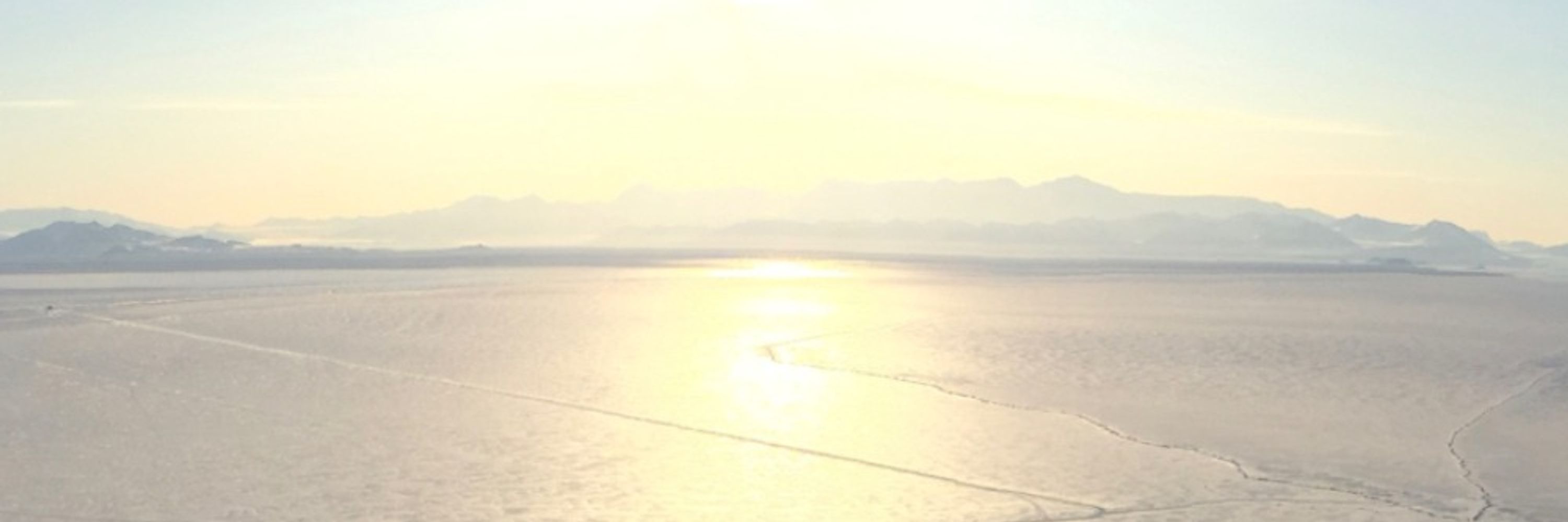
Latest update from the National Hurricane Center for hurricane Melissa right before it makes landfall in western Jamaica. Winds are 185 mph with a 892 mb pressure making it the third strongest Atlantic hurricane ever by pressure. The destruction that is about to happen is just unimaginable.

October 28, 2025 at 2:11 PM
Latest update from the National Hurricane Center for hurricane Melissa right before it makes landfall in western Jamaica. Winds are 185 mph with a 892 mb pressure making it the third strongest Atlantic hurricane ever by pressure. The destruction that is about to happen is just unimaginable.
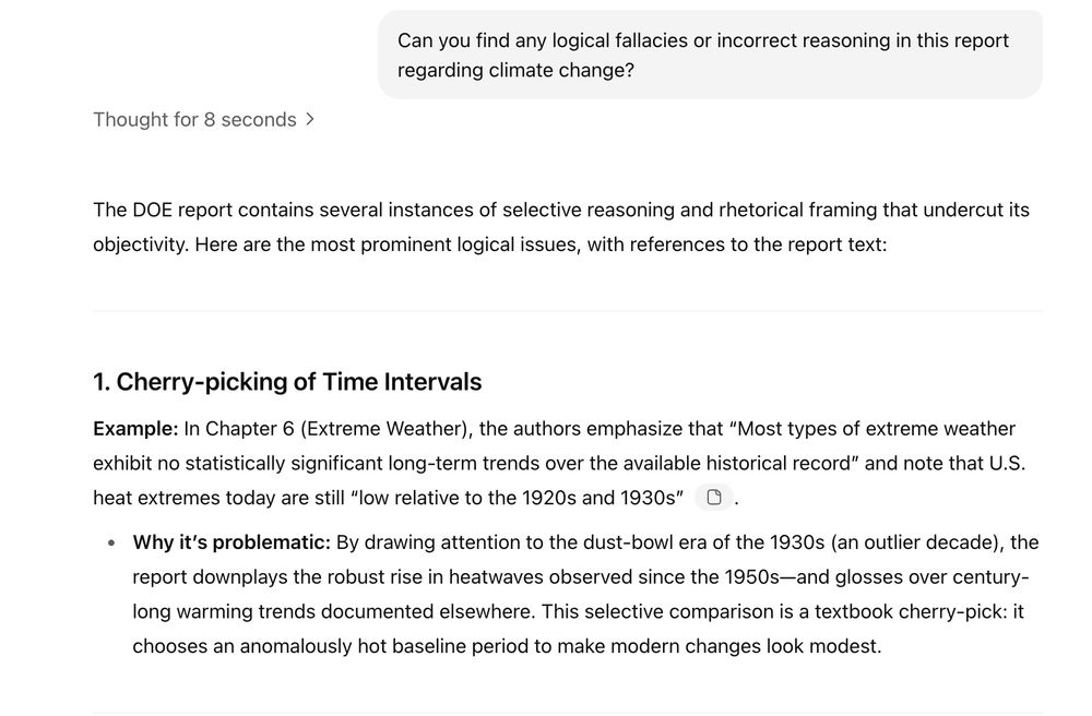
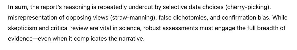
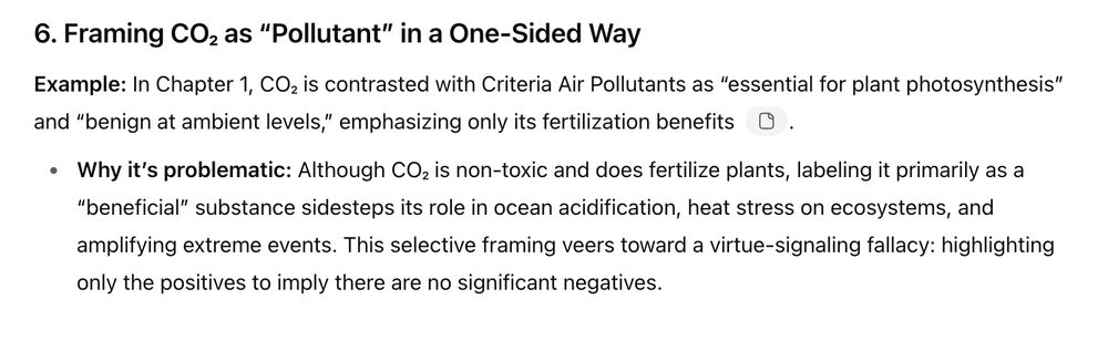
A report from the Climate Working Group commissioned by the DOE is the scientific basis for the EPA's proposal to revoke the 2009 Endangerment Finding. This report, written by well-known climate skeptic scientists, is absolutely insulting to read from a science writing perspective. 🧵
July 30, 2025 at 12:23 PM
A report from the Climate Working Group commissioned by the DOE is the scientific basis for the EPA's proposal to revoke the 2009 Endangerment Finding. This report, written by well-known climate skeptic scientists, is absolutely insulting to read from a science writing perspective. 🧵
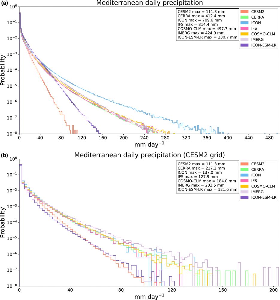
Finally, looking at the global daily dry fraction on a common, coarse resolution, the differences between the models is diminished suggesting that resolution is the main driver of improvements. One big theme though is the difficulty of validating extreme precipitation with Obs and reanalysis.
July 15, 2025 at 9:50 AM
Finally, looking at the global daily dry fraction on a common, coarse resolution, the differences between the models is diminished suggesting that resolution is the main driver of improvements. One big theme though is the difficulty of validating extreme precipitation with Obs and reanalysis.
One possible culprit is the missing connection between moisture convergence and extreme precipitation in ICON. The lack of convection parameterization means ICON generates more bubbly, isolated convective cells instead of organized precipitation along frontal boundaries
July 15, 2025 at 9:50 AM
One possible culprit is the missing connection between moisture convergence and extreme precipitation in ICON. The lack of convection parameterization means ICON generates more bubbly, isolated convective cells instead of organized precipitation along frontal boundaries
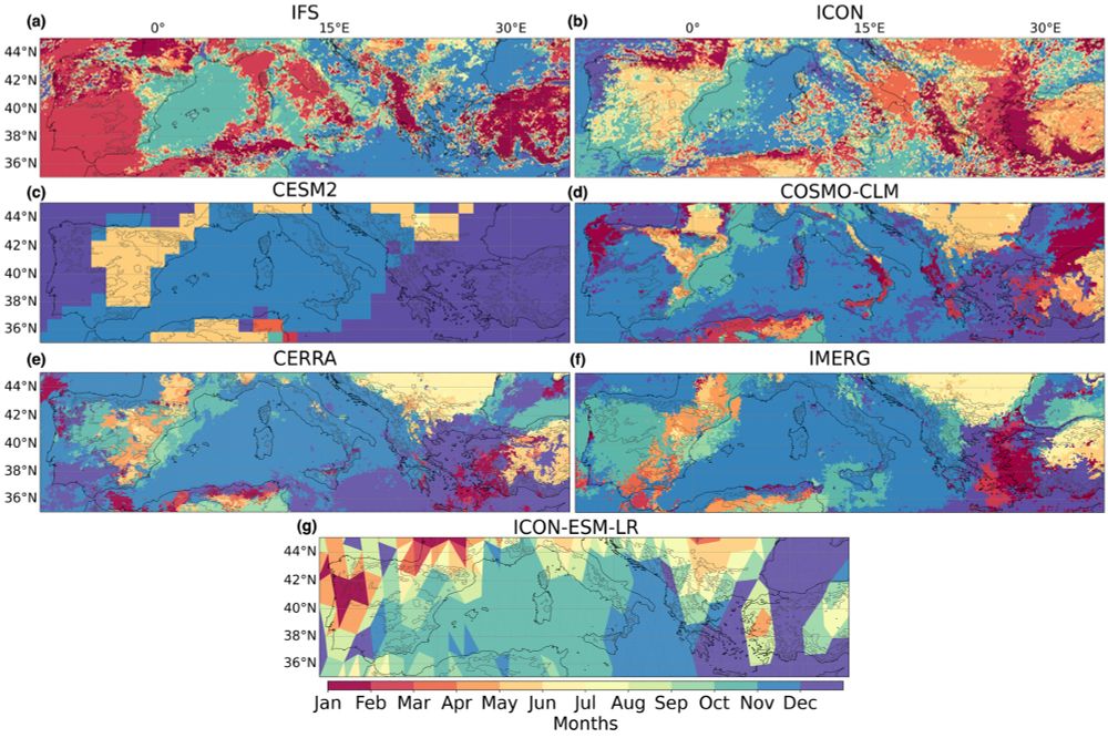
To better understand what factors drive precipitation patterns in the models, we looked at which month contains the most extreme rainfall. Normally autumn is the primary time for extreme weather in the Mediterranean, but ICON misses this meaning a less consistent extreme precipitation forcing
July 15, 2025 at 9:50 AM
To better understand what factors drive precipitation patterns in the models, we looked at which month contains the most extreme rainfall. Normally autumn is the primary time for extreme weather in the Mediterranean, but ICON misses this meaning a less consistent extreme precipitation forcing
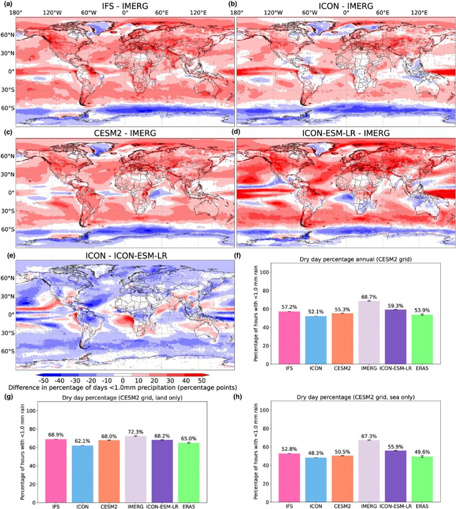
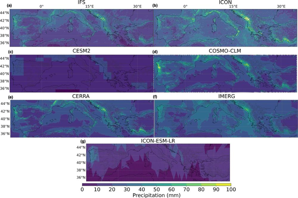
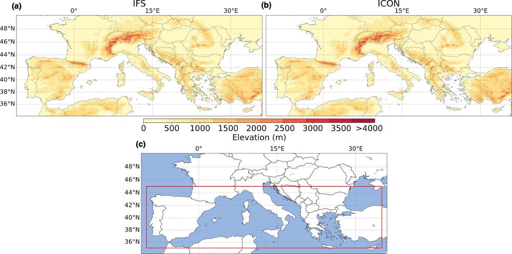
The benefits of higher resolution are seen again in the 95th quantile of daily precipitation where IFS and ICON show higher rainfall values in mountainous terrain.
July 15, 2025 at 9:50 AM
The benefits of higher resolution are seen again in the 95th quantile of daily precipitation where IFS and ICON show higher rainfall values in mountainous terrain.
Moving to the high-tail end of precipitation extremes, IFS produced very high, yet reasonable values of extreme rainfall. When controlling for resolution, this improvement over CESM2 persists for both IFS and ICON. This is important for having a climate model directly simulate flooding rains.
July 15, 2025 at 9:50 AM
Moving to the high-tail end of precipitation extremes, IFS produced very high, yet reasonable values of extreme rainfall. When controlling for resolution, this improvement over CESM2 persists for both IFS and ICON. This is important for having a climate model directly simulate flooding rains.
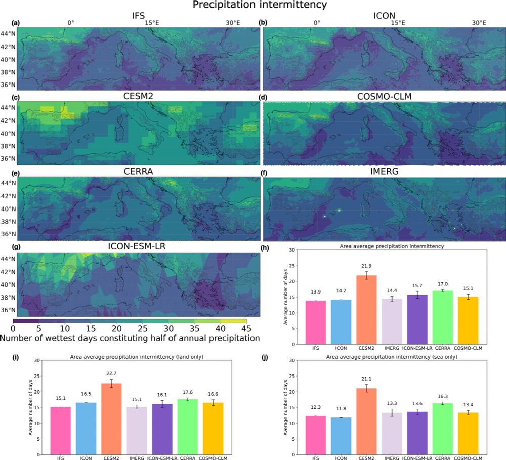
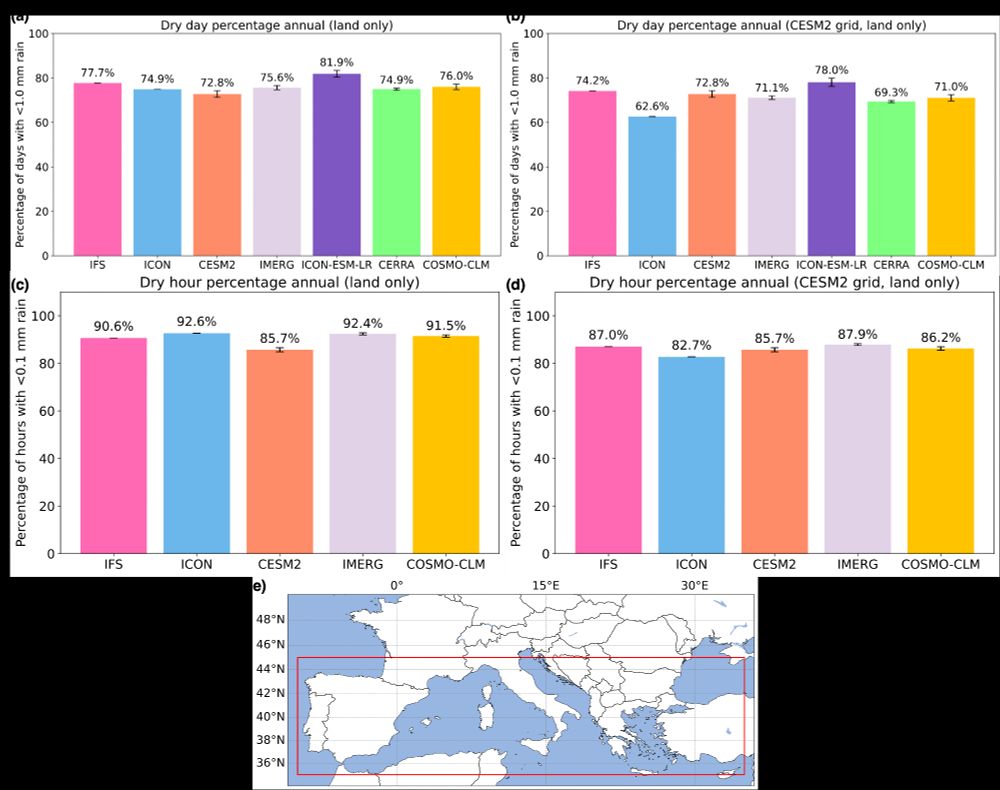
Precipitation intermittency represents how precipitation is distributed during the year. Is it light and frequent, or intense and rare? Here IFS and ICON show clear improvements over the CESM2 which has too diffuse precipitation leading to the common "drizzle bias"
July 15, 2025 at 9:50 AM
Precipitation intermittency represents how precipitation is distributed during the year. Is it light and frequent, or intense and rare? Here IFS and ICON show clear improvements over the CESM2 which has too diffuse precipitation leading to the common "drizzle bias"
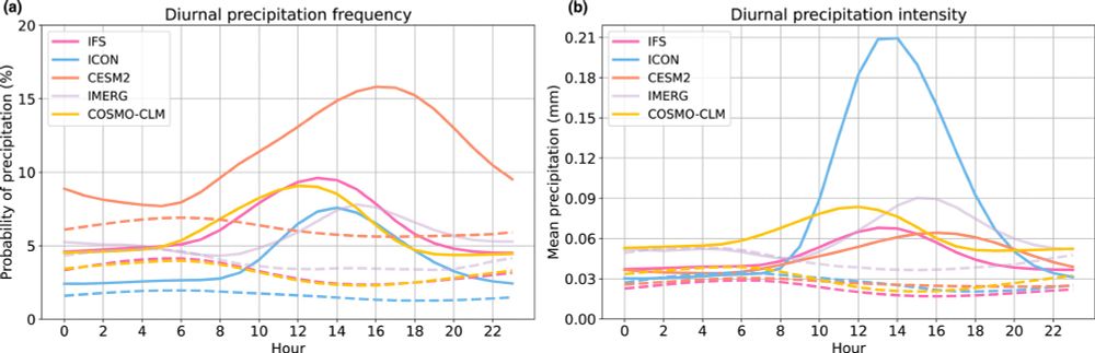
We know that ICON has no convection parameterization which leads allows it to produce more convective showers and thunderstorms, thus breaking up the dry spells over land. But this also causes the afternoon storms to be far too intense.
July 15, 2025 at 9:50 AM
We know that ICON has no convection parameterization which leads allows it to produce more convective showers and thunderstorms, thus breaking up the dry spells over land. But this also causes the afternoon storms to be far too intense.
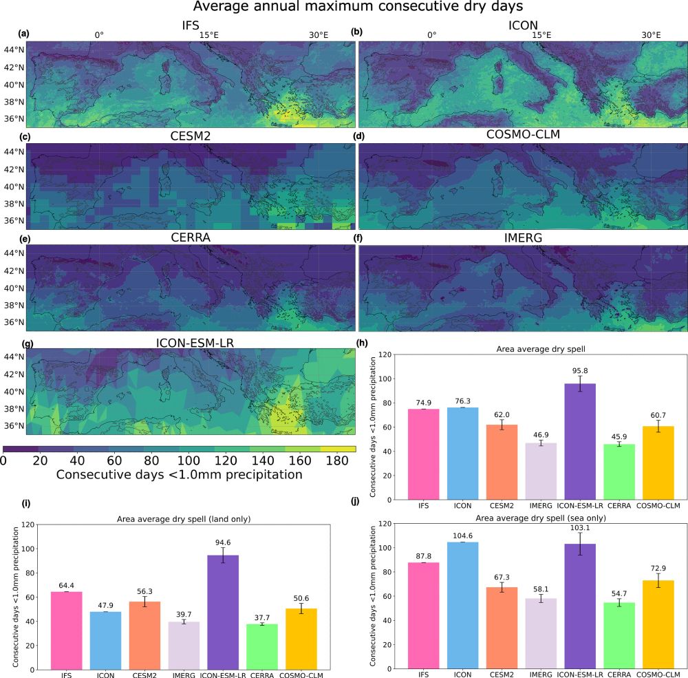
Greater differences are found in the average maximum annual dry spell. Here IFS and ICON produce very long dry spells compared to observations and a coarser global climate model (CESM2). The important exception here is the ICON model over land.
July 15, 2025 at 9:50 AM
Greater differences are found in the average maximum annual dry spell. Here IFS and ICON produce very long dry spells compared to observations and a coarser global climate model (CESM2). The important exception here is the ICON model over land.
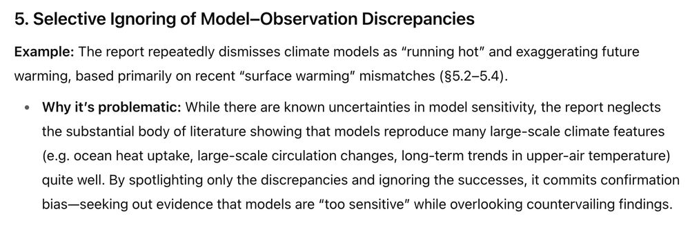
Focusing on the Mediterranean region, we test the added value of having very high resolution for depicting extreme precipitation (drought and flood). Starting with the percentage of days/hours with no rain, we find that the greatest improvements are over land. This is from the higher resolution
July 15, 2025 at 9:50 AM
Focusing on the Mediterranean region, we test the added value of having very high resolution for depicting extreme precipitation (drought and flood). Starting with the percentage of days/hours with no rain, we find that the greatest improvements are over land. This is from the higher resolution
This research focused on two experimental, fully-coupled, convection permitting Earth system models designed within the nextGEMS project. The IFS model has a hybrid convection parameterization scheme and ICON has no convection parameterization. These steps help push the models to higher resolution
July 15, 2025 at 9:50 AM
This research focused on two experimental, fully-coupled, convection permitting Earth system models designed within the nextGEMS project. The IFS model has a hybrid convection parameterization scheme and ICON has no convection parameterization. These steps help push the models to higher resolution
One motivation for developing kilometer-scale ESMs is to better understand how precipitation extremes will change in regions of complex topography. We need to provide local planners with greater detail on how precipitation extremes will challenge their infrastructure as the planet continues to warm
July 15, 2025 at 9:50 AM
One motivation for developing kilometer-scale ESMs is to better understand how precipitation extremes will change in regions of complex topography. We need to provide local planners with greater detail on how precipitation extremes will challenge their infrastructure as the planet continues to warm
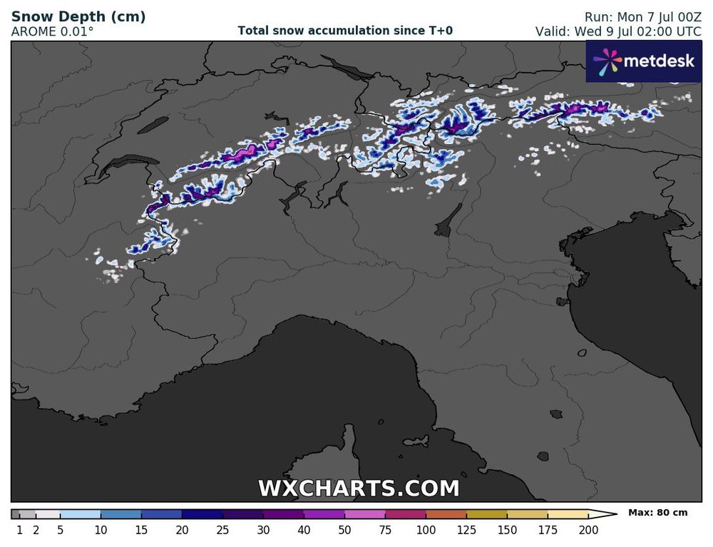
After a brutal start to the Alps melt season from an early season heatwave, we'll get a small reprieve with a series of cyclones drawing down cold, moist air from the north. In the highest elevations, there could be widespread accumulation of around 50 cm by Wednesday.
July 7, 2025 at 8:15 AM
After a brutal start to the Alps melt season from an early season heatwave, we'll get a small reprieve with a series of cyclones drawing down cold, moist air from the north. In the highest elevations, there could be widespread accumulation of around 50 cm by Wednesday.
Given that we are nearly in the Antarctic winter, absolute temperatures should remain below freezing so high amounts of snowfall across Thwaites Glacier will be the main impact. Still, I would be curious to see if any rainfall falls along the immediate coastline.

May 15, 2025 at 8:16 AM
Given that we are nearly in the Antarctic winter, absolute temperatures should remain below freezing so high amounts of snowfall across Thwaites Glacier will be the main impact. Still, I would be curious to see if any rainfall falls along the immediate coastline.
The 2m temperature anomalies from this moisture intrusion will be extreme. A large swath of West Antarctica will see temperatures in excess of 20 C for about 3-4 days. Note that the temperature variations across Antarctica are massive with -20 C anomalies on the other side of the system.


May 15, 2025 at 8:16 AM
The 2m temperature anomalies from this moisture intrusion will be extreme. A large swath of West Antarctica will see temperatures in excess of 20 C for about 3-4 days. Note that the temperature variations across Antarctica are massive with -20 C anomalies on the other side of the system.
Starting around May 17th, an atmospheric river will likely make landfall in the Thwaites and Pine Island region bringing large amounts of heat and moisture into West Antarctica. A deepening ridge will then push this moist airmass further into the continent eventually reaching the South Pole.


May 15, 2025 at 8:16 AM
Starting around May 17th, an atmospheric river will likely make landfall in the Thwaites and Pine Island region bringing large amounts of heat and moisture into West Antarctica. A deepening ridge will then push this moist airmass further into the continent eventually reaching the South Pole.
West Antarctica has been excessively warm the past month and an upcoming atmospheric river will likely lead to further extreme warmth in the coming days #antarctica #extremeweather 🧵

May 15, 2025 at 8:16 AM
West Antarctica has been excessively warm the past month and an upcoming atmospheric river will likely lead to further extreme warmth in the coming days #antarctica #extremeweather 🧵
For the Polar Meteorology crowd: we are organizing a session "Polar weather and climate extremes (M11)" at the BACO-25 assembly this July 20-25 in Busan, South Korea. The abstract deadline was extended to Feb. 25.
baco-25.org/new/sub2/sub...
Cheers,
The ICPM team
baco-25.org/new/sub2/sub...
Cheers,
The ICPM team

February 21, 2025 at 1:20 PM
For the Polar Meteorology crowd: we are organizing a session "Polar weather and climate extremes (M11)" at the BACO-25 assembly this July 20-25 in Busan, South Korea. The abstract deadline was extended to Feb. 25.
baco-25.org/new/sub2/sub...
Cheers,
The ICPM team
baco-25.org/new/sub2/sub...
Cheers,
The ICPM team
🧵 5/6 And then we visualize the processes in which ARs trigger surface melt and ice-shelf instability. The figure here shows a good example of an AR landfall on the Antarctic Peninsula.

February 11, 2025 at 11:00 AM
🧵 5/6 And then we visualize the processes in which ARs trigger surface melt and ice-shelf instability. The figure here shows a good example of an AR landfall on the Antarctic Peninsula.
🧵4/6 Placing Antarctic ARs in the context of extreme weather, we highlight all the documented impacts connected to AR landfalls on the Antarctic continent. This includes heat extremes, extreme snowfall, ice shelf collapse, rainfall, and surface melting.

February 11, 2025 at 11:00 AM
🧵4/6 Placing Antarctic ARs in the context of extreme weather, we highlight all the documented impacts connected to AR landfalls on the Antarctic continent. This includes heat extremes, extreme snowfall, ice shelf collapse, rainfall, and surface melting.
🧵 3/6 We go over the multiple methods of detecting and measuring Antarctic ARs and the resulting AR climatology that can be produced from these methods. This reenforces the idea that ARs in Antarctica are rare events, but dictate regional snowfall trends.

February 11, 2025 at 11:00 AM
🧵 3/6 We go over the multiple methods of detecting and measuring Antarctic ARs and the resulting AR climatology that can be produced from these methods. This reenforces the idea that ARs in Antarctica are rare events, but dictate regional snowfall trends.
🧵 2/4 A brief overview of what is discussed: We first synthesis the literature on Antarctic AR dynamics to create a model of AR life cycles from the sub-tropical moisture source to the interaction with coastal orography.

February 11, 2025 at 11:00 AM
🧵 2/4 A brief overview of what is discussed: We first synthesis the literature on Antarctic AR dynamics to create a model of AR life cycles from the sub-tropical moisture source to the interaction with coastal orography.
No wonder MAGA voters are operating on a different plane of reality when Fox News buries any mention of the Trump tariffs while some bullshit about a groundhog makes the front page.

February 2, 2025 at 1:50 PM
No wonder MAGA voters are operating on a different plane of reality when Fox News buries any mention of the Trump tariffs while some bullshit about a groundhog makes the front page.
For the atmospheric river community, I've updated my polar AR detection algorithm based on ERA5 data from 1980-2023. You can find a catalog of AR shapes on this public repository. Feel free to use for your Arctic and Antarctic studies. zenodo.org/records/1464...

January 14, 2025 at 4:01 PM
For the atmospheric river community, I've updated my polar AR detection algorithm based on ERA5 data from 1980-2023. You can find a catalog of AR shapes on this public repository. Feel free to use for your Arctic and Antarctic studies. zenodo.org/records/1464...