


Reposted
Geolocation| Israeli forces blow up approx. 10 buildings amid vast destruction in the Al-Geneina neighborhood of Rafah, South #Gaza
31.276241, 34.268828
31.275852, 34.268056
31.277062, 34.267637
Posted on 30 Sep.
Video: t.me/yinonews/43473
31.276241, 34.268828
31.275852, 34.268056
31.277062, 34.267637
Posted on 30 Sep.
Video: t.me/yinonews/43473


September 30, 2025 at 9:19 PM
Geolocation| Israeli forces blow up approx. 10 buildings amid vast destruction in the Al-Geneina neighborhood of Rafah, South #Gaza
31.276241, 34.268828
31.275852, 34.268056
31.277062, 34.267637
Posted on 30 Sep.
Video: t.me/yinonews/43473
31.276241, 34.268828
31.275852, 34.268056
31.277062, 34.267637
Posted on 30 Sep.
Video: t.me/yinonews/43473
Reposted
Geolocation| Israeli forces driving through northern Gaza City, near the Egyptian Towers, Northern #Gaza
A CAT excavator is also visible on top of a destroyed building.
POV: 31.546722, 34.463439
Vehicles: 31.547607, 34.463946
Video: t.me/TrackingIsra...
A CAT excavator is also visible on top of a destroyed building.
POV: 31.546722, 34.463439
Vehicles: 31.547607, 34.463946
Video: t.me/TrackingIsra...

October 4, 2025 at 7:51 PM
Geolocation| Israeli forces driving through northern Gaza City, near the Egyptian Towers, Northern #Gaza
A CAT excavator is also visible on top of a destroyed building.
POV: 31.546722, 34.463439
Vehicles: 31.547607, 34.463946
Video: t.me/TrackingIsra...
A CAT excavator is also visible on top of a destroyed building.
POV: 31.546722, 34.463439
Vehicles: 31.547607, 34.463946
Video: t.me/TrackingIsra...
Reposted

These towers surround Gaza's Roman Cemetery — an ancient intact burial site with 125 tombs that was discovered in 2022. @premiereurgenceint.bsky.social worked on the site before the war: www.theartnewspaper.com/2023/07/26/r...
Can see the site in a video from 2023: www.youtube.com/watch?v=VStQ...
Can see the site in a video from 2023: www.youtube.com/watch?v=VStQ...

September 29, 2025 at 2:02 PM
These towers surround Gaza's Roman Cemetery — an ancient intact burial site with 125 tombs that was discovered in 2022. @premiereurgenceint.bsky.social worked on the site before the war: www.theartnewspaper.com/2023/07/26/r...
Can see the site in a video from 2023: www.youtube.com/watch?v=VStQ...
Can see the site in a video from 2023: www.youtube.com/watch?v=VStQ...
Reposted
Geolocation| Aftermath of an Israeli airstrike, reportedly on the Abdel Aal family house near Al-Yaffa Street in the Al-Tuffah neighborhood, Gaza City, Northern #Gaza
18 people were reportedly killed.
31.511656, 34.470293
🗓️4 Oct. 2025
Photos: [GRAPHIC] www.facebook.com/rakan2021r/p...
18 people were reportedly killed.
31.511656, 34.470293
🗓️4 Oct. 2025
Photos: [GRAPHIC] www.facebook.com/rakan2021r/p...

October 4, 2025 at 10:27 PM
Geolocation| Aftermath of an Israeli airstrike, reportedly on the Abdel Aal family house near Al-Yaffa Street in the Al-Tuffah neighborhood, Gaza City, Northern #Gaza
18 people were reportedly killed.
31.511656, 34.470293
🗓️4 Oct. 2025
Photos: [GRAPHIC] www.facebook.com/rakan2021r/p...
18 people were reportedly killed.
31.511656, 34.470293
🗓️4 Oct. 2025
Photos: [GRAPHIC] www.facebook.com/rakan2021r/p...
Reposted

How Reform ‘misinformation’ campaign sank town’s refugee sanctuary plan www.theguardian.com/uk-news/2025...

How Reform ‘misinformation’ campaign sank town’s refugee sanctuary plan
Party accused of stoking divisions in Weston-super-Mare over scheme to improve support for asylum seekers
www.theguardian.com
October 5, 2025 at 8:04 AM
How Reform ‘misinformation’ campaign sank town’s refugee sanctuary plan www.theguardian.com/uk-news/2025...
Reposted

‘We are trying as much as possible with the very limited resources available to keep her alive until she can be evacuated. Without an urgent transfer, we sadly expect that she could die at any moment.’
#JanaAyyad #Gaza
@willchristou.bsky.social
www.theguardian.com/world/2025/s...
#JanaAyyad #Gaza
@willchristou.bsky.social
www.theguardian.com/world/2025/s...

‘She could die any moment’: family of girl, eight, plead for urgent evacuation from Gaza
Officials say they applied for Jana Ayyad to be transferred to Jordan two weeks ago but have not received Israeli approval
www.theguardian.com
September 5, 2025 at 6:08 PM
‘We are trying as much as possible with the very limited resources available to keep her alive until she can be evacuated. Without an urgent transfer, we sadly expect that she could die at any moment.’
#JanaAyyad #Gaza
@willchristou.bsky.social
www.theguardian.com/world/2025/s...
#JanaAyyad #Gaza
@willchristou.bsky.social
www.theguardian.com/world/2025/s...
Reposted
Geolocation| An airdropped pellet of aid falling down with a malfunctioning parachute hits a building in southern Deir Al-Balah, Central #Gaza
31.396275, 34.324394
Video: www.instagram.com/p/DNr9YFC0Md-/
31.396275, 34.324394
Video: www.instagram.com/p/DNr9YFC0Md-/


August 24, 2025 at 4:51 PM
Geolocation| An airdropped pellet of aid falling down with a malfunctioning parachute hits a building in southern Deir Al-Balah, Central #Gaza
31.396275, 34.324394
Video: www.instagram.com/p/DNr9YFC0Md-/
31.396275, 34.324394
Video: www.instagram.com/p/DNr9YFC0Md-/
Reposted
Just for awareness of the area around Nasser Hospital and central/northern Khan Yunis, there's some partial @planet.com SkySat from yesterday showing an IDF outpost about 2.5km NE of the hospital and the heavy destruction that's taken place since June.
Most recent SkySat over Nasser was August 4.
Most recent SkySat over Nasser was August 4.

August 25, 2025 at 6:27 PM
Just for awareness of the area around Nasser Hospital and central/northern Khan Yunis, there's some partial @planet.com SkySat from yesterday showing an IDF outpost about 2.5km NE of the hospital and the heavy destruction that's taken place since June.
Most recent SkySat over Nasser was August 4.
Most recent SkySat over Nasser was August 4.
Reposted
Geolocation| A photo taken by an Israeli soldier of eastern Deir Al-Balah with the (partly destroyed) Al-Qastel Towers visible in the background, Central #Gaza
The photo could be taken from an Israeli military position at the barrier: 31.387101, 34.380692
t.me/TrackingIsra...
The photo could be taken from an Israeli military position at the barrier: 31.387101, 34.380692
t.me/TrackingIsra...


August 23, 2025 at 9:57 PM
Geolocation| A photo taken by an Israeli soldier of eastern Deir Al-Balah with the (partly destroyed) Al-Qastel Towers visible in the background, Central #Gaza
The photo could be taken from an Israeli military position at the barrier: 31.387101, 34.380692
t.me/TrackingIsra...
The photo could be taken from an Israeli military position at the barrier: 31.387101, 34.380692
t.me/TrackingIsra...

Reposted

Very concerning that mass shooters are starting to adopt a style of "shitposting" that combines the aesthetics of Tarrant-style Nazism with a self-aware, terminally-online-zoomer nihilism. Nothing in these manifestos (or written on AR-15s) should be taken literally.
August 27, 2025 at 6:58 PM
Very concerning that mass shooters are starting to adopt a style of "shitposting" that combines the aesthetics of Tarrant-style Nazism with a self-aware, terminally-online-zoomer nihilism. Nothing in these manifestos (or written on AR-15s) should be taken literally.
Reposted

On one of the most unbelievable satellite images I've ever seen, showing hundreds of Palestinians surrounding aid trucks north of Rafah.
www.nytimes.com/2025/07/29/w...
www.nytimes.com/2025/07/29/w...
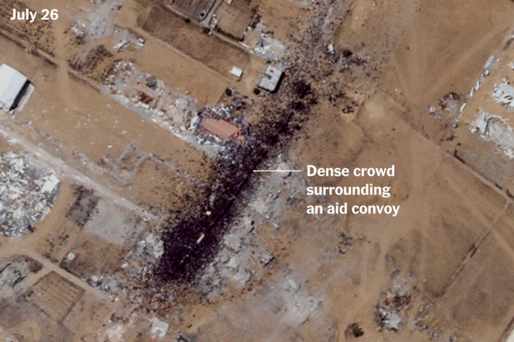
A World of Misery, From 200 Miles Up
www.nytimes.com
July 30, 2025 at 1:12 AM
On one of the most unbelievable satellite images I've ever seen, showing hundreds of Palestinians surrounding aid trucks north of Rafah.
www.nytimes.com/2025/07/29/w...
www.nytimes.com/2025/07/29/w...
Reposted
Israel justified its strike on the Nasser Hospital, which killed six journalists and more than a dozen others, by claiming a "Hamas" camera was set up there.
The location they attacked is where Reuters and the AP livestream.
From me and others (see byline/contribs)
www.nytimes.com/2025/08/26/w...
The location they attacked is where Reuters and the AP livestream.
From me and others (see byline/contribs)
www.nytimes.com/2025/08/26/w...

Israel Says It Attacked Gaza Hospital to Destroy Camera Placed by Hamas
www.nytimes.com
August 26, 2025 at 9:31 PM
Israel justified its strike on the Nasser Hospital, which killed six journalists and more than a dozen others, by claiming a "Hamas" camera was set up there.
The location they attacked is where Reuters and the AP livestream.
From me and others (see byline/contribs)
www.nytimes.com/2025/08/26/w...
The location they attacked is where Reuters and the AP livestream.
From me and others (see byline/contribs)
www.nytimes.com/2025/08/26/w...
Reposted
It's important that @itvnews.bsky.social was able to film the devastation in Gaza, but I'd note the buildings identified as the Turkish Hospital in their video at the 1:19 timestamp is incorrect.
The hospital is nearby at 31.4778, 34.4162. The buildings they highlight are at 31.4769, 34.4081.
The hospital is nearby at 31.4778, 34.4162. The buildings they highlight are at 31.4769, 34.4081.

August 8, 2025 at 1:47 PM
It's important that @itvnews.bsky.social was able to film the devastation in Gaza, but I'd note the buildings identified as the Turkish Hospital in their video at the 1:19 timestamp is incorrect.
The hospital is nearby at 31.4778, 34.4162. The buildings they highlight are at 31.4769, 34.4081.
The hospital is nearby at 31.4778, 34.4162. The buildings they highlight are at 31.4769, 34.4081.
Reposted

NEW: Israeli forces’ deadly attacks on schools sheltering Palestinian civilians highlight the absence of safe places for displaced people, the vast majority of Gaza’s population.
Read more: www.hrw.org/news/2025/08...
Read more: www.hrw.org/news/2025/08...

August 7, 2025 at 1:28 PM
NEW: Israeli forces’ deadly attacks on schools sheltering Palestinian civilians highlight the absence of safe places for displaced people, the vast majority of Gaza’s population.
Read more: www.hrw.org/news/2025/08...
Read more: www.hrw.org/news/2025/08...
Reposted
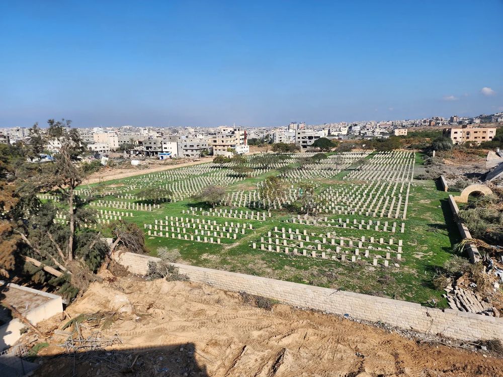
While July 31 @planet.com imagery shows some more minor damage — it at least shows the dirt berm area was not expanded. That space included hundreds of now-bulldozed gravestones.
A June image from Middle East Eye shows the same corner that's now been destroyed: www.middleeasteye.net/sites/defaul...
A June image from Middle East Eye shows the same corner that's now been destroyed: www.middleeasteye.net/sites/defaul...
August 1, 2025 at 8:28 PM
While July 31 @planet.com imagery shows some more minor damage — it at least shows the dirt berm area was not expanded. That space included hundreds of now-bulldozed gravestones.
A June image from Middle East Eye shows the same corner that's now been destroyed: www.middleeasteye.net/sites/defaul...
A June image from Middle East Eye shows the same corner that's now been destroyed: www.middleeasteye.net/sites/defaul...
Reposted
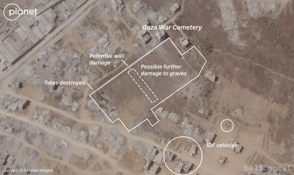
Sadly new SkySat imagery from @planet.com shows that even more graves at the Commonwealth Gaza War Cemetery ran by @cwgc.bsky.social have been destroyed by the IDF. Parts of Sections A, B, XXV, XVII, XVIII and XXVI appear to have been completely bulldozed with the creation of dirt berms on July 27.


August 1, 2025 at 8:16 PM
Sadly new SkySat imagery from @planet.com shows that even more graves at the Commonwealth Gaza War Cemetery ran by @cwgc.bsky.social have been destroyed by the IDF. Parts of Sections A, B, XXV, XVII, XVIII and XXVI appear to have been completely bulldozed with the creation of dirt berms on July 27.
Reposted
Related to the reported assault on Gaza's Deir al-Balah, July 21 PlanetScope imagery from @planet.com shows a large warehouse at 31.4031, 34.3349 on fire and what appear to be clearings and airstrikes by the IDF.
This area has been full of internally displaced Palestinians since early 2024.
This area has been full of internally displaced Palestinians since early 2024.


July 21, 2025 at 8:17 PM
Related to the reported assault on Gaza's Deir al-Balah, July 21 PlanetScope imagery from @planet.com shows a large warehouse at 31.4031, 34.3349 on fire and what appear to be clearings and airstrikes by the IDF.
This area has been full of internally displaced Palestinians since early 2024.
This area has been full of internally displaced Palestinians since early 2024.
Reposted
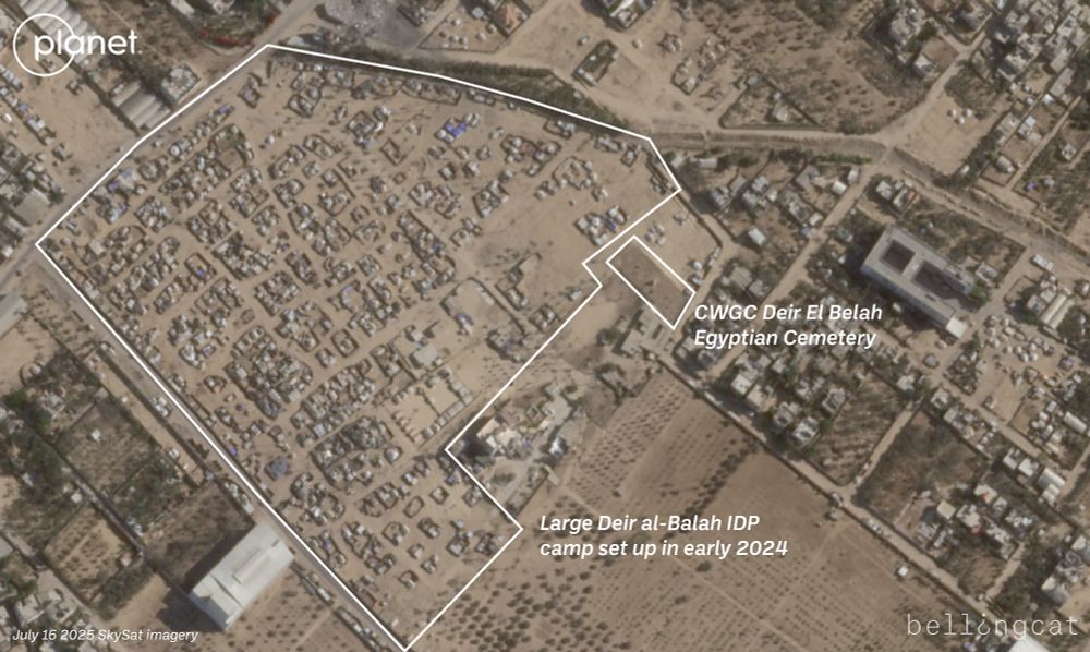
We now have @planet.com SkySat imagery over this area from July 22. A zoomed-in look at the large area of IDP camps shows that they've been removed or destroyed by the IDF.
Also appears the Egyptian Cemetery, a @cwgc.bsky.social WW1 site, has been destroyed or damaged.
www.cwgc.org/visit-us/fin...
Also appears the Egyptian Cemetery, a @cwgc.bsky.social WW1 site, has been destroyed or damaged.
www.cwgc.org/visit-us/fin...

July 23, 2025 at 7:56 PM
We now have @planet.com SkySat imagery over this area from July 22. A zoomed-in look at the large area of IDP camps shows that they've been removed or destroyed by the IDF.
Also appears the Egyptian Cemetery, a @cwgc.bsky.social WW1 site, has been destroyed or damaged.
www.cwgc.org/visit-us/fin...
Also appears the Egyptian Cemetery, a @cwgc.bsky.social WW1 site, has been destroyed or damaged.
www.cwgc.org/visit-us/fin...
Reposted

The suffering of Palestinians in #Gaza is worsened by the deplorable contamination they face everyday from garbage and polluted water due to Israel's ongoing genocide. Our @paxforpeace.nl data was used to improve detection of solid waste piles. A bleak overview:
www.bloomberg.com/graphics/202...
www.bloomberg.com/graphics/202...

The War in Gaza Leaves Toxic Legacy of Garbage, Disease and Pollution
The bombardment of Gaza has left a toxic legacy of contaminated soil, blackened water and disease-spreading garbage that will last generations.
www.bloomberg.com
July 24, 2025 at 8:55 AM
The suffering of Palestinians in #Gaza is worsened by the deplorable contamination they face everyday from garbage and polluted water due to Israel's ongoing genocide. Our @paxforpeace.nl data was used to improve detection of solid waste piles. A bleak overview:
www.bloomberg.com/graphics/202...
www.bloomberg.com/graphics/202...
Reposted

While starving Gaza and its 80% refugee population, Israel is expanding its war on Palestinian refugees—and on their very ‘refugee-ness’—in the West Bank.
July 24, 2025 at 6:54 PM
While starving Gaza and its 80% refugee population, Israel is expanding its war on Palestinian refugees—and on their very ‘refugee-ness’—in the West Bank.
Reposted
Example of the below Haaretz piece in satellite imagery: Recent SkySat from @planet.com shows that almost 100% of Tal as-Sultan, a large part of Rafah in the northern part of the governorate, has been destroyed by the IDF. The neighboring Saudi Housing Project north of that is now being demolished.


July 15, 2025 at 7:25 PM
Example of the below Haaretz piece in satellite imagery: Recent SkySat from @planet.com shows that almost 100% of Tal as-Sultan, a large part of Rafah in the northern part of the governorate, has been destroyed by the IDF. The neighboring Saudi Housing Project north of that is now being demolished.
Reposted
Unfortunately there has been further damage at the Jabaliya Byzantine church archeological site after it was damaged earlier this year.
The reception buildings have been destroyed. The protective structure that surrounded the 1,500 year-old mosaics also appears to have been partially destroyed.
The reception buildings have been destroyed. The protective structure that surrounded the 1,500 year-old mosaics also appears to have been partially destroyed.


July 17, 2025 at 3:07 PM
Unfortunately there has been further damage at the Jabaliya Byzantine church archeological site after it was damaged earlier this year.
The reception buildings have been destroyed. The protective structure that surrounded the 1,500 year-old mosaics also appears to have been partially destroyed.
The reception buildings have been destroyed. The protective structure that surrounded the 1,500 year-old mosaics also appears to have been partially destroyed.
Reposted
Recent SkySat imagery from @planet.com shows that in less than a month (June 20 -> July 17), the IDF have carved a large corridor of destruction between the southern Gaza cities of Khan Yunis and Bani Suheila. Hundreds of homes and buildings destroyed.


July 18, 2025 at 6:15 PM
Recent SkySat imagery from @planet.com shows that in less than a month (June 20 -> July 17), the IDF have carved a large corridor of destruction between the southern Gaza cities of Khan Yunis and Bani Suheila. Hundreds of homes and buildings destroyed.
Reposted
Geolocation| Israeli forces blow up the UNRWA Dammam Joint Preparatory School amid vast destruction in the Saudi neighborhood of Rafah, South #Gaza
31.316737, 34.240881
Video: t.me/baznews9/23450
31.316737, 34.240881
Video: t.me/baznews9/23450


July 18, 2025 at 7:05 PM
Geolocation| Israeli forces blow up the UNRWA Dammam Joint Preparatory School amid vast destruction in the Saudi neighborhood of Rafah, South #Gaza
31.316737, 34.240881
Video: t.me/baznews9/23450
31.316737, 34.240881
Video: t.me/baznews9/23450