


HeiGIT
@heigit.org
Open-source geoinformation, methods and software for the benefit of the environment and society.
---
This is the official account of HeiGIT (Heidelberg Institute for Geoinformation Technology) at Heidelberg University.
Check us out at https://heigit.org/
---
This is the official account of HeiGIT (Heidelberg Institute for Geoinformation Technology) at Heidelberg University.
Check us out at https://heigit.org/
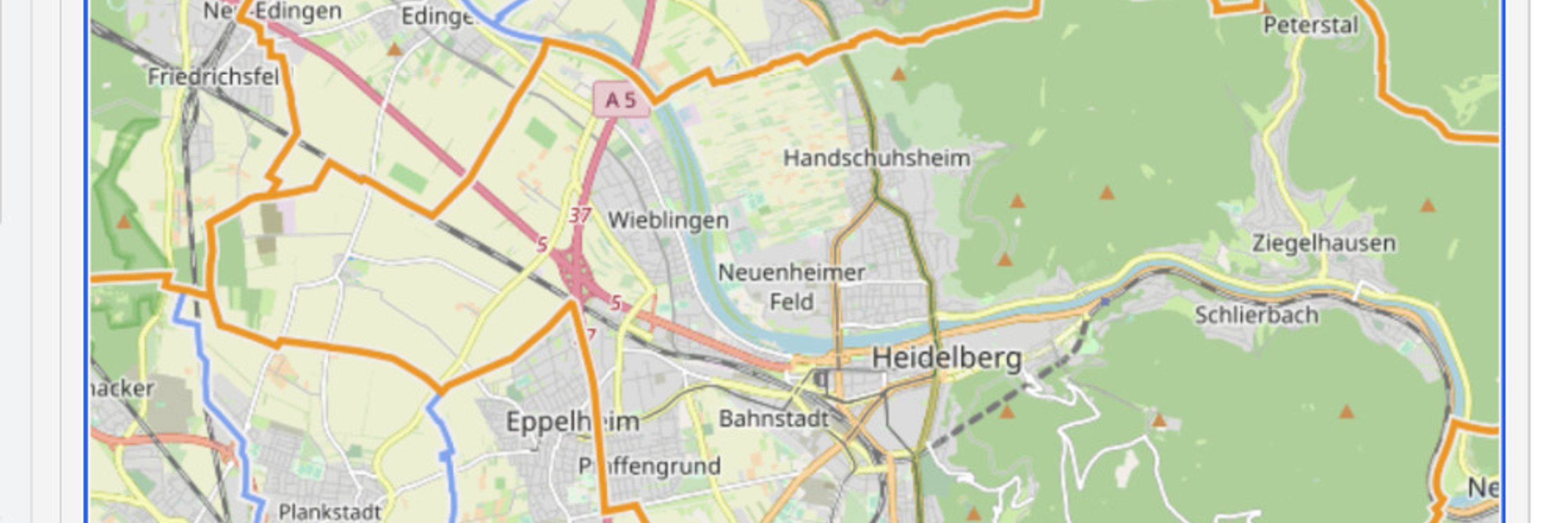
🌍 Join our Mapathon for Geography Awareness Week!
We’re teaming up with the University of Würzburg, GeoDACH and AFNEG for an evening of open mapping in support of #MSF work in Indonesia.
🗓️ 18:30–21:30
📍 Im Neuenheimer Feld 205, 69120 HD (5th floor, IWR)
👉 heigit.org/events/geogr...
We’re teaming up with the University of Würzburg, GeoDACH and AFNEG for an evening of open mapping in support of #MSF work in Indonesia.
🗓️ 18:30–21:30
📍 Im Neuenheimer Feld 205, 69120 HD (5th floor, IWR)
👉 heigit.org/events/geogr...

November 13, 2025 at 8:54 AM
🌍 Join our Mapathon for Geography Awareness Week!
We’re teaming up with the University of Würzburg, GeoDACH and AFNEG for an evening of open mapping in support of #MSF work in Indonesia.
🗓️ 18:30–21:30
📍 Im Neuenheimer Feld 205, 69120 HD (5th floor, IWR)
👉 heigit.org/events/geogr...
We’re teaming up with the University of Würzburg, GeoDACH and AFNEG for an evening of open mapping in support of #MSF work in Indonesia.
🗓️ 18:30–21:30
📍 Im Neuenheimer Feld 205, 69120 HD (5th floor, IWR)
👉 heigit.org/events/geogr...
🌍 Excited to share that our AI Logistic Awareness System (AILAS) is featured in WIPO’s Green Technology Book 2025!
AILAS uses #AI, #geospatial analytics & #opendata for weather-adaptive routing, improving disaster logistics & #resilience.
AILAS: heigit.org/ailas/
Book: tinyurl.com/ymuyvx8f
AILAS uses #AI, #geospatial analytics & #opendata for weather-adaptive routing, improving disaster logistics & #resilience.
AILAS: heigit.org/ailas/
Book: tinyurl.com/ymuyvx8f

November 12, 2025 at 8:32 AM
🌍 Excited to share that our AI Logistic Awareness System (AILAS) is featured in WIPO’s Green Technology Book 2025!
AILAS uses #AI, #geospatial analytics & #opendata for weather-adaptive routing, improving disaster logistics & #resilience.
AILAS: heigit.org/ailas/
Book: tinyurl.com/ymuyvx8f
AILAS uses #AI, #geospatial analytics & #opendata for weather-adaptive routing, improving disaster logistics & #resilience.
AILAS: heigit.org/ailas/
Book: tinyurl.com/ymuyvx8f
🌾New research: Why are sugarcane farms abandoned in Rio de Janeiro State?
New research shows local factors matter:
Water stress
Steep terrain
Distance from sugar mills
Climate + accessibility are key factors for #sustainable rural planning and #LandUse.
👉 heigit.org/new-paper-pr...
New research shows local factors matter:
Water stress
Steep terrain
Distance from sugar mills
Climate + accessibility are key factors for #sustainable rural planning and #LandUse.
👉 heigit.org/new-paper-pr...

November 10, 2025 at 8:45 AM
🌾New research: Why are sugarcane farms abandoned in Rio de Janeiro State?
New research shows local factors matter:
Water stress
Steep terrain
Distance from sugar mills
Climate + accessibility are key factors for #sustainable rural planning and #LandUse.
👉 heigit.org/new-paper-pr...
New research shows local factors matter:
Water stress
Steep terrain
Distance from sugar mills
Climate + accessibility are key factors for #sustainable rural planning and #LandUse.
👉 heigit.org/new-paper-pr...
#𝟯𝟬𝗗𝗮𝘆𝗠𝗮𝗽𝗖𝗵𝗮𝗹𝗹𝗲𝗻𝗴𝗲 - 𝗗𝗮𝘆 𝟳 𝗔𝗰𝗰𝗲𝘀𝘀𝗶𝗯𝗶𝗹𝗶𝘁𝘆
𝘗𝘳𝘦-𝘧𝘭𝘰𝘰𝘥𝘪𝘯𝘨 𝘢𝘤𝘤𝘦𝘴𝘴𝘪𝘣𝘪𝘭𝘪𝘵𝘺 𝘢𝘤𝘳𝘰𝘴𝘴 𝘗𝘰𝘳𝘵𝘰 𝘈𝘭𝘦𝘨𝘳𝘦, 𝘉𝘳𝘢𝘻𝘪𝘭 🇧🇷
Today’s map highlights road accessibility before the 2024 floods in #PortoAlegre, focusing on the BR-290 Freeway.
💡Mapping accessibility helps reveal vulnerabilities in transport networks.
𝘗𝘳𝘦-𝘧𝘭𝘰𝘰𝘥𝘪𝘯𝘨 𝘢𝘤𝘤𝘦𝘴𝘴𝘪𝘣𝘪𝘭𝘪𝘵𝘺 𝘢𝘤𝘳𝘰𝘴𝘴 𝘗𝘰𝘳𝘵𝘰 𝘈𝘭𝘦𝘨𝘳𝘦, 𝘉𝘳𝘢𝘻𝘪𝘭 🇧🇷
Today’s map highlights road accessibility before the 2024 floods in #PortoAlegre, focusing on the BR-290 Freeway.
💡Mapping accessibility helps reveal vulnerabilities in transport networks.

November 7, 2025 at 9:00 AM
#𝟯𝟬𝗗𝗮𝘆𝗠𝗮𝗽𝗖𝗵𝗮𝗹𝗹𝗲𝗻𝗴𝗲 - 𝗗𝗮𝘆 𝟳 𝗔𝗰𝗰𝗲𝘀𝘀𝗶𝗯𝗶𝗹𝗶𝘁𝘆
𝘗𝘳𝘦-𝘧𝘭𝘰𝘰𝘥𝘪𝘯𝘨 𝘢𝘤𝘤𝘦𝘴𝘴𝘪𝘣𝘪𝘭𝘪𝘵𝘺 𝘢𝘤𝘳𝘰𝘴𝘴 𝘗𝘰𝘳𝘵𝘰 𝘈𝘭𝘦𝘨𝘳𝘦, 𝘉𝘳𝘢𝘻𝘪𝘭 🇧🇷
Today’s map highlights road accessibility before the 2024 floods in #PortoAlegre, focusing on the BR-290 Freeway.
💡Mapping accessibility helps reveal vulnerabilities in transport networks.
𝘗𝘳𝘦-𝘧𝘭𝘰𝘰𝘥𝘪𝘯𝘨 𝘢𝘤𝘤𝘦𝘴𝘴𝘪𝘣𝘪𝘭𝘪𝘵𝘺 𝘢𝘤𝘳𝘰𝘴𝘴 𝘗𝘰𝘳𝘵𝘰 𝘈𝘭𝘦𝘨𝘳𝘦, 𝘉𝘳𝘢𝘻𝘪𝘭 🇧🇷
Today’s map highlights road accessibility before the 2024 floods in #PortoAlegre, focusing on the BR-290 Freeway.
💡Mapping accessibility helps reveal vulnerabilities in transport networks.
#𝟯𝟬𝗗𝗮𝘆𝗠𝗮𝗽𝗖𝗵𝗮𝗹𝗹𝗲𝗻𝗴𝗲 - 𝗗𝗮𝘆 𝟲: 𝗗𝗶𝗺𝗲𝗻𝘀𝗶𝗼𝗻𝘀
𝘈𝘶𝘵𝘰 𝘨𝘦𝘯𝘦𝘳𝘢𝘵𝘦𝘥 3𝘋 𝘣𝘶𝘪𝘭𝘥𝘪𝘯𝘨 𝘮𝘰𝘥𝘦𝘭𝘴 𝘪𝘯 𝘛𝘳𝘰𝘯𝘥𝘩𝘦𝘪𝘮, 𝘕𝘰𝘳𝘸𝘢𝘺 𝘷𝘪𝘴𝘶𝘢𝘭𝘪𝘻𝘦𝘥 𝘰𝘯 𝘵𝘩𝘦 𝘊𝘦𝘭𝘴𝘪𝘶𝘴 𝘱𝘭𝘢𝘵𝘧𝘰𝘳𝘮
Today’s map goes beyond 2D, visualizing Trondheim, Norway, in three dimensions.
The 3D building models were automatically generated in LoD2 (Level of Detail 2) from ALS.
𝘈𝘶𝘵𝘰 𝘨𝘦𝘯𝘦𝘳𝘢𝘵𝘦𝘥 3𝘋 𝘣𝘶𝘪𝘭𝘥𝘪𝘯𝘨 𝘮𝘰𝘥𝘦𝘭𝘴 𝘪𝘯 𝘛𝘳𝘰𝘯𝘥𝘩𝘦𝘪𝘮, 𝘕𝘰𝘳𝘸𝘢𝘺 𝘷𝘪𝘴𝘶𝘢𝘭𝘪𝘻𝘦𝘥 𝘰𝘯 𝘵𝘩𝘦 𝘊𝘦𝘭𝘴𝘪𝘶𝘴 𝘱𝘭𝘢𝘵𝘧𝘰𝘳𝘮
Today’s map goes beyond 2D, visualizing Trondheim, Norway, in three dimensions.
The 3D building models were automatically generated in LoD2 (Level of Detail 2) from ALS.

November 6, 2025 at 9:26 AM
#𝟯𝟬𝗗𝗮𝘆𝗠𝗮𝗽𝗖𝗵𝗮𝗹𝗹𝗲𝗻𝗴𝗲 - 𝗗𝗮𝘆 𝟲: 𝗗𝗶𝗺𝗲𝗻𝘀𝗶𝗼𝗻𝘀
𝘈𝘶𝘵𝘰 𝘨𝘦𝘯𝘦𝘳𝘢𝘵𝘦𝘥 3𝘋 𝘣𝘶𝘪𝘭𝘥𝘪𝘯𝘨 𝘮𝘰𝘥𝘦𝘭𝘴 𝘪𝘯 𝘛𝘳𝘰𝘯𝘥𝘩𝘦𝘪𝘮, 𝘕𝘰𝘳𝘸𝘢𝘺 𝘷𝘪𝘴𝘶𝘢𝘭𝘪𝘻𝘦𝘥 𝘰𝘯 𝘵𝘩𝘦 𝘊𝘦𝘭𝘴𝘪𝘶𝘴 𝘱𝘭𝘢𝘵𝘧𝘰𝘳𝘮
Today’s map goes beyond 2D, visualizing Trondheim, Norway, in three dimensions.
The 3D building models were automatically generated in LoD2 (Level of Detail 2) from ALS.
𝘈𝘶𝘵𝘰 𝘨𝘦𝘯𝘦𝘳𝘢𝘵𝘦𝘥 3𝘋 𝘣𝘶𝘪𝘭𝘥𝘪𝘯𝘨 𝘮𝘰𝘥𝘦𝘭𝘴 𝘪𝘯 𝘛𝘳𝘰𝘯𝘥𝘩𝘦𝘪𝘮, 𝘕𝘰𝘳𝘸𝘢𝘺 𝘷𝘪𝘴𝘶𝘢𝘭𝘪𝘻𝘦𝘥 𝘰𝘯 𝘵𝘩𝘦 𝘊𝘦𝘭𝘴𝘪𝘶𝘴 𝘱𝘭𝘢𝘵𝘧𝘰𝘳𝘮
Today’s map goes beyond 2D, visualizing Trondheim, Norway, in three dimensions.
The 3D building models were automatically generated in LoD2 (Level of Detail 2) from ALS.
HeiGIT welcomes Stefan Gumbrich as new Managing Director!
Stefan, our former Innovation Manager with a PhD in Informatics and 20+ years at IBM, succeeds Gesa Schönberger. Thank you, Gesa, for your exceptional leadership. Onward with open geoinformation for social good!
heigit.org/heigit-welco...
Stefan, our former Innovation Manager with a PhD in Informatics and 20+ years at IBM, succeeds Gesa Schönberger. Thank you, Gesa, for your exceptional leadership. Onward with open geoinformation for social good!
heigit.org/heigit-welco...

November 5, 2025 at 2:15 PM
HeiGIT welcomes Stefan Gumbrich as new Managing Director!
Stefan, our former Innovation Manager with a PhD in Informatics and 20+ years at IBM, succeeds Gesa Schönberger. Thank you, Gesa, for your exceptional leadership. Onward with open geoinformation for social good!
heigit.org/heigit-welco...
Stefan, our former Innovation Manager with a PhD in Informatics and 20+ years at IBM, succeeds Gesa Schönberger. Thank you, Gesa, for your exceptional leadership. Onward with open geoinformation for social good!
heigit.org/heigit-welco...
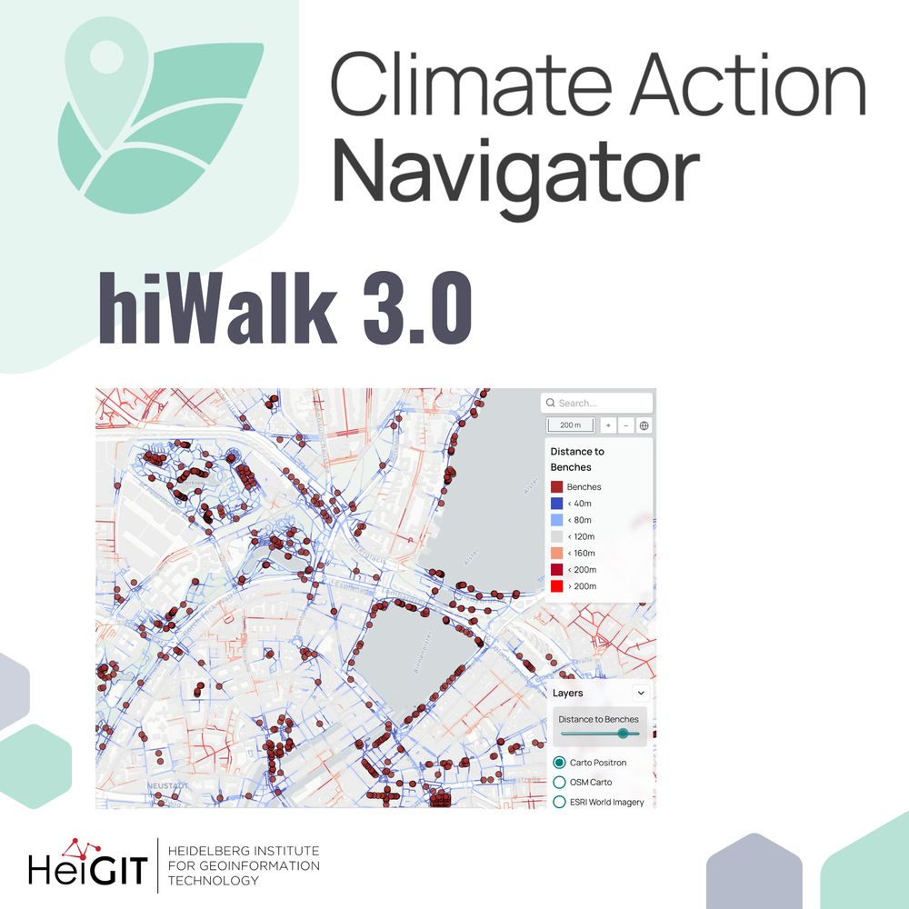
We are excited to introduce hiWalk 3.0🚶♀️, which expands our walkability analysis with two indicators: distance to benches and distance to drinking fountains.⛲. Explore how your city performs and help improve OpenStreetMap by adding missing benches or fountains!
🔍 heigit.org?p=40878
🔍 heigit.org?p=40878
November 4, 2025 at 9:15 AM
We are excited to introduce hiWalk 3.0🚶♀️, which expands our walkability analysis with two indicators: distance to benches and distance to drinking fountains.⛲. Explore how your city performs and help improve OpenStreetMap by adding missing benches or fountains!
🔍 heigit.org?p=40878
🔍 heigit.org?p=40878
𝗛𝗲𝗶𝗚𝗜𝗧 𝗮𝘁 𝗦𝘁𝗮𝘁𝗲 𝗼𝗳 𝘁𝗵𝗲 𝗠𝗮𝗽 𝗘𝘂𝗿𝗼𝗽𝗲🌍📍
We will join SotM Europe with several sessions on #OpenStreetMap, #geoAI, and humanitarian mapping. We look forward to discussing how Open Data, community collaboration and AI shape the future of mapping.
💡Our contributions: heigit.org/events/heigi...
We will join SotM Europe with several sessions on #OpenStreetMap, #geoAI, and humanitarian mapping. We look forward to discussing how Open Data, community collaboration and AI shape the future of mapping.
💡Our contributions: heigit.org/events/heigi...

November 3, 2025 at 8:12 AM
𝗛𝗲𝗶𝗚𝗜𝗧 𝗮𝘁 𝗦𝘁𝗮𝘁𝗲 𝗼𝗳 𝘁𝗵𝗲 𝗠𝗮𝗽 𝗘𝘂𝗿𝗼𝗽𝗲🌍📍
We will join SotM Europe with several sessions on #OpenStreetMap, #geoAI, and humanitarian mapping. We look forward to discussing how Open Data, community collaboration and AI shape the future of mapping.
💡Our contributions: heigit.org/events/heigi...
We will join SotM Europe with several sessions on #OpenStreetMap, #geoAI, and humanitarian mapping. We look forward to discussing how Open Data, community collaboration and AI shape the future of mapping.
💡Our contributions: heigit.org/events/heigi...
#𝟯𝟬𝗗𝗮𝘆𝗠𝗮𝗽𝗖𝗵𝗮𝗹𝗹𝗲𝗻𝗴𝗲 - 𝗗𝗮𝘆 𝟮: 𝗟𝗶𝗻𝗲𝘀
𝘔𝘢𝘱𝘱𝘪𝘯𝘨 𝘳𝘰𝘢𝘥 𝘤𝘰𝘯𝘥𝘪𝘵𝘪𝘰𝘯𝘴 𝘪𝘯 𝘈𝘤𝘤𝘳𝘢, 𝘎𝘩𝘢𝘯𝘢
By combining Planet satellite data with Mapillary imagery, we reveal road infrastructure gaps.
🔍 Dataset: data.humdata.org/organization...
📆 Stay tuned for the release of a new road surface dataset!
𝘔𝘢𝘱𝘱𝘪𝘯𝘨 𝘳𝘰𝘢𝘥 𝘤𝘰𝘯𝘥𝘪𝘵𝘪𝘰𝘯𝘴 𝘪𝘯 𝘈𝘤𝘤𝘳𝘢, 𝘎𝘩𝘢𝘯𝘢
By combining Planet satellite data with Mapillary imagery, we reveal road infrastructure gaps.
🔍 Dataset: data.humdata.org/organization...
📆 Stay tuned for the release of a new road surface dataset!

November 2, 2025 at 9:01 AM
#𝟯𝟬𝗗𝗮𝘆𝗠𝗮𝗽𝗖𝗵𝗮𝗹𝗹𝗲𝗻𝗴𝗲 - 𝗗𝗮𝘆 𝟮: 𝗟𝗶𝗻𝗲𝘀
𝘔𝘢𝘱𝘱𝘪𝘯𝘨 𝘳𝘰𝘢𝘥 𝘤𝘰𝘯𝘥𝘪𝘵𝘪𝘰𝘯𝘴 𝘪𝘯 𝘈𝘤𝘤𝘳𝘢, 𝘎𝘩𝘢𝘯𝘢
By combining Planet satellite data with Mapillary imagery, we reveal road infrastructure gaps.
🔍 Dataset: data.humdata.org/organization...
📆 Stay tuned for the release of a new road surface dataset!
𝘔𝘢𝘱𝘱𝘪𝘯𝘨 𝘳𝘰𝘢𝘥 𝘤𝘰𝘯𝘥𝘪𝘵𝘪𝘰𝘯𝘴 𝘪𝘯 𝘈𝘤𝘤𝘳𝘢, 𝘎𝘩𝘢𝘯𝘢
By combining Planet satellite data with Mapillary imagery, we reveal road infrastructure gaps.
🔍 Dataset: data.humdata.org/organization...
📆 Stay tuned for the release of a new road surface dataset!
Another year, another #30DayMapChallenge! 🗺️
𝗗𝗮𝘆 𝟭: 𝗣𝗼𝗶𝗻𝘁𝘀
We start with a map of public transport stops in Stuttgart, Germany. The colors reflect how often the stops are serviced by public transport between 7am-7pm on weekdays. High frequency is key for a high-quality public transport network 🚌
𝗗𝗮𝘆 𝟭: 𝗣𝗼𝗶𝗻𝘁𝘀
We start with a map of public transport stops in Stuttgart, Germany. The colors reflect how often the stops are serviced by public transport between 7am-7pm on weekdays. High frequency is key for a high-quality public transport network 🚌

November 1, 2025 at 9:01 AM
Another year, another #30DayMapChallenge! 🗺️
𝗗𝗮𝘆 𝟭: 𝗣𝗼𝗶𝗻𝘁𝘀
We start with a map of public transport stops in Stuttgart, Germany. The colors reflect how often the stops are serviced by public transport between 7am-7pm on weekdays. High frequency is key for a high-quality public transport network 🚌
𝗗𝗮𝘆 𝟭: 𝗣𝗼𝗶𝗻𝘁𝘀
We start with a map of public transport stops in Stuttgart, Germany. The colors reflect how often the stops are serviced by public transport between 7am-7pm on weekdays. High frequency is key for a high-quality public transport network 🚌
This term's first HGG lecture: Multifunctional forestry between the Rhine Valley and Tauberland - Adaptation Strategies in Climate Change
📆 November 11, 2025 7:15 pm
📍 Lecture Hall 2 (HS2), Kirchhoff Institute for Physics (KIP), HD
🗣️ Dr. Mathias Steckel (Forstbezirk Odenwald)
💡 buff.ly/KjIQIzL
📆 November 11, 2025 7:15 pm
📍 Lecture Hall 2 (HS2), Kirchhoff Institute for Physics (KIP), HD
🗣️ Dr. Mathias Steckel (Forstbezirk Odenwald)
💡 buff.ly/KjIQIzL

October 31, 2025 at 9:15 AM
This term's first HGG lecture: Multifunctional forestry between the Rhine Valley and Tauberland - Adaptation Strategies in Climate Change
📆 November 11, 2025 7:15 pm
📍 Lecture Hall 2 (HS2), Kirchhoff Institute for Physics (KIP), HD
🗣️ Dr. Mathias Steckel (Forstbezirk Odenwald)
💡 buff.ly/KjIQIzL
📆 November 11, 2025 7:15 pm
📍 Lecture Hall 2 (HS2), Kirchhoff Institute for Physics (KIP), HD
🗣️ Dr. Mathias Steckel (Forstbezirk Odenwald)
💡 buff.ly/KjIQIzL
We´ll be at the 𝗜𝗻𝘁𝗲𝗿𝗻𝗮𝘁𝗶𝗼𝗻𝗮𝗹 𝗟𝗮𝗻𝗱 𝗨𝘀𝗲 𝗦𝘆𝗺𝗽𝗼𝘀𝗶𝘂𝗺 with our work on integrating OSM data with satellite imagery using machine learning to detect land use changes. It is part of the LaVerDi project together with @bkgbund.bsky.social
💡https://tinyurl.com/land-use-symposium
🔍https://heigit.org/laverdi/
💡https://tinyurl.com/land-use-symposium
🔍https://heigit.org/laverdi/

October 29, 2025 at 8:31 AM
We´ll be at the 𝗜𝗻𝘁𝗲𝗿𝗻𝗮𝘁𝗶𝗼𝗻𝗮𝗹 𝗟𝗮𝗻𝗱 𝗨𝘀𝗲 𝗦𝘆𝗺𝗽𝗼𝘀𝗶𝘂𝗺 with our work on integrating OSM data with satellite imagery using machine learning to detect land use changes. It is part of the LaVerDi project together with @bkgbund.bsky.social
💡https://tinyurl.com/land-use-symposium
🔍https://heigit.org/laverdi/
💡https://tinyurl.com/land-use-symposium
🔍https://heigit.org/laverdi/
🗺️ Mapping with Communities goes online!
Online event with Urban Big Data Centre.
Two sessions (8 & 9 Dec) for different time zones.
Join mappers & community initiatives worldwide—register as participant or presenter!
Info & registration: heigit.org/events/mappi...
#ParticipatoryMapping #GIS
Online event with Urban Big Data Centre.
Two sessions (8 & 9 Dec) for different time zones.
Join mappers & community initiatives worldwide—register as participant or presenter!
Info & registration: heigit.org/events/mappi...
#ParticipatoryMapping #GIS


October 27, 2025 at 9:15 AM
🗺️ Mapping with Communities goes online!
Online event with Urban Big Data Centre.
Two sessions (8 & 9 Dec) for different time zones.
Join mappers & community initiatives worldwide—register as participant or presenter!
Info & registration: heigit.org/events/mappi...
#ParticipatoryMapping #GIS
Online event with Urban Big Data Centre.
Two sessions (8 & 9 Dec) for different time zones.
Join mappers & community initiatives worldwide—register as participant or presenter!
Info & registration: heigit.org/events/mappi...
#ParticipatoryMapping #GIS
🌡️ HEAL project featured on Climate Adaptation Stories!
Our heat-resilient navigation app helps vulnerable populations navigate cities safely during extreme heat. Expanding across Europe!
Contact us if your city could benefit.
👉 climate-adapt.eea.europa.eu/en/mission/s...
#ClimateAdaptation
Our heat-resilient navigation app helps vulnerable populations navigate cities safely during extreme heat. Expanding across Europe!
Contact us if your city could benefit.
👉 climate-adapt.eea.europa.eu/en/mission/s...
#ClimateAdaptation

October 24, 2025 at 8:15 AM
🌡️ HEAL project featured on Climate Adaptation Stories!
Our heat-resilient navigation app helps vulnerable populations navigate cities safely during extreme heat. Expanding across Europe!
Contact us if your city could benefit.
👉 climate-adapt.eea.europa.eu/en/mission/s...
#ClimateAdaptation
Our heat-resilient navigation app helps vulnerable populations navigate cities safely during extreme heat. Expanding across Europe!
Contact us if your city could benefit.
👉 climate-adapt.eea.europa.eu/en/mission/s...
#ClimateAdaptation
𝗩𝗶𝘀𝘂𝗮𝗹𝗶𝘇𝗮𝘁𝗶𝗼𝗻 𝗼𝗳 𝗟𝗮𝗻𝗱 𝗖𝗼𝗻𝘀𝘂𝗺𝗽𝘁𝗶𝗼𝗻 𝘄𝗶𝘁𝗵 𝘁𝗵𝗲 𝗖𝗹𝗶𝗺𝗮𝘁𝗲 𝗔𝗰𝘁𝗶𝗼𝗻 𝗡𝗮𝘃𝗶𝗴𝗮𝘁𝗼𝗿 🏗️🌳
Urban regions are facing an increase in land consumption, with environmental & socio-economic consequences. The CAN`s new assessment tool supports decision making towards a sustainable land use: tinyurl.com/can-land-con...
Urban regions are facing an increase in land consumption, with environmental & socio-economic consequences. The CAN`s new assessment tool supports decision making towards a sustainable land use: tinyurl.com/can-land-con...

October 23, 2025 at 8:07 AM
𝗩𝗶𝘀𝘂𝗮𝗹𝗶𝘇𝗮𝘁𝗶𝗼𝗻 𝗼𝗳 𝗟𝗮𝗻𝗱 𝗖𝗼𝗻𝘀𝘂𝗺𝗽𝘁𝗶𝗼𝗻 𝘄𝗶𝘁𝗵 𝘁𝗵𝗲 𝗖𝗹𝗶𝗺𝗮𝘁𝗲 𝗔𝗰𝘁𝗶𝗼𝗻 𝗡𝗮𝘃𝗶𝗴𝗮𝘁𝗼𝗿 🏗️🌳
Urban regions are facing an increase in land consumption, with environmental & socio-economic consequences. The CAN`s new assessment tool supports decision making towards a sustainable land use: tinyurl.com/can-land-con...
Urban regions are facing an increase in land consumption, with environmental & socio-economic consequences. The CAN`s new assessment tool supports decision making towards a sustainable land use: tinyurl.com/can-land-con...
𝗠𝗮𝗽 𝗼𝗳 𝘁𝗵𝗲 𝗠𝗼𝗻𝘁𝗵: 𝗟𝗮𝗻𝗱 𝗨𝘀𝗲 𝗟𝗮𝗻𝗱 𝗖𝗼𝘃𝗲𝗿 (𝗟𝗨𝗟𝗖) 𝗖𝗵𝗮𝗻𝗴𝗲 𝗶𝗻 𝗚𝗿ü𝗻𝗵𝗲𝗶𝗱𝗲, 𝗕𝗿𝗮𝗻𝗱𝗲𝗻𝗯𝘂𝗿𝗴
Our LULC Change tool provides high-resolution emission estimates for a custom time period at a spatial scale. We analyzed LULC changes in Grünheide, Brandenburg (2020-2024).
🔍 climate-action.heigit.org/webapp/dashb...
Our LULC Change tool provides high-resolution emission estimates for a custom time period at a spatial scale. We analyzed LULC changes in Grünheide, Brandenburg (2020-2024).
🔍 climate-action.heigit.org/webapp/dashb...


October 22, 2025 at 9:02 AM
𝗠𝗮𝗽 𝗼𝗳 𝘁𝗵𝗲 𝗠𝗼𝗻𝘁𝗵: 𝗟𝗮𝗻𝗱 𝗨𝘀𝗲 𝗟𝗮𝗻𝗱 𝗖𝗼𝘃𝗲𝗿 (𝗟𝗨𝗟𝗖) 𝗖𝗵𝗮𝗻𝗴𝗲 𝗶𝗻 𝗚𝗿ü𝗻𝗵𝗲𝗶𝗱𝗲, 𝗕𝗿𝗮𝗻𝗱𝗲𝗻𝗯𝘂𝗿𝗴
Our LULC Change tool provides high-resolution emission estimates for a custom time period at a spatial scale. We analyzed LULC changes in Grünheide, Brandenburg (2020-2024).
🔍 climate-action.heigit.org/webapp/dashb...
Our LULC Change tool provides high-resolution emission estimates for a custom time period at a spatial scale. We analyzed LULC changes in Grünheide, Brandenburg (2020-2024).
🔍 climate-action.heigit.org/webapp/dashb...
The Silver Ways project aims to assist older adults in navigating cities by developing a routing system that targets their specific needs.🚶♀️
To ground this system in lived experience, we conducted a series of workshops with elderly groups across Mannheim. 📝
🔍 heigit.org/silver-ways-...
To ground this system in lived experience, we conducted a series of workshops with elderly groups across Mannheim. 📝
🔍 heigit.org/silver-ways-...

October 21, 2025 at 8:15 AM
The Silver Ways project aims to assist older adults in navigating cities by developing a routing system that targets their specific needs.🚶♀️
To ground this system in lived experience, we conducted a series of workshops with elderly groups across Mannheim. 📝
🔍 heigit.org/silver-ways-...
To ground this system in lived experience, we conducted a series of workshops with elderly groups across Mannheim. 📝
🔍 heigit.org/silver-ways-...
Crowdsourced street-level imagery has great potential for more inclusive maps. We have been combining deep learning techniques and street-level images to enhance disaster response and urban monitoring in underserved regions.
Our results: heigit.org/streetscape-...
#GeoAI #DeepLearning
Our results: heigit.org/streetscape-...
#GeoAI #DeepLearning

October 15, 2025 at 7:24 AM
Crowdsourced street-level imagery has great potential for more inclusive maps. We have been combining deep learning techniques and street-level images to enhance disaster response and urban monitoring in underserved regions.
Our results: heigit.org/streetscape-...
#GeoAI #DeepLearning
Our results: heigit.org/streetscape-...
#GeoAI #DeepLearning
From community knowledge to building resilience: #DisasterRiskReductionDay
The Sketch Map Tool bridges the gap between analogue and digital mapping, transforming local knowledge into georeferenced data.
👉https://sketch-map-tool.heigit.org/
#ResiliencePays #ParticipatoryMapping #OpenData #GIS
The Sketch Map Tool bridges the gap between analogue and digital mapping, transforming local knowledge into georeferenced data.
👉https://sketch-map-tool.heigit.org/
#ResiliencePays #ParticipatoryMapping #OpenData #GIS
October 13, 2025 at 3:41 PM
From community knowledge to building resilience: #DisasterRiskReductionDay
The Sketch Map Tool bridges the gap between analogue and digital mapping, transforming local knowledge into georeferenced data.
👉https://sketch-map-tool.heigit.org/
#ResiliencePays #ParticipatoryMapping #OpenData #GIS
The Sketch Map Tool bridges the gap between analogue and digital mapping, transforming local knowledge into georeferenced data.
👉https://sketch-map-tool.heigit.org/
#ResiliencePays #ParticipatoryMapping #OpenData #GIS
You live in #Karlsruhe and like to walk or cycle around?🚶🚴
Join us at the 𝗞𝗜𝗧 𝗦𝗰𝗶𝗲𝗻𝗰𝗲 𝗪𝗲𝗲𝗸 next Sunday:
We will take to the street by bike or on foot and collect insights on how public spaces can become more livable and bike-friendly.
📅Info & registration: heigit.org/events/kit-s...
@kit.edu
Join us at the 𝗞𝗜𝗧 𝗦𝗰𝗶𝗲𝗻𝗰𝗲 𝗪𝗲𝗲𝗸 next Sunday:
We will take to the street by bike or on foot and collect insights on how public spaces can become more livable and bike-friendly.
📅Info & registration: heigit.org/events/kit-s...
@kit.edu

October 8, 2025 at 8:30 AM
You live in #Karlsruhe and like to walk or cycle around?🚶🚴
Join us at the 𝗞𝗜𝗧 𝗦𝗰𝗶𝗲𝗻𝗰𝗲 𝗪𝗲𝗲𝗸 next Sunday:
We will take to the street by bike or on foot and collect insights on how public spaces can become more livable and bike-friendly.
📅Info & registration: heigit.org/events/kit-s...
@kit.edu
Join us at the 𝗞𝗜𝗧 𝗦𝗰𝗶𝗲𝗻𝗰𝗲 𝗪𝗲𝗲𝗸 next Sunday:
We will take to the street by bike or on foot and collect insights on how public spaces can become more livable and bike-friendly.
📅Info & registration: heigit.org/events/kit-s...
@kit.edu
𝗨𝘀𝗶𝗻𝗴 𝗴𝗲𝗼𝗱𝗮𝘁𝗮 𝘁𝗼 𝗮𝗰𝘁 𝗯𝗲𝗳𝗼𝗿𝗲 𝗱𝗶𝘀𝗮𝘀𝘁𝗲𝗿𝘀 𝗵𝗶𝘁.
We’re working with Croix-Rouge Malagasy & German Red Cross to support anticipatory action in Madagascar:
▫️Training local teams on GIS to assess cyclone risk & trigger early action
▫️Developing an AI-based routing tool
🔗Blog: heigit.org/advancing-di...
We’re working with Croix-Rouge Malagasy & German Red Cross to support anticipatory action in Madagascar:
▫️Training local teams on GIS to assess cyclone risk & trigger early action
▫️Developing an AI-based routing tool
🔗Blog: heigit.org/advancing-di...

October 2, 2025 at 8:15 AM
𝗨𝘀𝗶𝗻𝗴 𝗴𝗲𝗼𝗱𝗮𝘁𝗮 𝘁𝗼 𝗮𝗰𝘁 𝗯𝗲𝗳𝗼𝗿𝗲 𝗱𝗶𝘀𝗮𝘀𝘁𝗲𝗿𝘀 𝗵𝗶𝘁.
We’re working with Croix-Rouge Malagasy & German Red Cross to support anticipatory action in Madagascar:
▫️Training local teams on GIS to assess cyclone risk & trigger early action
▫️Developing an AI-based routing tool
🔗Blog: heigit.org/advancing-di...
We’re working with Croix-Rouge Malagasy & German Red Cross to support anticipatory action in Madagascar:
▫️Training local teams on GIS to assess cyclone risk & trigger early action
▫️Developing an AI-based routing tool
🔗Blog: heigit.org/advancing-di...
🌆⌛ 𝗜𝘀 𝘆𝗼𝘂𝗿 𝗰𝗶𝘁𝘆 𝗼𝗻 𝘁𝗿𝗮𝗰𝗸 𝘄𝗶𝘁𝗵 𝘁𝗵𝗲 𝗖𝗢₂ 𝗲𝗺𝗶𝘀𝘀𝗶𝗼𝗻 𝘁𝗮𝗿𝗴𝗲𝘁𝘀 𝗼𝗳 𝘁𝗵𝗲 #𝗣𝗮𝗿𝗶𝘀𝗔𝗴𝗿𝗲𝗲𝗺𝗲𝗻𝘁?
We have calculated the CO₂ budget for 5 German cities.
Check how much CO₂ they can still emit on the #𝗖𝗹𝗶𝗺𝗮𝘁𝗲𝗔𝗰𝘁𝗶𝗼𝗻𝗡𝗮𝘃𝗶𝗴𝗮𝘁𝗼𝗿:
📑 Blog post: heigit.org/unveiling-th...
📊 Data: climate-action.heigit.org/webapp/dashb...
We have calculated the CO₂ budget for 5 German cities.
Check how much CO₂ they can still emit on the #𝗖𝗹𝗶𝗺𝗮𝘁𝗲𝗔𝗰𝘁𝗶𝗼𝗻𝗡𝗮𝘃𝗶𝗴𝗮𝘁𝗼𝗿:
📑 Blog post: heigit.org/unveiling-th...
📊 Data: climate-action.heigit.org/webapp/dashb...

September 30, 2025 at 7:45 AM
🌆⌛ 𝗜𝘀 𝘆𝗼𝘂𝗿 𝗰𝗶𝘁𝘆 𝗼𝗻 𝘁𝗿𝗮𝗰𝗸 𝘄𝗶𝘁𝗵 𝘁𝗵𝗲 𝗖𝗢₂ 𝗲𝗺𝗶𝘀𝘀𝗶𝗼𝗻 𝘁𝗮𝗿𝗴𝗲𝘁𝘀 𝗼𝗳 𝘁𝗵𝗲 #𝗣𝗮𝗿𝗶𝘀𝗔𝗴𝗿𝗲𝗲𝗺𝗲𝗻𝘁?
We have calculated the CO₂ budget for 5 German cities.
Check how much CO₂ they can still emit on the #𝗖𝗹𝗶𝗺𝗮𝘁𝗲𝗔𝗰𝘁𝗶𝗼𝗻𝗡𝗮𝘃𝗶𝗴𝗮𝘁𝗼𝗿:
📑 Blog post: heigit.org/unveiling-th...
📊 Data: climate-action.heigit.org/webapp/dashb...
We have calculated the CO₂ budget for 5 German cities.
Check how much CO₂ they can still emit on the #𝗖𝗹𝗶𝗺𝗮𝘁𝗲𝗔𝗰𝘁𝗶𝗼𝗻𝗡𝗮𝘃𝗶𝗴𝗮𝘁𝗼𝗿:
📑 Blog post: heigit.org/unveiling-th...
📊 Data: climate-action.heigit.org/webapp/dashb...
𝗛𝗲𝗶𝗚𝗜𝗧 𝗮𝘁 𝗪𝗮𝗹𝗸𝟮𝟭🚶
HeiGIT is joining Walk21Conference with a talk on bridging perception and objectivity in walkability assessment.
We will explore how subjective perceptions of safety, comfort, and accessibility can diverge from objective walkability indicators.
🔍 heigit.org/events/heigi...
HeiGIT is joining Walk21Conference with a talk on bridging perception and objectivity in walkability assessment.
We will explore how subjective perceptions of safety, comfort, and accessibility can diverge from objective walkability indicators.
🔍 heigit.org/events/heigi...

September 29, 2025 at 8:15 AM
𝗛𝗲𝗶𝗚𝗜𝗧 𝗮𝘁 𝗪𝗮𝗹𝗸𝟮𝟭🚶
HeiGIT is joining Walk21Conference with a talk on bridging perception and objectivity in walkability assessment.
We will explore how subjective perceptions of safety, comfort, and accessibility can diverge from objective walkability indicators.
🔍 heigit.org/events/heigi...
HeiGIT is joining Walk21Conference with a talk on bridging perception and objectivity in walkability assessment.
We will explore how subjective perceptions of safety, comfort, and accessibility can diverge from objective walkability indicators.
🔍 heigit.org/events/heigi...
𝗛𝗲𝗶𝗚𝗜𝗧 𝗮𝘁 𝗦𝘁𝗮𝘁𝗲 𝗢𝗳 𝗧𝗵𝗲 𝗠𝗮𝗽 𝗪𝗼𝗿𝗹𝗱
From Oct 3-5, State of the Map World, the annual event for all mappers and OpenStreetMap users, takes place in Manila. HeiGIT will contribute with three sessions on OSM data for routing, openrouteservice and the current state of OSM.
🔍 heigit.org/events/heigi...
From Oct 3-5, State of the Map World, the annual event for all mappers and OpenStreetMap users, takes place in Manila. HeiGIT will contribute with three sessions on OSM data for routing, openrouteservice and the current state of OSM.
🔍 heigit.org/events/heigi...

September 26, 2025 at 8:15 AM
𝗛𝗲𝗶𝗚𝗜𝗧 𝗮𝘁 𝗦𝘁𝗮𝘁𝗲 𝗢𝗳 𝗧𝗵𝗲 𝗠𝗮𝗽 𝗪𝗼𝗿𝗹𝗱
From Oct 3-5, State of the Map World, the annual event for all mappers and OpenStreetMap users, takes place in Manila. HeiGIT will contribute with three sessions on OSM data for routing, openrouteservice and the current state of OSM.
🔍 heigit.org/events/heigi...
From Oct 3-5, State of the Map World, the annual event for all mappers and OpenStreetMap users, takes place in Manila. HeiGIT will contribute with three sessions on OSM data for routing, openrouteservice and the current state of OSM.
🔍 heigit.org/events/heigi...
𝗠𝗮𝗽 𝗼𝗳 𝘁𝗵𝗲 𝗠𝗼𝗻𝘁𝗵 - 𝗣𝗮𝗿𝗸𝗶𝗻𝗴 𝗶𝗻 𝗕𝗲𝗿𝗹𝗶𝗻-𝗡𝗲𝘂𝗸ö𝗹𝗹𝗻
Sharing a path with side-parked cars increases the risk of dooring, i.e. being hit by a parking car🚲🚗
Our Climate Action Navigator´s hiBike uses OSM data to identify high-risk paths.
💡 climate-action.heigit.org/webapp/dashb...
#MobilityWeek #Cycling
Sharing a path with side-parked cars increases the risk of dooring, i.e. being hit by a parking car🚲🚗
Our Climate Action Navigator´s hiBike uses OSM data to identify high-risk paths.
💡 climate-action.heigit.org/webapp/dashb...
#MobilityWeek #Cycling


September 24, 2025 at 8:45 AM
𝗠𝗮𝗽 𝗼𝗳 𝘁𝗵𝗲 𝗠𝗼𝗻𝘁𝗵 - 𝗣𝗮𝗿𝗸𝗶𝗻𝗴 𝗶𝗻 𝗕𝗲𝗿𝗹𝗶𝗻-𝗡𝗲𝘂𝗸ö𝗹𝗹𝗻
Sharing a path with side-parked cars increases the risk of dooring, i.e. being hit by a parking car🚲🚗
Our Climate Action Navigator´s hiBike uses OSM data to identify high-risk paths.
💡 climate-action.heigit.org/webapp/dashb...
#MobilityWeek #Cycling
Sharing a path with side-parked cars increases the risk of dooring, i.e. being hit by a parking car🚲🚗
Our Climate Action Navigator´s hiBike uses OSM data to identify high-risk paths.
💡 climate-action.heigit.org/webapp/dashb...
#MobilityWeek #Cycling