


Gabòr Friesen
@gaborfriesen.bsky.social
Freelance Open Source Researcher.
Geo-&Chronolocation/3D Modeling/CNNs/Social Media Analysis and Remote Sensing
Previous collaborations: Al Haq, Al Jazeera, Airwars/AFP, Bellingcat, CNN, The Washington Post.
Geo-&Chronolocation/3D Modeling/CNNs/Social Media Analysis and Remote Sensing
Previous collaborations: Al Haq, Al Jazeera, Airwars/AFP, Bellingcat, CNN, The Washington Post.
The Matros Koshka is currently offloading wheat in Syria. Seemingly in Latakia, around 35.5223, 35.7692.
Sentinel Imagery also indicates its presence in Latakia by showing a large vessel with a coloured (blue-ish) streak near the bridge of the ship.
Sentinel Imagery also indicates its presence in Latakia by showing a large vessel with a coloured (blue-ish) streak near the bridge of the ship.


October 21, 2025 at 2:25 PM
The Matros Koshka is currently offloading wheat in Syria. Seemingly in Latakia, around 35.5223, 35.7692.
Sentinel Imagery also indicates its presence in Latakia by showing a large vessel with a coloured (blue-ish) streak near the bridge of the ship.
Sentinel Imagery also indicates its presence in Latakia by showing a large vessel with a coloured (blue-ish) streak near the bridge of the ship.
Potential Correction:
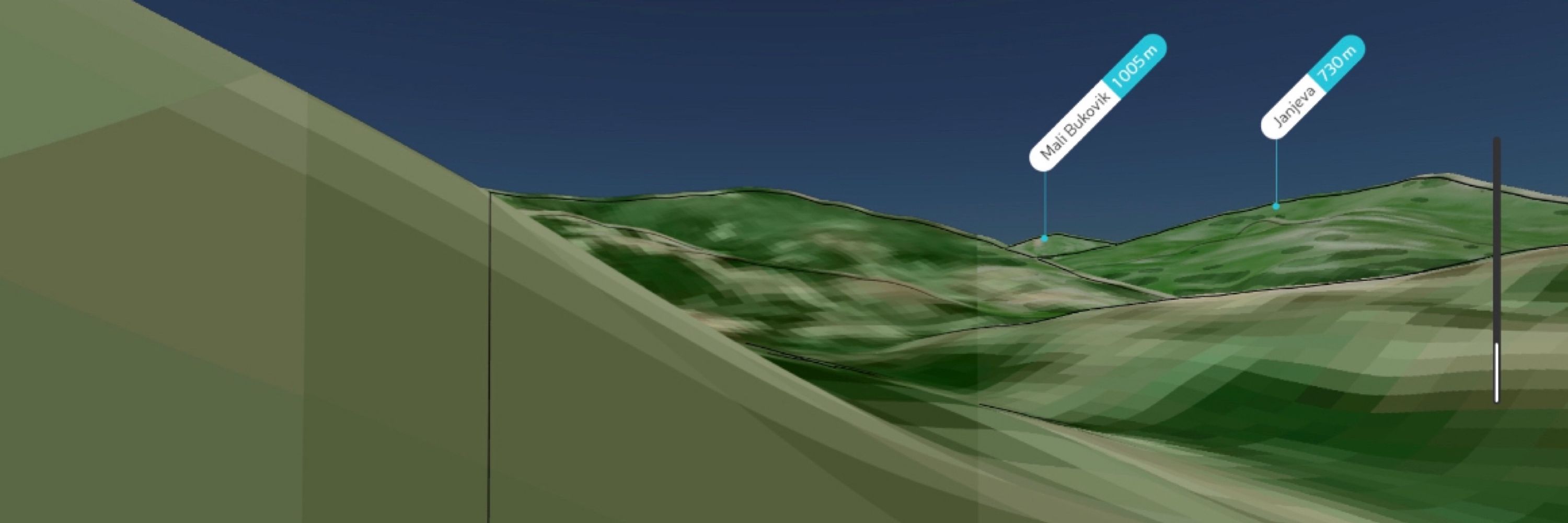
Taking alternate perspectives into account, it is very possible that these are the visible ridgelines. In this case, the valley still remains enough of a potential match to be worth investigation (in fact, it actually becomes a better match)
Taking alternate perspectives into account, it is very possible that these are the visible ridgelines. In this case, the valley still remains enough of a potential match to be worth investigation (in fact, it actually becomes a better match)
December 14, 2024 at 7:30 PM
Potential Correction:
Taking alternate perspectives into account, it is very possible that these are the visible ridgelines. In this case, the valley still remains enough of a potential match to be worth investigation (in fact, it actually becomes a better match)
Taking alternate perspectives into account, it is very possible that these are the visible ridgelines. In this case, the valley still remains enough of a potential match to be worth investigation (in fact, it actually becomes a better match)
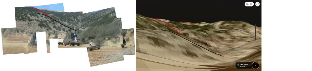
Finally, while severely hampered by the low resolution and a lack of clearly visible ridgelines in the video. The panorama seems to have remarkable similarities with peakvisor results. (5/8)

December 14, 2024 at 7:16 PM
Finally, while severely hampered by the low resolution and a lack of clearly visible ridgelines in the video. The panorama seems to have remarkable similarities with peakvisor results. (5/8)
This is further confirmed by some of the visible shrubbery in the valley's North, a near-perfect match with available satellite imagery. (4/8)


December 14, 2024 at 7:16 PM
This is further confirmed by some of the visible shrubbery in the valley's North, a near-perfect match with available satellite imagery. (4/8)
This Panorama (created by @thomasbordeaux.bsky.social), while hampered by the bad video quality, helps provide a better overview for geolocating.
Firstly, the surface places the location at the bottom of the valley. (3/8)
Firstly, the surface places the location at the bottom of the valley. (3/8)


December 14, 2024 at 7:16 PM
This Panorama (created by @thomasbordeaux.bsky.social), while hampered by the bad video quality, helps provide a better overview for geolocating.
Firstly, the surface places the location at the bottom of the valley. (3/8)
Firstly, the surface places the location at the bottom of the valley. (3/8)
It's not just any random valley, it is right next to a military base that appears to be home to one of the Syrian Special Forces Airborne Regiments. Furthermore, Israel bombed that base this month, highlighting its relevance. x.com/obretix/stat.... (2/8)


December 14, 2024 at 7:16 PM
It's not just any random valley, it is right next to a military base that appears to be home to one of the Syrian Special Forces Airborne Regiments. Furthermore, Israel bombed that base this month, highlighting its relevance. x.com/obretix/stat.... (2/8)
Austin Tice kidnapping video valley geolocation.
Local confirmation is needed.
The video of Austin Tice in 2012 shows few details. But in the Bellingcat discord, we think we have identified the specific valley at 33.511, 36.007. Damascus-based journalists could help investigate this further (1/8).
Local confirmation is needed.
The video of Austin Tice in 2012 shows few details. But in the Bellingcat discord, we think we have identified the specific valley at 33.511, 36.007. Damascus-based journalists could help investigate this further (1/8).

December 14, 2024 at 7:16 PM
Austin Tice kidnapping video valley geolocation.
Local confirmation is needed.
The video of Austin Tice in 2012 shows few details. But in the Bellingcat discord, we think we have identified the specific valley at 33.511, 36.007. Damascus-based journalists could help investigate this further (1/8).
Local confirmation is needed.
The video of Austin Tice in 2012 shows few details. But in the Bellingcat discord, we think we have identified the specific valley at 33.511, 36.007. Damascus-based journalists could help investigate this further (1/8).
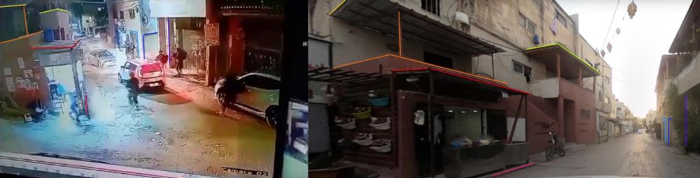
Geolocated Israeli soldiers moving into Jenin, 19/09/2023.
Coordinates: 32.46293738898866, 35.288196598921125
Source: t.me/a7rarjeninn/32…
Proof:
Coordinates: 32.46293738898866, 35.288196598921125
Source: t.me/a7rarjeninn/32…
Proof:
September 20, 2023 at 6:20 PM
Geolocated Israeli soldiers moving into Jenin, 19/09/2023.
Coordinates: 32.46293738898866, 35.288196598921125
Source: t.me/a7rarjeninn/32…
Proof:
Coordinates: 32.46293738898866, 35.288196598921125
Source: t.me/a7rarjeninn/32…
Proof:
Geolocated Israeli soldiers shooting at Journalists near Jabalia, 17/09/2023.
Coordinates: 31.5042565, 34.5219384
Source: t.me/jmediapal/68...
Proof (h/t @chrisosieck.bsky.social for the screenshots)
Coordinates: 31.5042565, 34.5219384
Source: t.me/jmediapal/68...
Proof (h/t @chrisosieck.bsky.social for the screenshots)


September 18, 2023 at 4:41 PM
Geolocated Israeli soldiers shooting at Journalists near Jabalia, 17/09/2023.
Coordinates: 31.5042565, 34.5219384
Source: t.me/jmediapal/68...
Proof (h/t @chrisosieck.bsky.social for the screenshots)
Coordinates: 31.5042565, 34.5219384
Source: t.me/jmediapal/68...
Proof (h/t @chrisosieck.bsky.social for the screenshots)
“Our camp, Our camp💔”
Israeli Bulldozer destroys a main road on the edge of Jenin RC in what looks like a potential repeat of the Battle of Jenin.
Coordinates: 32.4625940, 35.2875954
Source: https://t.me/jeninqassam/58133
Proof:
Israeli Bulldozer destroys a main road on the edge of Jenin RC in what looks like a potential repeat of the Battle of Jenin.
Coordinates: 32.4625940, 35.2875954
Source: https://t.me/jeninqassam/58133
Proof:

July 3, 2023 at 4:36 AM
“Our camp, Our camp💔”
Israeli Bulldozer destroys a main road on the edge of Jenin RC in what looks like a potential repeat of the Battle of Jenin.
Coordinates: 32.4625940, 35.2875954
Source: https://t.me/jeninqassam/58133
Proof:
Israeli Bulldozer destroys a main road on the edge of Jenin RC in what looks like a potential repeat of the Battle of Jenin.
Coordinates: 32.4625940, 35.2875954
Source: https://t.me/jeninqassam/58133
Proof: