


Dr. Sam McClatchie
@fishocean.bsky.social
Fisheries oceanographer (retired, NOAA Southwest Fisheries Science Center). Led the NOAA CalCOFI program for 11 years (2007-2011) prior to returning to New Zealand. Developer of Fishing Maps (www.fishingmaps.info).
There are times when the patterns of temperature on the ocean are simply beautiful, whether you are into the science or not.
www.fishingmaps.info
#fisheries #oceanography
www.fishingmaps.info
#fisheries #oceanography

August 22, 2025 at 8:31 AM
There are times when the patterns of temperature on the ocean are simply beautiful, whether you are into the science or not.
www.fishingmaps.info
#fisheries #oceanography
www.fishingmaps.info
#fisheries #oceanography
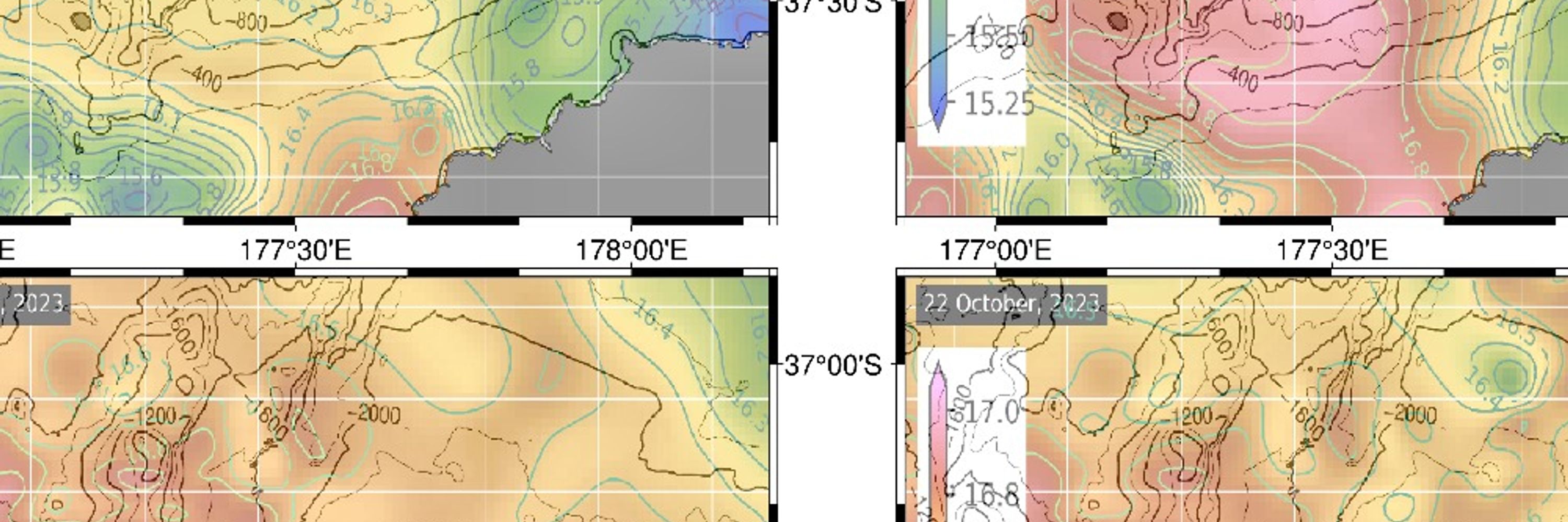
With return of sunny weather, the main recreational bluefin tuna fishing areas in New Zealand (Waihau Bay and Hokitika) are developing more complex surface temperature structure and fronts, and we are seeing some unusually clear chlorophyll imagery coming through. (www.fishingmaps.info). #fisheries


July 21, 2025 at 11:52 PM
With return of sunny weather, the main recreational bluefin tuna fishing areas in New Zealand (Waihau Bay and Hokitika) are developing more complex surface temperature structure and fronts, and we are seeing some unusually clear chlorophyll imagery coming through. (www.fishingmaps.info). #fisheries
Does anyone else think "What was I on?" when they start to refactor their code?
June 16, 2025 at 8:47 AM
Does anyone else think "What was I on?" when they start to refactor their code?
Most people don't realise that operational products require real people behind the scenes to keep things going smoothly.


March 2, 2025 at 10:41 PM
Most people don't realise that operational products require real people behind the scenes to keep things going smoothly.
Coincidence that NOAA NCEI and NOAA NWS websites are both experiencing difficulties? I certainly hope so.

February 9, 2025 at 3:32 AM
Coincidence that NOAA NCEI and NOAA NWS websites are both experiencing difficulties? I certainly hope so.
Would someone who has reliable information please tell me why the website for NOAA's National Center for Environmental Information is down? I'd love to be told there is a good reason not to be paranoid.

February 9, 2025 at 3:19 AM
Would someone who has reliable information please tell me why the website for NOAA's National Center for Environmental Information is down? I'd love to be told there is a good reason not to be paranoid.
We are only half way through the fishing season, so it looks like our startup will survive the second year. Of course we have invested in some expensive advertising this year, but we are hoping this will pay forward as we become a trusted supplier of quality maps.
#fisheries #oceanography
#fisheries #oceanography


January 31, 2025 at 7:55 PM
We are only half way through the fishing season, so it looks like our startup will survive the second year. Of course we have invested in some expensive advertising this year, but we are hoping this will pay forward as we become a trusted supplier of quality maps.
#fisheries #oceanography
#fisheries #oceanography

January 27, 2025 at 9:41 PM
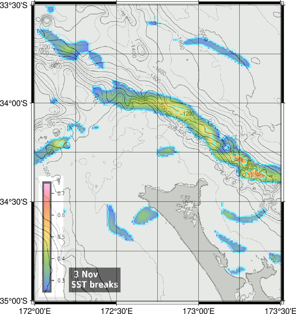
Explaining fronts to recreational big game fishers:
How do you know if a temperature break (or a front) is strong or weak? Ideally you want to target stronger fronts. Use the color scale on the temperature break map to help you decide if a front is strong enough to target.
#oceanography #fisheries
How do you know if a temperature break (or a front) is strong or weak? Ideally you want to target stronger fronts. Use the color scale on the temperature break map to help you decide if a front is strong enough to target.
#oceanography #fisheries


January 18, 2025 at 10:59 PM
Explaining fronts to recreational big game fishers:
How do you know if a temperature break (or a front) is strong or weak? Ideally you want to target stronger fronts. Use the color scale on the temperature break map to help you decide if a front is strong enough to target.
#oceanography #fisheries
How do you know if a temperature break (or a front) is strong or weak? Ideally you want to target stronger fronts. Use the color scale on the temperature break map to help you decide if a front is strong enough to target.
#oceanography #fisheries
This is an unusually clear image of Chlorophyll fronts off the Manukau Harbour on the west coast North Island of New Zealand. Data are a melded sensor product from Copernicus. Mapped by Fishing Maps for recreational big game fishing (www.fishingmaps.info).
#fisheries #oceanography
#fisheries #oceanography

January 10, 2025 at 11:30 PM
This is an unusually clear image of Chlorophyll fronts off the Manukau Harbour on the west coast North Island of New Zealand. Data are a melded sensor product from Copernicus. Mapped by Fishing Maps for recreational big game fishing (www.fishingmaps.info).
#fisheries #oceanography
#fisheries #oceanography
I'm wondering if my consistent blocking of bots & rubbish on my custom #Oceanography & #Fisheries feed is finally starting to work. Only one bot post today! It took a while to clean up my feed on Twitter too when I had an account ... I expected BlueSky to have fewer bots, but they are still a pest.

December 27, 2024 at 10:31 PM
I'm wondering if my consistent blocking of bots & rubbish on my custom #Oceanography & #Fisheries feed is finally starting to work. Only one bot post today! It took a while to clean up my feed on Twitter too when I had an account ... I expected BlueSky to have fewer bots, but they are still a pest.
The proofs for the second edition of my #CalCOFI book arrived yesterday. Which is pretty cool ... until you realise that you have to deal with each minute query from the publisher!
#fisheries #oceanography
#fisheries #oceanography


December 20, 2024 at 4:54 AM
The proofs for the second edition of my #CalCOFI book arrived yesterday. Which is pretty cool ... until you realise that you have to deal with each minute query from the publisher!
#fisheries #oceanography
#fisheries #oceanography
There's a new blog in the articles section of the Fishing Maps website explaining to gamefishers the effect of wind on the surface ocean temperature structure.
#fisheries
#oceanography
www.fishingmaps.info/articles/why...
#fisheries
#oceanography
www.fishingmaps.info/articles/why...


December 12, 2024 at 11:54 PM
There's a new blog in the articles section of the Fishing Maps website explaining to gamefishers the effect of wind on the surface ocean temperature structure.
#fisheries
#oceanography
www.fishingmaps.info/articles/why...
#fisheries
#oceanography
www.fishingmaps.info/articles/why...
A question:
If I block someone or a bot on my custom feed (Oceanography and Fisheries), does it block for everyone who views the feed, or just me? I'm trying to weed the rubbish that pops up and get the most useful feed.
If I block someone or a bot on my custom feed (Oceanography and Fisheries), does it block for everyone who views the feed, or just me? I'm trying to weed the rubbish that pops up and get the most useful feed.

December 5, 2024 at 5:15 AM
A question:
If I block someone or a bot on my custom feed (Oceanography and Fisheries), does it block for everyone who views the feed, or just me? I'm trying to weed the rubbish that pops up and get the most useful feed.
If I block someone or a bot on my custom feed (Oceanography and Fisheries), does it block for everyone who views the feed, or just me? I'm trying to weed the rubbish that pops up and get the most useful feed.
Animation of chlorophyll off Tutukaka, New Zealand. Data are from a #Copernicus melded sensor, 300m to 1km resolution, level 3, global product. I create these Fishing Maps (www.fishingmaps.info) in #python for use by the recreational sport #fishing community.
#fisheries #oceanography
#fisheries #oceanography
December 1, 2024 at 8:05 AM
Animation of chlorophyll off Tutukaka, New Zealand. Data are from a #Copernicus melded sensor, 300m to 1km resolution, level 3, global product. I create these Fishing Maps (www.fishingmaps.info) in #python for use by the recreational sport #fishing community.
#fisheries #oceanography
#fisheries #oceanography
If you are posting about #oceanography or #fisheries or both, please add these hashtags so your post will appear on the Oceanography and Fisheries custom feed.
November 30, 2024 at 3:59 AM
If you are posting about #oceanography or #fisheries or both, please add these hashtags so your post will appear on the Oceanography and Fisheries custom feed.
Hi Robbi -- I'd be pleased to be added, if appropriate.


November 20, 2024 at 7:21 AM
Hi Robbi -- I'd be pleased to be added, if appropriate.

If you are posting topics in fisheries, oceanography, and/ or fisheries oceanography, don't forget the
#fisheries
and
#oceanography
hashtags to be sure that your post will land on the Oceanography and Fisheries feed. And add the wave icon to get your post on the Oceanography feed.
#fisheries
and
#oceanography
hashtags to be sure that your post will land on the Oceanography and Fisheries feed. And add the wave icon to get your post on the Oceanography feed.


November 15, 2024 at 3:28 AM
If you are posting topics in fisheries, oceanography, and/ or fisheries oceanography, don't forget the
#fisheries
and
#oceanography
hashtags to be sure that your post will land on the Oceanography and Fisheries feed. And add the wave icon to get your post on the Oceanography feed.
#fisheries
and
#oceanography
hashtags to be sure that your post will land on the Oceanography and Fisheries feed. And add the wave icon to get your post on the Oceanography feed.
The Tutukaka, New Zealand maps (www.fishingmaps.info) show that there have been some good temperature breaks north of the Barrier over the last several days on the edge of a large patch of warm water, with transition from coastal to oceanic water.
#fisheries #oceanography #RemoteSensing #GHRSST
#fisheries #oceanography #RemoteSensing #GHRSST


November 8, 2024 at 6:40 AM
The Tutukaka, New Zealand maps (www.fishingmaps.info) show that there have been some good temperature breaks north of the Barrier over the last several days on the edge of a large patch of warm water, with transition from coastal to oceanic water.
#fisheries #oceanography #RemoteSensing #GHRSST
#fisheries #oceanography #RemoteSensing #GHRSST
"... Recent research since the last IPCC report does suggest that the IPCC has underestimated this risk and that the passing of this tipping point is a serious possibility already in the next few decades"
en.vedur.is/media/ads_in...
#oceanography #fisheries
en.vedur.is/media/ads_in...
#oceanography #fisheries

October 22, 2024 at 8:11 PM
"... Recent research since the last IPCC report does suggest that the IPCC has underestimated this risk and that the passing of this tipping point is a serious possibility already in the next few decades"
en.vedur.is/media/ads_in...
#oceanography #fisheries
en.vedur.is/media/ads_in...
#oceanography #fisheries
If you are posting about #fisheries or #oceanography, or both, don't forget to use the hashtags so your post will show up on the Oceanography& Fisheries feed.

October 22, 2024 at 7:51 PM
If you are posting about #fisheries or #oceanography, or both, don't forget to use the hashtags so your post will show up on the Oceanography& Fisheries feed.
That feeling when you you've been trying to figure out why a plot won't work and you finally realize that the array is empty ...

October 18, 2024 at 5:41 AM
That feeling when you you've been trying to figure out why a plot won't work and you finally realize that the array is empty ...
If you're posting anything to do with #oceanography or #fisheries, or both, don't forget to use the hashtags so your post will show up on the Oceanography&Fisheries feed.


October 9, 2024 at 8:27 PM
If you're posting anything to do with #oceanography or #fisheries, or both, don't forget to use the hashtags so your post will show up on the Oceanography&Fisheries feed.
Writing blogs for my game fishing map business is both a pleasure and a challenge because the audience is so different from the scientific forums I am so familiar with. I have to keep it short, focused on their interests, not too technical.
Latest blog:
www.fishingmaps.info/articles/fin...
Latest blog:
www.fishingmaps.info/articles/fin...

August 28, 2024 at 1:55 AM
Writing blogs for my game fishing map business is both a pleasure and a challenge because the audience is so different from the scientific forums I am so familiar with. I have to keep it short, focused on their interests, not too technical.
Latest blog:
www.fishingmaps.info/articles/fin...
Latest blog:
www.fishingmaps.info/articles/fin...