


Drew Tuma
@drewtuma.bsky.social
ABC7 Meteorologist | Penn State Grad
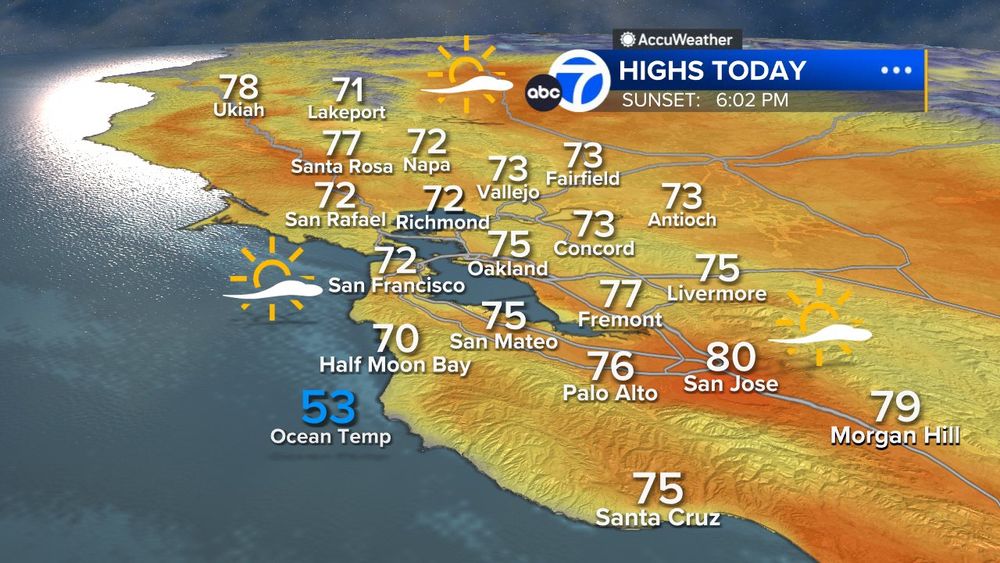
EVEN WARMER TODAY
If you didn't get a chance to enjoy yesterday's warm weather, today is going to be warmer. We keep it spring-like for another day with highs going into the 70s and 80s!😎
If you didn't get a chance to enjoy yesterday's warm weather, today is going to be warmer. We keep it spring-like for another day with highs going into the 70s and 80s!😎
February 27, 2025 at 1:38 PM
EVEN WARMER TODAY
If you didn't get a chance to enjoy yesterday's warm weather, today is going to be warmer. We keep it spring-like for another day with highs going into the 70s and 80s!😎
If you didn't get a chance to enjoy yesterday's warm weather, today is going to be warmer. We keep it spring-like for another day with highs going into the 70s and 80s!😎
PICTURE PERFECT
Sunny skies and warm temperatures today will make it feel like spring! Likely the first 70° day this year in San Francisco😎
Sunny skies and warm temperatures today will make it feel like spring! Likely the first 70° day this year in San Francisco😎

February 26, 2025 at 1:28 PM
PICTURE PERFECT
Sunny skies and warm temperatures today will make it feel like spring! Likely the first 70° day this year in San Francisco😎
Sunny skies and warm temperatures today will make it feel like spring! Likely the first 70° day this year in San Francisco😎
The last seven days have been very rainy across Northern California. A look at the rainfall totals across the Bay Area. Some areas have seen more than a foot of rain in the North Bay.

February 7, 2025 at 7:23 PM
The last seven days have been very rainy across Northern California. A look at the rainfall totals across the Bay Area. Some areas have seen more than a foot of rain in the North Bay.
Rain is back today! LiveDoppler7 showing you our storm on approach with rain returning to your neighborhood by 8am this morning. Rain will be on and off all day. Winds will be strong this afternoon with gusts 25-50mph. This is a level 2 moderate storm on the Storm Impact Scale.
February 6, 2025 at 1:28 PM
Rain is back today! LiveDoppler7 showing you our storm on approach with rain returning to your neighborhood by 8am this morning. Rain will be on and off all day. Winds will be strong this afternoon with gusts 25-50mph. This is a level 2 moderate storm on the Storm Impact Scale.
If you have the ability to work from home, today would be perfect day to do it. Heavy rain this morning has already led to numerous roads seeing flooding. More heavy rain and strong winds arrive later this afternoon. Worst of the storm will be between 1pm-7pm today.

February 4, 2025 at 1:03 PM
If you have the ability to work from home, today would be perfect day to do it. Heavy rain this morning has already led to numerous roads seeing flooding. More heavy rain and strong winds arrive later this afternoon. Worst of the storm will be between 1pm-7pm today.
FLOOD RISK SATURDAY
As our soil becomes saturated Friday, heavier rain on Saturday could lead to nuisance flooding on roads and smaller streams and creeks. The entire Bay Area is outlined for the increased risk of flooding Saturday.
As our soil becomes saturated Friday, heavier rain on Saturday could lead to nuisance flooding on roads and smaller streams and creeks. The entire Bay Area is outlined for the increased risk of flooding Saturday.

January 30, 2025 at 5:42 PM
FLOOD RISK SATURDAY
As our soil becomes saturated Friday, heavier rain on Saturday could lead to nuisance flooding on roads and smaller streams and creeks. The entire Bay Area is outlined for the increased risk of flooding Saturday.
As our soil becomes saturated Friday, heavier rain on Saturday could lead to nuisance flooding on roads and smaller streams and creeks. The entire Bay Area is outlined for the increased risk of flooding Saturday.
STORM PREPS TODAY
Get everything in order: clear those gutters/storm drains, secure outdoor objects, check/trim trees. Rain returns Friday and intensifies Saturday with a moderate strength atmospheric river. Winds will also be gusty Saturday morning between 20-40mph.
Get everything in order: clear those gutters/storm drains, secure outdoor objects, check/trim trees. Rain returns Friday and intensifies Saturday with a moderate strength atmospheric river. Winds will also be gusty Saturday morning between 20-40mph.

January 30, 2025 at 1:33 PM
STORM PREPS TODAY
Get everything in order: clear those gutters/storm drains, secure outdoor objects, check/trim trees. Rain returns Friday and intensifies Saturday with a moderate strength atmospheric river. Winds will also be gusty Saturday morning between 20-40mph.
Get everything in order: clear those gutters/storm drains, secure outdoor objects, check/trim trees. Rain returns Friday and intensifies Saturday with a moderate strength atmospheric river. Winds will also be gusty Saturday morning between 20-40mph.
TRENDING WETTER
Rain returns Friday morning with light showers throughout the day. Our stormy pattern will likely stick around into most of next week and the latest guidance has some of the heaviest rain falling across the Bay Area. An early look at rainfall totals next 7 days.
Rain returns Friday morning with light showers throughout the day. Our stormy pattern will likely stick around into most of next week and the latest guidance has some of the heaviest rain falling across the Bay Area. An early look at rainfall totals next 7 days.

January 29, 2025 at 1:28 PM
TRENDING WETTER
Rain returns Friday morning with light showers throughout the day. Our stormy pattern will likely stick around into most of next week and the latest guidance has some of the heaviest rain falling across the Bay Area. An early look at rainfall totals next 7 days.
Rain returns Friday morning with light showers throughout the day. Our stormy pattern will likely stick around into most of next week and the latest guidance has some of the heaviest rain falling across the Bay Area. An early look at rainfall totals next 7 days.
Confidence is growing that rain will return by the end of the week and stick around for several days. The Climate Prediction Center has place much of the west under a better than average chance of seeing a stormy pattern return as we head into February.


January 27, 2025 at 2:07 PM
Confidence is growing that rain will return by the end of the week and stick around for several days. The Climate Prediction Center has place much of the west under a better than average chance of seeing a stormy pattern return as we head into February.
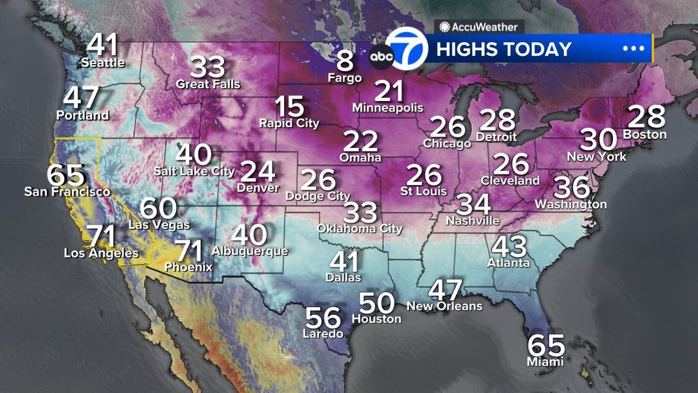
San Francisco is one of the warmest places in the entire U.S. this morning

January 23, 2025 at 2:53 PM
San Francisco is one of the warmest places in the entire U.S. this morning
California is experiencing strong offshore winds next few days🌬️Bay Area will see gusts 30-50mph. Across Southern California a rare January Red Flag Warning is posted. Winds in the mountains of LA/Ventura county could gust near 100mph creating life-threatening extreme fire danger

January 7, 2025 at 4:00 PM
California is experiencing strong offshore winds next few days🌬️Bay Area will see gusts 30-50mph. Across Southern California a rare January Red Flag Warning is posted. Winds in the mountains of LA/Ventura county could gust near 100mph creating life-threatening extreme fire danger
Arctic air has take over much of the county except for California. San Francisco will be just as warm as Miami today.
January 7, 2025 at 2:33 PM
Arctic air has take over much of the county except for California. San Francisco will be just as warm as Miami today.
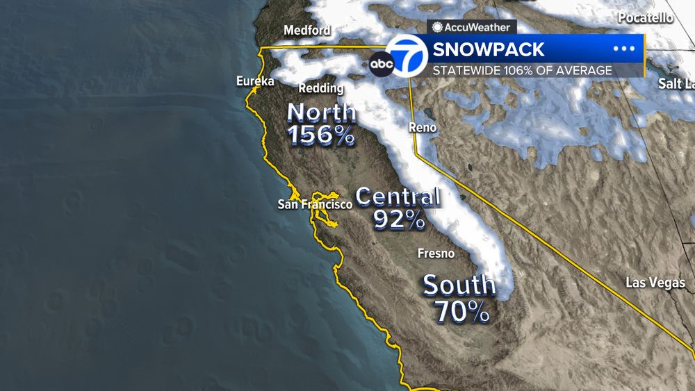
Our snow pack is in much better shape than last year. 1st snow survey of the season found a snow pack 91% of average (contrast that to just 35% of average same time last year). Northern Sierra better than Southern Sierra due to storm track favoring Northern California (4/4)
January 6, 2025 at 3:38 PM
Our snow pack is in much better shape than last year. 1st snow survey of the season found a snow pack 91% of average (contrast that to just 35% of average same time last year). Northern Sierra better than Southern Sierra due to storm track favoring Northern California (4/4)
Southern California has barely seen any rain this season. Cities like Los Angeles and San Diego are significantly dry this year. A rare January Red Flag Warning will be in effect this week due to very dry conditions and winds gusts 50mph+. (3/4)


January 6, 2025 at 3:38 PM
Southern California has barely seen any rain this season. Cities like Los Angeles and San Diego are significantly dry this year. A rare January Red Flag Warning will be in effect this week due to very dry conditions and winds gusts 50mph+. (3/4)
The Bay Area is in decent shape this winter. Many cities are above average/near average for rainfall totals. However, San Jose is running below average due to the storm track favoring the North Bay (think flooding rains from weeks past). (2/4)

January 6, 2025 at 3:38 PM
The Bay Area is in decent shape this winter. Many cities are above average/near average for rainfall totals. However, San Jose is running below average due to the storm track favoring the North Bay (think flooding rains from weeks past). (2/4)
WINTER RAINFALL CHECK
Massive contrast in rainfall totals across California so far this winter as the storm track has favored the northern half of the state. Places across Southern California have barely seen a drop of rain this season (1/4)
Massive contrast in rainfall totals across California so far this winter as the storm track has favored the northern half of the state. Places across Southern California have barely seen a drop of rain this season (1/4)

January 6, 2025 at 3:38 PM
WINTER RAINFALL CHECK
Massive contrast in rainfall totals across California so far this winter as the storm track has favored the northern half of the state. Places across Southern California have barely seen a drop of rain this season (1/4)
Massive contrast in rainfall totals across California so far this winter as the storm track has favored the northern half of the state. Places across Southern California have barely seen a drop of rain this season (1/4)
RAIN RETURNS TONIGHT
Our weeks long dry stretch will come to an end later this evening with a level 1 light storm on the ABC7 storm impact scale. While the sun is up Wednesday we will remain dry. Steadiest rain occurs around midnight. .25" - .75" total rainfall expected.
Our weeks long dry stretch will come to an end later this evening with a level 1 light storm on the ABC7 storm impact scale. While the sun is up Wednesday we will remain dry. Steadiest rain occurs around midnight. .25" - .75" total rainfall expected.

December 11, 2024 at 2:11 PM
RAIN RETURNS TONIGHT
Our weeks long dry stretch will come to an end later this evening with a level 1 light storm on the ABC7 storm impact scale. While the sun is up Wednesday we will remain dry. Steadiest rain occurs around midnight. .25" - .75" total rainfall expected.
Our weeks long dry stretch will come to an end later this evening with a level 1 light storm on the ABC7 storm impact scale. While the sun is up Wednesday we will remain dry. Steadiest rain occurs around midnight. .25" - .75" total rainfall expected.
ONE MORE WET MORNING
We have scattered showers this morning that will end later this afternoon.
Skies will clear overnight tonight for a sunny and dry pattern starting tomorrow.
Having Thanksgiving outside? You'll be good to go with full sunshine on Thursday
We have scattered showers this morning that will end later this afternoon.
Skies will clear overnight tonight for a sunny and dry pattern starting tomorrow.
Having Thanksgiving outside? You'll be good to go with full sunshine on Thursday
November 26, 2024 at 1:34 PM
ONE MORE WET MORNING
We have scattered showers this morning that will end later this afternoon.
Skies will clear overnight tonight for a sunny and dry pattern starting tomorrow.
Having Thanksgiving outside? You'll be good to go with full sunshine on Thursday
We have scattered showers this morning that will end later this afternoon.
Skies will clear overnight tonight for a sunny and dry pattern starting tomorrow.
Having Thanksgiving outside? You'll be good to go with full sunshine on Thursday
MORNING SHOWERS
LiveDoppler7 showing light rain falling across most of the Bay Area this morning.
There is no risk for flooding like we saw last week but you will see standing water on our roads leading to slower travel times.
Best chance for rain will be before noon today.
LiveDoppler7 showing light rain falling across most of the Bay Area this morning.
There is no risk for flooding like we saw last week but you will see standing water on our roads leading to slower travel times.
Best chance for rain will be before noon today.

November 25, 2024 at 2:06 PM
MORNING SHOWERS
LiveDoppler7 showing light rain falling across most of the Bay Area this morning.
There is no risk for flooding like we saw last week but you will see standing water on our roads leading to slower travel times.
Best chance for rain will be before noon today.
LiveDoppler7 showing light rain falling across most of the Bay Area this morning.
There is no risk for flooding like we saw last week but you will see standing water on our roads leading to slower travel times.
Best chance for rain will be before noon today.
Our atmospheric river is finally on the move!
LiveDoppler7 showing heavy rain is moving across much of the Bay Area this morning.
Expect the heaviest rain to actually fall outside of the North Bay this afternoon and evening where we expect 1"-3"+ across San Francisco, Oakland and San Jose.
LiveDoppler7 showing heavy rain is moving across much of the Bay Area this morning.
Expect the heaviest rain to actually fall outside of the North Bay this afternoon and evening where we expect 1"-3"+ across San Francisco, Oakland and San Jose.

November 22, 2024 at 6:47 PM
Our atmospheric river is finally on the move!
LiveDoppler7 showing heavy rain is moving across much of the Bay Area this morning.
Expect the heaviest rain to actually fall outside of the North Bay this afternoon and evening where we expect 1"-3"+ across San Francisco, Oakland and San Jose.
LiveDoppler7 showing heavy rain is moving across much of the Bay Area this morning.
Expect the heaviest rain to actually fall outside of the North Bay this afternoon and evening where we expect 1"-3"+ across San Francisco, Oakland and San Jose.