


Daisy Brunt
@daisybrunt.bsky.social
Mesopotamian Archaeologist
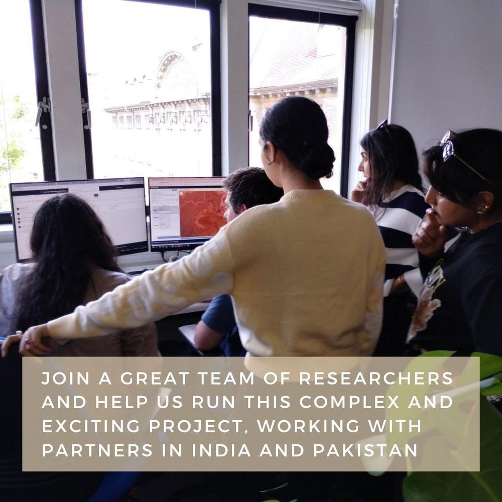
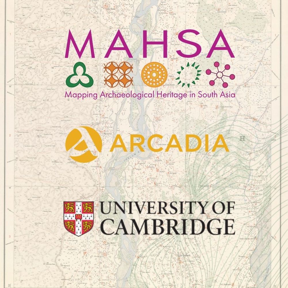
Mapping Archaeological Heritage South Asia Project @University of Cambridge
@mahsa-project.bsky.social
Mapping Archaeological Heritage South Asia Project @University of Cambridge
@mahsa-project.bsky.social
Reposted by Daisy Brunt

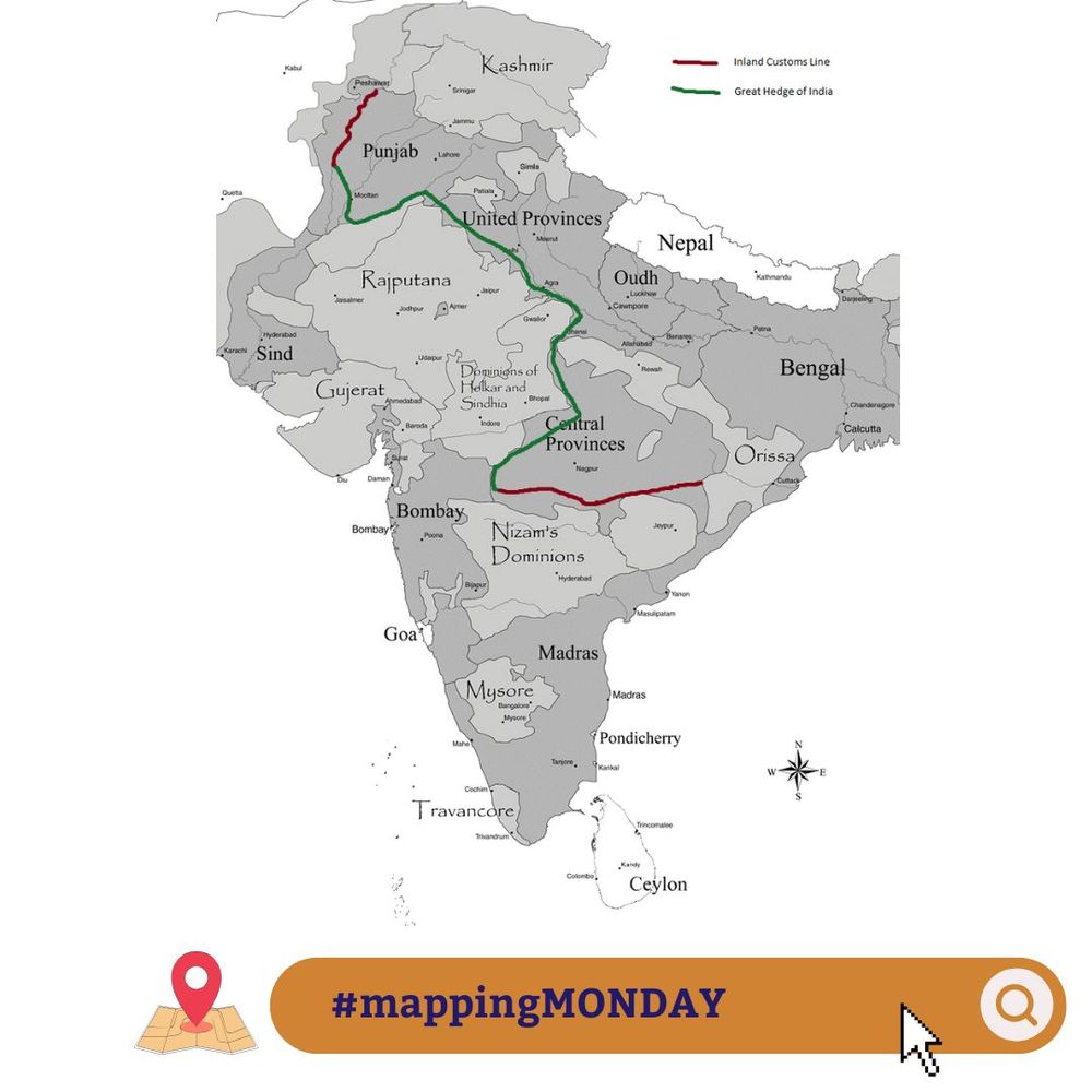
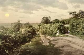
#MappingMonday we are looking again at the British Colonial Inland Customs Line constructed using native shrubs and designed to prevent people, especially salt smugglers from passing through it. It was eventually abandoned after colonial powers took complete control of salt production. (1/2)
July 15, 2025 at 10:07 AM
#MappingMonday we are looking again at the British Colonial Inland Customs Line constructed using native shrubs and designed to prevent people, especially salt smugglers from passing through it. It was eventually abandoned after colonial powers took complete control of salt production. (1/2)
Reposted by Daisy Brunt
The Inland Customs Line was a barrier built in India to prevent the smuggling of salt and maintain the British monopoly on its sale. It was first established in Bengal in 1803 and grew to cover more than 4000km. The line was made of a 12ft high living hedge with staff patrolling its length (2/4)
July 10, 2025 at 12:48 PM
The Inland Customs Line was a barrier built in India to prevent the smuggling of salt and maintain the British monopoly on its sale. It was first established in Bengal in 1803 and grew to cover more than 4000km. The line was made of a 12ft high living hedge with staff patrolling its length (2/4)
Reposted by Daisy Brunt
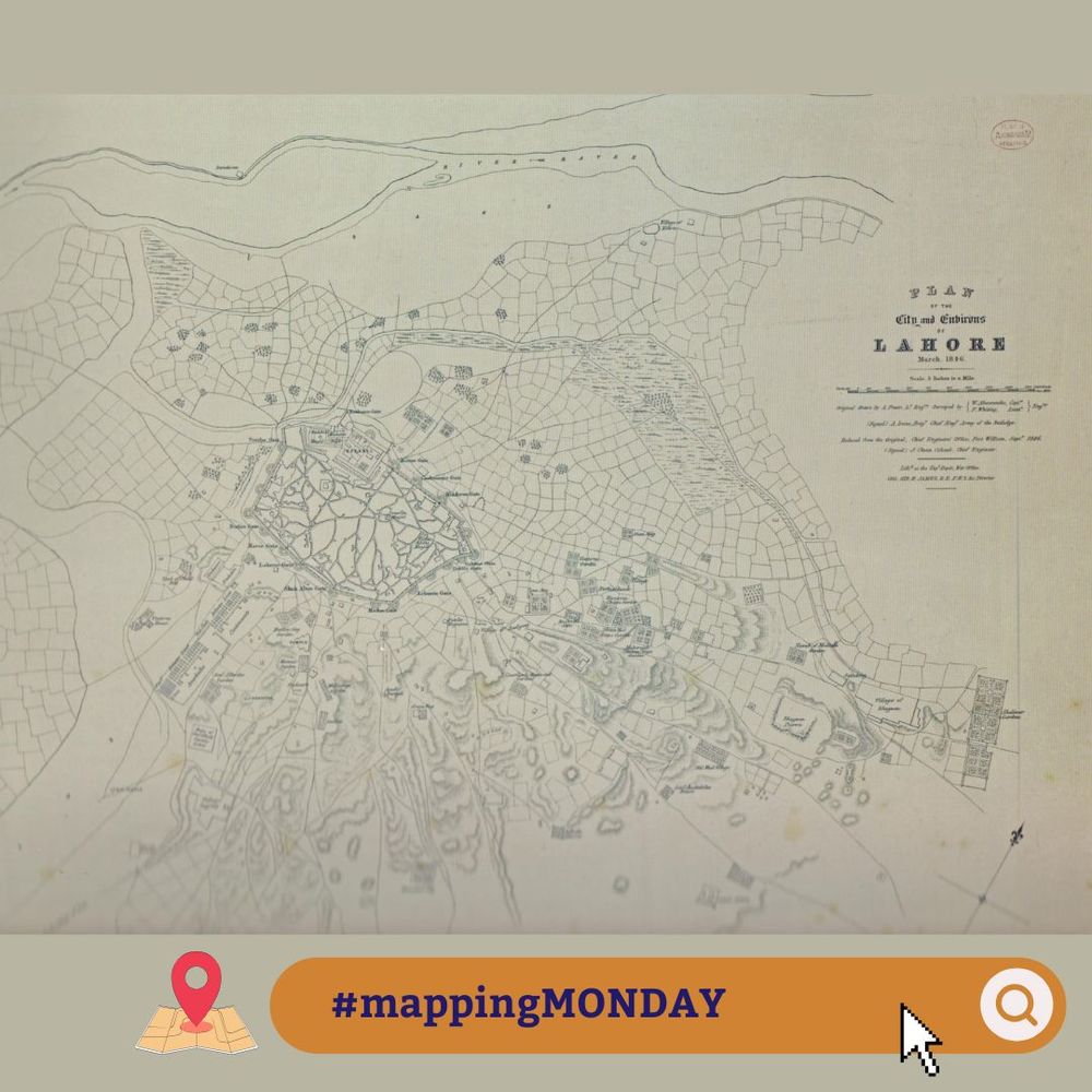
#MappingMonday we’re examining the history of Lahore through it’s early cartography. The map presented here is an early example of the British colonial maps of Pakistan during the tumultuous 1840s. (1/3)
'Mapping Lahore: Tracing historical geography of a city through maps' by Dr Abdul Rehman (2013)
'Mapping Lahore: Tracing historical geography of a city through maps' by Dr Abdul Rehman (2013)
July 7, 2025 at 3:32 PM
#MappingMonday we’re examining the history of Lahore through it’s early cartography. The map presented here is an early example of the British colonial maps of Pakistan during the tumultuous 1840s. (1/3)
'Mapping Lahore: Tracing historical geography of a city through maps' by Dr Abdul Rehman (2013)
'Mapping Lahore: Tracing historical geography of a city through maps' by Dr Abdul Rehman (2013)
Reposted by Daisy Brunt
Position OPEN! MAHSA is hiring a new 'Project Administrator' to help us achieve our goals. Full time, fixed term (until 30/06/29) based at Cambridge.
DEADLINE:20/07/25
Apply here:
www.jobs.cam.ac.uk/job/51769/
#job #newhire #career #admin #cambridge #universityofcambridge #archaeology
DEADLINE:20/07/25
Apply here:
www.jobs.cam.ac.uk/job/51769/
#job #newhire #career #admin #cambridge #universityofcambridge #archaeology

June 20, 2025 at 3:28 PM
Position OPEN! MAHSA is hiring a new 'Project Administrator' to help us achieve our goals. Full time, fixed term (until 30/06/29) based at Cambridge.
DEADLINE:20/07/25
Apply here:
www.jobs.cam.ac.uk/job/51769/
#job #newhire #career #admin #cambridge #universityofcambridge #archaeology
DEADLINE:20/07/25
Apply here:
www.jobs.cam.ac.uk/job/51769/
#job #newhire #career #admin #cambridge #universityofcambridge #archaeology
Reposted by Daisy Brunt
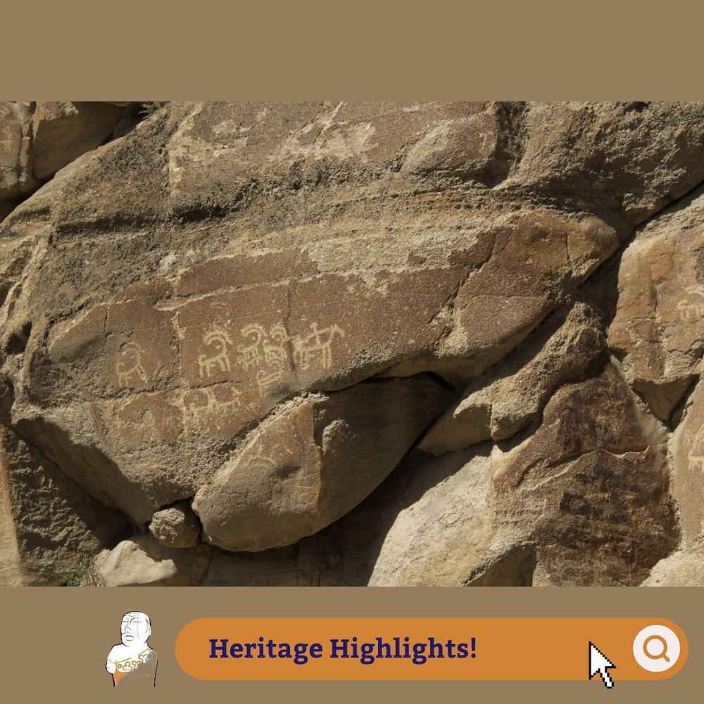
For this week’s #heritagehighlights we’re looking at the Sacred Rocks of Hunza which are located along the route of the ancient Silk Road in Gilgit-Baltistan in northern Pakistan. The site consists of four main boulders which feature two separate phases of engravings covering a 180m stretch (1/3).
June 20, 2025 at 9:42 AM
For this week’s #heritagehighlights we’re looking at the Sacred Rocks of Hunza which are located along the route of the ancient Silk Road in Gilgit-Baltistan in northern Pakistan. The site consists of four main boulders which feature two separate phases of engravings covering a 180m stretch (1/3).
Reposted by Daisy Brunt
#HeritageHighlights
🎤Today, South Asian Women in the Field (SAWIF) recorded their first #podcast in the series.
In conversation with Prof Rajani we discussed the changing field of remote sensing #archaeology and what its like for women in this field.
Stay tuned for the release!
🎤Today, South Asian Women in the Field (SAWIF) recorded their first #podcast in the series.
In conversation with Prof Rajani we discussed the changing field of remote sensing #archaeology and what its like for women in this field.
Stay tuned for the release!

June 12, 2025 at 11:47 AM
#HeritageHighlights
🎤Today, South Asian Women in the Field (SAWIF) recorded their first #podcast in the series.
In conversation with Prof Rajani we discussed the changing field of remote sensing #archaeology and what its like for women in this field.
Stay tuned for the release!
🎤Today, South Asian Women in the Field (SAWIF) recorded their first #podcast in the series.
In conversation with Prof Rajani we discussed the changing field of remote sensing #archaeology and what its like for women in this field.
Stay tuned for the release!
Reposted by Daisy Brunt
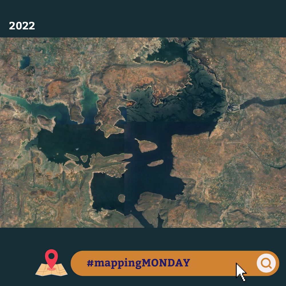
The Nagarjuna Sagar Dam is one of the largest masonry dams in the world, providing crucial irrigation waters to its surrounding districts as well as green electricity generation for India’s national grid. Its construction in 1955 heralded the beginning of India’s Green Revolution (1/4)
June 9, 2025 at 3:42 PM
The Nagarjuna Sagar Dam is one of the largest masonry dams in the world, providing crucial irrigation waters to its surrounding districts as well as green electricity generation for India’s national grid. Its construction in 1955 heralded the beginning of India’s Green Revolution (1/4)
Reposted by Daisy Brunt
Our visiting scholar Professor MB Rajani is presenting "Uncovering Mughal Agra: Riverfront Gardens, City Walls, and Urban Transformations through Remote Sensing and GIS" next week.
Please come along to the McDonald Institute if you are in Cambridge or via Zoom 👇
cam-ac-uk.zoom.us/meeting/regi...
Please come along to the McDonald Institute if you are in Cambridge or via Zoom 👇
cam-ac-uk.zoom.us/meeting/regi...

June 4, 2025 at 3:50 PM
Our visiting scholar Professor MB Rajani is presenting "Uncovering Mughal Agra: Riverfront Gardens, City Walls, and Urban Transformations through Remote Sensing and GIS" next week.
Please come along to the McDonald Institute if you are in Cambridge or via Zoom 👇
cam-ac-uk.zoom.us/meeting/regi...
Please come along to the McDonald Institute if you are in Cambridge or via Zoom 👇
cam-ac-uk.zoom.us/meeting/regi...
Reposted by Daisy Brunt
#MappingMonday This structure lies about 40km east of Bahawalpur in Pakistan. It is labelled “Kureemdad Kote” in the Punjab Revenue Survey legacy data maps but not recorded elsewhere in the literature. As you can see is also just about visible in the modern satellite photographs. (1/3)


May 19, 2025 at 1:08 PM
#MappingMonday This structure lies about 40km east of Bahawalpur in Pakistan. It is labelled “Kureemdad Kote” in the Punjab Revenue Survey legacy data maps but not recorded elsewhere in the literature. As you can see is also just about visible in the modern satellite photographs. (1/3)
Reposted by Daisy Brunt
#HeritageHighlights
The Sindh region of Pakistan is a region rich in lithic sources including chert which has been exploited since the Palaeolithic period. We can see evidence of this and the chaîne opératoire of tool production in the preservation of mines, chipping floors and workshops. (1/4)
The Sindh region of Pakistan is a region rich in lithic sources including chert which has been exploited since the Palaeolithic period. We can see evidence of this and the chaîne opératoire of tool production in the preservation of mines, chipping floors and workshops. (1/4)


May 15, 2025 at 8:53 AM
#HeritageHighlights
The Sindh region of Pakistan is a region rich in lithic sources including chert which has been exploited since the Palaeolithic period. We can see evidence of this and the chaîne opératoire of tool production in the preservation of mines, chipping floors and workshops. (1/4)
The Sindh region of Pakistan is a region rich in lithic sources including chert which has been exploited since the Palaeolithic period. We can see evidence of this and the chaîne opératoire of tool production in the preservation of mines, chipping floors and workshops. (1/4)
Reposted by Daisy Brunt
#HeritageHighlights we’re discussing a topical issue concerning the auction of ancient Indian gems called the Piprahwa gems. The Piprahwa gems were uncovered at Piprahwa, an archaeological site in India dating to the 3rd century BCE, where the partial remains of the Buddha were buried. (1/4)

May 8, 2025 at 3:53 PM
#HeritageHighlights we’re discussing a topical issue concerning the auction of ancient Indian gems called the Piprahwa gems. The Piprahwa gems were uncovered at Piprahwa, an archaeological site in India dating to the 3rd century BCE, where the partial remains of the Buddha were buried. (1/4)
Reposted by Daisy Brunt
#Heritagehighlights! The site of Raipur consists of 262 stone circles created with megaliths built by mobile pastoralists in 8th-5th century BCE. Inside the circles are human remains, metal fragments and weapons and butchered horse bones.
Why do you think these structures were built?
Why do you think these structures were built?

May 1, 2025 at 1:44 PM
#Heritagehighlights! The site of Raipur consists of 262 stone circles created with megaliths built by mobile pastoralists in 8th-5th century BCE. Inside the circles are human remains, metal fragments and weapons and butchered horse bones.
Why do you think these structures were built?
Why do you think these structures were built?
Reposted by Daisy Brunt
Happy #MappingMonday This week we are looking at Amlukdara stupa, a 3rd century Buddhist stupa located in Swat Valley, Pakistan and surveyed by Aurel Stein in 1926. One of many Buddhist religious structures built along the Silk Road in Udyāna, its strategic position connected India to Central Asia.


April 28, 2025 at 3:59 PM
Happy #MappingMonday This week we are looking at Amlukdara stupa, a 3rd century Buddhist stupa located in Swat Valley, Pakistan and surveyed by Aurel Stein in 1926. One of many Buddhist religious structures built along the Silk Road in Udyāna, its strategic position connected India to Central Asia.
Reposted by Daisy Brunt
#HeritageHighlight This glazed slipware from the Indus Valley late Harappan period shows expert craftsmanship. Electron microscopy reveals it was made using multiple clays, reflecting specialised knowledge and access to resources which was likely a marker of status or access to elite goods.

April 24, 2025 at 9:54 AM
#HeritageHighlight This glazed slipware from the Indus Valley late Harappan period shows expert craftsmanship. Electron microscopy reveals it was made using multiple clays, reflecting specialised knowledge and access to resources which was likely a marker of status or access to elite goods.
Reposted by Daisy Brunt
#HeritageHighlight
Balangoda Man are hominids from Sri Lanka’s late Quaternary period dating to 38,000 BC. This population decorated themselves with beads made from fish bones, seashells and shark vertebra. Locations of sea-procured products indicates extensive intra-regional connections over 40km
Balangoda Man are hominids from Sri Lanka’s late Quaternary period dating to 38,000 BC. This population decorated themselves with beads made from fish bones, seashells and shark vertebra. Locations of sea-procured products indicates extensive intra-regional connections over 40km

April 17, 2025 at 8:26 AM
#HeritageHighlight
Balangoda Man are hominids from Sri Lanka’s late Quaternary period dating to 38,000 BC. This population decorated themselves with beads made from fish bones, seashells and shark vertebra. Locations of sea-procured products indicates extensive intra-regional connections over 40km
Balangoda Man are hominids from Sri Lanka’s late Quaternary period dating to 38,000 BC. This population decorated themselves with beads made from fish bones, seashells and shark vertebra. Locations of sea-procured products indicates extensive intra-regional connections over 40km
Reposted by Daisy Brunt
Last week, the MAHSA team brought the fun to the Cambridge Festival, spending a fantastic few hours showing off our project and the exciting work we do!
One of the highlights? Our new AR Sandbox! With a bit of high-tech magic it allows the user to shape sand into digital topographic maps!
#heritage
One of the highlights? Our new AR Sandbox! With a bit of high-tech magic it allows the user to shape sand into digital topographic maps!
#heritage


April 3, 2025 at 9:41 AM
Last week, the MAHSA team brought the fun to the Cambridge Festival, spending a fantastic few hours showing off our project and the exciting work we do!
One of the highlights? Our new AR Sandbox! With a bit of high-tech magic it allows the user to shape sand into digital topographic maps!
#heritage
One of the highlights? Our new AR Sandbox! With a bit of high-tech magic it allows the user to shape sand into digital topographic maps!
#heritage
Reposted by Daisy Brunt
Eid Mubarak!
#MappingMonday
Map making has a long history in Islam, owing to the practice of qibla which requires all prayers and mosques to face Mecca. Two 17th Century maps used to find the direction and distance to Mecca. The grid reveals markers with Mecca at the centre of a world-map.
#MappingMonday
Map making has a long history in Islam, owing to the practice of qibla which requires all prayers and mosques to face Mecca. Two 17th Century maps used to find the direction and distance to Mecca. The grid reveals markers with Mecca at the centre of a world-map.


March 31, 2025 at 2:30 PM
Eid Mubarak!
#MappingMonday
Map making has a long history in Islam, owing to the practice of qibla which requires all prayers and mosques to face Mecca. Two 17th Century maps used to find the direction and distance to Mecca. The grid reveals markers with Mecca at the centre of a world-map.
#MappingMonday
Map making has a long history in Islam, owing to the practice of qibla which requires all prayers and mosques to face Mecca. Two 17th Century maps used to find the direction and distance to Mecca. The grid reveals markers with Mecca at the centre of a world-map.
Reposted by Daisy Brunt
Dhinodhar hill is a volcanic plug in Gujarat, India. A volcanic plug is created when magma hardens. On its highest peak there is a shrine built in 1821 seen on this Survey of India map. It is now a tourist and pilgrimage site which showcases the beautiful views of the Chhari Dhandh wetland.


March 25, 2025 at 9:27 AM
Dhinodhar hill is a volcanic plug in Gujarat, India. A volcanic plug is created when magma hardens. On its highest peak there is a shrine built in 1821 seen on this Survey of India map. It is now a tourist and pilgrimage site which showcases the beautiful views of the Chhari Dhandh wetland.
Reposted by Daisy Brunt
For #MappingModay we’re looking at some recent work from MAHSA research assistant, @vaneshreev.bsky.social . Her paper on mapping the Indian Palaeolithic explores the use of GIS and computational methods in the use of #legacydatasets in #archaeology.
👇
journal.caa-international.org/articles/10....
👇
journal.caa-international.org/articles/10....


March 10, 2025 at 4:23 PM
For #MappingModay we’re looking at some recent work from MAHSA research assistant, @vaneshreev.bsky.social . Her paper on mapping the Indian Palaeolithic explores the use of GIS and computational methods in the use of #legacydatasets in #archaeology.
👇
journal.caa-international.org/articles/10....
👇
journal.caa-international.org/articles/10....
Reposted by Daisy Brunt
#heritagehighlights we’re looking at the Painted Grey Ware Culture of the Iron Age in the Indus Valley which was first identified at Hatinapura and dates to 1100-800 BCE. Examples have been found at sites as far as the Himalayas meaning this culture spanned 900km, matching the Indus Civilisation.

February 27, 2025 at 1:59 PM
#heritagehighlights we’re looking at the Painted Grey Ware Culture of the Iron Age in the Indus Valley which was first identified at Hatinapura and dates to 1100-800 BCE. Examples have been found at sites as far as the Himalayas meaning this culture spanned 900km, matching the Indus Civilisation.
Reposted by Daisy Brunt
#HeritageHighlight The Abbasi Royal Graveyard in Bahawalpur, Pakistan, which MAHSA visited during a recent training trip. The Abbasi family was the ruling Nawab family of Bahawalpur, whose dynasty ruled there from the 18th century until the state’s accession to Pakistan in 1955.


February 20, 2025 at 12:01 PM
#HeritageHighlight The Abbasi Royal Graveyard in Bahawalpur, Pakistan, which MAHSA visited during a recent training trip. The Abbasi family was the ruling Nawab family of Bahawalpur, whose dynasty ruled there from the 18th century until the state’s accession to Pakistan in 1955.
Reposted by Daisy Brunt
#MappingMonday - This map of the water sources in Gujarat, India. Water is an essential component in the history of settlement patterns. Therefore, these maps are helpful in heritage management helping projects to understand water use and the conditions for occupation, geology and sediment erosion.

February 17, 2025 at 4:38 PM
#MappingMonday - This map of the water sources in Gujarat, India. Water is an essential component in the history of settlement patterns. Therefore, these maps are helpful in heritage management helping projects to understand water use and the conditions for occupation, geology and sediment erosion.
Reposted by Daisy Brunt
On Monday, we welcomed the family of Rai Bahadur Lal Singh to Cambridge! Singh was a Daffadar in the British Indian Army who joined the Survey of India in 1895 as a valued surveyor. If you'd like to read more about Singh's work click the link below.
storymaps.arcgis.com/stories/16b9...
storymaps.arcgis.com/stories/16b9...


January 30, 2025 at 11:06 AM
On Monday, we welcomed the family of Rai Bahadur Lal Singh to Cambridge! Singh was a Daffadar in the British Indian Army who joined the Survey of India in 1895 as a valued surveyor. If you'd like to read more about Singh's work click the link below.
storymaps.arcgis.com/stories/16b9...
storymaps.arcgis.com/stories/16b9...