


Alex Boreham
@cyclonicwx.bsky.social
Tropical meteorologist, B.S. FSU, amateur web, Python, & GrADS programmer.
Also known as Not Sparta
Also known as Not Sparta
With this system pulling to the east, the northerly flow behind is producing a lot of lake effect snow off Lakes Michigan and Huron. Getting to that time of year!
November 10, 2025 at 3:20 AM
With this system pulling to the east, the northerly flow behind is producing a lot of lake effect snow off Lakes Michigan and Huron. Getting to that time of year!
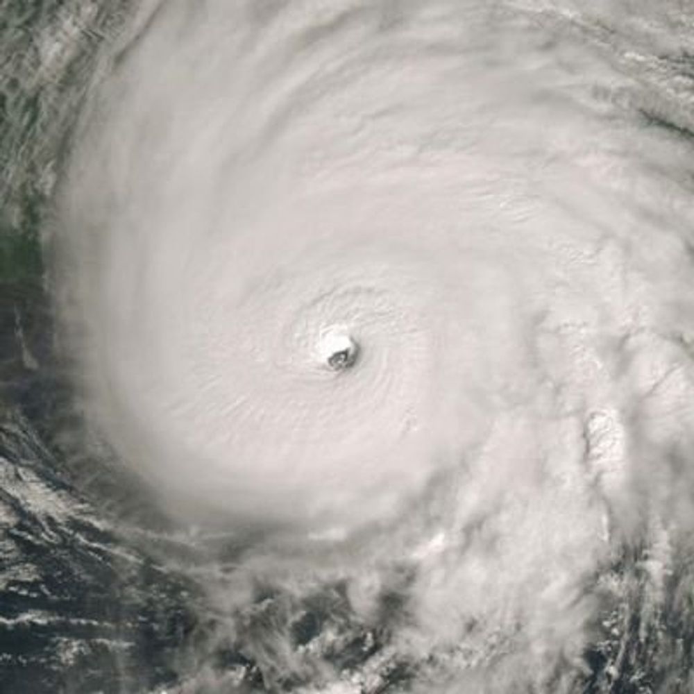
#FungWong has turned out to be a very large typhoon with quite the broad core. This means previous guidance suggestions of a very strong storm did not come to pass, but it also means a larger region impacted as it comes ashore. Stay safe if you are in the path!
November 8, 2025 at 5:34 AM
#FungWong has turned out to be a very large typhoon with quite the broad core. This means previous guidance suggestions of a very strong storm did not come to pass, but it also means a larger region impacted as it comes ashore. Stay safe if you are in the path!
#TD32W has become a large, sprawling tropical cyclone with lower shear and impressive upper divergence. Will be interesting to see the size of the inner core that forms from this. If on the smaller side, will lean towards stronger solutions. Something to keep an eye on this weekend in Luzon
November 5, 2025 at 10:22 PM
#TD32W has become a large, sprawling tropical cyclone with lower shear and impressive upper divergence. Will be interesting to see the size of the inner core that forms from this. If on the smaller side, will lean towards stronger solutions. Something to keep an eye on this weekend in Luzon
#90W is trying to get itself together with an LLC in a broader area of rotation. Some decent upper divergence right now, but it is sheared. The environment will get even more divergent and shear should drop tomorrow. Some guidance has been quite aggressive, we'll see how it fares
November 4, 2025 at 4:00 AM
#90W is trying to get itself together with an LLC in a broader area of rotation. Some decent upper divergence right now, but it is sheared. The environment will get even more divergent and shear should drop tomorrow. Some guidance has been quite aggressive, we'll see how it fares
As it was when it developed, #Melissa is once again sheared. Its MLC is becoming displaced from its LLC, and if you get far enough up, it's much harder to see a TC signature and it turns into a trough in the middle of the jet stream flow. Lots of neat stuff on TDR data!
October 30, 2025 at 9:03 PM
As it was when it developed, #Melissa is once again sheared. Its MLC is becoming displaced from its LLC, and if you get far enough up, it's much harder to see a TC signature and it turns into a trough in the middle of the jet stream flow. Lots of neat stuff on TDR data!
I've added radar data from Taiwan to the lineup. Between this and JMA radar, there's nice coverage in this part of West Pacific to see typhoon structures!
October 30, 2025 at 8:05 PM
I've added radar data from Taiwan to the lineup. Between this and JMA radar, there's nice coverage in this part of West Pacific to see typhoon structures!
#Melissa has impressive outflow and upper divergence beginning as it interacts with the oncoming upper trough. This may allow for another unfortunate burst of intensification (barring an EWRC) as it approaches Jamaica
October 28, 2025 at 4:18 AM
#Melissa has impressive outflow and upper divergence beginning as it interacts with the oncoming upper trough. This may allow for another unfortunate burst of intensification (barring an EWRC) as it approaches Jamaica
As recon leaves, #Melissa's satellite presentation once again improves. Lots of new bursting around the eyewall and another cooling of the CDO. Look at those gravity waves going outwards! Suggests a strengthening storm but satellite trends haven't totally agreed with recon obs lately
October 27, 2025 at 2:58 AM
As recon leaves, #Melissa's satellite presentation once again improves. Lots of new bursting around the eyewall and another cooling of the CDO. Look at those gravity waves going outwards! Suggests a strengthening storm but satellite trends haven't totally agreed with recon obs lately
#Melissa has had several vortical hot towers appear wrap around its eyewall, with another active right now. Likely heralds the beginning of RI when these wrap more. Will certainly be interesting to see what recon finds. Seems tonight will be the long-predicted quick strengthening phase
October 25, 2025 at 9:08 PM
#Melissa has had several vortical hot towers appear wrap around its eyewall, with another active right now. Likely heralds the beginning of RI when these wrap more. Will certainly be interesting to see what recon finds. Seems tonight will be the long-predicted quick strengthening phase
While #Melissa has begun to strengthen and has a well-defined LLC, its MLC is still quite far off to the ESE. Sign of the shear that hasn't quite let up. Will not see more rapid intensification until the tilt reduces
October 25, 2025 at 12:05 AM
While #Melissa has begun to strengthen and has a well-defined LLC, its MLC is still quite far off to the ESE. Sign of the shear that hasn't quite let up. Will not see more rapid intensification until the tilt reduces
Recon found #Melissa has reformed north, but is still misaligned. The LLC is to the west, but the winds reverse as you ascend through the levels, showing the tilt quite well.
P.S. you can create GIFs like this now from the TDR data! Sort of like an MRI of the storm
P.S. you can create GIFs like this now from the TDR data! Sort of like an MRI of the storm
October 24, 2025 at 12:13 AM
Recon found #Melissa has reformed north, but is still misaligned. The LLC is to the west, but the winds reverse as you ascend through the levels, showing the tilt quite well.
P.S. you can create GIFs like this now from the TDR data! Sort of like an MRI of the storm
P.S. you can create GIFs like this now from the TDR data! Sort of like an MRI of the storm