


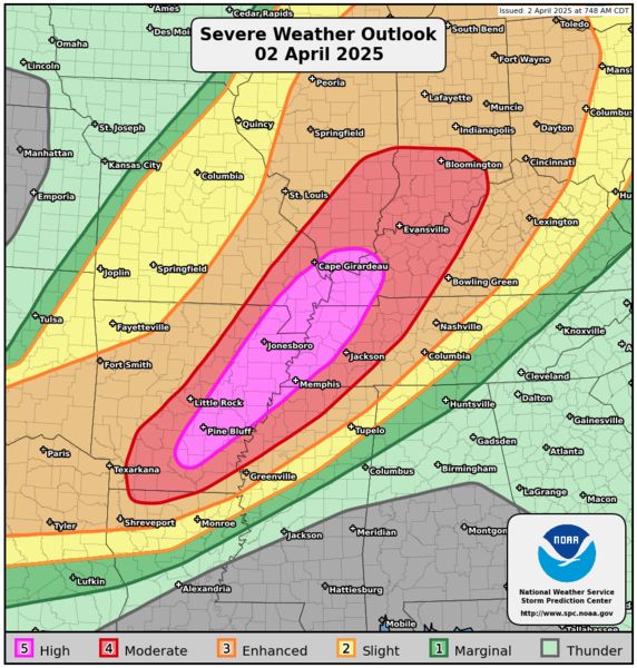
A tornado outbreak is underway from parts of the lower Mississippi Valley into the Mid-South and lower Ohio Valley. Numerous tornadoes are likely. In addition, significant severe wind gusts and very large hail is likely across a broad area from north Texas northeastward to the southern Great Lakes.

April 2, 2025 at 9:49 PM
A tornado outbreak is underway from parts of the lower Mississippi Valley into the Mid-South and lower Ohio Valley. Numerous tornadoes are likely. In addition, significant severe wind gusts and very large hail is likely across a broad area from north Texas northeastward to the southern Great Lakes.
A tornado outbreak is expected today and tonight from the lower Mississippi Valley into the Mid-South and lower Ohio Valley. Numerous tornadoes appear likely. In addition, tornadoes, significant severe wind gusts, and large hail to very large hail are likely.
April 2, 2025 at 4:03 PM
A tornado outbreak is expected today and tonight from the lower Mississippi Valley into the Mid-South and lower Ohio Valley. Numerous tornadoes appear likely. In addition, tornadoes, significant severe wind gusts, and large hail to very large hail are likely.
EXTREMELY CRITICAL FIRE WEATHER AREA FOR PORTIONS OF THE VENTURA VALLEY TO THE SAN BERNARDINO MOUNTAINS IN SOUTHERN CALIFORNIA
EXTREMELY CRITICAL FIRE WEATHER AREA FOR PORTIONS OF THE SAN JACINTO TO LAGUNA MOUNTAIN RANGES
CRITICAL FIRE WEATHER AREA FOR PORTIONS OF SOUTHERN CALIFORNIA
EXTREMELY CRITICAL FIRE WEATHER AREA FOR PORTIONS OF THE SAN JACINTO TO LAGUNA MOUNTAIN RANGES
CRITICAL FIRE WEATHER AREA FOR PORTIONS OF SOUTHERN CALIFORNIA

January 21, 2025 at 12:30 PM
EXTREMELY CRITICAL FIRE WEATHER AREA FOR PORTIONS OF THE VENTURA VALLEY TO THE SAN BERNARDINO MOUNTAINS IN SOUTHERN CALIFORNIA
EXTREMELY CRITICAL FIRE WEATHER AREA FOR PORTIONS OF THE SAN JACINTO TO LAGUNA MOUNTAIN RANGES
CRITICAL FIRE WEATHER AREA FOR PORTIONS OF SOUTHERN CALIFORNIA
EXTREMELY CRITICAL FIRE WEATHER AREA FOR PORTIONS OF THE SAN JACINTO TO LAGUNA MOUNTAIN RANGES
CRITICAL FIRE WEATHER AREA FOR PORTIONS OF SOUTHERN CALIFORNIA
Today: Just your common BLIZZARD WARNING along the Gulf of Mexico…

January 21, 2025 at 12:27 PM
Today: Just your common BLIZZARD WARNING along the Gulf of Mexico…
Here it comes. Gonna be very cold in southern Wisc on Monday & Tuesday

January 12, 2025 at 10:31 PM
Here it comes. Gonna be very cold in southern Wisc on Monday & Tuesday
Some serious winter cold will affect Wisc this coming week…and next.
Tomorrow & Tue, expect Milw area highs in just the low to mid teens, with wind chills below zero both days. Temps won’t be as cold later in the week.
But then, a longer, colder stretch of weather is expected the following week
Tomorrow & Tue, expect Milw area highs in just the low to mid teens, with wind chills below zero both days. Temps won’t be as cold later in the week.
But then, a longer, colder stretch of weather is expected the following week

January 12, 2025 at 2:32 PM
Some serious winter cold will affect Wisc this coming week…and next.
Tomorrow & Tue, expect Milw area highs in just the low to mid teens, with wind chills below zero both days. Temps won’t be as cold later in the week.
But then, a longer, colder stretch of weather is expected the following week
Tomorrow & Tue, expect Milw area highs in just the low to mid teens, with wind chills below zero both days. Temps won’t be as cold later in the week.
But then, a longer, colder stretch of weather is expected the following week
Totals from the lake-effect snow event on Mon Jan 6

January 8, 2025 at 8:28 PM
Totals from the lake-effect snow event on Mon Jan 6
Few more hours of lake-effect snow. Most notably in eastern Racine and Kenosha counties
January 6, 2025 at 3:22 PM
Few more hours of lake-effect snow. Most notably in eastern Racine and Kenosha counties
Lake-effect snow getting underway
January 6, 2025 at 2:59 AM
Lake-effect snow getting underway
2024 climate details for Milwaukee. It was Milwaukee’s WARMEST YEAR ON RECORD (going back to 1871).
Second warmest year? 2023
Second warmest year? 2023

January 6, 2025 at 2:42 AM
2024 climate details for Milwaukee. It was Milwaukee’s WARMEST YEAR ON RECORD (going back to 1871).
Second warmest year? 2023
Second warmest year? 2023
Lake-effect snow tonight into Monday.
As much as 3” possible in parts of Milwaukee county, mainly south of downtown, in Oak Creek, South Milwaukee, Franklin, Cudahy and St. Francis.
As much as 6” possible in Racine and Kenosha counties, mainly from I-94 east to Lake Michigan.
As much as 3” possible in parts of Milwaukee county, mainly south of downtown, in Oak Creek, South Milwaukee, Franklin, Cudahy and St. Francis.
As much as 6” possible in Racine and Kenosha counties, mainly from I-94 east to Lake Michigan.

January 6, 2025 at 1:23 AM
Lake-effect snow tonight into Monday.
As much as 3” possible in parts of Milwaukee county, mainly south of downtown, in Oak Creek, South Milwaukee, Franklin, Cudahy and St. Francis.
As much as 6” possible in Racine and Kenosha counties, mainly from I-94 east to Lake Michigan.
As much as 3” possible in parts of Milwaukee county, mainly south of downtown, in Oak Creek, South Milwaukee, Franklin, Cudahy and St. Francis.
As much as 6” possible in Racine and Kenosha counties, mainly from I-94 east to Lake Michigan.
Tornado WATCH until 6pm for parts of Texas, Louisiana and Arkansas

January 5, 2025 at 4:33 PM
Tornado WATCH until 6pm for parts of Texas, Louisiana and Arkansas
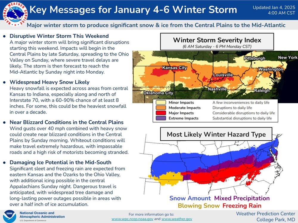
Huge storm from Kansas to Washington DC. Blizzard Warnings, Ice Storm Warnings, etc.

January 5, 2025 at 4:32 PM
Huge storm from Kansas to Washington DC. Blizzard Warnings, Ice Storm Warnings, etc.
Lake-effect snow tonight into Monday. Highest probability and accumulation near and east of a line from Port
Washington to Silver Lake in Kenosha County
Washington to Silver Lake in Kenosha County

January 5, 2025 at 4:16 PM
Lake-effect snow tonight into Monday. Highest probability and accumulation near and east of a line from Port
Washington to Silver Lake in Kenosha County
Washington to Silver Lake in Kenosha County
Major storm next couple days from the Plains to the mid-Atlantic states

January 4, 2025 at 10:56 PM
Major storm next couple days from the Plains to the mid-Atlantic states
Ice storm expected south of Kansas City

January 4, 2025 at 10:48 PM
Ice storm expected south of Kansas City
Over a FOOT OF SNOW expected in northern Kansas and northern Missouri

January 4, 2025 at 10:44 PM
Over a FOOT OF SNOW expected in northern Kansas and northern Missouri
Can I interest you in a BLIZZARD WARNING in Kansas and Missouri?

January 4, 2025 at 10:42 PM
Can I interest you in a BLIZZARD WARNING in Kansas and Missouri?
Lake-effect snow Sunday night into Monday. At this time, highest probability and accumulation from around Milwaukee to the south

January 4, 2025 at 10:34 PM
Lake-effect snow Sunday night into Monday. At this time, highest probability and accumulation from around Milwaukee to the south
January 4, 2025 at 3:02 PM
Violent and deadly tornadoes will threaten the shaded areas of Louisiana, Texas, Arkansas and Mississippi through at least 9pm CST

December 28, 2024 at 8:48 PM
Violent and deadly tornadoes will threaten the shaded areas of Louisiana, Texas, Arkansas and Mississippi through at least 9pm CST
Snow headed into Southeast Wisconsin…
December 23, 2024 at 7:31 PM
Snow headed into Southeast Wisconsin…
