


Chris Page - ITV
@chrispage90.bsky.social
ITV Meteorologist and Weather Presenter
Previously Met Office
STEM Climate Ambassador
All views my own. He/him 🌈☀️
chrispage.co.uk
Previously Met Office
STEM Climate Ambassador
All views my own. He/him 🌈☀️
chrispage.co.uk
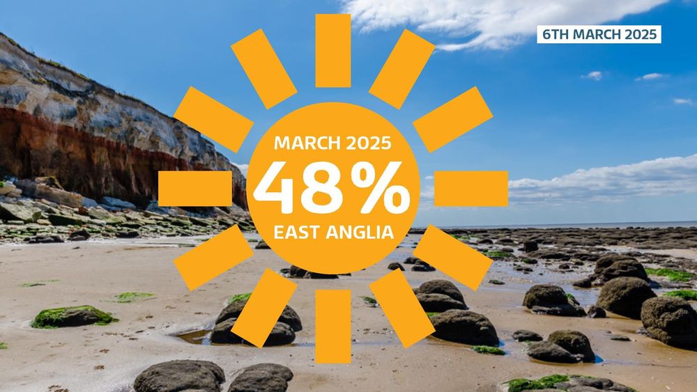
East Anglia has already seen nearly half the normal amount of sunshine for March in just the first six days!
March 7, 2025 at 1:36 PM
East Anglia has already seen nearly half the normal amount of sunshine for March in just the first six days!
The sun's strength is ramping up in the UK! ☀️ We're now approaching the upper level of 2 on the UV index, which is considered low. Level 3 is classed as moderate and it's often advised we should consider wearing sun screen
Here's today's UV reading from the University of Reading
Here's today's UV reading from the University of Reading
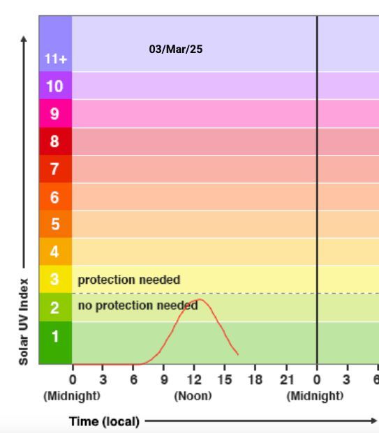
March 3, 2025 at 5:27 PM
The sun's strength is ramping up in the UK! ☀️ We're now approaching the upper level of 2 on the UV index, which is considered low. Level 3 is classed as moderate and it's often advised we should consider wearing sun screen
Here's today's UV reading from the University of Reading
Here's today's UV reading from the University of Reading
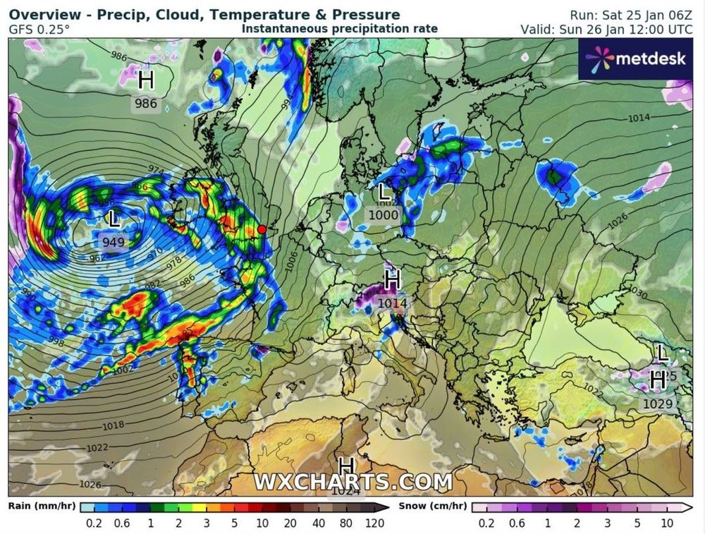
Currently our attention is drawn to the Atlantic where the next storm (named Herminia by Spanish) will bring up to 80mm of rain in parts of the south & west of UK through Sunday and into Monday, followed by further strong gusts of wind. Although not as powerful as Storm Éowyn
January 25, 2025 at 4:54 PM
Currently our attention is drawn to the Atlantic where the next storm (named Herminia by Spanish) will bring up to 80mm of rain in parts of the south & west of UK through Sunday and into Monday, followed by further strong gusts of wind. Although not as powerful as Storm Éowyn
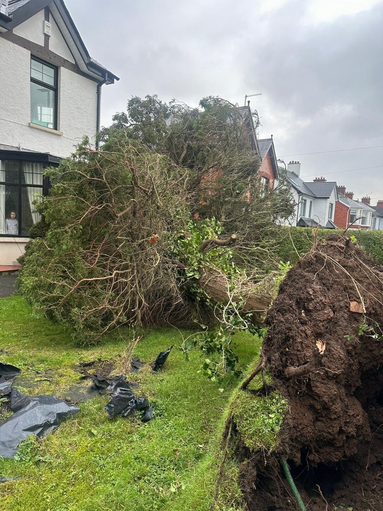
One man sadly died as a tree fell on his car.
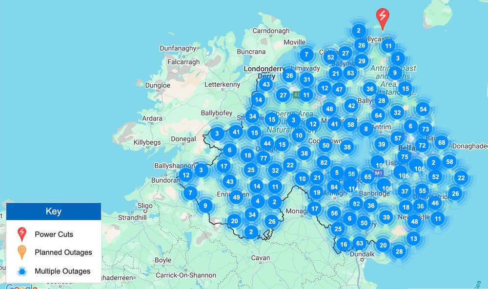
For the UK, 77,000 properties are currently still without power with the majority being in Northern Ireland which could take 10 days to get power back online.
For the UK, 77,000 properties are currently still without power with the majority being in Northern Ireland which could take 10 days to get power back online.
January 25, 2025 at 4:54 PM
One man sadly died as a tree fell on his car.
For the UK, 77,000 properties are currently still without power with the majority being in Northern Ireland which could take 10 days to get power back online.
For the UK, 77,000 properties are currently still without power with the majority being in Northern Ireland which could take 10 days to get power back online.
The storm produced record wind gusts for the Republic of Ireland reaching 114mph (Mace Head), meanwhile 101mph (Drumalbin, Lanarkshire) were recored in the UK. The Met Office believe it was the worst storm for some parts of the UK for 20-30 years.
January 25, 2025 at 4:54 PM
The storm produced record wind gusts for the Republic of Ireland reaching 114mph (Mace Head), meanwhile 101mph (Drumalbin, Lanarkshire) were recored in the UK. The Met Office believe it was the worst storm for some parts of the UK for 20-30 years.
🌀#StormÉowyn a thread
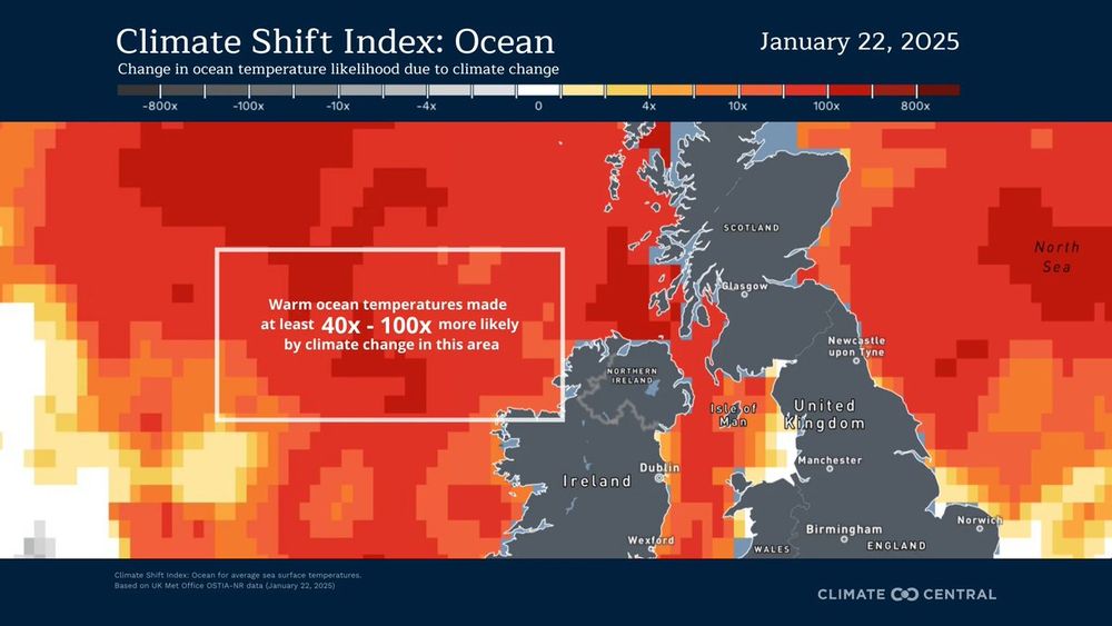
A worrying read but early evidence suggest warmer waters in the Atlantic, caused by man-made climate change, helped to intensify #StormÉowyn according to Climate Central
A worrying read but early evidence suggest warmer waters in the Atlantic, caused by man-made climate change, helped to intensify #StormÉowyn according to Climate Central
January 25, 2025 at 4:54 PM
🌀#StormÉowyn a thread
A worrying read but early evidence suggest warmer waters in the Atlantic, caused by man-made climate change, helped to intensify #StormÉowyn according to Climate Central
A worrying read but early evidence suggest warmer waters in the Atlantic, caused by man-made climate change, helped to intensify #StormÉowyn according to Climate Central
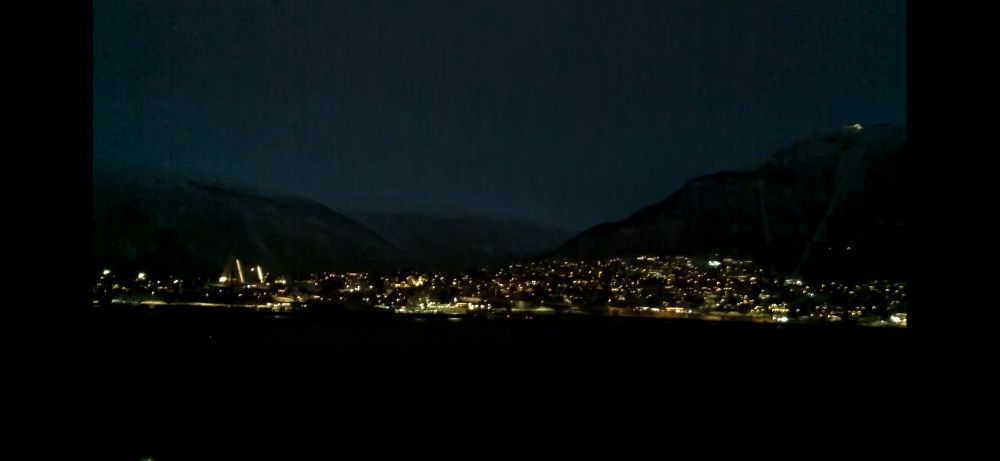
After 49 days of darkness, on Wednesday this week the people of Tromsø, Norway saw the sun for the first time since the 26th November. A total of 54 minutes of daylight for them, as the polar night came to an end for another year!
January 17, 2025 at 6:23 AM
After 49 days of darkness, on Wednesday this week the people of Tromsø, Norway saw the sun for the first time since the 26th November. A total of 54 minutes of daylight for them, as the polar night came to an end for another year!
Something you don’t see every day. People in Upware, Cambridgeshire were ice skating on Sunday after five consecutive days of temperatures being below freezing! 🥶
This is a controlled environment where the ice is 4 inches thick - awesome!
📹 Elizabeth Swan
#iceskating #iceskatingfun
This is a controlled environment where the ice is 4 inches thick - awesome!
📹 Elizabeth Swan
#iceskating #iceskatingfun
January 14, 2025 at 7:50 AM
Something you don’t see every day. People in Upware, Cambridgeshire were ice skating on Sunday after five consecutive days of temperatures being below freezing! 🥶
This is a controlled environment where the ice is 4 inches thick - awesome!
📹 Elizabeth Swan
#iceskating #iceskatingfun
This is a controlled environment where the ice is 4 inches thick - awesome!
📹 Elizabeth Swan
#iceskating #iceskatingfun
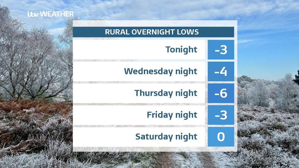
🥶 We've some cold chilly nights to come leading to a severe frost in places. These are the expected rural overnight lows for the coming nights for the ITV Anglia region.
Thursday night is likely to be the coldest night of the winter so far
Thursday night is likely to be the coldest night of the winter so far
January 7, 2025 at 6:12 PM
🥶 We've some cold chilly nights to come leading to a severe frost in places. These are the expected rural overnight lows for the coming nights for the ITV Anglia region.
Thursday night is likely to be the coldest night of the winter so far
Thursday night is likely to be the coldest night of the winter so far
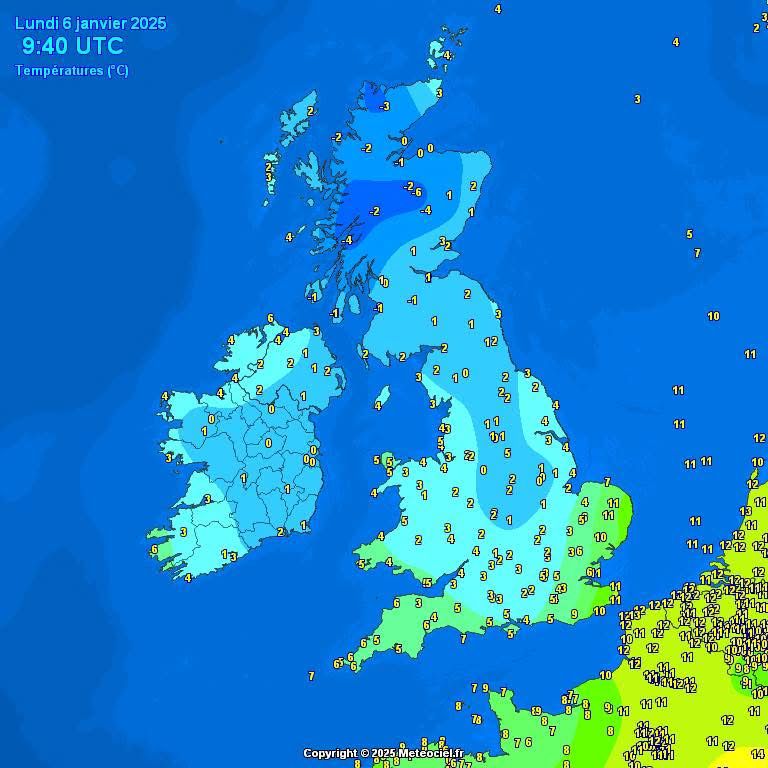
What a contrast in temperatures to start today.
That colder air will spread eastwards through today as the rain and cloud clears up. Keep that woolly pulley to hand this week 🥶
That colder air will spread eastwards through today as the rain and cloud clears up. Keep that woolly pulley to hand this week 🥶
January 6, 2025 at 9:49 AM
What a contrast in temperatures to start today.
That colder air will spread eastwards through today as the rain and cloud clears up. Keep that woolly pulley to hand this week 🥶
That colder air will spread eastwards through today as the rain and cloud clears up. Keep that woolly pulley to hand this week 🥶
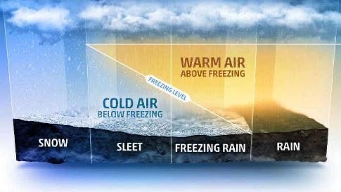
Freezing rain - it's one of the most dangerous winter hazards. We rarely get it in the UK but when it happens it can produce some treacherous conditions.
Find out more in my latest blog post here www.itv.com/news/anglia/...
Find out more in my latest blog post here www.itv.com/news/anglia/...
January 3, 2025 at 2:34 PM
Freezing rain - it's one of the most dangerous winter hazards. We rarely get it in the UK but when it happens it can produce some treacherous conditions.
Find out more in my latest blog post here www.itv.com/news/anglia/...
Find out more in my latest blog post here www.itv.com/news/anglia/...

December 24, 2024 at 11:23 AM
Happy Christmas Eve EVE!
December 23, 2024 at 4:29 PM
Happy Christmas Eve EVE!
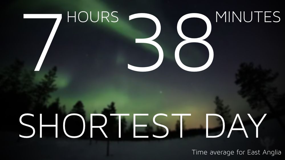
We’ve done it! Welcome to the #shortestday! From this point forward day length gradually increases and the nights get shorter
December 21, 2024 at 8:34 AM
We’ve done it! Welcome to the #shortestday! From this point forward day length gradually increases and the nights get shorter
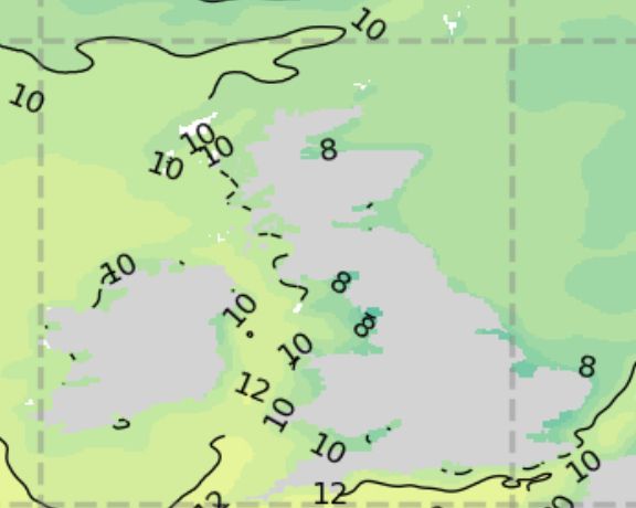
Fancy a festive swim this Christmas? 🎅🏊♂️
Sea temperatures are around 8 Celsius on the East Coast. This is about a degree warmer than what we would expect at this time of year
Sea temperatures are around 8 Celsius on the East Coast. This is about a degree warmer than what we would expect at this time of year
December 18, 2024 at 6:13 PM
Fancy a festive swim this Christmas? 🎅🏊♂️
Sea temperatures are around 8 Celsius on the East Coast. This is about a degree warmer than what we would expect at this time of year
Sea temperatures are around 8 Celsius on the East Coast. This is about a degree warmer than what we would expect at this time of year
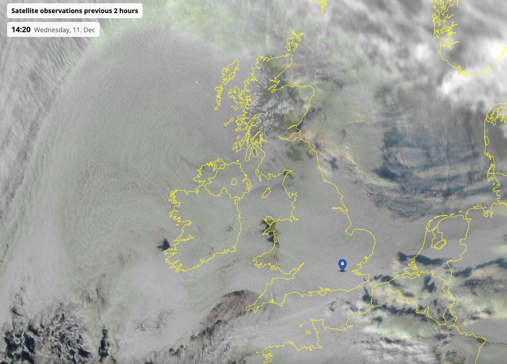
Another day of very little sunshine, here's the earlier satellite imagery from space
@netweather.bsky.social
@netweather.bsky.social
December 11, 2024 at 4:10 PM
Another day of very little sunshine, here's the earlier satellite imagery from space
@netweather.bsky.social
@netweather.bsky.social
Research shows that storm systems like #StormDarragh, which brought gusts of 93 mph over the weekend, are now 2 hPa deeper compared to similar systems in the past.
This means winds are 5% stronger and 10% wetter in the current climate
Source: www.climameter.org/20241206-07-...
This means winds are 5% stronger and 10% wetter in the current climate
Source: www.climameter.org/20241206-07-...

December 10, 2024 at 4:25 PM
Research shows that storm systems like #StormDarragh, which brought gusts of 93 mph over the weekend, are now 2 hPa deeper compared to similar systems in the past.
This means winds are 5% stronger and 10% wetter in the current climate
Source: www.climameter.org/20241206-07-...
This means winds are 5% stronger and 10% wetter in the current climate
Source: www.climameter.org/20241206-07-...
Did the wind keep you up last night? StormDarragh still dominated the weather story across the UK
Strongest gusts across East Anglia since midnight
60mph Holbech
58mph Weybourne
55mph Marham
52mph Wittering
Strongest gusts across East Anglia since midnight
60mph Holbech
58mph Weybourne
55mph Marham
52mph Wittering

December 8, 2024 at 10:27 AM
Did the wind keep you up last night? StormDarragh still dominated the weather story across the UK
Strongest gusts across East Anglia since midnight
60mph Holbech
58mph Weybourne
55mph Marham
52mph Wittering
Strongest gusts across East Anglia since midnight
60mph Holbech
58mph Weybourne
55mph Marham
52mph Wittering
Winds currently light calm in the east as the low centre tracks southeastwards.
For parts of eastern England the worst is yet to come from #StormDarragh
For parts of eastern England the worst is yet to come from #StormDarragh
December 7, 2024 at 10:40 AM
Winds currently light calm in the east as the low centre tracks southeastwards.
For parts of eastern England the worst is yet to come from #StormDarragh
For parts of eastern England the worst is yet to come from #StormDarragh
Latest wind gusts across the UK and Ireland.
74mph at Aberdaron
74mph at Aberdaron

December 6, 2024 at 11:08 PM
Latest wind gusts across the UK and Ireland.
74mph at Aberdaron
74mph at Aberdaron
⚠️ RARE RED WIND WARNING ⚠️
#StormDarragh brings winds with a danger to life
⌛️ Valid Sat 3am to 11am
🌬 Gusts along Irish Sea Coasts and hills of Wales could reach 90mph
🌊 Large waves
🌬 Expect travel disruption, damage to buildings and a danger to life from flying debris
#StormDarragh brings winds with a danger to life
⌛️ Valid Sat 3am to 11am
🌬 Gusts along Irish Sea Coasts and hills of Wales could reach 90mph
🌊 Large waves
🌬 Expect travel disruption, damage to buildings and a danger to life from flying debris

December 6, 2024 at 9:59 AM
⚠️ RARE RED WIND WARNING ⚠️
#StormDarragh brings winds with a danger to life
⌛️ Valid Sat 3am to 11am
🌬 Gusts along Irish Sea Coasts and hills of Wales could reach 90mph
🌊 Large waves
🌬 Expect travel disruption, damage to buildings and a danger to life from flying debris
#StormDarragh brings winds with a danger to life
⌛️ Valid Sat 3am to 11am
🌬 Gusts along Irish Sea Coasts and hills of Wales could reach 90mph
🌊 Large waves
🌬 Expect travel disruption, damage to buildings and a danger to life from flying debris
Storm Darragh (pronounced Da-ra) has been named by the
@metoffice.bsky.social
as potentially damaging winds of up to 80 mph arrive across western areas on Friday into the weekend
Widely wet and windy
#StormDarragh
@metoffice.bsky.social
as potentially damaging winds of up to 80 mph arrive across western areas on Friday into the weekend
Widely wet and windy
#StormDarragh

December 5, 2024 at 9:46 AM
Storm Darragh (pronounced Da-ra) has been named by the
@metoffice.bsky.social
as potentially damaging winds of up to 80 mph arrive across western areas on Friday into the weekend
Widely wet and windy
#StormDarragh
@metoffice.bsky.social
as potentially damaging winds of up to 80 mph arrive across western areas on Friday into the weekend
Widely wet and windy
#StormDarragh
Fab night at the @itvanglia.bsky.social Christmas Party on Friday. Back to the grind tomorrow


December 1, 2024 at 9:51 PM
Fab night at the @itvanglia.bsky.social Christmas Party on Friday. Back to the grind tomorrow
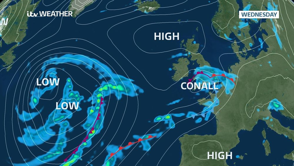
#StormConall has been named by the Dutch Met Service
Heavy rain is expected to impact the south coast of the England with some strong winds tonight and into Wednesday.
The main impacts for wind and rain will be felt across the Netherlands
Heavy rain is expected to impact the south coast of the England with some strong winds tonight and into Wednesday.
The main impacts for wind and rain will be felt across the Netherlands
November 26, 2024 at 4:19 PM
#StormConall has been named by the Dutch Met Service
Heavy rain is expected to impact the south coast of the England with some strong winds tonight and into Wednesday.
The main impacts for wind and rain will be felt across the Netherlands
Heavy rain is expected to impact the south coast of the England with some strong winds tonight and into Wednesday.
The main impacts for wind and rain will be felt across the Netherlands