


Bram van 't Veen
@bramvantveen.bsky.social
Severe storms and radar | Creator of radar viewer NLradar | MSc Climate Physics | Working with radar data for @essl-ecss.bsky.social.
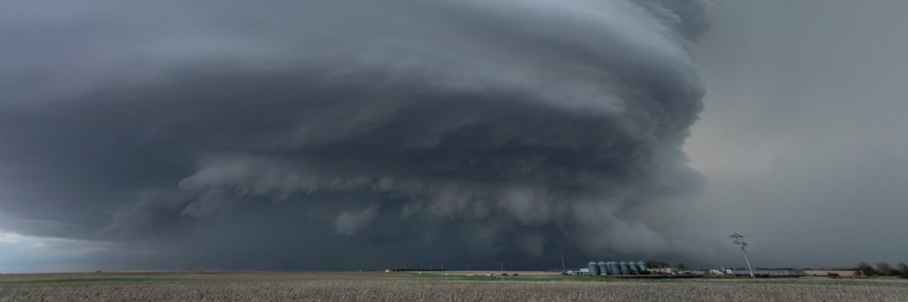
Late yesterday evening featured some strongly rotating storms over the Irish Sea, which were nicely captured by the Dublin radar. Had they occurred over land, we would likely have seen tornado reports.
November 1, 2025 at 5:57 PM
Late yesterday evening featured some strongly rotating storms over the Irish Sea, which were nicely captured by the Dublin radar. Had they occurred over land, we would likely have seen tornado reports.
The start point of the path here nicely matches up with the location where the presumed TDS first appeared, increasing confidence that it was indeed a TDS.
Note by the way that the strong looking couplet on the third image is a dealiasing failure. First image provides most useful doppler data.
Note by the way that the strong looking couplet on the third image is a dealiasing failure. First image provides most useful doppler data.


October 28, 2025 at 8:47 AM
The start point of the path here nicely matches up with the location where the presumed TDS first appeared, increasing confidence that it was indeed a TDS.
Note by the way that the strong looking couplet on the third image is a dealiasing failure. First image provides most useful doppler data.
Note by the way that the strong looking couplet on the third image is a dealiasing failure. First image provides most useful doppler data.
Possible tornado in SW Germany yesterday. And possibly with a radar-detected TDS, as there is a small CC hole at the location of reported damage.
At least this CC hole is not from ground clutter (as is the case for quite some of the green spots in the RGB), as it's not visible at surrounding times.
At least this CC hole is not from ground clutter (as is the case for quite some of the green spots in the RGB), as it's not visible at surrounding times.


October 24, 2025 at 9:56 AM
Possible tornado in SW Germany yesterday. And possibly with a radar-detected TDS, as there is a small CC hole at the location of reported damage.
At least this CC hole is not from ground clutter (as is the case for quite some of the green spots in the RGB), as it's not visible at surrounding times.
At least this CC hole is not from ground clutter (as is the case for quite some of the green spots in the RGB), as it's not visible at surrounding times.
Radar loop of the low-topped supercell that produced yesterday's deadly tornado in France: streamable.com/wpo049. The lack of the nearby Trappes radar sadly meant that the storm wasn't sampled below 2 km AGL, which is quite a limitation. But we can see a clear supercell structure with mesocyclone.


October 21, 2025 at 2:03 PM
Radar loop of the low-topped supercell that produced yesterday's deadly tornado in France: streamable.com/wpo049. The lack of the nearby Trappes radar sadly meant that the storm wasn't sampled below 2 km AGL, which is quite a limitation. But we can see a clear supercell structure with mesocyclone.
We are not yet done in France. Strong rotation near Metz now, suggesting tornado potential. I'm also seeing a small CC minimum for 2 scans now, which might be a small TDS.


October 20, 2025 at 8:17 PM
We are not yet done in France. Strong rotation near Metz now, suggesting tornado potential. I'm also seeing a small CC minimum for 2 scans now, which might be a small TDS.
Thanks, I hadn't seen this one yet. It apparently was produced around the same time as the Ermont tornado, but by the weaker storm NW of it.

October 20, 2025 at 6:21 PM
Thanks, I hadn't seen this one yet. It apparently was produced around the same time as the Ermont tornado, but by the weaker storm NW of it.
An additional tornado suspect from Belgium: www.vrt.be/vrtnws/nl/20.... The responsible storm here also looks very suspicious, with a small hook and clear couplet.


October 20, 2025 at 6:17 PM
An additional tornado suspect from Belgium: www.vrt.be/vrtnws/nl/20.... The responsible storm here also looks very suspicious, with a small hook and clear couplet.
Apparently we also got a tornado in the Netherlands. No report of damage yet. www.facebook.com/RadioSpannen..., www.weerwoord.be/m/3247677

October 20, 2025 at 5:44 PM
Apparently we also got a tornado in the Netherlands. No report of damage yet. www.facebook.com/RadioSpannen..., www.weerwoord.be/m/3247677
This signature north of Abbeville also looks suspicious for a possible TDS:


October 20, 2025 at 5:22 PM
This signature north of Abbeville also looks suspicious for a possible TDS:
I expect that an additional tornado occurred north of Troyes based on radar, given colocation of tight couplet with CC drop => likely TDS:


October 20, 2025 at 5:19 PM
I expect that an additional tornado occurred north of Troyes based on radar, given colocation of tight couplet with CC drop => likely TDS:
There now is indeed a low-topped supercell close to the not-functioning Trappes radar. And there are additional supercells in northern France and southern Belgium.


October 20, 2025 at 3:15 PM
There now is indeed a low-topped supercell close to the not-functioning Trappes radar. And there are additional supercells in northern France and southern Belgium.
Interesting setup over NW and N France today, with clear tornado potential given strongly curved low-level hodographs and sufficient CAPE.
And sadly another setup where we are missing the Trappes radar, which is out of service for replacement since 10 months now...
And sadly another setup where we are missing the Trappes radar, which is out of service for replacement since 10 months now...

October 20, 2025 at 10:29 AM
Interesting setup over NW and N France today, with clear tornado potential given strongly curved low-level hodographs and sufficient CAPE.
And sadly another setup where we are missing the Trappes radar, which is out of service for replacement since 10 months now...
And sadly another setup where we are missing the Trappes radar, which is out of service for replacement since 10 months now...
In most of Europe there is little atmospheric action currently, but central Sweden got a nice line of low-topped storms this afternoon, with embedded rotation: streamable.com/svaazc


October 9, 2025 at 6:50 PM
In most of Europe there is little atmospheric action currently, but central Sweden got a nice line of low-topped storms this afternoon, with embedded rotation: streamable.com/svaazc
A few strong mesocyclones formed last night offshore near the French southeast coast, and I suspect some of these produced a tornadic waterspout. In this radar loop you can nicely see the mesocyclones occluding: streamable.com/6hlp59


September 22, 2025 at 8:41 AM
A few strong mesocyclones formed last night offshore near the French southeast coast, and I suspect some of these produced a tornadic waterspout. In this radar loop you can nicely see the mesocyclones occluding: streamable.com/6hlp59
I think the low CC is due to non-uniform beam filling (e.g. a mixture of rain and hail, or large and small drops). This signature extends down-radial beyond the part of the storm where the non-uniform beam filling occurs.

September 3, 2025 at 4:55 PM
I think the low CC is due to non-uniform beam filling (e.g. a mixture of rain and hail, or large and small drops). This signature extends down-radial beyond the part of the storm where the non-uniform beam filling occurs.
It sadly really seems like we will start today's event with 3 radars in northern France down... Abbeville was in fact up for more than 12 hours since yesterday evening, but went down again 3 hours ago, what a sadness...

September 3, 2025 at 9:18 AM
It sadly really seems like we will start today's event with 3 radars in northern France down... Abbeville was in fact up for more than 12 hours since yesterday evening, but went down again 3 hours ago, what a sadness...
I really hope that @meteofrance.com can get some of their radars in the Northwest working again before tomorrow afternoon, as models indicate an impressive setup for (strong) tornado potential in this region. We are currently missing all 3 radars there...


September 2, 2025 at 9:35 AM
I really hope that @meteofrance.com can get some of their radars in the Northwest working again before tomorrow afternoon, as models indicate an impressive setup for (strong) tornado potential in this region. We are currently missing all 3 radars there...
Quick analysis since I'm on vacation, but that was a very interesting cell indeed! And radar shows a very likely TDS near Guéhenno.


September 2, 2025 at 9:31 AM
Quick analysis since I'm on vacation, but that was a very interesting cell indeed! And radar shows a very likely TDS near Guéhenno.
On this image it looks like one indeed, but when you move through time you'll see that this feature is stationary and associated with ground clutter. It is sometimes hard to distinguish both from just a single image, so I always move through time and check whether a CC drop moves.


September 1, 2025 at 12:20 PM
On this image it looks like one indeed, but when you move through time you'll see that this feature is stationary and associated with ground clutter. It is sometimes hard to distinguish both from just a single image, so I always move through time and check whether a CC drop moves.
Last evening into early night an impressive supercell moved through parts of southern France, cyclically producing at least 5 low-level mesocyclones: streamable.com/rb0qq1 We will have to see whether some produced a tornado. The most suspicious signature is shown in last images, with suspected TDS.


September 1, 2025 at 10:51 AM
Last evening into early night an impressive supercell moved through parts of southern France, cyclically producing at least 5 low-level mesocyclones: streamable.com/rb0qq1 We will have to see whether some produced a tornado. The most suspicious signature is shown in last images, with suspected TDS.
The case near Saint-Hilaire-Bonneval also seems to have a TDS associated with it, which makes 5 highly likely TDSes in France today! Some damage reports for this one: www.facebook.com/reel/2178187..., www.lepopulaire.fr/boisseuil-87...


August 29, 2025 at 8:38 PM
The case near Saint-Hilaire-Bonneval also seems to have a TDS associated with it, which makes 5 highly likely TDSes in France today! Some damage reports for this one: www.facebook.com/reel/2178187..., www.lepopulaire.fr/boisseuil-87...
Brive Grezes, in Southwest France🙂

August 29, 2025 at 7:59 PM
Brive Grezes, in Southwest France🙂
How clear do you want your hook and TDS?


August 29, 2025 at 7:47 PM
How clear do you want your hook and TDS?
It appears, based on radar, that this supercell highly likely produced 2 more tornadoes, given very convincing looking TDSes and couplets! So that was quite the cyclic supercell! Some individual radar frames and 2 loops, both with and without RGB: streamable.com/i2v99i, streamable.com/8f0ygp


August 29, 2025 at 7:41 PM
It appears, based on radar, that this supercell highly likely produced 2 more tornadoes, given very convincing looking TDSes and couplets! So that was quite the cyclic supercell! Some individual radar frames and 2 loops, both with and without RGB: streamable.com/i2v99i, streamable.com/8f0ygp
Beautiful hook echo and likely TDS over France half an hour ago


August 29, 2025 at 5:10 PM
Beautiful hook echo and likely TDS over France half an hour ago